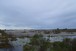
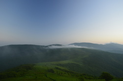
 One of two primitive trails at St. Marks National Wildlife Refuge, the Stoney Bayou Loop follows several old forest roads through several different ecosystems, including pine flatwoods, a cypress swamp, and an open marsh. On this hike, you will get the chance to see an alligator or two, and you will be presented with good birding opportunities near the open marshes. To top of this excellent hike, you will have a vista of Stoney Bayou Loop #1, a large lake that touches the trail. This hike occurred on Friday, January 1st, 2016. My plan was to hike five nature trails at St. Marks National Wildlife Refuge on this day, as well as one of the primitive trails. This was my final stop of the day, and I was going to hike the Stoney Bayou Loop, a primitive trail, clockwise.
2 Comments
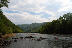
 Two large rivers are the highlights of southern Cherokee National Forest's Ocoee/Hiwassee Ranger District: the Ocoee River and the Hiwassee River. Both rivers run through gorgeous canyons and are full of whitewater rapids. The John Muir Trail (and partially in conjunction with the Benton Mackaye Trail) runs along the northern shores of the Hiwassee River for a distance of nearly 20 miles, presenting opportunities to see the river's rapids and rock formations up close. This hike occurred on October 24th, 2015. My plan was to hike the John Muir Trail/Benton Mackaye Trail from the Big Bend Recreation Area to the Coker Creek footbridge at Duckett Ridge Trailhead. I would return almost the same way, although on the return trip, I would attempt to follow the old route of the John Muir Trail past Apalachia Powerhouse.
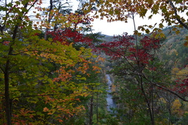
 The Shining Rock Wilderness and adjacent areas is North Carolina's High Country. A multitude of peaks, some above 6000 feet, with astonishing views is accessed via rugged, wilderness pathways from the Blue Ridge Parkway. As you immerse into the backcountry of this wild region, you will also see many water features and scenic streams. My long, difficult hike in this area proved to be spectacular on one fall day when the fall colors were at peak level. This hike occurred on Saturday, October 17th, 2015. My plan was to follow the Mountains-to-Sea Trail from Looking Glass Rock Overlook to Black Balsam Road, with a stop along the way at Skinny Dip Falls and a short side trip to Second Falls in Graveyard Fields. From Black Balsam Road, I would follow the Art Loeb Trail over Black Balsam Mountain, Tennent Mountain, and to Ivestor Gap. From Ivestor Gap, I would take the Greasy Cove Trail to the Big East Fork, and finally, I would take the Big East Fork Trail back to Looking Glass Overlook.
Florida Trail: Bell Springs to Robinson Branch Falls and Big Shoals, White Springs, Florida9/20/2015 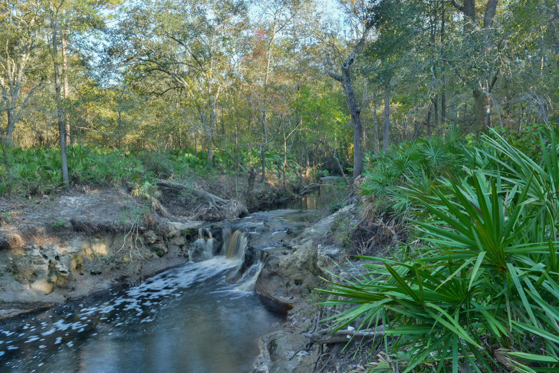
Have you ever wanted to see a waterfall in Florida? Here's your chance. The waterfall on this hike is not high at all, but it's interesting in other aspects, not to mention that it's pretty powerful. Besides the waterfall, you'll get to experience the beauty of the Suwanee River Valley. Additionally, the hike continues to an anomalous natural sight: one of only two Class III whitewater rapids in Florida. This hike occurred on Sunday, July 19th, 2015. My plan was to hike the Florida Trail from the trailhead at Bell Springs to at least Robinson Branch Falls. Depending on conditions, I wanted to visit the Big Shoals on the Suwannee River, but a deep-looking ford of Robinson Branch happened to be my turnaround point, as I didn't have the proper gear for fording at the time. On Saturday, November 4th, 2017, I returned to the Bell Springs section of the Florida Trail at a time of lower water conditions. This time, with proper gear for fording the creek, I hiked all the way to Big Shoals, and the trail report has been updated for the trail between Robinson Branch Falls and Big Shoals.
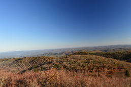
Deep in the mountains of northwestern North Carolina and northeastern Tennessee lie the Highlands of Roan. This widely-known name represents one of the most beautiful spots in the Southeast, and perhaps the entire Appalachian Mountains. This series of mountain balds lies on the route of the Appalachian Trail, and quite a scenic of a hike it is. Whether you're coming here for the spring wildflowers, the autumn foliage show, or after a winter snowstorm, you're not likely to be disappointed (except it may be a little too cold in winter). Although only the most seasoned hiker will be able to do this physically difficult and tiring trek in a single day, there are several variations that can split this hike into several, and then, there's always the backpacking option. This hike occurred on Saturday, June 13th, 2015. My plan was to hike the Appalachian Trail from Carvers Gap over Round Bald, Jane Bald, and Little Hump Mountain, finishing at Big Hump Mountain. I would return the same way. I would also take the spur trails to Grassy Ridge Bald and Overmountain Shelter.
Great Smoky Mountains National Park: Charlie's Bunion via Kephart Prong, Cherokee, North Carolina6/5/2015 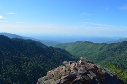
Kephart Prong, named after Horace Kephart, is one of the major tributaries of the Oconaluftee River. The headwaters of Kephart Prong are on the south side of Mount Kephart near the Appalachian Trail. This gorgeous balloon hike takes you from the confluence of Oconaluftee River and Kephart Prong deep into the Kephart Prong drainage, and then up a climb that will get your heart pumping all the way to Charlie's Bunion, a breathtaking vista of the Tennessee side of the Smokies and into the Tennessee River Valley. Your return route takes you past more views and even a couple waterfalls. This hike occurred on Saturday, May 23rd, 2015. My plan was to hike the Kephart Prong Trail to its terminus, and then continue on the Grassy Branch Trail. From there, I would take Dry Sluice Gap Trail to the Appalachian Trail, and take the Appalachian Trail over Mount Kephart and past Charlie's Bunion. I would continue by descending down Sweat Heifer Creek Trail and finishing the hike by going back down Kephart Prong Trail.
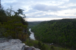
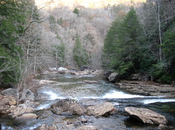
The Big South Fork of the Cumberland River is one of the biggest to bisect the Cumberland Plateau. It flows through a rugged gorge in extreme northern Tennessee and then into Kentucky, before flowing into the Cumberland River near Somerset. This hike is one of the best for your first visit to the area, as it encompasses the shear beauty of the gorge and surroundings, culminating in one of the most beautiful overlooks I have ever encountered anywhere - Angel Falls Overlook - making this one of the best hikes in Tennessee. This hike occurred on Thursday, April 16, 2015. My plan was to start my hike at the East Rim Trailhead. I'd first see East Rim Overlook and do the short hike to Sunset Overlook. And then, I would do the Leatherwood Loop and follow the John Muir Trail to Angel Falls Overlook and back.
Cumberland Trail: Shut-in Gap Road (East Trailhead) to White Pine Cascades, Spring City, Tennessee4/21/2015 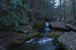
The Piney River is one of the larger waterways that the Cumberland Trail intersects or follows. Amidst its large watershed, the Cumberland Trail visits five cascades and waterfalls, and also provides excellent water views. In addition, visit Twin Rocks Overlook and make a fun rock scramble to reach the views at the top. This hike occurred on Saturday, March 28th, 2015. My plan was to hike the Cumberland Trail from the Piney River/Shut-in Gap Road Trailhead to at least White Pine Cascades with a side trip to Twin Rocks Overlook. Time permitting, I would continue all the way to the western Shut-In Gap Road Trailhead.
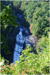
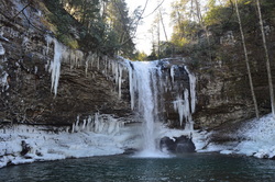 When hearing the name Cumberland Plateau, the plateau and valley pattern in middle Tennessee comes to mind. But did you know the plateau doesn't end there? On its way into Alabama, it passes through the extreme northwestern sliver of Georgia, where one of the most spectacular sights on the entire plateau await: Sitton Gulch. Inside the Gulch, you will find a fine mountain stream and four waterfalls, the highest topping out at 100 feet. And if you want a bonus, do the hike in winter after a cold snap - you won't regret it. This hike occurred on January 10th, 2015, following an Arctic cold blast. My plan was to first hike the Sitton Gulch Trail out and back from the main Cloudland Canyon State Park trailhead. Following this, I would hike the West Rim Loop counter-clockwise.
 The Cataloochee area of the Great Smoky Mountains National Park is an overlooked and very scenic region. Cataloochee Divide marks the eastern boundary of GSMNP in this area, separating Cataloochee Valley and Maggie Valley. Cataloochee Divide Trail might be one of the most spectacular trail in the entire park, if hiked during winter. Views sprout in all directions. However, the section described here is a good hike even during summer, with amazing views from Hemphill Bald and Purchase Knob. Along the way back, take a minute to stop at and explore the Ferguson Cabin located just below Purchase Knob. This hike occurred on Thursday, December 25th, 2014. My plan was to park at the gate on Purchase Road, and then hike up Purchase Road to Purchase Knob. From there, I would pick up the Cataloochee Divide Trail and follow it past the The SWAG to Hemphill Bald. I would retrace my steps back, but instead of climbing back up Purchase Knob, I would shortcut it using the Ferguson Cabin Trail.
 The Southern Cumberland Plateau is an incredibly scenic area. There's dozens of scenic gorges, full of waterfalls and rugged cliffs. North Chickamauga Creek Gorge is one of my ultimate favorites in this area after doing this hike. The rugged mountain streams in this gorge have beautiful waters, the gorge floor is incredibly beautiful, and the views of the upper section of the gorge are.... simply amazing. This hike occurred on Saturday, November 22nd, 2014. My plan was to start this hike from the gate at the end of the open Barker Camp Road, and follow Barker Camp Road on foot to the old turnaround. From there, I would follow an old jeep road to the Cumberland Trail, and take the Cumberland Trail south into North Chickamauga Creek Gorge. Before plunging into the gorge, I would stop at Panther Creek Overlook. Once in the gorge, I would ford Cooper Creek and reach the destination at Stevenson Branch Falls. My original destination was Boston Branch Overlook, but by seeing how much time it took to reach Stevenson Branch Falls, and seeing the deteriorating nature of the trail after Stevenson Branch Falls, I had to cut my plans by some.
Great Smoky Mountains National Park: Mount LeConte via Alum Cave Trail, Gatlinburg, Tennessee11/3/2014 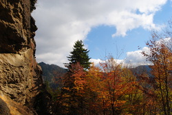 Mount LeConte is one of the most famous mountains in the Southeast. 3rd highest in the Great Smoky Mountains, it has as many as five access trails to the summit. I have done only one, but it is beautiful. Along the way up to LeConte, pass Arch Rock - an arch formed by water over the course of millions of years, and Alum Cave Bluffs - a huge rock overhang of Anakeesta Rock. Also, see the red squirrels, unique to the Southeast, that are found in this area. Near the summit, visit Mount LeConte Lodge and spend the night in the romantic-based lodge or cabins, or if you're like me, squeeze it all in a day hike. It's not that hard. This hike occurred on Saturday, October 18th, 2014. My plan was starting at the Alum Cave Bluffs Trailhead to follow the Alum Cave Trail all the way to the summit of Mt. LeConte. Then, I would visit Cliff Tops, Myrtle Point, and High Point. However, my plans did not include an excellent day changing to wind, fog, and drizzle.
 I have hiked a bit on the Foothills Trail, but in general I have underestimated it. This primer on the Foothills Trail in extreme upstate South Carolina is about as good as it can get while hiking - in fact, this is one of my favorite hikes not only this year, but in the past few years. The Whitewater River starts in the mountains near Cashiers, and grows on its way to Lake Jocassee. There are six waterfalls on the Whitewater River, but two waterfalls are the biggest ones, and more importantly, will take your breath. First, Upper Whitewater Falls is a gigantic double-tiered waterfall, claimed to be the highest waterfall east of the Mississippi River. Following this, the Whitewater River plunges with whitewater through the Whitewater River Gorge, exiting the gorge with another dramatic drop at Lower Whitewater Falls, into Lake Jocassee. This hike occurred on Saturday, October 11th, 2014. My plan was to take the Bad Creek Access Trail to the Foothills Trail, and first take the Foothills Trail east to the Lower Whitewater Falls Trail, and follow it to the Lower Whitewater Falls Overlook. Following this, I would backtrack to the Bad Creek Access Trail, and take the Foothills Trail northwest to Upper Whitewater Falls. After this, I would return the same way to the trailhead.
 Hot Springs is a small, tourist town, with a lot of history and legends behind it. It used to be bigger, but following two consecutive hotel fires, the current resort there is much smaller, so there's not as many people as used to come. For hikers like us, though, the main point of Hot Spring is that the AT passes right through the town, and follows the Main Street sidewalk for a mile. On this hike, there will be multiple features of interest - Lovers Leap Overlook, Mill Ridge, and most importantly, Rich Mountain Fire Tower. This hike occurred on August 30, 2014. Start off by following a section of the Appalachian Trail from Silvermine Trailhead to Rich Mountain. You'll return by a much shorter, albeit steeper way down the Roundtop Ridge Trail back into Hot Springs.
Virgin Falls State Natural Area: Virgin Falls Trail and Caney Fork River Trail, Sparta, Tennessee8/29/2014 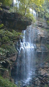 The Caney Fork River's sources are in the northern Cumberland Plateau. On its way to the Tennesee River, it cuts a dramatic gorge known as "Scotts Gulf" near Sparta, TN. The Bridgestone-Firestone Centennial Wilderness protects Scotts Gulf, and an additional tract of land is Virgin Falls State Natural Area. Virgin Falls State Natural Area protects a number of features, with the key feature known as Virgin Falls. The 110-foot high cataract is very rare - it flows out of a cave and disappears int a pit in the ground that leads into an underground cave system. Additionally, Virgin Falls State Natural Area encompasses two more, smaller waterfalls, and a great overlook of Scott's Gulf itself. This hike occurred on Saturday, August 9, 2014. My plan was to do a loop hike with the Virgin Falls Trail, Caney Fork River Trail, and a Connector leading back up to Scott's Gulf Road. Also, on the way, I would check out Sheep Cave, Big Laurel Falls, Big Branch Falls, and Martha's Pretty Point Overlook. However, the plan had to be abandoned as the Caney Fork River Trail's condition deteriorated rapidly. The result was an out and back hike on Virgin Falls Trail and an extension along the Caney Fork River Trail.
|
About MeMark Oleg Ozboyd Dear readers: I have invested a tremendous amount of time and effort in this website and the Georgia Waterfalls Database the past five years. All of the work that has gone in keeping these websites updated with my latest trip reports has almost been like a full-time job. This has not allowed me to pick up a paid job to save up money for college, and therefore, I I've had to take out loans. If you find the information on this website interesting, helpful, or time-saving, you can say "thanks" and help me out by clicking the button above and making a contribution. I will be very grateful for any amount of support you give, as all of it will apply toward my college tuition. Thank you!

Coming in 2022-2023?
Other Hiking WebsitesMiles HikedYear 1: 540.0 Miles
Year 2: 552.3 Miles Year 3: 518.4 Miles Year 4: 482.4 Miles Year 5: 259.9 Miles Archives
March 2021
Categories
All
|
 RSS Feed