HIKING THE APPALACHIANS AND BEYOND
  • Home
  • Trail Reports
    • Best Hikes
    • Hikes with Scenic Views
    • Hikes with Water Features
    • Alabama
    • Georgia
    • Florida
    • North Carolina
    • South Carolina
    • Tennessee
    • Vermont
    • Virginia
  • Map
  • Hike List
  • Testimonials
  • Resources
  • Contact Us
  • Southeast Nature Society
    • Our Team
  • Georgia Waterfalls Database

Chattahoochee National Forest: Waterfalls of Sarahs Creek, Clayton, Georgia

5/31/2017

6 Comments

 
Picture
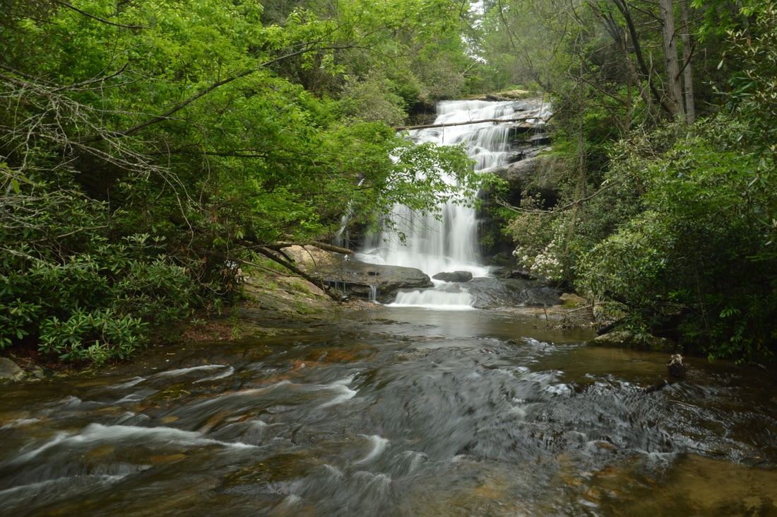
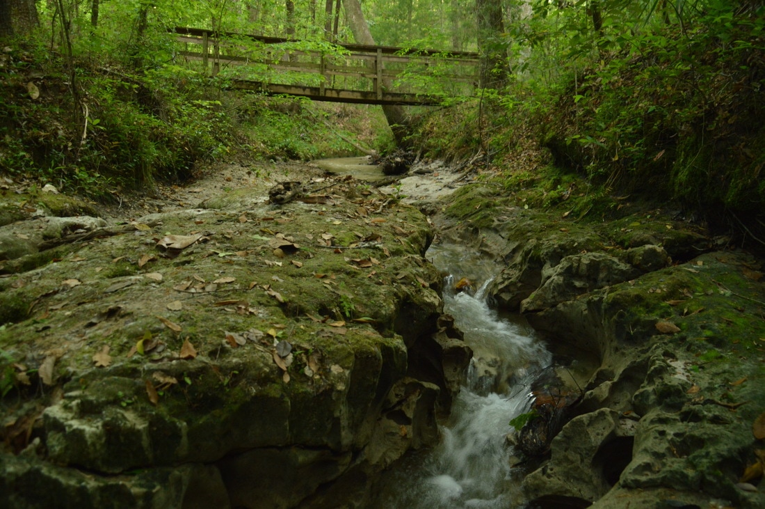
Sarahs Creek is one of a handful of remote streams that drain the slopes of Rabun Bald, Georgia's second highest peak. Most of those streams form noteworthy waterfalls, but while some - such as Holcomb Creek Falls - are popular, others like the two waterfalls on Sarahs Creek are hardly known about. The hike from the end of Forest Road 155C to Upper and Lower Sarahs Creek Falls is fairly easy, but it does entail sections of creek-walk and minor bushwhacking in addition to navigating along faint paths. Those who reach both waterfalls will be rewarded with an interesting upper waterfall in a canyon flanked by a very tall cliff and a pristine lower waterfall that drops around 70 feet. This hike occurred on Saturday, May 27th, 2017. My plan was to hike the gated part of FS 155C from the gate to a faint trail that descended into the Sarahs Creek valley. I would follow the trail for some time, before leaving the trail and bushwhacking down to Sarahs Creek, and hike up the creek to Upper Sarahs Creek Falls. Finally, I would return to the trail and follow it down to Lower Sarahs Creek Falls. I would return the same way. 


Read More
6 Comments

Southern Nantahala Wilderness: Holden Cove Trail/Appalachian Trail/Bly Gap Trail Loop to Oversoul Falls, Ravenrock Cliff Overlook, and Fall Branch Falls, Tate City, Georgia

5/29/2017

2 Comments

 
Picture
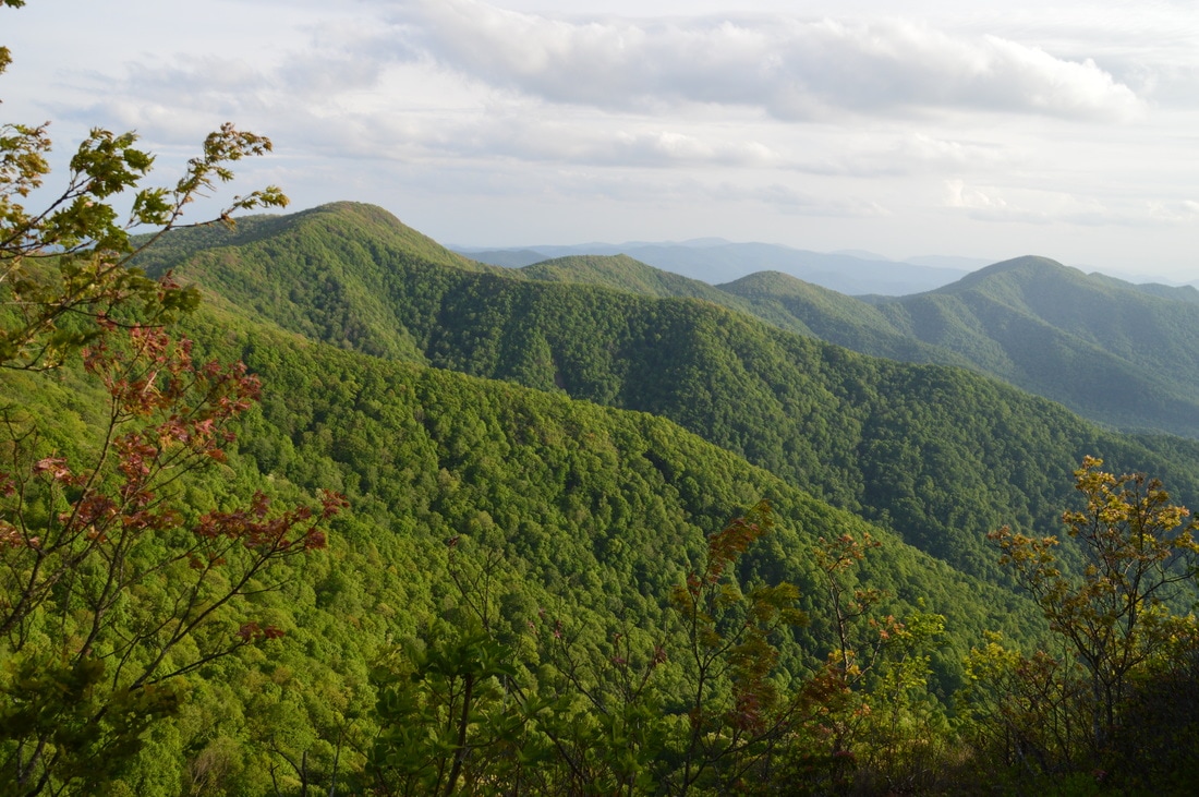
The Upper Tallulah River splits the Southern Nantahala Wilderness's lower region into two nearly separate parts. To the east of the Tallulah River, some of the wilderness's most famous landmarks are situated, such as Standing Indian Mountain, High Falls, and Denton Creek Falls, each of which is reached by well-used trails. The rugged terrain to the west of the Tallulah River tells a whole different story, however. Few official trails traverse this remote area, but a pair of unofficial footpaths provide access from the bottom of the valley all the way to the ridgetops. A beautiful waterfall called Oversoul Falls is found along the unmaintained Holden Cove Trail, and a difficult trek away from the Bly Gap Trail will lead an experienced hiker to Fall Branch Falls, a long series of steep cascades and slides. Even the Appalachian Trail in this area is used lightly compared to many other sections of the AT, and you're not likely to meet any people along the way to the breathtaking Ravenrock Cliff Overlook. This hike was occurred on Saturday, May 20th, 2017. My plan was to begin the day with a surprisingly difficult bushwhack from the Bly Gap Trailhead to Fall Branch Falls. Then, I would move on the main hike of the day, placing a second car at the Holden Cove Trailhead and hiking the Holden Cove Trail past Oversoul Falls to the Appalachian Trail and to Ravenrock Cliff Overlook. I would finish the hike by following the AT to Bly Gap and then hiking the Bly Gap Trail back to the first car. Folks without the option of taking two cars for the hike would have to make a final 2-mile roadwalk to complete the loop. 


Read More
2 Comments

Hinson Conservation & Recreation Area (Chipola River Greenway): Hinson Trail, Marianna, Florida

5/25/2017

0 Comments

 
Picture
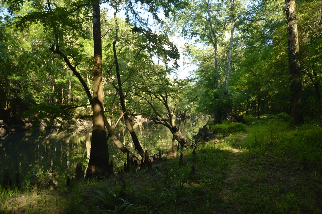
The Chipola River in the Central Florida Panhandle is preserved through many conservation areas, perhaps the best-known of which is Florida Caverns State Park. South of Marianna, however, lies a conservation area that is less-visited but no less interesting: the Hinson Recreation Area, which has a beautiful loop trail that is maintained by the Florida Trail Association. The Hinson Trail presents numerous views of the gorgeous Chipola River, and additionally, there are other highlights that include several sinkholes, an impressive cave that is also a natural bridge, and an abandoned railbed. This hike occurred on Sunday, May 14th, 2017. My plan was to hike the Hinson Loop Trail counter-clockwise from the trailhead at the end of Gator Hole Lane. 


Read More
0 Comments

Point Washington State Forest: Eastern Lake Trail (Orange Loop) to Eastern Lake, Santa Rosa Beach, Florida

5/19/2017

0 Comments

 
Picture
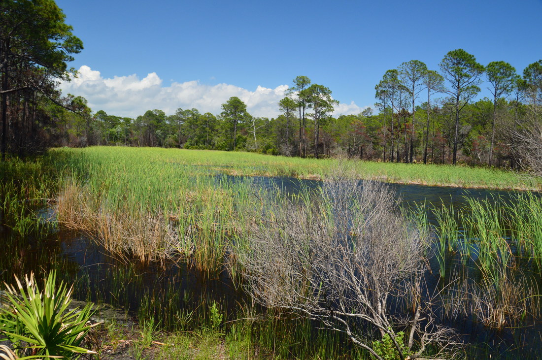
The Gulf of Mexico coastline vicinity in Florida's Walton County is known for its dune lakes. One of the rarest ecosystems in Florida and worldwide, dune lakes are shallow freshwater lakes that are separated from saltwater ocean by thin strips of dunes and beaches. Walton County is home to a whole 17 dune lakes, which are otherwise only found in New Zealand, Madagascar, and Australia. Many of the dune lakes in Walton County are protected by state parks and other conservation areas. One such dune lake, Eastern Lake, is partially private, but its northern shore is part of Point Washington State Forest and is open to public access. The Eastern Lake Trail System consists of several color-coded loops ranging from 3.5 miles to 11 miles that travel through mostly longleaf pine scrub, and additionally, a side trail leads to the edge of Eastern Lake's sparkling blue waters. This hike occurred on Saturday, May 13th, 2017. My plan was to hike the outer loop (Orange Loop) of the Eastern Lake Trail counter-clockwise. Along the way, I would hike the spur trail to Eastern Lake out and back. 


Read More
0 Comments

Torreya State Park: Torreya Loop via Gregory House, Weeping Ridge Trail to Waterfall, and Rock Creek Loop (Torreya Challenge Trail), Bristol, Florida

5/17/2017

0 Comments

 
Picture
Three thousand feet of elevation gain on a hike in the mountains is fairly common; three thousand feet of elevation gain on a hike in Florida is unheard of. Florida is well-known for its flat terrain, but exceptions do exist. Located on the east side of the Apalachicola River in the middle of nowhere, Torreya State Park - one of Florida's most interesting natural areas - features dozens of steephead ravines, limestone bluffs, sharp hills, and even a waterfall. In fact, it is safe to say that the park's hiking trails are the most rugged in Florida. Torreya State Park also boasts a collection of rare plants and animals, including the extremely rare Florida torreya tree, that are not typically found this far south. You'll get quite a workout on this hike, ascending dozens of hills and visiting many scenic mini-canyons carved out by small streams that feed the Apalachicola River. Also, you'll view the Apalachicola River from blufftop overlooks in several places. This hike occurred on Sunday, April 16th, 2017. My plan was to hike the Torreya Loop Trail counter-clockwise starting via the Gregory House east access trail. Along the way, I would make side trips to Weeping Ridge Falls and to Rock Bluff Overlook, and additionally, I would hike the Rock Creek Loop counter-clockwise.


Read More
0 Comments

Sprewell Bluff Park: Upper Flint River Trail, Thomaston, Georgia

5/15/2017

0 Comments

 
Picture
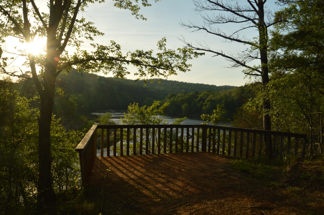
Undammed for nearly two hundred miles until Lake Blackshear near Cordele, the Flint River is one of central and south Georgia's most beautiful large rivers, flowing through several swamps from its headwaters in metro Atlanta. One of the highlights of the river is Sprewell Bluff, a 150-foot bluff towering above the Flint near Thomaston. Other hills and bluffs form a surprisingly narrow and deep gorge on the Flint River in the next few miles upstream. In the 1960s, the splendor of the Flint River in the vicinity of Sprewell Bluff and Thomaston was threatened by the Army Corps of Engineers' proposal of building a dam at Sprewell Bluff, but thankfully, the dam construction proposal was vetoed  in 1974 by President Jimmy Carter. The area around Sprewell Bluff became a Georgia State Park in the early 1990s, and today, it is managed by Upson County. Today, a well-developed trail system, gorgeous roadside overlook, campground, and trading post are to be found in Sprewell Bluff Park. This hike occurred on Friday, April 14th, 2017. My plan was to hike the entire Upper Flint River Trail out and back from Sprewell Bluff Road, although I had to shorten my hike due to a late start. 


Read More
0 Comments

Tray Mountain Wilderness: Waterfalls of Left Fork of Soquee River and Wolfpen Branch, Helen, Georgia

5/9/2017

5 Comments

 
Picture
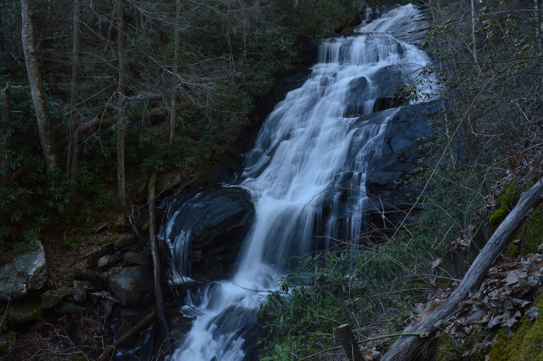
The southeast quadrant of the Tray Mountain Wilderness is home to the headwaters of the Soquee River. Numerous streams join to form the West, Middle, and East Prongs of the Left Fork of the Soquee River, and it is likely that all of the streams have undocumented waterfalls. The grandest of them all is the middle waterfall on the Left Fork: a powerful and remote multi-tier 75-foot waterfall with surprisingly easy access. On the hike to this waterfall, you will also visit the smaller but beautiful lower waterfall and have the options of visiting bonus waterfalls, such as Wolfpen Branch Falls and the upper waterfall on the Left Fork of the Soquee River. This hike occurred on Saturday, April 8th, 2017. My plan was to scout out the easiest route to the biggest waterfall on the Left Fork of Soquee River, described below. 


Read More
5 Comments

Blood Mountain Wilderness: Crow Mountain Creek Trail to Crow Mountain Creek Falls and Blood Mountain Creek Trail to Third Falls (Blood Mountain Creek) and Frogface Falls, Dahlonega, Georgia

5/5/2017

9 Comments

 
Picture
The hike to Blood Mountain's expansive vistas is one of North Georgia's most popular hikes. The valleys on the south side of Blood Mountain are a whole different story, however. Deep in the wilderness, two streams - Crow Mountain Creek and Blood Mountain Creek - form several waterfalls as they make their rapid descent to the Chestatee River. Especially of note is Frogface Falls: a remote 35-foot waterfall that is nestled in the heart of the Blood Mountain Wilderness among tall cliffs. Along the hike to Frogface Falls, you'll follow increasingly fainter paths past two other waterfalls, Third Falls on Blood Mountain Creek and Crow Mountain Creek Falls, each of which is worthy of a visit in their own rights. And if this was not exciting enough, you will also have the opportunity to see several more waterfalls closer to Dicks Creek Road. This hike occurred on Saturday, April 1st, 2017. My plan was to hike the Crow Mountain Creek Trail past Crow Mountain Creek Falls to the Blood Mountain Creek Trail, where I would follow the latter trail past Third Falls and to Frogface Falls (with the last portion being off-trail). I would return the same way along the Blood Mountain Creek Trail, but instead of taking the Crow Mountain Creek Trail back, I would walk along Dicks Creek Road back to my car, visiting up to three other waterfalls if I had time.


Read More
9 Comments

Chattahoochee National Forest: Darnell Creek Loop Trail to Ramey Creek Falls, Dillard, Georgia

5/1/2017

0 Comments

 
Picture
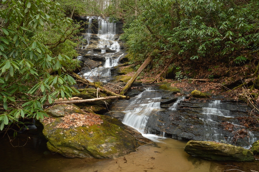
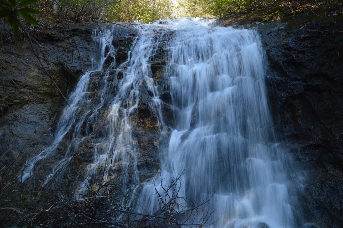
The Darnell Creek area is known for its abundance of notable waterfalls. All of the waterfalls on Darnell Creek and Thomas Creek - one of its two headwater tributaries - are close to Darnell Creek Road and are reached via short and easy hikes. But what about Darnell Creek's other headwater tributary, Ramey Creek? This creek, which is in no way less scenic than Thomas Creek, flows considerably further south and is reached by the Darnell Creek Trail: a well-established trail that first follows Darnell Creek and then Ramey Creek. The Darnell Creek Trail's biggest highlight is a 45-foot waterfall on Ramey Creek. Situated at the head of a narrow gorge, Ramey Creek Falls is a photogenic waterfall featuring a cliff over which the waterfall initially plunges, followed by a series of cascades down a number of rock outcrops. Taking the waterfall aside though, the Darnell Creek Trail is still a very pretty trail that passes numerous cascades and small waterfalls on Darnell Creek and Ramey Creek, in addition to a panoramic wintertime view of the grand 100-foot Big Falls on Thomas Creek in the distance across the valley. This hike occurred on Saturday, March 25th, 2017. My plan was to hike the Darnell Creek Trail to Ramey Creek Falls. From Ramey Creek Falls, I would add variety to my hike by hiking the TR 61A Loop (Darnell Creek Loop), rejoining the Darnell Creek Trail at Pine Gap Branch and retracing my steps the rest of the way to the trailhead. 


Read More
0 Comments

    About Me

    Mark Oleg Ozboyd
    I'm an avid outdoor explorer and a hobbyist landscape photographer. I'm 21 years old and have been hiking since 2011. Originally based out of Atlanta, Georgia, I started out by occasionally hiking short trails throughout well-known Georgia State Parks. During 2012 and 2013, I began to expand my trips into adjacent states, as well as into the wilder National Forest areas rather than just State Parks. Throughout the years that followed, as I slowly ran out of popular hiking trails in my area, I began to search for and hike in more seldom-visited areas. Today, you can find me out in the woods every weekend, whether it's on an official trail or bushwhacking through cross-country terrain without any paths. I now attend Washington & Lee University and am exploring Virginia and West Virginia. My other hobbies include chess, science, old music, and meteorology. I have 3 years of amateur weather forecasting experience, having studied a lot of meteorology basics over the years. I am also a student at European School of Music where I learned that music and nature have a lot in common. Listening to good music inspires me to capture nature's beauty on the camera in different aspects that also make me recall many beautiful music pieces that I've heard.​


    Dear readers: I have invested a tremendous amount of time and effort in this website and the Georgia Waterfalls Database the past five years. All of the work that has gone in keeping these websites updated with my latest trip reports has almost been like a full-time job. This has not allowed me to pick up a paid job to save up money for college, and therefore, I I've had to take out loans. If you find the information on this website interesting, helpful, or time-saving, you can say "thanks" and help me out by clicking the button above and making a contribution. I will be very grateful for any amount of support you give, as all of it will apply toward my college tuition. Thank you! 

    Enter your email address to subscribe for trail reports:

    Delivered by FeedBurner


    Picture
    Coming in 2022-2023?

    Other Hiking Websites

    DWHike's Adventures
    Florida's Natural Wonders
    Florida Trailblazer
    Meanderthals
    Mountain Images
    by Bernie Boyer

    North Carolina Waterfalls with
    ​Kevin Adams
    Take-a-Hike!
    Tennessee Landforms
    Waterfall Page
    Waterfall Adventurer
    Zach's Mild Adventures

    Miles Hiked

    Year 1: 540.0 Miles
    Year 2: 552.3 Miles
    ​Year 3: 518.4 Miles
    Year 4: 482.4 Miles
    Year 5: 259.9 Miles

    Archives

    March 2021
    February 2021
    January 2021
    November 2019
    October 2019
    September 2019
    August 2019
    July 2019
    June 2019
    February 2019
    January 2019
    December 2018
    November 2018
    October 2018
    August 2018
    July 2018
    June 2018
    May 2018
    April 2018
    March 2018
    February 2018
    January 2018
    December 2017
    November 2017
    October 2017
    September 2017
    August 2017
    July 2017
    June 2017
    May 2017
    April 2017
    March 2017
    February 2017
    January 2017
    December 2016
    November 2016
    October 2016
    September 2016
    August 2016
    June 2016
    May 2016
    April 2016
    March 2016
    January 2016
    December 2015
    November 2015
    October 2015
    September 2015
    August 2015
    July 2015
    June 2015
    May 2015
    April 2015
    March 2015
    February 2015
    January 2015
    December 2014
    November 2014
    October 2014
    September 2014
    August 2014
    July 2014
    June 2014
    May 2014
    April 2014
    March 2014
    February 2014

    Categories

    All
    Adel
    Adirondack Park
    Alabama
    Alfred A. Ring Park
    Allegheny Trail
    Amicalola Falls State Park
    Anniston Area
    Apalachicola Bluffs And Ravines Preserve
    Apalachicola National Forest
    Apalachicola/Port St. Joe Area
    Apopka
    Appalachian Trail
    Appling
    Art Loeb Trail
    Aska Trail System
    Bakersville
    Balm-Boyette Scrub Preserve
    Balsam Lake Recreation Area
    Bankhead National Forest
    Bartow County Parks
    Bartram Trail
    Basinger
    Beersheba Springs
    Benton
    Benton Mackaye Trail
    Berry College Trail System
    Best Hike
    Big South Fork National Recreation Area
    Black Bear Wilderness
    Black Rock Mountain State Park
    Blairsville
    Blakely
    Blood Mountain Wilderness
    Blowing Rock
    Blue Ridge
    Blue Ridge Parkway
    Boone
    Bradenton
    Bradenton Beach
    Brasstown Bald
    Brasstown Wilderness
    Brevard
    Bryson City
    Buchanan
    Bucks Pocket State Park
    Bulow Creek State Park
    Bulow Plantation Ruins State Park
    Caesars Head State Park
    Caladesi Island State Park
    Calhoun
    Camel's Hump State Park
    Cashiers
    Caspersen Beach Park
    Catfish Creek State Park
    Caves
    CC Putnam State Forest
    Cedar Point Environmental Park
    Chatsworth
    Chattahoochee National Forest
    Chattanooga
    Chattanooga Valley
    Chattooga National Wild And Scenic River
    Cheaha Wilderness
    Cherohala Skyway
    Cherokee
    Cherokee National Forest
    Chiefland Area
    Chillhowee Recreation Area
    Chipley
    Chunky Gal Trail
    Circle B Bar Reserve
    Citico Creek Wilderness
    Citrus Wildlife Management Area
    Clarkesville
    Clayton
    Cleevland
    Cleveland
    Cloudland Canyon State Park
    Cohutta Wilderness
    Collier-Seminole State Park
    Cordele
    Cornelia
    Covington
    Crestview Area
    Crew-land-and-water-trust
    Cullowhee
    Cumberland Trail
    Dahlonega
    Dalton
    Dawson Forest Wildlife Management Area
    Dawsonville
    Dayton
    De Soto National Memorial
    DeSoto State Park
    Dillard
    Double Springs
    Ducktown
    Duncan Ridge Trail
    Dunlap
    Eagle's Rest Park
    Eastpoint
    Econfina Creek Wildife Management Area
    Eglin Air Force Base
    Elizabethton
    Elkins
    Elk Knob Game Lands
    Elk Park
    Ellicott Rock Wilderness
    Ellijay
    Emerson Point Preserve
    Englewood Area
    Enota Retreat
    Erwin
    Falling Waters State Park
    Fayetteville
    Fires Creek Recreation Area
    Fire Tower
    Flint River
    Florence Area
    Florida
    Florida Caverns State Park
    Florida Trail
    Foothills Trail
    Fort Mountain State Park
    Fort Myers Area
    Fort Payne
    Fort Payne Area
    Fort Yargo State Park
    Franklin
    Franklin Delano Roosevelt State Park
    Franklin-Marion State Forest
    Frozen Head State Park
    Gainesville
    Gainesville Area
    Gatlinburg
    George Washington National Forest
    Georgia
    Georgia Veterans Memorial State Park
    Glasgow
    Gorges State Park
    Grandfather Mountain State Park
    Great Smoky Mountains National Park
    Greeneville
    Green River Game Lands
    Gruetli-Laager
    Grundy Forest State Natural Area
    GTM Reserve
    Guana River Wildlife Management Area
    Hayesville
    Helen
    Hiawassee
    High Falls State Park
    Highlands
    Highlands Scenic Highway
    Hillsborough River State Park
    Hinson Conservation & Recreation Area
    Historic Sites
    Honeymoon Island State Park
    Hot Springs
    Huntington
    Inverness Area
    Jackson
    Jasper
    Jefferson National Forest
    Joan M. Durante Park
    Jonathan Dickinson State Park
    Jones Gap State Park
    Joyce Kilmer Slickrock Wilderness
    Joyce Kilmer - Slickrock Wilderness
    Juniper Prairie Wilderness
    Kelly Park
    Keown Falls Recreation Area
    Kolomoki Mounds State Park
    LaFayette
    Lake City Area
    Lake George Wild Forest
    Lake June-in-Winter State Park
    Lakeland Area
    Lake Placid
    Lake Russell Wildlife Management Area
    Lake Wales Ridge State Forest
    Laurel Fork North Wilderness
    Leffis Key Preserve
    Leon Sinks Geological Area
    Lexington
    Lineville
    Linville
    Linville Gorge Wilderness
    Lithia Springs
    Little Frog Wilderness
    Little Manatee River State Park
    Little River Canyon National Preserve
    Longboat Key
    Long Trail
    Lookout Mountain
    Lookout Mountain Battlefield
    Lovingston
    Lula Lake Land Trust
    Lumpkin
    Maggie Valley
    Manatee Springs State Park
    Marianna Area
    Mark Trail Wilderness
    Marlinton
    Mccaysville
    McMinville
    Mentone
    Middlesex
    Mistletoe State Park
    Monongahela National Forest
    Montreat
    Mountain Bridge Wilderness Area
    Mountain City
    Mountains To Sea Trail
    Mountains-to-Sea Trail
    Mount Rogers National Recreation Area
    Myakka River State Park
    Myron B. Hodge City Park
    Nantahala National Forest
    Naples
    Naples Area
    Natural Bridge State Park
    Neal Preserve
    New Castle
    Newport
    New River Gorge National Park
    New York
    North Carolina
    Ocala Area
    Ocala National Forest
    Ocean-to-Lake Trail
    Oconee State Park
    Oconee Station Historic Site
    Okaloacoochee Slough State Forest
    Oldsmar
    Oneida
    Orlando Area
    Ormond Beach
    Oscar Scherer State Park
    Oxford
    Palatka
    Palmetto Trail
    Panama City Area
    Panthertown Valley
    Parrish
    Paynes Creek Historic State Park
    Peaks Of Otter Recreation Area
    Pigeon Crockford Mountain Wildlife Management Area
    Pigeon-Crockford Mountain Wildlife Management Area
    Pigeon-Crockford Wildlife Management Area
    Pine Mountain
    Pinhoti Trail
    Pinnacle Park
    Pisgah Civitan Park
    Pisgah National Forest
    Pittman Center
    Pond Mountain Wilderness
    Ponds/Lakes
    Prentice Cooper State Forest
    Providence Canyon State Park
    Pumpkintown
    Quick Point Nature Preserve
    Raven Cliffs Wilderness
    Reed Bingham State Park
    Reliance
    Rice Creek Conservation Area
    Riverview Pointe Preserve
    Robbinsville
    Robinson Preserve
    Rock Creek Gorge Scenic Area
    Rock Island State Park
    Rome
    Rosman
    Sale Creek
    Salem
    Salt Springs
    Saluda
    Santa Rosa Beach
    Sarasota
    Sarasota Area
    Savage Gulf State Natural Area
    Scenic Views
    Scottsboro Area
    Sebring Area
    Sewanee
    Sheltowee Trace Trail
    Shining Rock Wilderness
    Signal Mountain
    Sipsey Wilderness
    Sky Valley
    Smithgall Woods State Park
    Snowbird Backcountry Area
    Soddy Daisy
    Soddy-Daisy
    Sopchoppy
    South Carolina
    South Cumberland State Park
    Southeastern Cave Conservancy
    Southern Nantahala Wilderness
    Sparta
    Sprewell Bluff Park
    Spring City
    Spring Hill
    Springs
    Spruce Pine
    Standing Indian Backcountry Area
    St. Augustine
    St. George Island State Park
    St. Joseph Bay State Buffer Preserve
    St. Marks Area
    St. Marks National Wildlife Refuge
    Stone Mountain
    Stone Mountain Park
    Suches
    Sumatra
    Sumter National Forest
    Suwannee River
    Swallow Creek Wildlife Management Area
    Sweetwater Creek State Park
    Sylva
    Talladega National Forest
    Tallahassee Area
    Tallulah Falls
    Tallulah Gorge State Park
    Tampa Bay Area
    Tate City
    Tate's Hell State Forest
    Tea Creek Wildlife Management Area
    Tellico Plains
    Tennessee
    Thomaston
    Toccoa
    Topsail Hill State Park
    Torreya State Park
    Townsend
    Tracy City
    Tray Mountain Wilderness
    Trenton
    Triple Creek Preserve
    Troutdale
    Unaka Mountain Wilderness
    Upper Tampa Bay County Park
    Venice
    Vermont
    Virgin Falls State Natural Area
    Virginia
    Virginia Outdoors Foundation
    Vogel State Park
    Wakulla Springs State Park
    Waleska
    Walhalla
    Wartburg
    Water Features
    Waynesville
    Weedon Island Preserve
    Weeki Wachee Preserve
    Wekiwa Springs State Park
    West Palm Beach Area
    West Virginia
    Whitehall
    White Springs
    Winder
    Withlacoochee State Forest
    Young Harris

    RSS Feed

TRAIL REPORTS

Hikes in Alabama
​Hikes in Florida
Hikes in Georgia
Hikes in North Carolina
Hikes in South Carolina
Hikes in Tennessee
Hikes in Virginia

Hiking Resources

Alabama Resources
​
Florida Resources
Georgia Resources
North Carolina Resources
​South Carolina Resources
​
Tennessee Resources

Other

Contact
Map of Hikes
Alphabetical List of Hikes
Southeast Nature Society
© COPYRIGHT 2014-2018
​ALL RIGHTS RESERVED.
Important: I disclaim any responsibility for any damage or personal injury that may occur as a result of the activities and information found on this website. All outdoor activities, especially off-trail hiking, are done at your own risk. Never hike or head into that area that may be above your fitness or experience level.
  • Home
  • Trail Reports
    • Best Hikes
    • Hikes with Scenic Views
    • Hikes with Water Features
    • Alabama
    • Georgia
    • Florida
    • North Carolina
    • South Carolina
    • Tennessee
    • Vermont
    • Virginia
  • Map
  • Hike List
  • Testimonials
  • Resources
  • Contact Us
  • Southeast Nature Society
    • Our Team
  • Georgia Waterfalls Database