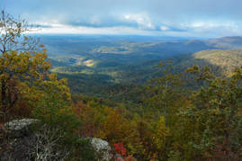
Preachers Rock is a well-known destination along the Appalachian Trail on Big Cedar Mountain that features a great view of the Blood Mountain Wilderness. A couple of other trails in the area can be utilized to create a loop hike from either Chestatee Overlook (on Highway 60) or Dockery Lake, visiting one other vista as well as up to three waterfalls. The unofficial Steeltrap Knob Trail provides a useful connection between Chestatee Overlook and Woody Gap, at the same visiting a spectacular view of the Georgia Piedmont from little-known cliffs on the side of Steeltrap Knob. Meanwhile, the Dockery Lake Trail travels through the Pigeon Roost Creek Valley between Dockery Lake and the Appalachian Trail. While no waterfalls are right on the trail, visiting Martha's Falls, Twin Falls, and Dockery Lake Falls will require only short off-trail diversions. This hike occurred on Sunday, October 29th, 2017. My plan was to hike a loop from Chestatee Overlook, starting with the Steeltrap Knob Trail and stopping by the Steeltrap Knob Vista along the way. I would then take the Appalachian Trail over Big Cedar Mountain and to the Dockery Lake Trail, stopping by several views from Big Cedar Mountain along the way, including Preachers Rock. Next, I would take the Dockery Lake Trail to Dockery Lake, visiting Twin Falls, Martha's Falls, and Dockery Lake Falls along the way. I would conclude the hike with a walk up Dockery Lake Road back to Highway 60 and Chestatee Overlook.
0 Comments
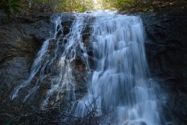
The hike to Blood Mountain's expansive vistas is one of North Georgia's most popular hikes. The valleys on the south side of Blood Mountain are a whole different story, however. Deep in the wilderness, two streams - Crow Mountain Creek and Blood Mountain Creek - form several waterfalls as they make their rapid descent to the Chestatee River. Especially of note is Frogface Falls: a remote 35-foot waterfall that is nestled in the heart of the Blood Mountain Wilderness among tall cliffs. Along the hike to Frogface Falls, you'll follow increasingly fainter paths past two other waterfalls, Third Falls on Blood Mountain Creek and Crow Mountain Creek Falls, each of which is worthy of a visit in their own rights. And if this was not exciting enough, you will also have the opportunity to see several more waterfalls closer to Dicks Creek Road. This hike occurred on Saturday, April 1st, 2017. My plan was to hike the Crow Mountain Creek Trail past Crow Mountain Creek Falls to the Blood Mountain Creek Trail, where I would follow the latter trail past Third Falls and to Frogface Falls (with the last portion being off-trail). I would return the same way along the Blood Mountain Creek Trail, but instead of taking the Crow Mountain Creek Trail back, I would walk along Dicks Creek Road back to my car, visiting up to three other waterfalls if I had time.
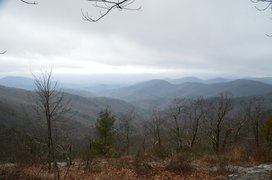
One of Georgia's most scenic hikes is along the Appalachian Trail from Neels Gap to Hogpen Gap. Along this section of the AT, the famed long-distance footpath passes over several summits that offer outstanding long-range vistas. Along the way, you will first walk along the only piece of the AT that passes under a building, at the Walasi-Yi Interpretive Center. Afterwards, you will hike across Levelland Mountain, Wolf Laurel Top, Cowrock Mountain, and Wildcat Mountain, each of which has its own breathtaking view (or several). This hike occurred on Saturday, February 11th, 2017. My plan was to hike the Byron Herbert Reece Trail from US 129 to the Appalachian Trail. There, I would pick up the Appalachian Trail and follow it through Neels Gap and to Hogpen Gap. Along the way, I would make side trips to views on Levelland Mountain and Cowrock Mountain. I arranged to have two cars for this point-to-point hike: one car was placed at the Byron Herbert Reece Trailhead and another car was placed at the Hogpen Gap Trailhead.
Blood Mountain Wilderness: Slaughter Creek Loop and Blood Mountain via Freeman Loop, Suches, Georgia12/20/2016 
Blood Mountain is one of the best-known mountains in Georgia for a variety of reasons, including the ease of access to the great views from the several rock slabs near the summit of the peak. The easiest approach to the top is from Highway 129, but several other trails, in addition to the Appalachian Trail itself, are found in the vicinity of Blood Mountain. Two such trails - the Jarrard Gap Trail and Slaughter Creek Trail - leave the Lake Winfield Scott Recreation Area and access the AT west of Blood Mountain. Another trail, the Freeman Trail, winds around hollows on the south side of Blood Mountain, providing a tricky passage through numerous boulder fields. You'll walk all of these trails as you hike to Blood Mountain using the "back way". This hike occurred on Saturday, October 15th, 2016. My plan was to hike the Jarrard Gap Trail from Lake Winfield Scott to the Appalachian Trail, from where I would follow the AT to the Freeman Trail, taking the spur trail to Woods Hole Shelter. Then, I would take the Freeman Trail around the south side of Blood Mountain, before meeting the Appalachian Trail again and following it to the top of Blood Mountain. I would finish the hike by descending on the Appalachian Trail to the Slaughter Creek Trail and taking the Slaughter Creek Trail back to Lake Winfield Scott.
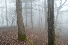
Vogel State Park is nestled in a small north Georgia valley in the middle of Chattahoochee National Forest near Blood Mountain. The park is home to several hiking trails, including the Coosa Backcountry Trail, a well-known hiking trail that traverses two mountains in its dozen-mile course. On this hike, you will climb to a small vista of the valley in which Vogel State Park lies, before approaching Slaughter Bald and bagging Coosa Bald. This hike is especially good in winter, as much of the hike traverses ridges and slopes with great views when the trees are bare - as long as it is not foggy. This foggy hike occurred on Saturday, February 20, 2016. My plan was to hike the northern and eastern section of the Bear Hair Gap Loop and most of the Coosa Backcountry Trail.
|
About MeMark Oleg Ozboyd Dear readers: I have invested a tremendous amount of time and effort in this website and the Georgia Waterfalls Database the past five years. All of the work that has gone in keeping these websites updated with my latest trip reports has almost been like a full-time job. This has not allowed me to pick up a paid job to save up money for college, and therefore, I I've had to take out loans. If you find the information on this website interesting, helpful, or time-saving, you can say "thanks" and help me out by clicking the button above and making a contribution. I will be very grateful for any amount of support you give, as all of it will apply toward my college tuition. Thank you!
Coming in 2022-2023?
Other Hiking WebsitesMiles HikedYear 1: 540.0 Miles
Year 2: 552.3 Miles Year 3: 518.4 Miles Year 4: 482.4 Miles Year 5: 259.9 Miles Archives
March 2021
Categories
All
|

 RSS Feed