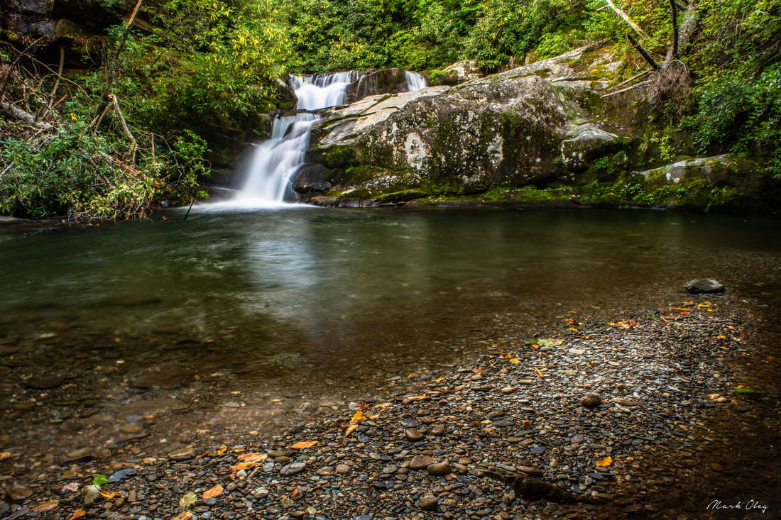
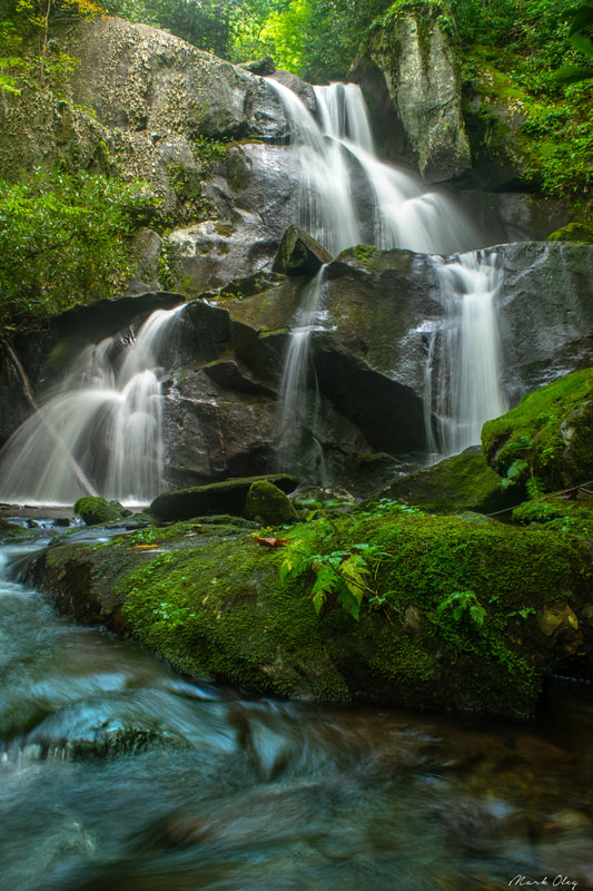
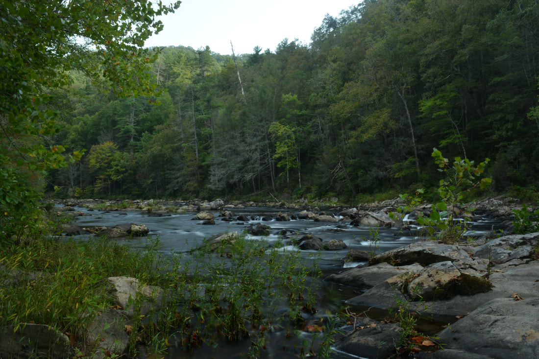
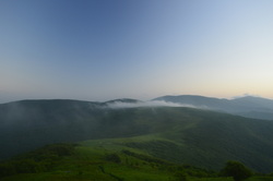
Imagine a large mountain waterway winding its way through a wilderness for nearly a dozen miles with zero road access. Picture a rugged, little-traveled pathway following this waterway, crisscrossing the creek many times through deep, slick fords, circumnavigating countless blowdowns and rock scrambles. There, you've discovered the Slickrock Creek Trail! This is the best creek trail I've ever walked in the Southern Appalachian Mountains, and I'm not even exaggerating. Nowhere else have I found a combination of such remote beauty and rugged wilderness trail, which never follows any of the logging roads customary to most North Carolina waterways. As if you needed more incentive to tackle this hike, the Slickrock Creek Trail features two secluded waterfalls - Wildcat Falls and Lower Falls - with swimming holes that couldn't be any more refreshing after a long summer day in the backcountry. This hike occurred on Saturday, September 15th, 2018. My plan was to day hike a lengthy loop through the heart of the Joyce Kilmer-Slickrock Creek Wilderness backcountry. I would start off along the Slickrock Creek Trail at Cheoah Dam along US 129, but before long, I would take the Ike Branch Trail. At Yellowhammer Gap, I would pick up the Yellowhammer Gap Trail, followed by the Nichols Cove Trail and Windy Gap Trail. The Windy Gap Trail would finally bring me to Slickrock Creek, from where I'd spend the rest of the day tracing the Slickrock Creek Trail back to US 129.
0 Comments
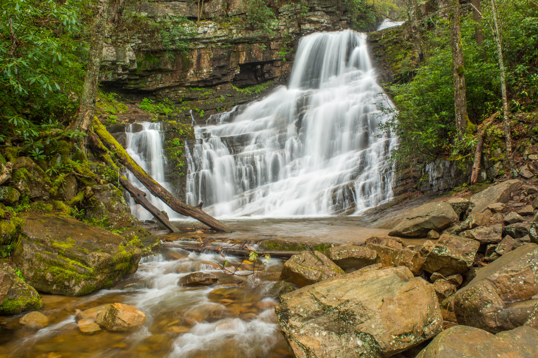
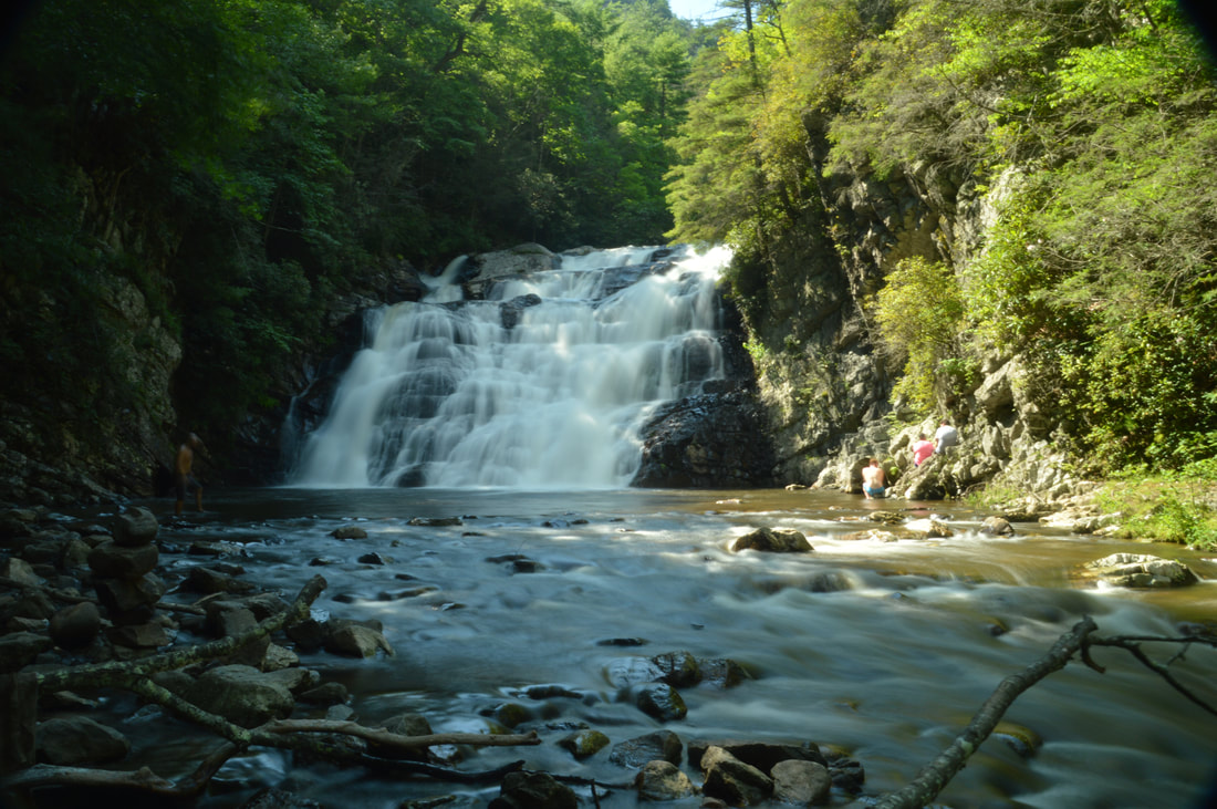
Nestled between the Little Tennessee River and the Cherohala Skyway, the 16,226-acre Citico Creek Wilderness features some of East Tennessee's most remote hiking trails. The primary focus points of the wilderness are its two major waterways: the North and South Forks of Citico Creek. Seldom-traveled trails follow both streams, crisscrossing them many times along the way, and providing numerous views of the creeks' many scenic cascades and pristine banks. Even better, a short scramble off the North Fork Trail is the spectacular Old Goat Falls, crashing 40 feet through a cleft amidst ferny cliffs. This hike, an ambitious loop along both forks of Citico Creek all the way to their headwaters, is among the best creek hikes in Cherokee National Forest. This hike occurred on Saturday, September 1st, 2018. My plan was to initially follow the South Fork Trail from Citico Creek Road to the North Fork Trail junction. There, I would pick up the North Fork Trail and climb it to Cherry Log Gap, scrambling down to Old Goat Falls along the way. I would then follow the Benton MacKaye Trail from Cherry Log Gap to Cold Spring Gap, from where I would take the South Fork Trail back to Citico Creek Road.

The scenic crest of the Bald Mountains that straddles the Tennessee/North Carolina border south of Greeneville, TN, features a set of spectacular vistas in the vicinity of the Appalachian Trail. The views actually begin even before you leave your car as you arrive at the beautiful Jones Meadow with a panoramic vista of Camp Creek Bald and Blackstack Cliffs. Two excellent vistas are accessed by a very short, easy walk from the parking area: Whiterock Cliff facing south into North Carolina and Blackstack Cliffs facing north into Tennessee. The Appalachian Trail then continues onto a new section, which scrambles along the knife-edge ridge-crest for over a mile across Big Firescald Knob, affording several outstanding 360-degree panoramic vistas. On your return trip, you may choose to follow the alternate bad-weather AT route, a little-used pathway on the north flanks of Big Firescald Knob that adds variety to the hike. This hike occurred on Friday, April 27th, 2018. My plan was to hike the Appalachian Trail from Jones Meadow over Big Firescald Knob, taking side trails to Whiterock Cliff and Blackstack Cliffs along the way. Rather than retracing my steps along the Big Firescald Knob ridge-crest, I would return along the AT bad-weather bypass. This hike was the third of six hikes that I did during a four-day trip to the mountains of northeast Tennessee and northwest North Carolina.
Nestled in the Bald Mountains of Northeast Tennessee, the West Fork Dry Creek valley features some of the area's most beautiful streamside scenery. A well-known hiking trail, the Margarette Falls Trail, climbs along West Fork Dry Creek close to a mile past numerous scenic cascades to the 60-foot fan-shaped drop of Margarette Falls. Above Margarette Falls is a very unique waterfall called Bailey Falls. Accessed exclusively by an off-trail creek-walk, Bailey Falls consists of separate 30-foot upper and 20-foot lower sections in a gorgeous slot canyon. For experienced waterfallers, Bailey Falls is a must-see - no other waterfall quite like it is known in Tennessee. This hike occurred on Friday, April 27th, 2018. My plan was to hike the Margarette Falls Trail out and back to Margarette Falls. I would continue following a goat path past Margarette Falls and then walk the creek to Lower & Upper Bailey Falls. This hike was the second of six hikes that I did during a four-day trip to the mountains of northeast Tennessee and northwest North Carolina.
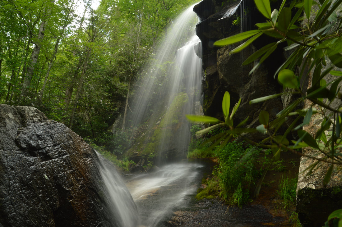
Streams flowing off the north slopes of Unaka Mountain feature many of Northeast Tennessee's finest waterfalls. Particularly notable is a stream called Dick Creek, which features four stunning waterfalls in the Unaka Mountain Wilderness, including a unique 25-foot quadruple-flow falls and a spectacular 60-foot part-free-falling waterfall. All four waterfalls can be accessed out of Rock Creek Recreation Area via the Rattlesnake Ridge Trail, Dick Creek Trail/Road, and an unofficial pathway along Dick Creek. Additionally, a more popular waterfall - Rock Creek Falls - can be included on this hike, as it's also accessed out of Rock Creek Recreation Area along the Rock Creek Falls Trail, a very scenic trail with numerous stream views and even a bonus waterfall. This hike occurred on Thursday, April 26th, 2018. My plan was to hike out and back along the Rattlesnake Ridge Trail and Dick Creek Trail/Road to the waterfalls on Dick Creek. I would then return to the Rock Creek Recreation Area and hike the Rock Creek Trail out and back to Rock Creek Falls. This hike was the first of six hikes that I did during a four-day trip to the mountains of northeast Tennessee and northwest North Carolina.

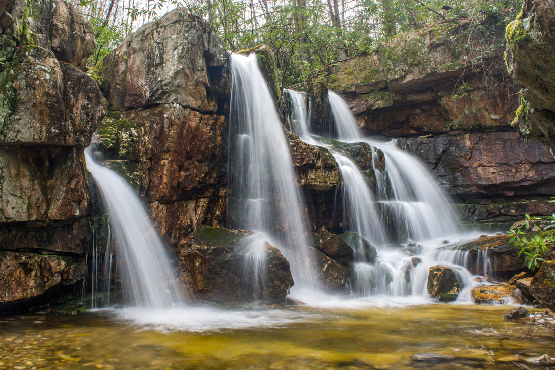
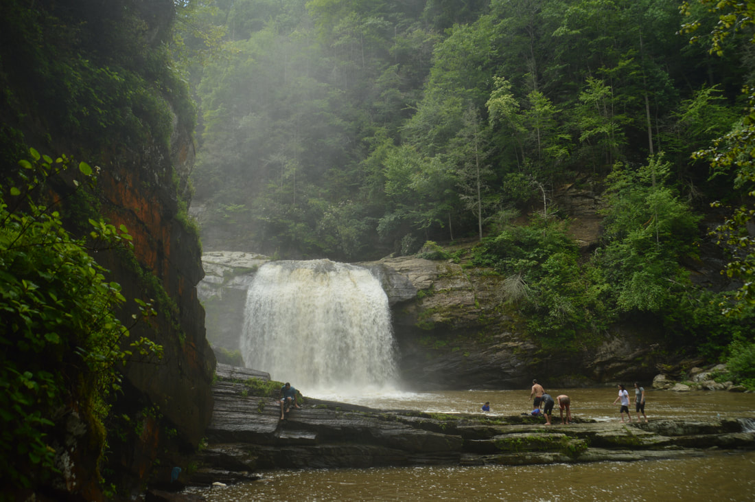
The 244-acre Rock Creek Gorge Scenic Area in Polk County is one of Southeast Tennessee's most spectacular natural areas. The Rock Creek Gorge is home to a jaw-dropping sixteen named waterfalls, spread across Rock Creek and several of its tributaries flowing off Chilhowee Mountain. All are scenic and many are tall. The only easily-accessible waterfalls are Rock Creek Falls, Benton Falls, and arguably Chestnut Mountain Falls. All of the others involve various degrees of creek-walking and/or bushwhacking. While one could visit all sixteen falls in one day, it will require a high level of physical capability and off-trail experience. Folks who chose to visit the waterfalls in several different trips will still be well-rewarded. The best time of year to visit the waterfalls of the Rock Creek Gorge Scenic Area is winter or spring, when the waterfalls are flowing more boldly and when the area is less overgrown. This hike occurred on Saturday, April 14th, 2018. My plan was to hike the Scenic Spur Trail from Highway 30 to Rock Creek Falls. I would follow a scramble path to Chestnut Mountain Falls. From there, I would begin the off-trail section of the hike by first visiting the waterfalls on Laurel Branch and then walking up Rock Creek past several waterfalls to the Slickrock Branch confluence. Next, I would bushwhack alongside Slickrock Branch out to the Rim Rock Trail, visiting more waterfalls along the way. I would then follow the Clemmer Trail to Benton Falls, also bushwhacking to Elora Falls and Silvermine Branch Falls. Finally, I would return to Highway 30 along the Clemmer Trail.
The Iron Mountain Loop is one of the less-used trails in the Cohutta Mountains. Most folks who visit the Conasauga River choose to hike the Conasauga River Trail #11 in the Cohutta Wilderness proper, well above the Jacks River confluence. On the other hand, the Iron Mountain Trail combines with Cherokee National Forest's Conasauga River Trail #61 to showcase a much broader and equally pristine section of the Conasauga River below the Jacks River confluence, where two mighty mountain rivers join into one. Although much of the Iron Mountain Trail is just a peaceful wooded walk across the slopes of Iron Mountain, a small vista at the halfway point offers a welcome break with a view of the West Cowpen Ridge that forms the Cohutta Wilderness boundary. The Iron Mountain Loop has only one downside: it gets a fair amount of equestrian traffic. This hike occurred on Saturday, September 23rd, 2017. My plan was to hike the Iron Mountain Loop clockwise by first following the Iron Mountain Trail from Cottonwood Patch Campground and then hiking the Conasauga River Trail to FS 221. The loop would be concluded with a short roadwalk along FS 221 and FS 16.
The 55-foot Laurel Falls is one of Northeast Tennessee's most breathtaking waterfalls. Located just outside of the community of Hampton and off the Appalachian Trail in Pond Mountain Wilderness, access to Laurel Falls is fairly easy, making it a destination that can often be crowded, but the falls and the whole hike is still worthwhile - for there is a lot more to see along this stretch of the AT. Above Laurel Falls, an unofficial side trail makes a steep scramble to the pointy summit of Potato Top, where there are several excellent views of the Laurel Fork Gorge and surrounding wilderness. In addition, the Appalachian Trail between US 321 and Dennis Cove Road passes a lot of pretty creekside scenery and several spectacular cliffs that rise along Laurel Fork Creek. This hike occurred on Sunday, July 9th, 2017. My plan was to hike out and back along the Hampton Blueline Trail and then Appalachian Trail from the trailhead off US 321 near Hampton to the Dennis Cove Trailhead. Along the way, I would take the side trails to Potato Top and Laurel Falls, and on my way back, I would take the high-water bypass route past Laurel Fork Shelter above Laurel Falls for a bit of variation. This hike was the eighth of ten hikes that I did during a seven-day trip to the mountains of northwest North Carolina.
The Elk River is best known for its spectacular upper waterfall, Elk River Falls. But as the Elk River enters Tennessee, it encounters a twisting passage with a series of waterfalls collectively known as Twisting Falls that is even more jaw-dropping. The 35-foot lowermost drop of Twisting Falls, locally known as Compression Falls, creates one of the area's most impressive sights as it crashes with a deafening roar into a deep pool flanked by tall cliffs. The trail to the base of the falls is no joke though - the unofficial path descends over 400 feet to the Elk River in just a quarter-mile! The destination waterfall is well worth it, but be prepared to huff and puff on the way back up. This hike occurred on Wednesday, July 5th, 2017. My plan was to hike out and back to the base of the lowermost drop of Twisting Falls (aka Compression Falls). This hike was the second of ten hikes that I did during a seven-day trip to the mountains of northwest North Carolina.
If you're looking for the perfect combination of beauty and ease of access to a waterfall in North Carolina, Elk River Falls has to be at the top of your list. A well-used relaxing trail leads along the banks of the mighty Elk River to the base of Elk River Falls, a tight sheer 50-foot drop into a huge plunge pool that is known for its swimming opportunities. Most folks who hike to Elk River Falls don't know that another excellent waterfall can be reached fairly easily from the same trailhead. 100-foot Jones Falls is on a small tributary of the Elk River and during the wetter months is a sight no less impressive than Elk River Falls. A signed spur trail from the Appalachian Trail facilitates access to this gorgeous spot. Hikers will be able to see both waterfalls with a hike of fewer than four miles. This hike occurred on Wednesday, July 5th, 2017. My plan was to hike out and back to Elk River Falls and then to follow a forest road and unofficial connector path to the Appalachian Trail, which I would use to reach Jones Falls. I would return the same way. This hike was the first of ten hikes that I did during a seven-day trip to the mountains of northwest North Carolina.
The Unicoi Mountains straddle the Tennessee/North Carolina border in the Cherohala Skyway area. Bob Bald is one of the higher mountains in the range. At an elevation of 5294 feet, Bob Bald provides extensive views of the Citico Creek Wilderness and Joyce Kilmer-Slickrock Wilderness. There are several different ways to reach Bob Bald, but the easiest one is from Beech Gap on the Cherohala Skyway. You will first follow an abandoned forest road along the State Line Ridge, before taking off onto a singletrack trail that leads straight to Bob Bald. This hike occurred on Saturday, February 27, 2016. My plan was to hike closed Forest Road 217H from Beech Gap to the Bob Bald Connector Trail. From there, I would take the Bob Bald Connector Trail to the summit of Bob Bald. After visiting Bob Bald, I would return the same way.
The Citico Creek Wilderness is one of the wildest areas in southeast Tennessee. A network of trails provides foot access into the pristine watershed. Falls Branch Falls, located at the head of a remote valley on a tributary of South Fork Citico Creek, is the tallest waterfall in the Citico Creek Wilderness. From the Cherohala Skyway, take a short trail into the Falls Branch Scenic Area and through an old-growth forest to Falls Branch and the 80-foot falls. This hike occurred on Saturday, February 27, 2016. My plan was to hike the Falls Branch Falls Trail out and back from the Cherohala Skyway to Falls Branch Falls. After this short hike, I would drive to nearby Beech Gap on the Cherohala Skyway and complete a longer hike, detailed in a separate trail report.
 The Warriors Passage Trail is one of two National Recreational Trails in Cherokee National Forest. This seldom-traveled pathway traverses a couple of low-elevation stream valleys before climbing up to Waucheesi Mountain, a small bald summit with views across the Tellico Ranger District. This hike occurred on Saturday, November 14th, 2015. My plan was to hike the entire Warriors Passage Trail out and back from Lyons Creek Trailhead to Waucheesi Mountain.
 Two large rivers are the highlights of southern Cherokee National Forest's Ocoee/Hiwassee Ranger District: the Ocoee River and the Hiwassee River. Both rivers run through gorgeous canyons and are full of whitewater rapids. The John Muir Trail (and partially in conjunction with the Benton Mackaye Trail) runs along the northern shores of the Hiwassee River for a distance of nearly 20 miles, presenting opportunities to see the river's rapids and rock formations up close. This hike occurred on October 24th, 2015. My plan was to hike the John Muir Trail/Benton Mackaye Trail from the Big Bend Recreation Area to the Coker Creek footbridge at Duckett Ridge Trailhead. I would return almost the same way, although on the return trip, I would attempt to follow the old route of the John Muir Trail past Apalachia Powerhouse.
Deep in the mountains of northwestern North Carolina and northeastern Tennessee lie the Highlands of Roan. This widely-known name represents one of the most beautiful spots in the Southeast, and perhaps the entire Appalachian Mountains. This series of mountain balds lies on the route of the Appalachian Trail, and quite a scenic of a hike it is. Whether you're coming here for the spring wildflowers, the autumn foliage show, or after a winter snowstorm, you're not likely to be disappointed (except it may be a little too cold in winter). Although only the most seasoned hiker will be able to do this physically difficult and tiring trek in a single day, there are several variations that can split this hike into several, and then, there's always the backpacking option. This hike occurred on Saturday, June 13th, 2015. My plan was to hike the Appalachian Trail from Carvers Gap over Round Bald, Jane Bald, and Little Hump Mountain, finishing at Big Hump Mountain. I would return the same way. I would also take the spur trails to Grassy Ridge Bald and Overmountain Shelter.
|
About MeMark Oleg Ozboyd Dear readers: I have invested a tremendous amount of time and effort in this website and the Georgia Waterfalls Database the past five years. All of the work that has gone in keeping these websites updated with my latest trip reports has almost been like a full-time job. This has not allowed me to pick up a paid job to save up money for college, and therefore, I I've had to take out loans. If you find the information on this website interesting, helpful, or time-saving, you can say "thanks" and help me out by clicking the button above and making a contribution. I will be very grateful for any amount of support you give, as all of it will apply toward my college tuition. Thank you!

Coming in 2022-2023?
Other Hiking WebsitesMiles HikedYear 1: 540.0 Miles
Year 2: 552.3 Miles Year 3: 518.4 Miles Year 4: 482.4 Miles Year 5: 259.9 Miles Archives
March 2021
Categories
All
|
 RSS Feed