One of Georgia's most scenic hikes is along the Appalachian Trail from Neels Gap to Hogpen Gap. Along this section of the AT, the famed long-distance footpath passes over several summits that offer outstanding long-range vistas. Along the way, you will first walk along the only piece of the AT that passes under a building, at the Walasi-Yi Interpretive Center. Afterwards, you will hike across Levelland Mountain, Wolf Laurel Top, Cowrock Mountain, and Wildcat Mountain, each of which has its own breathtaking view (or several). This hike occurred on Saturday, February 11th, 2017. My plan was to hike the Byron Herbert Reece Trail from US 129 to the Appalachian Trail. There, I would pick up the Appalachian Trail and follow it through Neels Gap and to Hogpen Gap. Along the way, I would make side trips to views on Levelland Mountain and Cowrock Mountain. I arranged to have two cars for this point-to-point hike: one car was placed at the Byron Herbert Reece Trailhead and another car was placed at the Hogpen Gap Trailhead.
2 Comments
Florida Caverns State Park might be Florida's most famous state park, as it is the only state park with a show tour cave. Nestled in some of Florida's taller hills near the Chipola River, the park has a lot to offer in terms of outdoor recreation besides a public cave tour. The park is home to two trail systems: a smaller nature trail system east of the Chipola River and a longer trail system west of the river, and most people who visit the park to be guided through the cave are not aware of the beauty that awaits a short distance away on the park's trails. Along the short nature trail system, you will pass several limestone bluffs with great views of the Chipola River floodplain, and you will even hike through Tunnel Cave on Florida's only trail that passes through a cave. This hike occurred on Monday, January 2nd, 2017. My plan was to hike counter-clockwise the outermost loop in Florida Caverns State Park's nature trail system, by first hiking the Beech-Magnolia Trail, followed by the Floodplain Trail and Tunnel Cave.

The Roaring Run gorge in Virginia's Blue Ridge sports numerous scenic slides and cascades, on top of a spectacular 35-foot Roaring Run Falls. Several short nature trails provide easy access to this pristine location. The area also has an interesting iron ore mining history, which can be observed today in the form of the Roaring Run Furnace, an iconic sight along this short loop hike in the vicinity of Roaring Run. This hike occurred on Saturday, November 26th, 2016. My plan was to hike the Roaring Run Falls Loop clockwise, by first following the Streamside Trail and then returning along the Woodland Trail, after hiking the side trail to Roaring Run Falls. This hike was the sixth of seven hikes that I did during a four-day Thanksgiving trip to the mountains of western Virginia.

Driving through the vicinity of the town of Lexington, Virginia, one cannot fail to notice two twin summits rising up sharply to the northwest of town. The distant peaks tower out of the valley farmlands as you drive along US Route 11 near Lexington, and when you drive on I-64, the peaks are still there, although their character has changed as you see them from a different angle. The peaks are none other than Big and Little House Mountain, two mountains with outstanding 180-degree to 270-degree views. The House Mountain area was preserved by the Virginia Outdoors Foundation, and there are now established hiking trails to viewpoints on both mountains. In addition to the grand views that you'll see, you'll also get to visit a Big House Mountain boulder field that is home to a unique rock formation known as Tabletop Rock. This hike occurred on Thursday, November 24th, 2016. My plan was to hike to along a gated forest road to the saddle between Big House Mountain and Little House Mountain. Once there, I would hike out and back along the Big House Mountain Trail to Goat Point Overlook and Tabletop Rock on Big House Mountain. Then, I would return to the saddle and hike out and back to the vista on Little House Mountain. I would finish the hike by retracing my steps back down along the gated forest road. This hike was the second of seven hikes that I did during a four-day Thanksgiving trip to the mountains of western Virginia. Unfortunately, I got a late start and reached the Little House Mountain vistas after dark.
*Note: I am hoping to re-hike this trail in 2021 and update this trip report with better information and daylight pictures from Little House Mountain!
The Bartram Trail, which is a lesser-used footpath that stretches across portions of Georgia and North Carolina, stays close to the Tennessee Valley Divide for a number of miles in Georgia's Rabun County, passing over Rabun Bald, which is the second highest mountain in Georgia. In the vicinity, several other mountains provide noteworthy views, such as Double Knob, Flat Top Mountain, and Flint Knob. While the views from Rabun Bald are arguably better than some of these views, the other overlooks in the area are certainly worth visit as well. On this hike, you'll follow the Bartram Trail and then a side trail to three or four mountains with views in different directions. If you're feeling up to it, you will have the opportunity to tackle Rabun Bald and experience the 360-degree view from the top as well. This hike occurred on Saturday, November 12th, 2016. My plan was to hike the Bartram Trail out and back from Wilson Gap Road to Rabun Bald. Along the way, I would make the side trip to Flint Knob and possibly Alex Mountain, and I would also bushwhack up to Double Knob, in addition to seeing the view from Flat Top Mountain. Unfortunately, due to the length of the side trips, I was not able to hike the Bartram Trail from Flint Gap to Rabun Bald.
The Southern Nantahala Wilderness is a large wilderness area that stretches across portions of far northeast Georgia and southwest North Carolina. The Georgia side of the wilderness has a distinct lack of trails (other than a short section of the Appalachian Trail), which is unusual for Georgia wilderness areas. However, the lack of official trails does not mean that there are less points of interest. The Georgia side of the Southern Nantahala Wilderness is home to a number of tall peaks, including Hightower Bald and Eagle Mountain. On this hike, you will follow various old logging roads to the summit of Eagle Mountain, a 4000-foot mountain where a fantastic vista awaits. In my opinion, the view from the top of Eagle Mountain is one of the best - if not the best - vista in Georgia. This hike occurred on Saturday, October 22nd, 2016. My plan was to use several old logging roads, which appear to receive horse use and ATV use, to hike out and back to the summit of Eagle Mountain from the gate at the end of the drivable portion of Bell Gap Road.
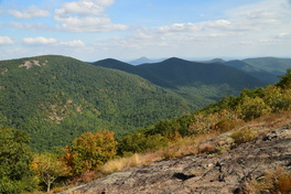
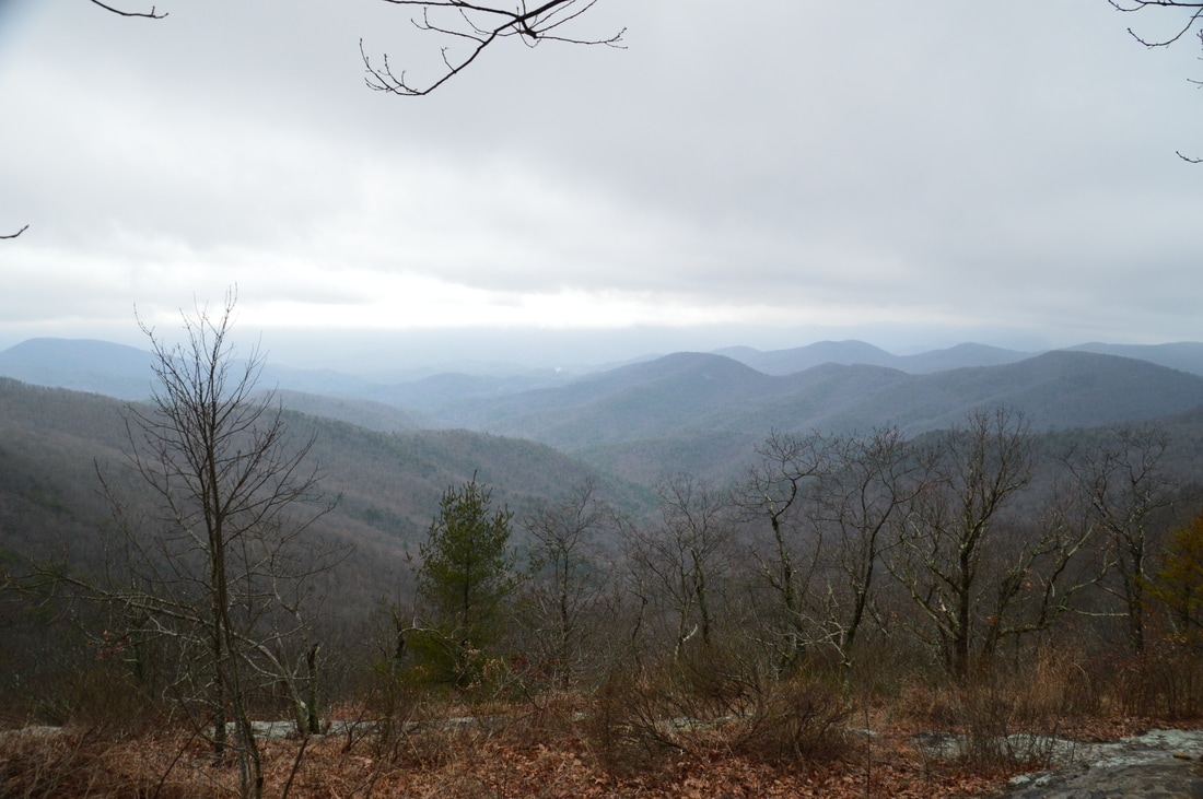
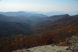
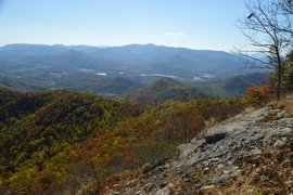
The Appalachian Trail in Georgia passes through some of the state's highest terrain, passing many different views. Some are very popular, such as Springer Mountain, Blood Mountain, and Tray Mountain. But the best and perhaps underrated view lies on Cowrock Mountain: a 3800-foot peak that lies in the Raven Cliffs Wilderness on the Blue Ridge Valley Divide. The Appalachian Trail passes right over the summit of the mountain, and just to the south of the AT, a pair of magnificent vistas await. To the east of Cowrock Mountain, the Appalachian Trail passes over a second mountain - Wildcat Mountain - where another rock slab gives additional views. Furthermore, a lesser-used access trail, known as the Logan Turnpike Trail, joins the AT between the two mountains via the picturesque Town Creek valley along the route of an old toll road. On this hike, you will use the Logan Turnpike Trail to reach the Appalachian Trail and visit both Cowrock Mountain and Wildcat Mountain. This hike occurred on Saturday, September 17th, 2016. My plan was to hike the Logan Turnpike Trail up to Tesnatee Gap, where it joins the Appalachian Trail. From there, I would first hike the AT northbound over Wildcat Mountain and to Hogpen Gap. Then, I would return to Tesnatee Gap, and I would hike the AT southbound to Cowrock Mountain. I would finish the hike by retracing my steps to Tesnatee Gap and down the Logan Turnpike Trail.
Traverse dozens of ravines, view fast streams and tumbling cascades, visit bluffs with excellent views of a a creek gorge - sounds like a perfect hike for your mountain vacation, right? Oh wait! It's right in Florida. The Econfina Creek segment of the Florida Trail is as unique as a hike could get in Florida, and you would barely be able to tell that you're in Florida, if the palmetto wasn't there. This spectacular section of the FT first descends into the Econfina Creek valley, passing some rapids on the creek, before following this waterway for many miles with a number of scenic sights along the way. This hike occurred on Friday, August 19th, 2016. My plan was to hike the Florida Trail out and back from Scott Road to Devil's Hole Recreation Area. Along the way, I would also hike the side trail to Trap Pond.
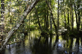
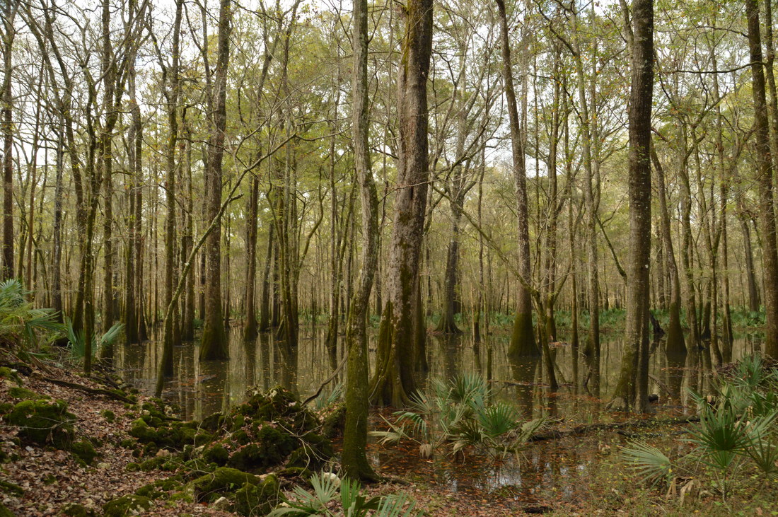
In many cases, a long hike through a swamp is a challenging hike that is not for the light-hearted. But the twelve-mile balloon loop through Bird Rookery Swamp is a mostly dry hike along old logging tramways that leads into the heart of the wild swamp without the hiker expending a lot of effort. On this hike, you will make a large loop through this remote corner of the Corkscrew Swamp Land and Water Trust, where alligators abound in great numbers, and hawks look down upon you from the dry canopy above the water. This hike occurred on Saturday, July 9th, 2016. My plan was to hike the Bird Rookery Swamp balloon loop counter-clockwise from the trailhead on Shady Hollow Boulevard.
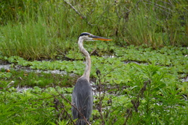
Anhingas. Egrets. Alligators. You'll see them all on this spectacular hike through a ranch-turned-preserve near the shores of Lake Hancock and just outside of the Lakeland city limits. Circle B Bar Reserve, renowned throughout Florida for its spectacular photo opportunities, attracts flocks of hikers every day to see the wildlife on its trails. The hike begins in a hammock with huge live oaks, before following the shore of Lake Hancock, where alligators shuffle into the water to the left and right. The hike then passes through wetlands where wading birds are in abundance (as well as more alligators) before passing an old windmill and returning to the trailhead. This hike occurred on Saturday, July 2nd, 2016. My plan was to make an outer loop through Circle B Bar Reserve's Trail System, as follows. First, I would take the Shady Oak Trail to Lake Hancock, where I would follow the Alligator Alley Trail past a lake observation area and along the shores of the lake. Then, after leaving the lake, I would take the Eagle Roost Trail along the southwest boundary of the preserve. There, I accidentally did the out and back along the Circle B Bar Connector Trail, although I didn't regret it. Lastly, I would take the Wading Bird Way to the Windmill Whisper Trail, before using the Treefrog Trail to finish the hike.
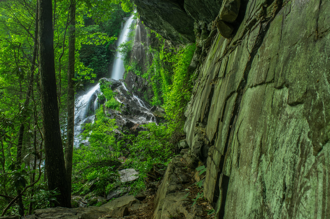
What are some of the tallest waterfalls in north Georgia? You probably have the names "Amicalola Falls" and "Anna Ruby Falls" somewhere in your head. But what about Cochrans Falls? There is a possibility that you haven't heard that name before, and for good reason. This 600-foot waterfall is only around 130 feet lower than Amicalola Falls, but it is one of the most secluded waterfalls in the entire state and has nowhere near the fame of its taller neighbor to the west. On this hike, you'll follow a jeep road into the depth of the Cochrans Creek valley, before taking a rugged and steep goat path to Cochrans Falls and the head of this remote and very scenic area. This hike occurred on Saturday, May 21st, 2016. My plan was to follow a jeep road from Blackhawk Road along Cochrans Creek. At the terminus of the road, I would take an unofficial trail that would scramble along the creek and past the numerous lower cascades and drops of Cochrans Falls all the way to the uppermost and highest drop. I returned to Cochrans Falls on Saturday, June 2nd, 2018, for better photos. This trail report has been updated with new access information, and a new photo gallery can be found below.
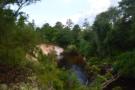
Located near the Apalachicola River, the Apalachicola Bluffs and Ravines Preserve protects one of the most unique habitats in Florida. The preserve has a number of steep ravines with streams flowing through them, and in fact, the preserve's hiking trail provides some of the biggest elevation changes to be found in the state. En route to the Apalachicola River, this hike passes through lush ravines as well as sandhill uplands with some longleaf pines. The highlight of the hike is at Alum Bluff. Positioned 135 feet above the Apalachicola River, this interesting geological formation provides a grand view of the river northward. The hike also makes a short loop through more ravines near the river and past additional sandy bluffs. This hike occurred on Sunday, April 24, 2016. My plan was to hike the Eden of Garden Trail out and back, At the far end of the trail, I would hike the short river loop counter-clockwise.

The coastal Florida Panhandle is well-known for its outstanding beaches. You have probably at least heard names such as Fort Walton Beach, Destin, and Panama City Beach. What most people don't know though is that not all of the beaches between Pensacola and Panama City are developed. A number of state parks, such as Topsail Hill State Park and St. Andrews State Park, are placed along the coast here to protect the fragile ecosystems that are found near the ocean. This part of Florida's coastline is home to fifteen coastal dune lakes - a very rare ecosystem that is found only in four other places: Oregon, Australia, Madagascar, and New Zealand. These lakes are one of the reasons that there is so much conserved land along the shoreline in Walton County. Out of the variety of state parks here, Topsail Hill State Park is the king of them all. This large park has several hiking trails that visit two dune lakes, a remote beach, and a landscape spotted with dunes of all shapes and sizes. This hike occurred on Tuesday, April 19, 2016. My plan was first to follow the paved Beach Tram Path to the Campbell Lake Bike Path, This is where I would take the south side of the Turpentine Trail past a view of Lake Campbell and then to the Deer Track Trail. I would follow the Deer Track Trail's south side to the Morris Lake Trail. After making a side trip to the beach, I would hike the Morris Lake Trail's loop counter-clockwise. Then, I would hike the Old Growth Trail, before hiking the Deer Track Trail's north side. I would finish the hike by following the north side of the Turpentine Trail.
You have probably heard about Cloudland Canyon. Cloudland Canyon State Park's Sitton Gulch and Daniel Creek's waterfalls are known very well throughout the hiking community. The park's West Rim Trail is also known quite well. However, many hikers are not aware of another hiking trail in the park - and one that is much more secluded: the Bear Creek Backcountry Trail. The Bear Creek Trail passes through the Bear Creek gorge and then cruises over hills in the eastern section of the park, before reaching a fantastic vista of Cloudland Canyon. Unfortunately, as of March 21, 2016, the Bear Creek Backcountry Trail is closed east of Bear Creek indefinitely. This hike occurred on Saturday, March 19th, 2016. My plan was to check out the "tourist overlook" of Cloudland Canyon near the trailhead. From there, I would hike the Overlook Trail to the Bear Creek Backcountry Trail. Then, I would hike the entire Bear Creek Backcountry Trail - my plan was to hike the loop section counter-clockwise and then return the same way. On my way back, I planned to hike the park's Backcountry Loop clockwise.
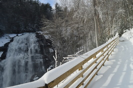 Gorges State Park is North Carolina's newest and westernmost state park, located in the area where Georgia, South Carolina, and North Carolina meet. The crown jewel of this still-developing park is the Rainbow Falls Trail, a normally easy hike that leads you to four spectacular waterfalls in the Horsepasture River gorge. On a day with 14-18 inches of fresh snow on the ground, however, the hike may not be so easy. This hike occurred on Saturday, January 23rd, 2016. My plan was to hike the Rainbow Falls Trail in the park out and back, visiting Stairstep Falls, Rainbow Falls, Turtleback Falls, and Drift Falls. I also planned to visit Raymond Fisher Pond and perhaps try some of the other short trails in the park. However, my plans were altered due to a heavy snowstorm that hit the region on the day before. All of western North Carolina got upwards of a half-foot of snow, with some areas (such as Gorges State Park) receiving as much as 18 inches. This caused Gorges State Park to be closed, and when I did this hike, I hiked the entrance road which added several miles more to my hike. Additionally, I was the first person to hike the Rainbow Falls Trail after snow, and with there being no previous footprints, it was a very slow and difficult hike. Thus, I was only able to hike the Rainbow Falls Trail to Rainbow Falls, Turtleback Falls, and Drift Falls.
|
About MeMark Oleg Ozboyd Dear readers: I have invested a tremendous amount of time and effort in this website and the Georgia Waterfalls Database the past five years. All of the work that has gone in keeping these websites updated with my latest trip reports has almost been like a full-time job. This has not allowed me to pick up a paid job to save up money for college, and therefore, I I've had to take out loans. If you find the information on this website interesting, helpful, or time-saving, you can say "thanks" and help me out by clicking the button above and making a contribution. I will be very grateful for any amount of support you give, as all of it will apply toward my college tuition. Thank you!

Coming in 2022-2023?
Other Hiking WebsitesMiles HikedYear 1: 540.0 Miles
Year 2: 552.3 Miles Year 3: 518.4 Miles Year 4: 482.4 Miles Year 5: 259.9 Miles Archives
March 2021
Categories
All
|
 RSS Feed