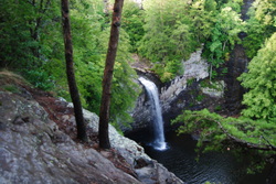
 The Fiery Gizzard Trail is one of the most beautiful and diverse trails in the state of Tennessee. Also, Backpacker Magazine lists it in the top 25 trails in the US. The nature in this part of the South Cumberland Plateau is beautiful. The Fiery Gizzard Trail starts on the southern edge of the city limits of Tracy City, and travels for 12 miles through rugged canyons in the Fiery Gizzard Creek watershed to Foster Falls Day Use Area. Foster Falls, a 60-foot single drop waterfall, makes for an exciting end to the trail. This hike occurred on Saturday, August 2nd, 2014. Starting the hike in the Foster Falls Day Use Area, I first checked out the Foster Falls Overlook. Then, I took the Fiery Gizzard Trail to pass above Foster Falls, and continued all the way to Laurel Gorge Overlook. My original plan was to stop here, but I decided to continue and make the rugged descent into the Laurel Branch Gorge. Then, I retraced my steps all the way back to the Climbers Access 2 to the Climbers Access Trail. This rugged trail descends down to Little Gizzard Creek and crosses just below Foster Falls on a swinging bridge, before ascending to the top of the rim and ending at the parking area.
0 Comments
 The North Carolina High Country is a beautiful area. It is part of the Pisgah National Forest, and part of it is also classified as the Shining Rock Wilderness. The NC High Country is where the mountain tops are bald, black balsam trees/forests are abundant, and steep, rushing streams descend into the valleys below to form some of the bigger rivers in the area. The drainages on the south side eventually end up in the Mills River, whereas the drainages on the north side end up in the Pigeon River. Yellowstone Prong is one of the major tributaries of the Mills River on the south side. Just below the bald summit of Black Balsam Mountain, Yellowstone Prong begins its journey southward towards the Mills River, and on the way, it passes through an outlier: a somewhat swampy, lush mountain meadow known as Graveyard Fields. This hike occurred on Saturday, July 19th, 2014, My original plan was to start at the Graveyard Fields Overlook on the Blue Ridge Parkway, hike down into Graveyard Fields via the Graveyard Fields Loop on the west side, and then take the spur trail to Upper Falls out and back. From there, I would take the Graveyard Ridge Connector to the Graveyard Ridge Trail, and the Graveyard Ridge Trail west to the Mountains-to-Sea Trail. Next, I would take the M-t-S to Black Balsam Road, and then the Art Loeb Trail over the bald summits of Black Balsam Mountain and Tennent Mountain to Ivestor Gap. From here, I would return by taking the Graveyard Ridge Trail southward back to the M-t-S. However, to add variety, I would turn left onto the M-t-S at the junction, and then return via the M-t-S Connector to Graveyard Fields Loop. Finally, I would return via the paved path out of Graveyard Fields to the parking area at the overlook. Sounds good enough, eh? Well, what actually happened was a little different. I got to a false gap what I thought was Ivestor Gap, and when I couldn't find Graveyard Ridge Trail, I took the old logging road that went to the left and connected with Ivestor Gap Trail. I followed Ivestor Gap Trail to Black Balsam Road, and finished the hike with 3 miles of roadwalk. This description will follow the actual route of my hike.
Appalachian Trail: Nantahala Outdoor Center (NOC) to Wesser Bald, Bryson City, North Carolina7/14/2014 
The Nantahala River is a premiere location for whitewater rafting and water slalom. The Nantahala Outdoor Center is situated right along the banks of the Nantahala's rushing waters, and on a good weekend, you can expect at least a hundred people here. Meanwhile, there's something for us hikers too. The Appalachian Trail passes through the NOC, crossing the busy US 74 and the Nantahala River. The Appalachian Trail offers a couple destinations in this area, including Cheoah Bald and Wesser Bald. While both are not easy to reach, both have ultimate rewarding views. This hike occurred on Friday, July 4th, 2014. My plan was to follow the Appalachian Trail from the NOC southward to the Jump-Up, and then even further to Wesser Bald and its fire tower. I would come back the same way.
 There's wilderness even in Alabama. In an area of low-elevation ridges and long valleys lies the Cheaha Widerness of the Talladega National Forest. While this is only a mini version of the mountains further north, the Talladega National Forest has numerous hiking trails, with many leading to grand views. While this wilderness is not as "wild" and rugged as the ones in Georgia and North Carolina, it still isn't an easy hike. This hike occurred on Saturday, May 17th, 2014. My plan was to drive up the Talladega Skyway to the Cheaha Wilderness Trailhead. I would hike the Cave Creek Trail to the Pinhoti Connector, follow the Pinhoti Connector to the Pinhoti Trail, and follow the Pinhoti Trail back to the parking lot. Along the way, I would stop at McDill Overlook for what was clearly the most beautiful view I have seen in Alabama, if not one of the most beautiful views I have seen in Alabama and Georgia combined.
Blue Ridge Parkway: Sam Knob - Flat Laurel Creek - Chestnut Bald Loop Trail, Brevard, North Carolina5/13/2014 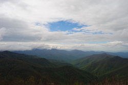 The Blue Ridge Parkway has some of the best hiking destinations in North Carolina, and this is only the second time I've been there (after Mount Pisgah three years ago). The Black Balsam/Sam Knob area is a small triangle between two wilderness areas and the Parkway. The views are grand from the whole hike, and many mountain tops are treeless. According to what I've heard, Sam Knob originally was only grass and rock, but it is being gradually covered up by brush and bushes. The views are incredible, nevertheless. This hike occurred on Saturday, May 10th, 2014. My plan was to take the Sam Knob trail from the Black Balsam Trailhead. At the junction with the Summit Trail, I planned taking the Summit Trail to the top of Sam Knob, and then go back down to the Sam Knob trail, and down to Flat Laurel Creek. After Flat Laurel Creek, I planned taking the Flat Laurel Creek Trail to the Little Sam Knob Trail, and from there, follow the Little Sam Knob Trail to the Mountains-to-Sea Trail. Finally, I planned finishing by taking the MtS to the Art Loeb Trail, and following the Art Loeb Trail to Black Balsam Road. The last part of the hike would be a road walk on Black Balsam Road.
Appalachian Trail: The Scales to Pine Mountain & Grayson Highlands State Park, Troutdale, Virginia4/22/2014 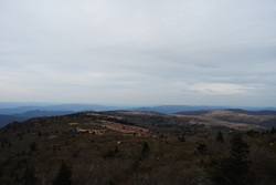 The Highlands of Virginia have a unique environment, and some of the best hiking in the Southeast. Apart from a few places in North Carolina's Pisgah National Forest, I don't know of any other places like the Mount Rogers National Recreation Area in Virginia. While Mount Rogers itself is not the most interesting mountain, the Grayson Highlands, Wilburn Ridge, and Pine Mountain - all that sits off the flank of Mount Rogers - provide incredible long-range views. This hike occurred on Saturday, April 19, 2014. My plan was to take the Appalachian Trail northbound from The Scales to The Pine Mountain Trail. From there, I planned hiking the Pine Mountain Trail to a point on the Appalachian Trail south of the original starting point, and follow the AT northbound to The Scales. I got to a late start in the late afternoon, due to the distance of the trail from my house, but I still thought I would finish it off shortly after dark. Not so fast, my friend.
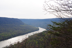 The Cumberland Trail is a state trail of Tennessee. It runs around 300 miles from its southern terminus at Signal Mountain, TN, to its northern terminus at Cumberland Gap, TN. It is not fully completed yet, but a lot of sections are open. It passes over the Cumberland Plateau of Tennessee, and is a very beautiful trail. I hope to hike many sections of it in the future. One of the most beautiful sections of it was the Tennessee River Gorge, my destination for this hike. This hike occurred on Saturday, April 5th, 2014. My plan was to hike the Cumberland Trail from its southern terminus at Signal Point Overlook to Edwards Point Overlook, and then return the same way.
 When you hear about the Black Mountains of Western North Carolina, Mt. Mitchell and the Craggy Gardens usually come to mind. However, there is something else besides that most people don't know about, especially those who live farther away. Below Mt. Mitchell and its 6000' brethren is the Asheville watershed, and to the east of the watershed is a small private community called Montreat. And what most people don't know, besides the ones who live there, is that there are 20 miles of hiking trails in Montreat, and a lot of them are strenuous. This hike occurred on Saturday, March 8th, 2014. My plans were to take the Graybeard Trail from the trailhead in Montreat up to Graybeard Mountain Overlook and descend back to Montreat via the West Ridge Trail on Seven Sisters Ridge and then down Big Piney Ridge Trail.
|
About MeMark Oleg Ozboyd Dear readers: I have invested a tremendous amount of time and effort in this website and the Georgia Waterfalls Database the past five years. All of the work that has gone in keeping these websites updated with my latest trip reports has almost been like a full-time job. This has not allowed me to pick up a paid job to save up money for college, and therefore, I I've had to take out loans. If you find the information on this website interesting, helpful, or time-saving, you can say "thanks" and help me out by clicking the button above and making a contribution. I will be very grateful for any amount of support you give, as all of it will apply toward my college tuition. Thank you!

Coming in 2022-2023?
Other Hiking WebsitesMiles HikedYear 1: 540.0 Miles
Year 2: 552.3 Miles Year 3: 518.4 Miles Year 4: 482.4 Miles Year 5: 259.9 Miles Archives
March 2021
Categories
All
|
 RSS Feed