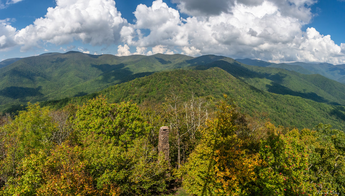
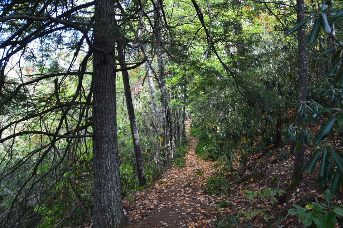
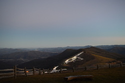
Twentymile is the southwesternmost major access point to Great Smoky Mountains National Park, and also one of the quietest. With nothing but a sleepy ranger station, small parking area, and trailhead, plus no significant destinations in close proximity, the Twentymile area remains little-visited compared to areas of the park like Cades Cove and Roaring Fork. Yet those who are willing to hike longer will find the Twentymile area quite interesting. The lengthy loop described here first follows the scenic cascades of Twentymile Creek before climbing to the Appalachian Trail and reaching the historic Shuckstack fire tower with its birds-eye view of Fontana Lake. The hike then heads deeper into the Smokies backcountry, traversing the Gregory Bald Trail - the eastern section of which near Doe Knob is one of the least-hiked trails in the park - before reaching the open grassy summit of Gregory Bald, featuring stunning 360-degree views. Even though both Shuckstack Tower and Gregory Bald can be reached via separate shorter hikes, it's hard to beat combining these two spectacular destinations into one large loop. This hike occurred on Saturday, October 6th, 2018. My plan was to initially hike the Twentymile Trail to the Appalachian Trail. After a side trip to Shuckstack, I would follow the AT north to Doe Knob. There, I'd pick up the Gregory Bald Trail and follow it all the way to Gregory Bald. On the other side of Gregory Bald, I would take the Wolf Ridge Trail and descend back to Twentymile. Although I completed this hike as a long day hike, you may find it more enjoyable as a two- or even three-day backpacking trip.
0 Comments
The Cataloochee Valley in Great Smoky Mountains National Park is a place where beauty and history mingle together. By the mid 1800s, there were several settlements in the valley, the remains of which we can still see today. The mountains around the Cataloochee Valley are home to areas of gorgeous old-growth forest, where tall trees tower proudly into the sky in areas that have never been logged. On this hike, you will first hike along the Caldwell Fork - a picturesque mountain stream - before taking the Boogerman Trail past some of the area's most remarkable trees, as well as a couple of significant historic points, including an old cemetery and an old stone wall. You will then follow the Big Fork Ridge Trail across a low ridge that separates the Caldwell Fork valley from the Cataloochee Valley, before concluding the hike along Cataloochee Road and seeing several more historical points of interest. If you're lucky, you might also spot the renowned Cataloochee elk. This hike occurred on Saturday, October 1st, 2016. My plan was to hike the Caldwell Fork Trail to the lower Boogerman Trail junction, from where I would follow the Boogerman Trail to its end farther up on the Caldwell Fork Trail. I would then take the Caldwell Fork Trail to the Big Fork Ridge Trail, which I would follow to Cataloochee Road. I would finish the hike by walking Cataloochee Road back to the trailhead.
Great Smoky Mountains National Park: Charlie's Bunion via Kephart Prong, Cherokee, North Carolina6/5/2015 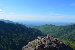
Kephart Prong, named after Horace Kephart, is one of the major tributaries of the Oconaluftee River. The headwaters of Kephart Prong are on the south side of Mount Kephart near the Appalachian Trail. This gorgeous balloon hike takes you from the confluence of Oconaluftee River and Kephart Prong deep into the Kephart Prong drainage, and then up a climb that will get your heart pumping all the way to Charlie's Bunion, a breathtaking vista of the Tennessee side of the Smokies and into the Tennessee River Valley. Your return route takes you past more views and even a couple waterfalls. This hike occurred on Saturday, May 23rd, 2015. My plan was to hike the Kephart Prong Trail to its terminus, and then continue on the Grassy Branch Trail. From there, I would take Dry Sluice Gap Trail to the Appalachian Trail, and take the Appalachian Trail over Mount Kephart and past Charlie's Bunion. I would continue by descending down Sweat Heifer Creek Trail and finishing the hike by going back down Kephart Prong Trail.
Mount LeConte is the most famous mountain in Great Smoky Mountains National Park. Being in the list of the top 25 highest peaks in the eastern US, it is also the tallest peak in the eastern US measured directly from its base near Gatlinburg. The mountain is home to a hikers lodge, accessed only by foot. The lodge provides amenities in all times of the year except winter. Due to the popularity of LeConte, five trails lead to the summit. If you have followed this blog for a little bit, you might have seen that I have already hiked to Mount LeConte via Alum Cave Trail. Unfortunately, I came to a fogged in overlook. This was my second attempt of seeing the views on Mount LeConte, with an even more challenging hike. And this time, due to my hiking partner not being in shape, the 4000-foot climb took considerably more time than expected. I arrived at the summit in the dark, but at least I was able to capture a good night picture of Pigeon Forge - even that wasn't possible last time. One day I'll set out on my third attempt to hike up to LeConte to see the views, and I know I won't fail that time. This hike occurred on February 28, 2015. My plan was to hike up to Mount LeConte via Rainbow Falls Trail, see the views from Cliff Tops, Myrtle Point, and Rocky Spur, and then return by Bullhead Trail.
 The Cataloochee area of the Great Smoky Mountains National Park is an overlooked and very scenic region. Cataloochee Divide marks the eastern boundary of GSMNP in this area, separating Cataloochee Valley and Maggie Valley. Cataloochee Divide Trail might be one of the most spectacular trail in the entire park, if hiked during winter. Views sprout in all directions. However, the section described here is a good hike even during summer, with amazing views from Hemphill Bald and Purchase Knob. Along the way back, take a minute to stop at and explore the Ferguson Cabin located just below Purchase Knob. This hike occurred on Thursday, December 25th, 2014. My plan was to park at the gate on Purchase Road, and then hike up Purchase Road to Purchase Knob. From there, I would pick up the Cataloochee Divide Trail and follow it past the The SWAG to Hemphill Bald. I would retrace my steps back, but instead of climbing back up Purchase Knob, I would shortcut it using the Ferguson Cabin Trail.
Great Smoky Mountains National Park: Mount LeConte via Alum Cave Trail, Gatlinburg, Tennessee11/3/2014  Mount LeConte is one of the most famous mountains in the Southeast. 3rd highest in the Great Smoky Mountains, it has as many as five access trails to the summit. I have done only one, but it is beautiful. Along the way up to LeConte, pass Arch Rock - an arch formed by water over the course of millions of years, and Alum Cave Bluffs - a huge rock overhang of Anakeesta Rock. Also, see the red squirrels, unique to the Southeast, that are found in this area. Near the summit, visit Mount LeConte Lodge and spend the night in the romantic-based lodge or cabins, or if you're like me, squeeze it all in a day hike. It's not that hard. This hike occurred on Saturday, October 18th, 2014. My plan was starting at the Alum Cave Bluffs Trailhead to follow the Alum Cave Trail all the way to the summit of Mt. LeConte. Then, I would visit Cliff Tops, Myrtle Point, and High Point. However, my plans did not include an excellent day changing to wind, fog, and drizzle.
 There's an assortment of waterfalls throughout the Smokies. Waterfalls aren't really my thing, but there are exceptions to that. Ramsey Cascades is the tallest waterfall in the park that is accessed by trail. Mill Creek Falls is slightly taller, but accessible by off-trail means only. Ramsey Cascades is around a hundred feet high, but what makes this waterfall more unusual than other is that it is not a "single drop waterfall", but rather, water cascading straight down a number of rock ledges. Not only is the destination of this hike rewarding, but the trail is too. On the trail, you will cross Ramsey Prong several times, as well as pass through an old-growth forest that contains some of the largest trees in the park. This hike occurred on Saturday, June 28, 2014. My plan was to follow the Ramsey Cascades Trail to Ramsey Cascades, and return the same way, since there were no other ways to return from the waterfall.
Great Smoky Mountains National Park: Gregory Bald via Gregory Ridge Trail, Townsend, Tennessee6/10/2014  The Great Smoky Mountains National Park in East Tennessee/West North Carolina is an incredible diversity of wildlife, not to speak of the incredible hiking opportunities. I've been to the Smokies a handful of times, and one of my favorite experiences was Chimney Tops on Newfound Gap Road. However, this is only the second time I've been to the Smokies before I started the blog where I am writing at. Gregory Bald is most famous for the flame azalea that blooms in early to mid June on its summit. In addition, Gregory Bald has a 2 acre grassy area at the top (hence the name "bald"), and the views are pretty much 360 degrees. My main problem on this hike was summer haze limiting the views somewhat, but it was still beautiful. This hike occurred on Saturday, June 7th, 2014. My plan was to hike the Gregory Ridge Trail from the end of Forge Creek Road to Rich Gap. Rich Gap is where the Appalachian Trail used to pass through before it was rerouted. From Rich Gap, my plan was to turn right onto the Gregory Bald Trail and follow it to the summit of Gregory Bald. I would return the same way to the trailhead.
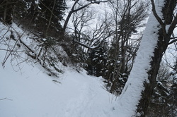
 On the southern side of the Great Smoky Mountains National Park, flows the Oconaluftee River. In the foothills of the Smokies, lies Smokemont Campground. There are many hiking opportunities in the campground area, and they become useful, when Newfound Gap Road closes during snow, leaving the Campground as the only option for hiking. The Smokemont Loop Trail, a combination of the Bradley Fork Trail, Smokemont Trail, and Benton Mackaye Trail. The trail follows Bradley Fork, which flows into the Oconaluftee, before climbing a high rudge, named Richland Mountain. I hiked this trail on Saturday, February 15th, 2014, after a moderate snowstorm. My plan was to start at the old church and hike the Smokemont Loop clockwise.
|
About MeMark Oleg Ozboyd Dear readers: I have invested a tremendous amount of time and effort in this website and the Georgia Waterfalls Database the past five years. All of the work that has gone in keeping these websites updated with my latest trip reports has almost been like a full-time job. This has not allowed me to pick up a paid job to save up money for college, and therefore, I I've had to take out loans. If you find the information on this website interesting, helpful, or time-saving, you can say "thanks" and help me out by clicking the button above and making a contribution. I will be very grateful for any amount of support you give, as all of it will apply toward my college tuition. Thank you!

Coming in 2022-2023?
Other Hiking WebsitesMiles HikedYear 1: 540.0 Miles
Year 2: 552.3 Miles Year 3: 518.4 Miles Year 4: 482.4 Miles Year 5: 259.9 Miles Archives
March 2021
Categories
All
|
 RSS Feed