HIKING THE APPALACHIANS AND BEYOND
  • Home
  • Trail Reports
    • Best Hikes
    • Hikes with Scenic Views
    • Hikes with Water Features
    • Alabama
    • Georgia
    • Florida
    • North Carolina
    • South Carolina
    • Tennessee
    • Vermont
    • Virginia
  • Map
  • Hike List
  • Testimonials
  • Resources
  • Contact Us
  • Southeast Nature Society
    • Our Team
  • Georgia Waterfalls Database

Chattahoochee National Forest: Iron Mountain - Conasauga River Loop, Chatsworth, Georgia

9/26/2017

2 Comments

 
Picture
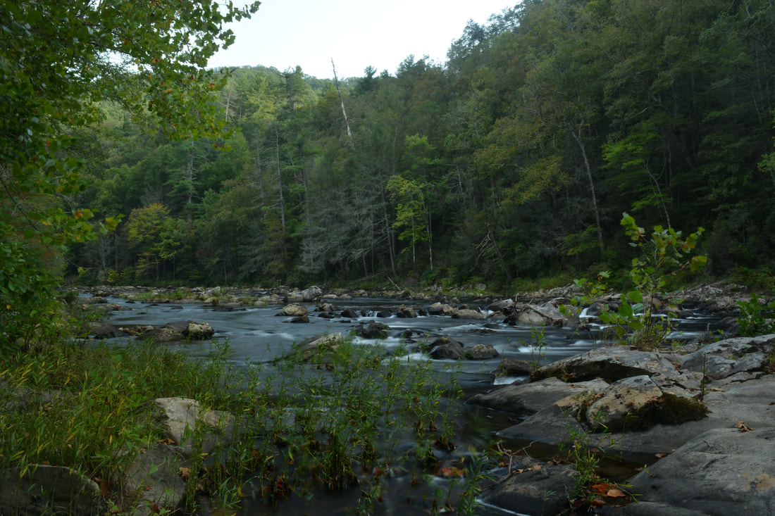
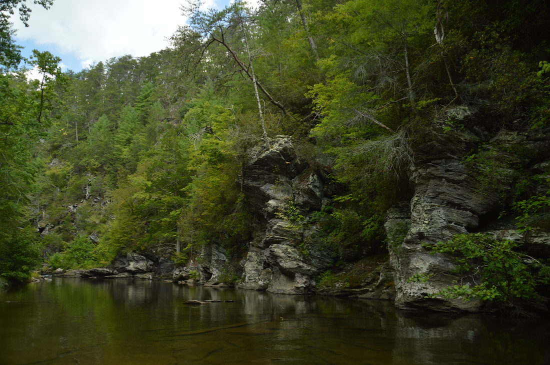
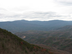
The Iron Mountain Loop is one of the less-used trails in the Cohutta Mountains. Most folks who visit the Conasauga River choose to hike the Conasauga River Trail #11 in the Cohutta Wilderness proper, well above the Jacks River confluence. On the other hand, the Iron Mountain Trail combines with Cherokee National Forest's Conasauga River Trail #61 to showcase a much broader and equally pristine section of the Conasauga River below the Jacks River confluence, where two mighty mountain rivers join into one. Although much of the Iron Mountain Trail is just a peaceful wooded walk across the slopes of Iron Mountain, a small vista at the halfway point offers a welcome break with a view of the West Cowpen Ridge that forms the Cohutta Wilderness boundary. The Iron Mountain Loop has only one downside: it gets a fair amount of equestrian traffic. This hike occurred on Saturday, September 23rd, 2017. My plan was to hike the Iron Mountain Loop clockwise by first following the Iron Mountain Trail from Cottonwood Patch Campground and then hiking the Conasauga River Trail to FS 221. The loop would be concluded with a short roadwalk along FS 221 and FS 16.


Read More
2 Comments

Chattahoochee National Forest: Lower Jigger Creek Falls, Chatsworth, Georgia

9/25/2017

0 Comments

 
Picture
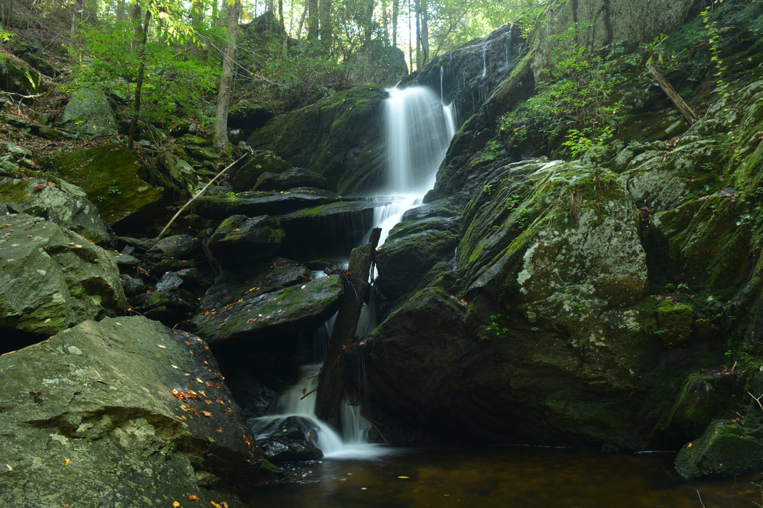
Lower Jigger Creek Falls is a very photogenic waterfall in Cohutta Wildlife Management Area that is easy to access yet off the radar. The falls is only about 25 feet high but consists of a scenic free-fall and steep cascade amidst large boulders and jagged rock outcrops. Lower Jigger Creek Falls' setting is striking thanks to the sizable boulder field that begins at the waterfall and continues for some distance downstream. The short hike to the falls follows distinct paths with exclusively easy grades from East Cowpen Road. This hike occurred on Saturday, September 23rd, 2017. My plan was to hike out and back to Lower Jigger Creek Falls from East Cowpen Road. 


Read More
0 Comments

Cohutta Wilderness: Panther Creek Falls via Hickory Creek - Conasauga River - Panther Creek - East Cowpen Loop, Chatsworth, Georgia

9/21/2017

0 Comments

 
Picture
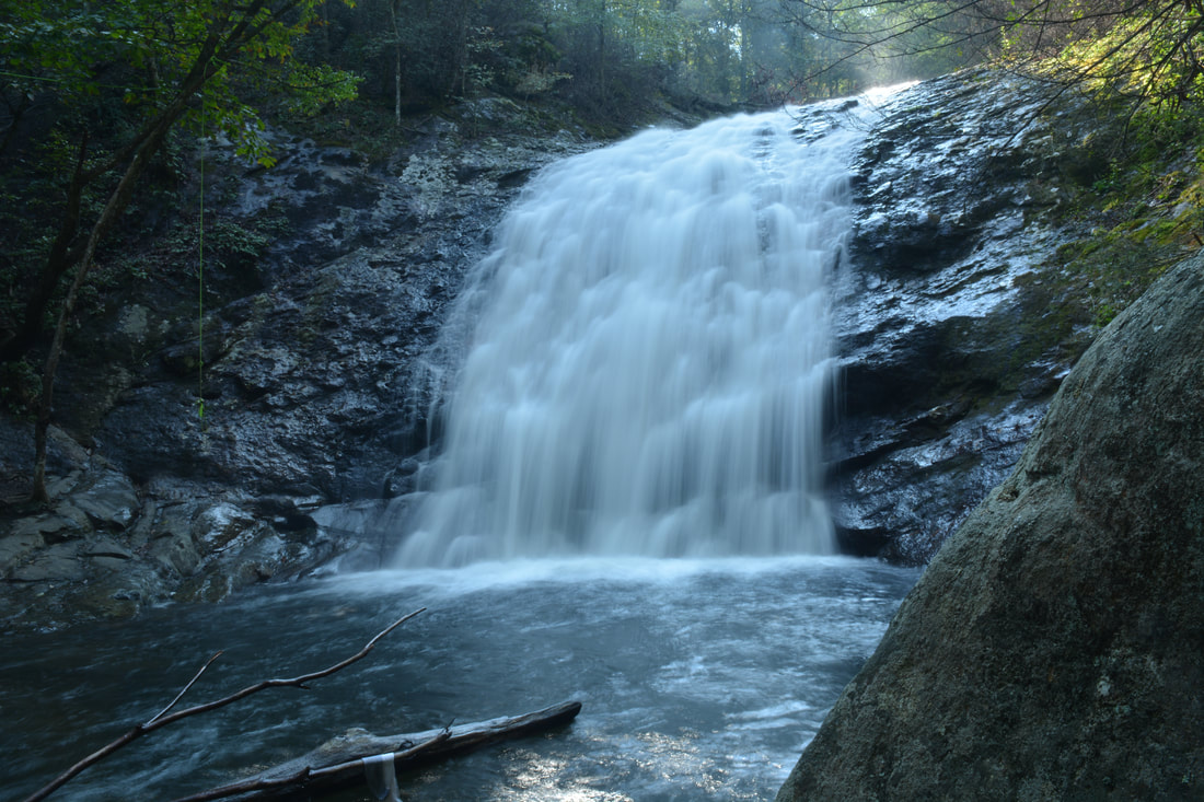
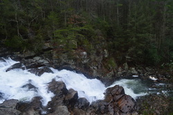
Panther Creek Falls is one of two well-known waterfalls in the Cohutta Wilderness. During high flow, the falls is quite beautiful as Panther Creek slides 80 feet down a massive cliff. But the many different wilderness approaches to Panther Creek Falls are at least as great as the falls itself. The Hickory Creek Loop approach to Panther Creek Falls is likely the most difficult and least-used, but the spectacular wilderness experience on remote trails is well worth it. On this strenuous loop hike, you'll follow the Conasauga River and cross it twice, scramble through a steep and unique boulder field, visit Panther Creek Falls and the great vista atop it, and gain over 3500 feet in elevation. If you don't feel like completing the Hickory Creek Loop in a long day hike, numerous superb campsites will allow you to split the loop into as many days as you feel comfortable. This hike occurred on Saturday, September 16th, 2017. My plan was to hike the Hickory Creek Loop counter-clockwise from the end of East Cowpen Road by following the Hickory Creek Trail, Conasauga River Trail, Panther Creek Trail, and East Cowpen Trail. 


Read More
0 Comments

Chattahoochee National Forest: Mill Creek Falls Trail, Chatsworth, Georgia

9/20/2017

1 Comment

 
Picture
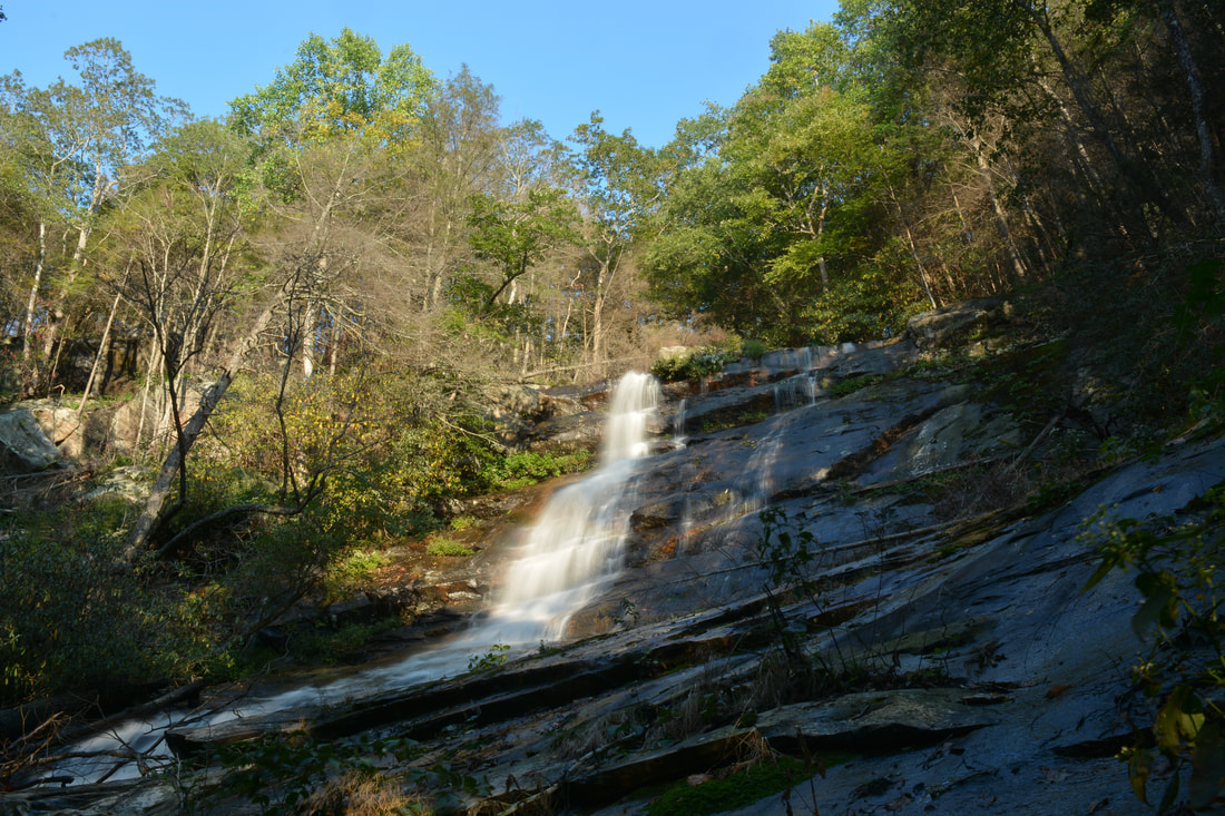
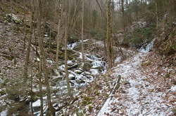
Mill Creek is one of the most scenic small streams in the Cohutta Mountains of Northwest Georgia. In a little more than a half-mile, the creek comes over four waterfalls and many smaller cascades, and an easy unofficial trail follows the creek with access to all of the gorgeous scenery. The third and largest waterfall, in particular, is a beautiful steep slide that drops over 30 feet into a sparkling pool. The last part of the trail is a steep scramble to the base of the third falls, but it still definitely is doable to most folks and well worth the effort. This hike occurred on Saturday, September 16th, 2017. My plan was to hike the Mill Creek Trail out and back from Hickey Gap Campground past the 1st Falls and 2nd Falls to the 3rd Falls on Mill Creek. I would also make a short creek scramble to the 4th Falls from the 3rd Falls. 


Read More
1 Comment

Cohutta Wilderness: Horseshoe Bend Trail and Jacks River Trail to Jacks River Falls and Alaculsy Trailhead, Chatsworth, Georgia

11/30/2016

1 Comment

 
Picture
Looking at a topographic map of the Jacks River area, one can easily make out the iconic Horseshoe Bend in the river, where the land sticks out in the form of a horseshoe. The Jacks River Trail is a trail that is over a dozen miles long and has over forty river fords, as it follows the Jacks River for much of its length and crisscrosses it numerous times. This trail provides the easiest access into the beautiful stretch of the Jacks River at Horseshoe Bend. A lesser-used trail known as the Horseshoe Bend Trail can be used to accessed the area as well, and there's also a catch: it passes mere feet away from one of the most beautiful vistas in the Cohutta Mountains. On this hike, you'll first hike through upland areas south of the Jacks River, passing the spectacular Horseshoe Bend vista, before hiking through the scenic Jacks River Gorge to Jacks River Falls. This hike occurred on Saturday, September 3rd, 2016. My plan was to follow the Horseshoe Bend Trail from FS Road 51 to the Jacks River Trail. From there, I would hike out and back along the Jacks River Trail upstream to Jacks River Falls, and then, I would follow the Jacks River Trail downstream to the Alaculsy Trailhead. I arranged to have two cars for this point-to-point hike: one car was placed at the Horseshoe Bend Trailhead and another car was placed at the Alaculsy Jacks River Trailhead. 


Read More
1 Comment

Cohutta Wilderness: Jacks River Falls via Rice Camp Loop, Chatsworth, Georgia

4/4/2015

7 Comments

 
Picture
The Jacks River is a turbulent waterway that is the main linear focus of the northern Cohutta Wilderness. The Jacks River Trail travels through the wilderness from the river's headwaters near Dally Gap to the wilderness boundary and the place where Jacks River flows into the Conasauga River in Alaculsy Valley. With 42 fords, the trail is the wettest trail in the Cohutta Wilderness, but also the most scenic, passing through a gorge and past a large waterfall. On this hike, you'll have a chance to experience two fords of the Jacks River, as well as see Jacks River Falls - one of the most powerful waterfalls in Georgia. This hike occurred on Saturday, March 14th, 2015. My plan was to hike the Rice Camp Loop clockwise. I would first take the Rice Camp Trail to the Jacks River. From there, I would take the Jacks River Trail upstream, stopping by Jacks River Falls long the way. Next, I would take the Hickory Ridge Trail and follow it to its terminus at the East Cowpen Trail near Buckeye Mountain. I would finish by taking the East Cowpen Trail downhill back to the trailhead.


Read More
7 Comments

Fort Mountain State Park: Bike/Hike Trails #301 and #303, Chatsworth, Georgia

3/8/2015

3 Comments

 
Picture
Fort Mountain State Park has one of the most impressive trail systems in Georgia's state parks. The western section of the park has over a dozen talc mines. While these mines are closed to the public, they can be viewed from the extensive trail system in that area. In addition, the park's two main streams, Mill Creek and Goldmine Creek, both have sets of picturesque cascades and waterfalls. The light snow cover along with ice from the preceding week's cold blast made this hike an excellent one. This hike occurred on February 21st, 2015. My plan was to hike Bike/Hike Trail #301 counter-clockwise. Old Fort Road, the road leading to the trailhead, was closed due to ice and snow, so I ended up also hiking Bike/Hike Trail #303 from Fort Mountain Lake Trailhead. 


Read More
3 Comments

Cohutta Wilderness: Beech Bottoms Trail to Jacks River Falls, Chatsworth, Georgia

2/6/2015

5 Comments

 
Picture
The Jacks River is the second largest waterway in the combined Cohutta-Big Frog Wilderness. While maybe not the largest, it is probably the most turbulent, with a large gorge and a waterfall along its course. Jacks River Falls is the highest and most powerful waterfall in the combined wilderness. Most routes require at least one deep ford of Jacks River to reach the falls. However, Beech Bottoms Trail is a good winter alternative, being the only relatively "dry" route to the falls. The only crossings will be over Beech Bottoms Creek, which may still be problematic in high water levels. This hike occurred on January 3rd, 2015. My plan was to hike the Beech Bottoms Trail southward to Jacks River Trail. Then, I would take the Jacks River Trail west to Jacks River Falls. I would return the same way. 


Read More
5 Comments

Fort Mountain State Park: Stone Tower Loop and Gahuti Trail, Chatsworth, Georgia

1/6/2015

1 Comment

 
Picture
Fort Mountain is one of the most prominent features in northwestern Georgia. While its elevation is low relative to the Cohutta Mountains just to the north, the steep drop-off of the mountain can be recognized from dozens of miles away. The mountain is pretty significant historically. The very summit of Fort Mountain is marked by a CCC Stone Tower, which is currently closed to the public. Just below the summit, an 800-foot wall of mysterious origin follows the south slope of the mountain. The Gahuti Trail takes you farther from the summit of the mountain into more remote regions, where you can find waterfalls on Goldmine Creek. This hike occurred on Saturday, November 29th, 2014. My plan was to start at the Cool Springs Trailhead, and after checking out the Cool Springs Overlook, to follow the Gahuti to the Stone Tower Loop. After hiking the Stone Tower Loop, I would leave the crowded sections of the park and hike the Gahuti Loop counter-clockwise. If time would remain, I would take the #301 Bike Trail down the mountain to see some of the lower waterfalls on Goldmine Creek.


Read More
1 Comment

Chattahoochee National Forest: Grassy Mountain Fire Tower and Songbird Trail, Chatsworth, Georgia

9/23/2014

0 Comments

 
Picture
The Cohutta Mountains of Northwest Georgia are some of the oldest in world, and have many great hiking trails. the southwestern end of the Cohuttas is marked by Grassy Mountain, which houses a fire tower from the last century. Below the fire tower, Conasauga Lake, the highest elevation lake in Georgia, has a campground and some hiking trails. This hike occurred on Saturday, September 6th, 2014. My plan was to approach the Grassy Mountain Fire Tower by the closed forest road leading to it. I would return by the Tower Trail and Songbird Trail. 


Read More
0 Comments

    About Me

    Mark Oleg Ozboyd
    I'm an avid outdoor explorer and a hobbyist landscape photographer. I'm 21 years old and have been hiking since 2011. Originally based out of Atlanta, Georgia, I started out by occasionally hiking short trails throughout well-known Georgia State Parks. During 2012 and 2013, I began to expand my trips into adjacent states, as well as into the wilder National Forest areas rather than just State Parks. Throughout the years that followed, as I slowly ran out of popular hiking trails in my area, I began to search for and hike in more seldom-visited areas. Today, you can find me out in the woods every weekend, whether it's on an official trail or bushwhacking through cross-country terrain without any paths. I now attend Washington & Lee University and am exploring Virginia and West Virginia. My other hobbies include chess, science, old music, and meteorology. I have 3 years of amateur weather forecasting experience, having studied a lot of meteorology basics over the years. I am also a student at European School of Music where I learned that music and nature have a lot in common. Listening to good music inspires me to capture nature's beauty on the camera in different aspects that also make me recall many beautiful music pieces that I've heard.​


    Dear readers: I have invested a tremendous amount of time and effort in this website and the Georgia Waterfalls Database the past five years. All of the work that has gone in keeping these websites updated with my latest trip reports has almost been like a full-time job. This has not allowed me to pick up a paid job to save up money for college, and therefore, I I've had to take out loans. If you find the information on this website interesting, helpful, or time-saving, you can say "thanks" and help me out by clicking the button above and making a contribution. I will be very grateful for any amount of support you give, as all of it will apply toward my college tuition. Thank you! 

    Enter your email address to subscribe for trail reports:

    Delivered by FeedBurner


    Picture
    Coming in 2022-2023?

    Other Hiking Websites

    DWHike's Adventures
    Florida's Natural Wonders
    Florida Trailblazer
    Meanderthals
    Mountain Images
    by Bernie Boyer

    North Carolina Waterfalls with
    ​Kevin Adams
    Take-a-Hike!
    Tennessee Landforms
    Waterfall Page
    Waterfall Adventurer
    Zach's Mild Adventures

    Miles Hiked

    Year 1: 540.0 Miles
    Year 2: 552.3 Miles
    ​Year 3: 518.4 Miles
    Year 4: 482.4 Miles
    Year 5: 259.9 Miles

    Archives

    March 2021
    February 2021
    January 2021
    November 2019
    October 2019
    September 2019
    August 2019
    July 2019
    June 2019
    February 2019
    January 2019
    December 2018
    November 2018
    October 2018
    August 2018
    July 2018
    June 2018
    May 2018
    April 2018
    March 2018
    February 2018
    January 2018
    December 2017
    November 2017
    October 2017
    September 2017
    August 2017
    July 2017
    June 2017
    May 2017
    April 2017
    March 2017
    February 2017
    January 2017
    December 2016
    November 2016
    October 2016
    September 2016
    August 2016
    June 2016
    May 2016
    April 2016
    March 2016
    January 2016
    December 2015
    November 2015
    October 2015
    September 2015
    August 2015
    July 2015
    June 2015
    May 2015
    April 2015
    March 2015
    February 2015
    January 2015
    December 2014
    November 2014
    October 2014
    September 2014
    August 2014
    July 2014
    June 2014
    May 2014
    April 2014
    March 2014
    February 2014

    Categories

    All
    Adel
    Adirondack Park
    Alabama
    Alfred A. Ring Park
    Allegheny Trail
    Amicalola Falls State Park
    Anniston Area
    Apalachicola Bluffs And Ravines Preserve
    Apalachicola National Forest
    Apalachicola/Port St. Joe Area
    Apopka
    Appalachian Trail
    Appling
    Art Loeb Trail
    Aska Trail System
    Bakersville
    Balm-Boyette Scrub Preserve
    Balsam Lake Recreation Area
    Bankhead National Forest
    Bartow County Parks
    Bartram Trail
    Basinger
    Beersheba Springs
    Benton
    Benton Mackaye Trail
    Berry College Trail System
    Best Hike
    Big South Fork National Recreation Area
    Black Bear Wilderness
    Black Rock Mountain State Park
    Blairsville
    Blakely
    Blood Mountain Wilderness
    Blowing Rock
    Blue Ridge
    Blue Ridge Parkway
    Boone
    Bradenton
    Bradenton Beach
    Brasstown Bald
    Brasstown Wilderness
    Brevard
    Bryson City
    Buchanan
    Bucks Pocket State Park
    Bulow Creek State Park
    Bulow Plantation Ruins State Park
    Caesars Head State Park
    Caladesi Island State Park
    Calhoun
    Camel's Hump State Park
    Cashiers
    Caspersen Beach Park
    Catfish Creek State Park
    Caves
    CC Putnam State Forest
    Cedar Point Environmental Park
    Chatsworth
    Chattahoochee National Forest
    Chattanooga
    Chattanooga Valley
    Chattooga National Wild And Scenic River
    Cheaha Wilderness
    Cherohala Skyway
    Cherokee
    Cherokee National Forest
    Chiefland Area
    Chillhowee Recreation Area
    Chipley
    Chunky Gal Trail
    Circle B Bar Reserve
    Citico Creek Wilderness
    Citrus Wildlife Management Area
    Clarkesville
    Clayton
    Cleevland
    Cleveland
    Cloudland Canyon State Park
    Cohutta Wilderness
    Collier-Seminole State Park
    Cordele
    Cornelia
    Covington
    Crestview Area
    Crew-land-and-water-trust
    Cullowhee
    Cumberland Trail
    Dahlonega
    Dalton
    Dawson Forest Wildlife Management Area
    Dawsonville
    Dayton
    De Soto National Memorial
    DeSoto State Park
    Dillard
    Double Springs
    Ducktown
    Duncan Ridge Trail
    Dunlap
    Eagle's Rest Park
    Eastpoint
    Econfina Creek Wildife Management Area
    Eglin Air Force Base
    Elizabethton
    Elkins
    Elk Knob Game Lands
    Elk Park
    Ellicott Rock Wilderness
    Ellijay
    Emerson Point Preserve
    Englewood Area
    Enota Retreat
    Erwin
    Falling Waters State Park
    Fayetteville
    Fires Creek Recreation Area
    Fire Tower
    Flint River
    Florence Area
    Florida
    Florida Caverns State Park
    Florida Trail
    Foothills Trail
    Fort Mountain State Park
    Fort Myers Area
    Fort Payne
    Fort Payne Area
    Fort Yargo State Park
    Franklin
    Franklin Delano Roosevelt State Park
    Franklin-Marion State Forest
    Frozen Head State Park
    Gainesville
    Gainesville Area
    Gatlinburg
    George Washington National Forest
    Georgia
    Georgia Veterans Memorial State Park
    Glasgow
    Gorges State Park
    Grandfather Mountain State Park
    Great Smoky Mountains National Park
    Greeneville
    Green River Game Lands
    Gruetli-Laager
    Grundy Forest State Natural Area
    GTM Reserve
    Guana River Wildlife Management Area
    Hayesville
    Helen
    Hiawassee
    High Falls State Park
    Highlands
    Highlands Scenic Highway
    Hillsborough River State Park
    Hinson Conservation & Recreation Area
    Historic Sites
    Honeymoon Island State Park
    Hot Springs
    Huntington
    Inverness Area
    Jackson
    Jasper
    Jefferson National Forest
    Joan M. Durante Park
    Jonathan Dickinson State Park
    Jones Gap State Park
    Joyce Kilmer Slickrock Wilderness
    Joyce Kilmer - Slickrock Wilderness
    Juniper Prairie Wilderness
    Kelly Park
    Keown Falls Recreation Area
    Kolomoki Mounds State Park
    LaFayette
    Lake City Area
    Lake George Wild Forest
    Lake June-in-Winter State Park
    Lakeland Area
    Lake Placid
    Lake Russell Wildlife Management Area
    Lake Wales Ridge State Forest
    Laurel Fork North Wilderness
    Leffis Key Preserve
    Leon Sinks Geological Area
    Lexington
    Lineville
    Linville
    Linville Gorge Wilderness
    Lithia Springs
    Little Frog Wilderness
    Little Manatee River State Park
    Little River Canyon National Preserve
    Longboat Key
    Long Trail
    Lookout Mountain
    Lookout Mountain Battlefield
    Lovingston
    Lula Lake Land Trust
    Lumpkin
    Maggie Valley
    Manatee Springs State Park
    Marianna Area
    Mark Trail Wilderness
    Marlinton
    Mccaysville
    McMinville
    Mentone
    Middlesex
    Mistletoe State Park
    Monongahela National Forest
    Montreat
    Mountain Bridge Wilderness Area
    Mountain City
    Mountains To Sea Trail
    Mountains-to-Sea Trail
    Mount Rogers National Recreation Area
    Myakka River State Park
    Myron B. Hodge City Park
    Nantahala National Forest
    Naples
    Naples Area
    Natural Bridge State Park
    Neal Preserve
    New Castle
    Newport
    New River Gorge National Park
    New York
    North Carolina
    Ocala Area
    Ocala National Forest
    Ocean-to-Lake Trail
    Oconee State Park
    Oconee Station Historic Site
    Okaloacoochee Slough State Forest
    Oldsmar
    Oneida
    Orlando Area
    Ormond Beach
    Oscar Scherer State Park
    Oxford
    Palatka
    Palmetto Trail
    Panama City Area
    Panthertown Valley
    Parrish
    Paynes Creek Historic State Park
    Peaks Of Otter Recreation Area
    Pigeon Crockford Mountain Wildlife Management Area
    Pigeon-Crockford Mountain Wildlife Management Area
    Pigeon-Crockford Wildlife Management Area
    Pine Mountain
    Pinhoti Trail
    Pinnacle Park
    Pisgah Civitan Park
    Pisgah National Forest
    Pittman Center
    Pond Mountain Wilderness
    Ponds/Lakes
    Prentice Cooper State Forest
    Providence Canyon State Park
    Pumpkintown
    Quick Point Nature Preserve
    Raven Cliffs Wilderness
    Reed Bingham State Park
    Reliance
    Rice Creek Conservation Area
    Riverview Pointe Preserve
    Robbinsville
    Robinson Preserve
    Rock Creek Gorge Scenic Area
    Rock Island State Park
    Rome
    Rosman
    Sale Creek
    Salem
    Salt Springs
    Saluda
    Santa Rosa Beach
    Sarasota
    Sarasota Area
    Savage Gulf State Natural Area
    Scenic Views
    Scottsboro Area
    Sebring Area
    Sewanee
    Sheltowee Trace Trail
    Shining Rock Wilderness
    Signal Mountain
    Sipsey Wilderness
    Sky Valley
    Smithgall Woods State Park
    Snowbird Backcountry Area
    Soddy Daisy
    Soddy-Daisy
    Sopchoppy
    South Carolina
    South Cumberland State Park
    Southeastern Cave Conservancy
    Southern Nantahala Wilderness
    Sparta
    Sprewell Bluff Park
    Spring City
    Spring Hill
    Springs
    Spruce Pine
    Standing Indian Backcountry Area
    St. Augustine
    St. George Island State Park
    St. Joseph Bay State Buffer Preserve
    St. Marks Area
    St. Marks National Wildlife Refuge
    Stone Mountain
    Stone Mountain Park
    Suches
    Sumatra
    Sumter National Forest
    Suwannee River
    Swallow Creek Wildlife Management Area
    Sweetwater Creek State Park
    Sylva
    Talladega National Forest
    Tallahassee Area
    Tallulah Falls
    Tallulah Gorge State Park
    Tampa Bay Area
    Tate City
    Tate's Hell State Forest
    Tea Creek Wildlife Management Area
    Tellico Plains
    Tennessee
    Thomaston
    Toccoa
    Topsail Hill State Park
    Torreya State Park
    Townsend
    Tracy City
    Tray Mountain Wilderness
    Trenton
    Triple Creek Preserve
    Troutdale
    Unaka Mountain Wilderness
    Upper Tampa Bay County Park
    Venice
    Vermont
    Virgin Falls State Natural Area
    Virginia
    Virginia Outdoors Foundation
    Vogel State Park
    Wakulla Springs State Park
    Waleska
    Walhalla
    Wartburg
    Water Features
    Waynesville
    Weedon Island Preserve
    Weeki Wachee Preserve
    Wekiwa Springs State Park
    West Palm Beach Area
    West Virginia
    Whitehall
    White Springs
    Winder
    Withlacoochee State Forest
    Young Harris

    RSS Feed

TRAIL REPORTS

Hikes in Alabama
​Hikes in Florida
Hikes in Georgia
Hikes in North Carolina
Hikes in South Carolina
Hikes in Tennessee
Hikes in Virginia

Hiking Resources

Alabama Resources
​
Florida Resources
Georgia Resources
North Carolina Resources
​South Carolina Resources
​
Tennessee Resources

Other

Contact
Map of Hikes
Alphabetical List of Hikes
Southeast Nature Society
© COPYRIGHT 2014-2018
​ALL RIGHTS RESERVED.
Important: I disclaim any responsibility for any damage or personal injury that may occur as a result of the activities and information found on this website. All outdoor activities, especially off-trail hiking, are done at your own risk. Never hike or head into that area that may be above your fitness or experience level.
  • Home
  • Trail Reports
    • Best Hikes
    • Hikes with Scenic Views
    • Hikes with Water Features
    • Alabama
    • Georgia
    • Florida
    • North Carolina
    • South Carolina
    • Tennessee
    • Vermont
    • Virginia
  • Map
  • Hike List
  • Testimonials
  • Resources
  • Contact Us
  • Southeast Nature Society
    • Our Team
  • Georgia Waterfalls Database