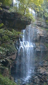
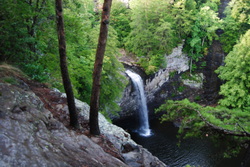
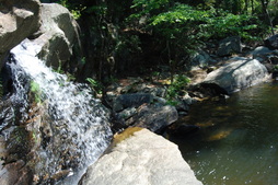
Virgin Falls State Natural Area: Virgin Falls Trail and Caney Fork River Trail, Sparta, Tennessee8/29/2014  The Caney Fork River's sources are in the northern Cumberland Plateau. On its way to the Tennesee River, it cuts a dramatic gorge known as "Scotts Gulf" near Sparta, TN. The Bridgestone-Firestone Centennial Wilderness protects Scotts Gulf, and an additional tract of land is Virgin Falls State Natural Area. Virgin Falls State Natural Area protects a number of features, with the key feature known as Virgin Falls. The 110-foot high cataract is very rare - it flows out of a cave and disappears int a pit in the ground that leads into an underground cave system. Additionally, Virgin Falls State Natural Area encompasses two more, smaller waterfalls, and a great overlook of Scott's Gulf itself. This hike occurred on Saturday, August 9, 2014. My plan was to do a loop hike with the Virgin Falls Trail, Caney Fork River Trail, and a Connector leading back up to Scott's Gulf Road. Also, on the way, I would check out Sheep Cave, Big Laurel Falls, Big Branch Falls, and Martha's Pretty Point Overlook. However, the plan had to be abandoned as the Caney Fork River Trail's condition deteriorated rapidly. The result was an out and back hike on Virgin Falls Trail and an extension along the Caney Fork River Trail.
0 Comments
 The Fiery Gizzard Trail is one of the most beautiful and diverse trails in the state of Tennessee. Also, Backpacker Magazine lists it in the top 25 trails in the US. The nature in this part of the South Cumberland Plateau is beautiful. The Fiery Gizzard Trail starts on the southern edge of the city limits of Tracy City, and travels for 12 miles through rugged canyons in the Fiery Gizzard Creek watershed to Foster Falls Day Use Area. Foster Falls, a 60-foot single drop waterfall, makes for an exciting end to the trail. This hike occurred on Saturday, August 2nd, 2014. Starting the hike in the Foster Falls Day Use Area, I first checked out the Foster Falls Overlook. Then, I took the Fiery Gizzard Trail to pass above Foster Falls, and continued all the way to Laurel Gorge Overlook. My original plan was to stop here, but I decided to continue and make the rugged descent into the Laurel Branch Gorge. Then, I retraced my steps all the way back to the Climbers Access 2 to the Climbers Access Trail. This rugged trail descends down to Little Gizzard Creek and crosses just below Foster Falls on a swinging bridge, before ascending to the top of the rim and ending at the parking area.  In a normal state park, or recreation area for that matter, you have a chance to visit it every day, whenever you want. In Lula Lake Land Trust, two days is how many days you have a chance to visit per month. Just two. Lula Lake Land Trust is a nonprofit organization that bought a small area of land of Lula Lake Road to protect Rock Creek and its watershed. Thank you for buying it. The area of land, while small, houses two waterfalls, a gorge, and a ridge with spectacular views. This is one of the best hikes in northwest Georgia, besides Cloudland Canyon State Park's trail system. The only major con is that much of the hike is on old roads, perhaps the only reason I won't classify it as a Best Hike. This hike occurred on Saturday, August 2nd, 2014. My plan was to hike down the Lula Lake Entrance Road from the parking area to the Old Railroad Grade Trail. From there, I would follow the Railroad Grade Trail past Lula Lake Falls to Lula Falls Trail. I would follow Lula Falls Trail to the base of the falls, and then return back and continue down the Old Railroad Grade Trail to the High Adventure Trail. From there, I would follow the High Adventure Trail to great views at the top of Eagle Cliff, and then take the Middle Road Trail down to the chestnut orchards. Next, from the Middle Road Trail, I would take the Turkey Trail to the Overbird Trail, the Overbird Trail back to the Middle Road Trail, and finally, the Middle Road Trail to the Middle Road Cutoff Trail, which would take me back to the parking area. 
Cheaha Wilderness is the first of two wilderness areas in Alabama's Talladega National Forest. The wilderness is named after Alabama's highest peak, Cheaha Mountain. The wilderness is located in the southern half of Talladega National Forest, and is shaped as a thin rectangle east of Highway 281. A large trail systems lies across the wilderness and surrounding areas, making it easy to travel through different portions of the wilderness. One of the trails in particular, Chinnabee Silent Trail, starts at Lake Chinnabee in the western end of Talladega National Forest, and meanders a half dozen miles through the area, with the last 2 in the Cheaha Wilderness, before terminating at the Pinhoti Trail. This hike occurred on Saturday, July 26th, 2014. My plan was to hike the entire Chinnabee Silent Trail from west to east, and return the same way.
|
About MeMark Oleg Ozboyd Dear readers: I have invested a tremendous amount of time and effort in this website and the Georgia Waterfalls Database the past five years. All of the work that has gone in keeping these websites updated with my latest trip reports has almost been like a full-time job. This has not allowed me to pick up a paid job to save up money for college, and therefore, I I've had to take out loans. If you find the information on this website interesting, helpful, or time-saving, you can say "thanks" and help me out by clicking the button above and making a contribution. I will be very grateful for any amount of support you give, as all of it will apply toward my college tuition. Thank you!
Coming in 2022-2023?
Other Hiking WebsitesMiles HikedYear 1: 540.0 Miles
Year 2: 552.3 Miles Year 3: 518.4 Miles Year 4: 482.4 Miles Year 5: 259.9 Miles Archives
March 2021
Categories
All
|

 RSS Feed