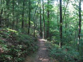
The Jacks River is known best for its spectacular huge waterfall Jacks River Falls, but much further upstream is another waterfall that is much smaller and less-known but still quite scenic: Shadow Falls. Located on the South Fork of the Jacks River, 20-foot Shadow Falls is easily accessible via the South Fork Trail. The waterfall is situated between two knobs near Jacks River Fields Campground in an area of the Jacks River watershed that otherwise has only gradual elevation loss along the course of the river. If you choose to turn the short waterfall hike into a much longer day hike or overnight, a few historic features around Flat Top Mountain await. In addition, you'll find plenty of solitude on the little-used trails on this hike, perhaps with an exception around Shadow Falls and Jacks River Fields. This hike occurred on Saturday, August 26th, 2017. My plan was to hike the South Fork Trail from the trailhead near Elliot Road, shortly joining the Benton Mackaye Trail, south to Shadow Falls and the small lower waterfall. From there, I'd hike the Benton Mackaye Trail to Flat Top Mountain, where there is a historic homestead and the foundations of an old fire tower. I would also make a side trip to the historic Dyer Cemetery along the way. I would then return along the BMT to FS Road 64 and follow FS 64 West past Jacks River Fields Campground to Buddy Cove Gap. I would conclude the hike by following the Pinhoti Trail northward back to South Fork Trail and Elliot Road.
1 Comment

The Pinhoti Trail is a long-distance trail that runs for over 300 miles across Alabama and Georgia. Portions of it are still in the development stage, particularly in West Georgia where little public land is available. The northernmost part of the PT is in the Cohutta Mountains, where the trail is remote and little-traveled due to an overall lack of significant features. The section of the Pinhoti between Mulberry Gap Road and Highway 52 is on the southern fringe of the Cohutta Mountains is a well-constructed trail that is great for a mostly relaxing walk with good exercise. Even though this segment of the trail is a bit more popular due to its proximity to two roadways, you will still find it mostly peaceful except where it approaches Highway 52. As a bonus, a very short road-walk from the end of the segment will lead you to a grassy clearing with panoramic views of the Cohutta Mountains. This hike occurred on Saturday, August 19th, 2017. My plan was to hike out and back along the Pinhoti Trail from Mulberry Gap Road to Highway 52 and to Cohutta Overlook.

Mill Shoals Creek, flowing off the eastern fringe of Talladega Mountain, is home to two of the few water features in the Cheaha Wilderness part of Talladega National Forest. Once you cruise past the two waterfalls, start on a clockwise loop that will take you through thickets of mountain laurel, through boulder fields, and pass grand rock cliffs, before reaching the grand destination - a beautiful vista on a rock outcrop which provides unobstructed views westward into the heart of Alabama. Finish the loop with some boulder field hiking and back down Mill Shoals Creek. This hike occurred on Sunday, April 24th, 2015. My plan was to hike the Nubbin Creek Trail to its terminus at the Odum Scout Trail. From here on, I'd turn right and take the Odum Scout Trail to its terminus at the Pinhoti Trail. Next, I would turn right and take the Pinhoti Trail to the Cave Creek Connector. Then, I would turn right onto Cave Creek Connector, connect to Cave Creek Trail, and turn right to follow the Cave Creek Trail to its terminus back at the Nubbin Creek Trail. I would finish the hike by returning the way I came on Nubbin Creek Trail.
 There's wilderness even in Alabama. In an area of low-elevation ridges and long valleys lies the Cheaha Widerness of the Talladega National Forest. While this is only a mini version of the mountains further north, the Talladega National Forest has numerous hiking trails, with many leading to grand views. While this wilderness is not as "wild" and rugged as the ones in Georgia and North Carolina, it still isn't an easy hike. This hike occurred on Saturday, May 17th, 2014. My plan was to drive up the Talladega Skyway to the Cheaha Wilderness Trailhead. I would hike the Cave Creek Trail to the Pinhoti Connector, follow the Pinhoti Connector to the Pinhoti Trail, and follow the Pinhoti Trail back to the parking lot. Along the way, I would stop at McDill Overlook for what was clearly the most beautiful view I have seen in Alabama, if not one of the most beautiful views I have seen in Alabama and Georgia combined. |
About MeMark Oleg Ozboyd Dear readers: I have invested a tremendous amount of time and effort in this website and the Georgia Waterfalls Database the past five years. All of the work that has gone in keeping these websites updated with my latest trip reports has almost been like a full-time job. This has not allowed me to pick up a paid job to save up money for college, and therefore, I I've had to take out loans. If you find the information on this website interesting, helpful, or time-saving, you can say "thanks" and help me out by clicking the button above and making a contribution. I will be very grateful for any amount of support you give, as all of it will apply toward my college tuition. Thank you!
Coming in 2022-2023?
Other Hiking WebsitesMiles HikedYear 1: 540.0 Miles
Year 2: 552.3 Miles Year 3: 518.4 Miles Year 4: 482.4 Miles Year 5: 259.9 Miles Archives
March 2021
Categories
All
|

 RSS Feed