
The scenic crest of the Bald Mountains that straddles the Tennessee/North Carolina border south of Greeneville, TN, features a set of spectacular vistas in the vicinity of the Appalachian Trail. The views actually begin even before you leave your car as you arrive at the beautiful Jones Meadow with a panoramic vista of Camp Creek Bald and Blackstack Cliffs. Two excellent vistas are accessed by a very short, easy walk from the parking area: Whiterock Cliff facing south into North Carolina and Blackstack Cliffs facing north into Tennessee. The Appalachian Trail then continues onto a new section, which scrambles along the knife-edge ridge-crest for over a mile across Big Firescald Knob, affording several outstanding 360-degree panoramic vistas. On your return trip, you may choose to follow the alternate bad-weather AT route, a little-used pathway on the north flanks of Big Firescald Knob that adds variety to the hike. This hike occurred on Friday, April 27th, 2018. My plan was to hike the Appalachian Trail from Jones Meadow over Big Firescald Knob, taking side trails to Whiterock Cliff and Blackstack Cliffs along the way. Rather than retracing my steps along the Big Firescald Knob ridge-crest, I would return along the AT bad-weather bypass. This hike was the third of six hikes that I did during a four-day trip to the mountains of northeast Tennessee and northwest North Carolina.
2 Comments
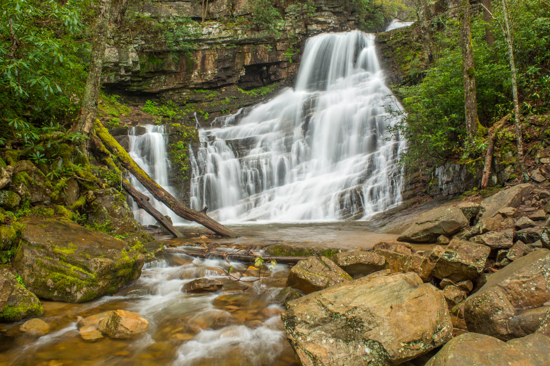
Nestled in the Bald Mountains of Northeast Tennessee, the West Fork Dry Creek valley features some of the area's most beautiful streamside scenery. A well-known hiking trail, the Margarette Falls Trail, climbs along West Fork Dry Creek close to a mile past numerous scenic cascades to the 60-foot fan-shaped drop of Margarette Falls. Above Margarette Falls is a very unique waterfall called Bailey Falls. Accessed exclusively by an off-trail creek-walk, Bailey Falls consists of separate 30-foot upper and 20-foot lower sections in a gorgeous slot canyon. For experienced waterfallers, Bailey Falls is a must-see - no other waterfall quite like it is known in Tennessee. This hike occurred on Friday, April 27th, 2018. My plan was to hike the Margarette Falls Trail out and back to Margarette Falls. I would continue following a goat path past Margarette Falls and then walk the creek to Lower & Upper Bailey Falls. This hike was the second of six hikes that I did during a four-day trip to the mountains of northeast Tennessee and northwest North Carolina.
Just off NC 281 is a lesser-known entrance to the backcountry of Panthertown Valley: the West Fork Way trailhead. The unofficial West Fork Way ascends through the West Fork French Broad River watershed for several miles, passing the extremely steep access trail to three spectacular waterfalls: Rhapsodie Falls, Dismal Falls, and Lower Dismal Falls. West Fork Way then connects to another unofficial trail on the fringes of Panthertown Valley called the Shelton-Pisgah Trail, which follows a seldom-hiked pathway along the ridge of Shelton-Pisgah Mountain to Cold Mountain. A cliff on the west side of Cold Mountain, nicknamed the High Bethel View features an outstanding vista of Panthertown Valley spread out to the west - arguably the best of the valley's five views. This hike occurred on Saturday, May 12th, 2018. My plan was to hike West Fork Way and Shelton-Pisgah Trail out and back to Cold Mountain. Along the way, I would take the side trails to Rhapsodie Falls, Dismal Falls, and Lower Dismal Falls. I would also stop by two other small falls - Aunt Sally's Falls and Lower Rhapsodie Falls.

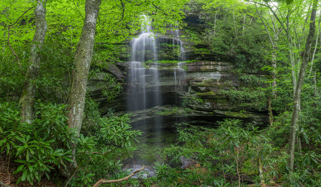
When you imagine a place with five spectacular waterfalls in one hike, the lowest region of the North Carolina mountains in the Green River valley - elevation 1000' - hardly comes to mind. And yet, the Green River Game Lands and adjacent areas surrounding Saluda are home to a variety of excellent water features. Perhaps the most breathtaking waterfall in the area is 75-foot Big Bradley Falls, a sheer twin drop on Cove Creek that forcefully crashes down through a cleft in an amphitheater of enormous cliffs. Less than a mile from Cove Creek, the off-trail hike up Little Cove Creek, and later its tributary, culminates in the remarkably unique Cavern Falls, where part of the 30-foot waterfall shoots through a perpetually wet and dark cavern. What's more, the hike to Cavern Falls passes three other waterfalls - all very beautiful and picturesque. This hike consists of two starkly different sections: one half along Little Cove Creek is a difficult bushwhack and creek-walk that is suitable for experienced off-trail adventurers only, whereas the other half along Cove Creek is a relatively easy stroll along a well-defined trail to an outstanding waterfall accessible to most hikers. This hike occurred on Saturday, May 5th, 2018. My plan was to begin the hike at the trailhead by Wilderness Cove Tubing and follow old farm roads to Little Cove Creek, where I would hike off-trail upstream along the creek and its tributary to Milton Bradley Falls, Bradley Cooper Falls, Marilou Bradley Falls, and Cavern Falls. On my return trip, I would take a side trail along Cove Creek to Big Bradley Falls.
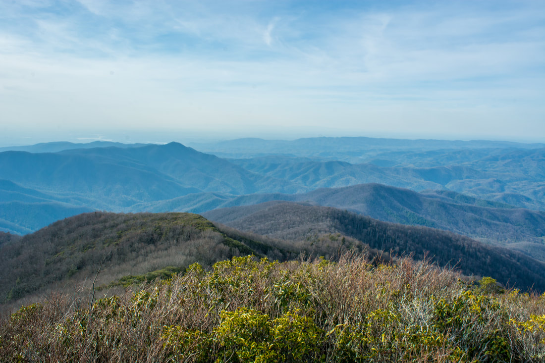
Right on the doorstep of the quaint town of Robbinsville is the Joyce Kilmer-Slickrock Wilderness, a massive wild area covering over 17,000 acres between the Cherohala Skyway and US 129. The area is known best for the Joyce Kilmer Memorial Forest - an area of virgin forest in the Little Santeetlah Creek watershed, featuring numerous old, grand trees. The wilderness area's central destination, however, is an inconspicuous rock outcropping on a lead below Haoe Bald called The Hangover. The Hangover features a breathtaking 360-degree view of the wilderness, with little in sight but endless mountain ridges and several lakes. The panoramic vista atop The Hangover encompasses Santeetlah Lake, Calderwood Lake, and the Little Tennessee River. This hike loops several trails from the Joyce Kilmer Recreation Area to visit The Hangover via the Memorial Forest. This hike occurred on Saturday, April 21st, 2018. My plan was to hike a clockwise loop with the Joyce Kilmer Memorial Forest Poplar Cove Trail, Naked Ground Trail, Haoe Lead Trail, and Jenkins Meadow Trail. I would of course take a side trip along the Hangover Lead Trail to The Hangover.
|
About MeMark Oleg Ozboyd Dear readers: I have invested a tremendous amount of time and effort in this website and the Georgia Waterfalls Database the past five years. All of the work that has gone in keeping these websites updated with my latest trip reports has almost been like a full-time job. This has not allowed me to pick up a paid job to save up money for college, and therefore, I I've had to take out loans. If you find the information on this website interesting, helpful, or time-saving, you can say "thanks" and help me out by clicking the button above and making a contribution. I will be very grateful for any amount of support you give, as all of it will apply toward my college tuition. Thank you!

Coming in 2022-2023?
Other Hiking WebsitesMiles HikedYear 1: 540.0 Miles
Year 2: 552.3 Miles Year 3: 518.4 Miles Year 4: 482.4 Miles Year 5: 259.9 Miles Archives
March 2021
Categories
All
|
 RSS Feed