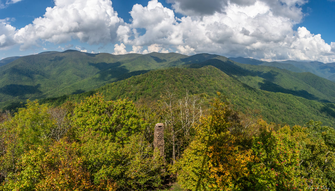
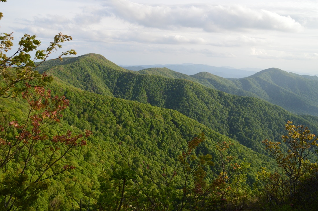
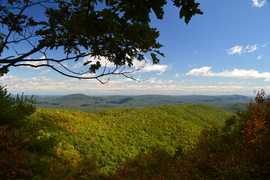
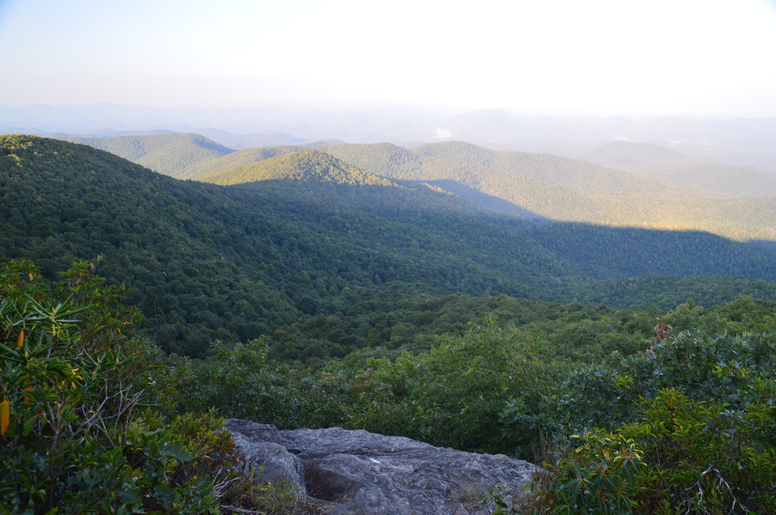
Twentymile is the southwesternmost major access point to Great Smoky Mountains National Park, and also one of the quietest. With nothing but a sleepy ranger station, small parking area, and trailhead, plus no significant destinations in close proximity, the Twentymile area remains little-visited compared to areas of the park like Cades Cove and Roaring Fork. Yet those who are willing to hike longer will find the Twentymile area quite interesting. The lengthy loop described here first follows the scenic cascades of Twentymile Creek before climbing to the Appalachian Trail and reaching the historic Shuckstack fire tower with its birds-eye view of Fontana Lake. The hike then heads deeper into the Smokies backcountry, traversing the Gregory Bald Trail - the eastern section of which near Doe Knob is one of the least-hiked trails in the park - before reaching the open grassy summit of Gregory Bald, featuring stunning 360-degree views. Even though both Shuckstack Tower and Gregory Bald can be reached via separate shorter hikes, it's hard to beat combining these two spectacular destinations into one large loop. This hike occurred on Saturday, October 6th, 2018. My plan was to initially hike the Twentymile Trail to the Appalachian Trail. After a side trip to Shuckstack, I would follow the AT north to Doe Knob. There, I'd pick up the Gregory Bald Trail and follow it all the way to Gregory Bald. On the other side of Gregory Bald, I would take the Wolf Ridge Trail and descend back to Twentymile. Although I completed this hike as a long day hike, you may find it more enjoyable as a two- or even three-day backpacking trip.
0 Comments

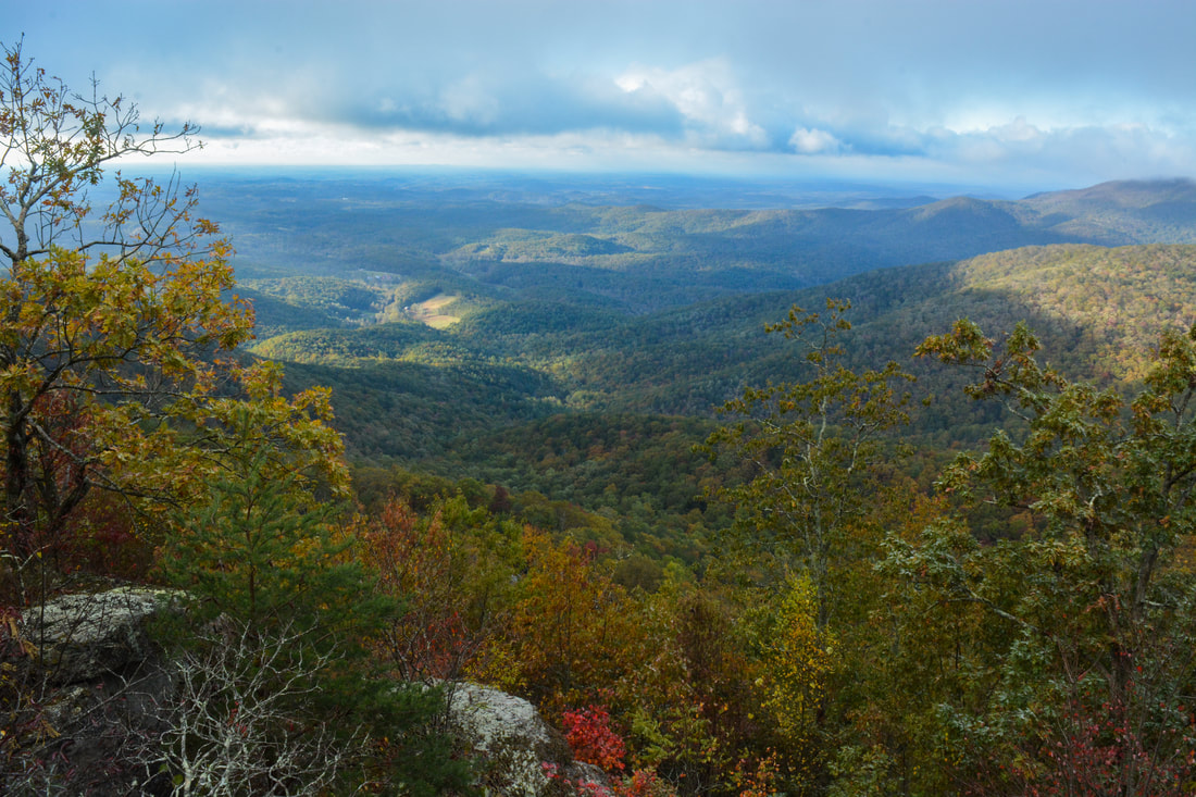
The scenic crest of the Bald Mountains that straddles the Tennessee/North Carolina border south of Greeneville, TN, features a set of spectacular vistas in the vicinity of the Appalachian Trail. The views actually begin even before you leave your car as you arrive at the beautiful Jones Meadow with a panoramic vista of Camp Creek Bald and Blackstack Cliffs. Two excellent vistas are accessed by a very short, easy walk from the parking area: Whiterock Cliff facing south into North Carolina and Blackstack Cliffs facing north into Tennessee. The Appalachian Trail then continues onto a new section, which scrambles along the knife-edge ridge-crest for over a mile across Big Firescald Knob, affording several outstanding 360-degree panoramic vistas. On your return trip, you may choose to follow the alternate bad-weather AT route, a little-used pathway on the north flanks of Big Firescald Knob that adds variety to the hike. This hike occurred on Friday, April 27th, 2018. My plan was to hike the Appalachian Trail from Jones Meadow over Big Firescald Knob, taking side trails to Whiterock Cliff and Blackstack Cliffs along the way. Rather than retracing my steps along the Big Firescald Knob ridge-crest, I would return along the AT bad-weather bypass. This hike was the third of six hikes that I did during a four-day trip to the mountains of northeast Tennessee and northwest North Carolina.
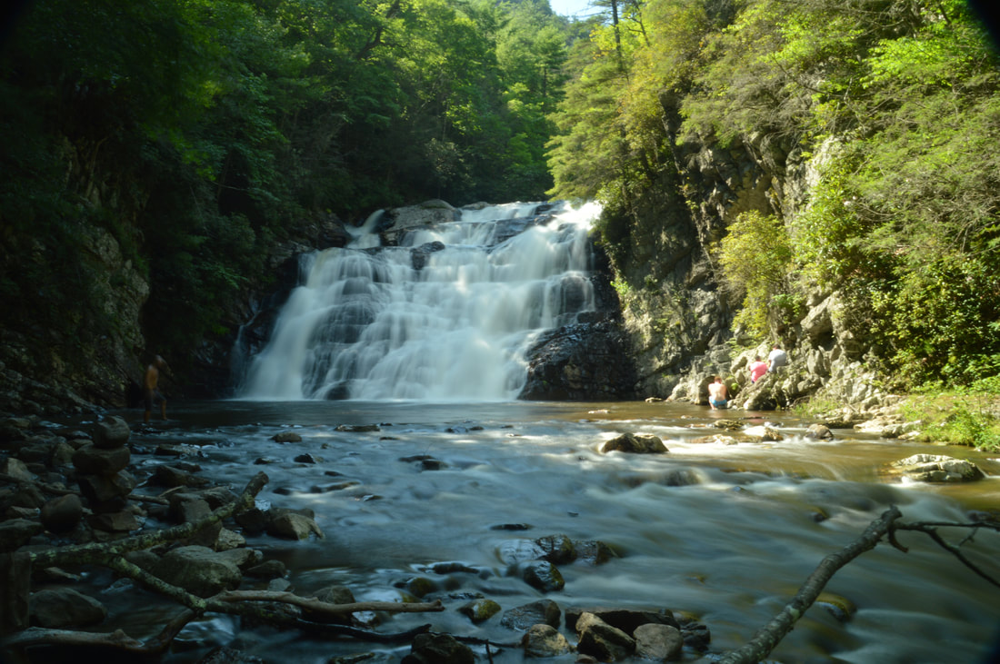
Preachers Rock is a well-known destination along the Appalachian Trail on Big Cedar Mountain that features a great view of the Blood Mountain Wilderness. A couple of other trails in the area can be utilized to create a loop hike from either Chestatee Overlook (on Highway 60) or Dockery Lake, visiting one other vista as well as up to three waterfalls. The unofficial Steeltrap Knob Trail provides a useful connection between Chestatee Overlook and Woody Gap, at the same visiting a spectacular view of the Georgia Piedmont from little-known cliffs on the side of Steeltrap Knob. Meanwhile, the Dockery Lake Trail travels through the Pigeon Roost Creek Valley between Dockery Lake and the Appalachian Trail. While no waterfalls are right on the trail, visiting Martha's Falls, Twin Falls, and Dockery Lake Falls will require only short off-trail diversions. This hike occurred on Sunday, October 29th, 2017. My plan was to hike a loop from Chestatee Overlook, starting with the Steeltrap Knob Trail and stopping by the Steeltrap Knob Vista along the way. I would then take the Appalachian Trail over Big Cedar Mountain and to the Dockery Lake Trail, stopping by several views from Big Cedar Mountain along the way, including Preachers Rock. Next, I would take the Dockery Lake Trail to Dockery Lake, visiting Twin Falls, Martha's Falls, and Dockery Lake Falls along the way. I would conclude the hike with a walk up Dockery Lake Road back to Highway 60 and Chestatee Overlook.
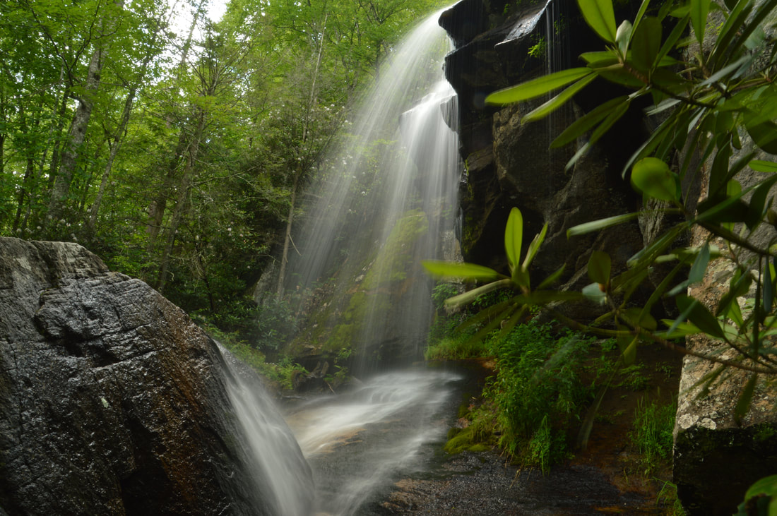
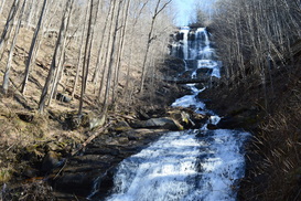
The 55-foot Laurel Falls is one of Northeast Tennessee's most breathtaking waterfalls. Located just outside of the community of Hampton and off the Appalachian Trail in Pond Mountain Wilderness, access to Laurel Falls is fairly easy, making it a destination that can often be crowded, but the falls and the whole hike is still worthwhile - for there is a lot more to see along this stretch of the AT. Above Laurel Falls, an unofficial side trail makes a steep scramble to the pointy summit of Potato Top, where there are several excellent views of the Laurel Fork Gorge and surrounding wilderness. In addition, the Appalachian Trail between US 321 and Dennis Cove Road passes a lot of pretty creekside scenery and several spectacular cliffs that rise along Laurel Fork Creek. This hike occurred on Sunday, July 9th, 2017. My plan was to hike out and back along the Hampton Blueline Trail and then Appalachian Trail from the trailhead off US 321 near Hampton to the Dennis Cove Trailhead. Along the way, I would take the side trails to Potato Top and Laurel Falls, and on my way back, I would take the high-water bypass route past Laurel Fork Shelter above Laurel Falls for a bit of variation. This hike was the eighth of ten hikes that I did during a seven-day trip to the mountains of northwest North Carolina.
If you're looking for the perfect combination of beauty and ease of access to a waterfall in North Carolina, Elk River Falls has to be at the top of your list. A well-used relaxing trail leads along the banks of the mighty Elk River to the base of Elk River Falls, a tight sheer 50-foot drop into a huge plunge pool that is known for its swimming opportunities. Most folks who hike to Elk River Falls don't know that another excellent waterfall can be reached fairly easily from the same trailhead. 100-foot Jones Falls is on a small tributary of the Elk River and during the wetter months is a sight no less impressive than Elk River Falls. A signed spur trail from the Appalachian Trail facilitates access to this gorgeous spot. Hikers will be able to see both waterfalls with a hike of fewer than four miles. This hike occurred on Wednesday, July 5th, 2017. My plan was to hike out and back to Elk River Falls and then to follow a forest road and unofficial connector path to the Appalachian Trail, which I would use to reach Jones Falls. I would return the same way. This hike was the first of ten hikes that I did during a seven-day trip to the mountains of northwest North Carolina.
The Upper Tallulah River splits the Southern Nantahala Wilderness's lower region into two nearly separate parts. To the east of the Tallulah River, some of the wilderness's most famous landmarks are situated, such as Standing Indian Mountain, High Falls, and Denton Creek Falls, each of which is reached by well-used trails. The rugged terrain to the west of the Tallulah River tells a whole different story, however. Few official trails traverse this remote area, but a pair of unofficial footpaths provide access from the bottom of the valley all the way to the ridgetops. A beautiful waterfall called Oversoul Falls is found along the unmaintained Holden Cove Trail, and a difficult trek away from the Bly Gap Trail will lead an experienced hiker to Fall Branch Falls, a long series of steep cascades and slides. Even the Appalachian Trail in this area is used lightly compared to many other sections of the AT, and you're not likely to meet any people along the way to the breathtaking Ravenrock Cliff Overlook. This hike was occurred on Saturday, May 20th, 2017. My plan was to begin the day with a surprisingly difficult bushwhack from the Bly Gap Trailhead to Fall Branch Falls. Then, I would move on the main hike of the day, placing a second car at the Holden Cove Trailhead and hiking the Holden Cove Trail past Oversoul Falls to the Appalachian Trail and to Ravenrock Cliff Overlook. I would finish the hike by following the AT to Bly Gap and then hiking the Bly Gap Trail back to the first car. Folks without the option of taking two cars for the hike would have to make a final 2-mile roadwalk to complete the loop.
One of Georgia's most scenic hikes is along the Appalachian Trail from Neels Gap to Hogpen Gap. Along this section of the AT, the famed long-distance footpath passes over several summits that offer outstanding long-range vistas. Along the way, you will first walk along the only piece of the AT that passes under a building, at the Walasi-Yi Interpretive Center. Afterwards, you will hike across Levelland Mountain, Wolf Laurel Top, Cowrock Mountain, and Wildcat Mountain, each of which has its own breathtaking view (or several). This hike occurred on Saturday, February 11th, 2017. My plan was to hike the Byron Herbert Reece Trail from US 129 to the Appalachian Trail. There, I would pick up the Appalachian Trail and follow it through Neels Gap and to Hogpen Gap. Along the way, I would make side trips to views on Levelland Mountain and Cowrock Mountain. I arranged to have two cars for this point-to-point hike: one car was placed at the Byron Herbert Reece Trailhead and another car was placed at the Hogpen Gap Trailhead.
Folks who live in the Atlanta metro area are very familiar with the Chattahoochee River: one of Georgia's largest rivers and a source of drinking water for many. But where does the river begin? In the North Georgia Mountains near Helen and Hiawassee, where a tiny spring gives birth to a rivulet that is the same Chattahoochee River as the one that feeds Lake Lanier and Walter F. George Lake. The Jacks Knob Trail in Chattahoochee National Forest's Mark Trail Wilderness is the shortest route to the source of the Chattahoochee River. The Chattahoochee Spring isn't the only point of interest in the area, however; two nearby creeks drop off the north side of the Tennessee Valley Divide and form large waterfalls on their way into the Hiwassee River valley. This hike occurred on Saturday, January 7th, 2017. My plan was to hike the Jacks Knob Trail from Jacks Gap to Chattahoochee Gap. After seeing the Chattahoochee Spring, I would hike the Appalachian Trail from Chattahoochee Gap to Red Clay Gap. This is where I would pick up an unofficial side trail north into the Joel Creek valley, visiting Joel Creek Falls and Gurley Creek Falls. I would return to Jacks Gap by walking along Route 180.
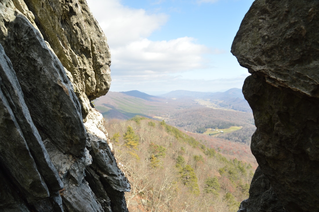
Virginia's "Triple Crown" hike involves a strenuous overnight backpack to three of the area's most famed vistas: McAfee Knob, Dragons Tooth, and Tinker Cliffs. All of these vistas are known for their sweeping long-range panoramas. While getting to all three of these overlooks in one hike requires serious stamina and overnight gear, hiking to any one of the three involves just a simple day hike. Out of the three, Dragons Tooth - as well as the hike to it - might be the most unusual. Dragons Tooth is a unique rock formation that towers like a spire at the southwest end of Cove Mountain. Those who are brave and skilled enough to climb to the top will be awarded with a stunning panorama that encompasses much of Catawba Valley. The hike to Dragons Tooth is no picnic either; this short stretch of the AT - dubbed as the most rugged stretch of the long-distance footpath south of Maine - involves a tricky and time-consuming rock scramble. This hike occurred on Saturday, November 26th, 2016. My plan was to hike the Dragons Tooth Trail to Lost Spectacles Gap, from where I would hike to Dragons Tooth out and back along the Appalachian Trail. After that, I would loop my return route by following the AT northeast to the Boy Scout Trail, concluding the hike along the Boy Scout Trail. This hike was the fifth of seven hikes that I did during a four-day Thanksgiving trip to the mountains of western Virginia.
Blood Mountain Wilderness: Slaughter Creek Loop and Blood Mountain via Freeman Loop, Suches, Georgia12/20/2016 
Blood Mountain is one of the best-known mountains in Georgia for a variety of reasons, including the ease of access to the great views from the several rock slabs near the summit of the peak. The easiest approach to the top is from Highway 129, but several other trails, in addition to the Appalachian Trail itself, are found in the vicinity of Blood Mountain. Two such trails - the Jarrard Gap Trail and Slaughter Creek Trail - leave the Lake Winfield Scott Recreation Area and access the AT west of Blood Mountain. Another trail, the Freeman Trail, winds around hollows on the south side of Blood Mountain, providing a tricky passage through numerous boulder fields. You'll walk all of these trails as you hike to Blood Mountain using the "back way". This hike occurred on Saturday, October 15th, 2016. My plan was to hike the Jarrard Gap Trail from Lake Winfield Scott to the Appalachian Trail, from where I would follow the AT to the Freeman Trail, taking the spur trail to Woods Hole Shelter. Then, I would take the Freeman Trail around the south side of Blood Mountain, before meeting the Appalachian Trail again and following it to the top of Blood Mountain. I would finish the hike by descending on the Appalachian Trail to the Slaughter Creek Trail and taking the Slaughter Creek Trail back to Lake Winfield Scott.
The Appalachian Trail has both grand vistas as well as much smaller ones that are equally breathtaking. The view from Wolfstake Knob falls into the latter category. Located on the Tennessee Valley Divide, Wolfstake Knob provides a memorable view to the east with Lake Burton and the mountains of Rabun County in the picture. On this hike, you will follow the Appalachian Trail to the great view from Wolfstake Knob, and then, you will continue following the footpath which becomes much less used and provides plenty of solitude around Kelly Knob and Addis Gap. This hike occurred on Saturday, October 8th, 2016. My plan was to hike the Appalachian Trail out and back from Dicks Creek Gap to Addis Gap. I would take the spur trail to Wolfstake Knob and its views, as well as the spur trail to Deep Gap Shelter, along the way.
Rocky Mountain and Tray Mountain are two rocky peaks with impessive views on the Appalachian Trail in north Georgia near Helen. Tray Mountain is also the seventh-highest mountain in Georgia. Other than the Appalachian Trail, a couple of additional trails are used to access the area. The Rocky Mountain Trail bends around the northern side of Rocky Mountain, which serves as a bypass for the rocky summit area of Rocky Mountain as well creates a popular loop hike. The Andrews Cove Trail begins nearly two thousand feet below the summit of Rocky Mountain and ascends through a lush mountain cove past several small tumbling streams before joining the Appalachian Trail. On this hike, you will first ascend along the Andrews Cove Trail to the Appalachian Trail, before hiking the Rocky Mountain Loop past the great views from the namesake peak, and finishing with an outing along the AT to the summit of Tray Mountain, where more views await. This hike occurred on Saturday, September 10th, 2016. My plan was to hike the Andrews Cove Trail to the Appalachian Trail at Indian Grave Gap. From there, I would hike the Rocky Mountain Loop clockwise, and then, I would hike the Appalachian Trail out and back to the summit of Tray Mountain as well as locate a little-known vista on the mountain's east side. I would finish by retracing my steps along the Andrews Cove Trail.
729-foot Amicalola Falls is famous for being the highest waterfall in Georgia. Nestled in Amicalola Falls State Park, the falls attracts a crowd of tourists all throughout the year. A network of hiking trails and pathways is positioned around the falls and both to the west and east of it. For those seeking a more intimidating hike that relatively has some solitude, the park has two trails that head out into nearby Chattahoochee National Forest. The Hike Inn Trail leads to a lodge that is accessible only by foot five miles from the park, while the AT Approach Trail acts as the access trail to Springer Mountain - the southern terminus of the Appalachian Trail. You'll be treated to continuous winter views and several year-round viewpoints on both trails. This hike occurred on Saturday, March 4, 2016. My plan was to take the AT Approach Trail from the Visitor Center past Amicalola Falls and to the Hike Inn parking area and trailhead. From there, I would take the Hike Inn Trail to the Len Foote Hike Inn and then to the AT Approach Trail near Amicalola Mountain. Then, I would take the AT Approach Trail to Springer Mountain. I would return to the Hike Inn Trailhead using solely the AT Approach Trail. From the Hike In Trailhead, I would take East Ridge Trail to the Visitor Center.
 The Standing Indian Backcountry Area and the Southern Nantahala Wilderness comprise one unbroken tract of mountains and deep river valleys near the town of Franklin. The headquarters of Nantahala River, one of North Carolina's best-known rivers, are located here. Dozens of miles of hiking trails weave through the area. Two mountains are the key destinations in the region: Albert Mountain and Standing Indian Mountain. On this hike, you'll have the opportunity to use seldom-traveled trails in a loop or shuttle hike that visits the summit of Albert Mountain. This hike occurred on December 5th, 2015. My plan was to hike the Bearpen Gap Trail from the lower end near the Nantahala River to the upper end at the Appalachian Trail. From there, I would follow the Appalachian Trail up and over Albert Mountain to the Long Branch Trail. Using the Long Branch Trail, I would return to FS 67 and the Nantahala River area. I would finish by walking FS 67 back to the Bearpen Trail.
Springer Mountain is not any regular mountain. It's a special place. Springer Mountain is the southern terminus of the famous Appalachian Trail. Every year, thousands of hikers start a journey here that will last many months. Other hikers finish their long thru-hikes at this point, and when they reach the summit of the mountain, after hiking in from Three Forks, they've achieved an accomplishment. On this day hike, you'll feel almost like those southbound thru-hikers as you make the southernmost climb on the Appalachian to reach the first (or last) white blaze on the Appalachian Trail. You'll return using a lesser-traveled route using the alternative Benton Mackaye Trail. This hike occurred on Saturday, August 1st, 2015. My plan was to follow the Appalachian Trail from Three Forks to the summit of Springer Mountain. I would return back to Three Forks via the Benton Mackaye Trail.
|
About MeMark Oleg Ozboyd Dear readers: I have invested a tremendous amount of time and effort in this website and the Georgia Waterfalls Database the past five years. All of the work that has gone in keeping these websites updated with my latest trip reports has almost been like a full-time job. This has not allowed me to pick up a paid job to save up money for college, and therefore, I I've had to take out loans. If you find the information on this website interesting, helpful, or time-saving, you can say "thanks" and help me out by clicking the button above and making a contribution. I will be very grateful for any amount of support you give, as all of it will apply toward my college tuition. Thank you!

Coming in 2022-2023?
Other Hiking WebsitesMiles HikedYear 1: 540.0 Miles
Year 2: 552.3 Miles Year 3: 518.4 Miles Year 4: 482.4 Miles Year 5: 259.9 Miles Archives
March 2021
Categories
All
|
 RSS Feed