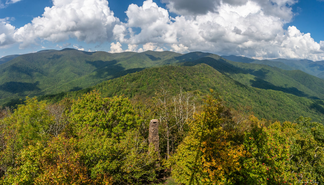
Twentymile is the southwesternmost major access point to Great Smoky Mountains National Park, and also one of the quietest. With nothing but a sleepy ranger station, small parking area, and trailhead, plus no significant destinations in close proximity, the Twentymile area remains little-visited compared to areas of the park like Cades Cove and Roaring Fork. Yet those who are willing to hike longer will find the Twentymile area quite interesting. The lengthy loop described here first follows the scenic cascades of Twentymile Creek before climbing to the Appalachian Trail and reaching the historic Shuckstack fire tower with its birds-eye view of Fontana Lake. The hike then heads deeper into the Smokies backcountry, traversing the Gregory Bald Trail - the eastern section of which near Doe Knob is one of the least-hiked trails in the park - before reaching the open grassy summit of Gregory Bald, featuring stunning 360-degree views. Even though both Shuckstack Tower and Gregory Bald can be reached via separate shorter hikes, it's hard to beat combining these two spectacular destinations into one large loop. This hike occurred on Saturday, October 6th, 2018. My plan was to initially hike the Twentymile Trail to the Appalachian Trail. After a side trip to Shuckstack, I would follow the AT north to Doe Knob. There, I'd pick up the Gregory Bald Trail and follow it all the way to Gregory Bald. On the other side of Gregory Bald, I would take the Wolf Ridge Trail and descend back to Twentymile. Although I completed this hike as a long day hike, you may find it more enjoyable as a two- or even three-day backpacking trip.
0 Comments
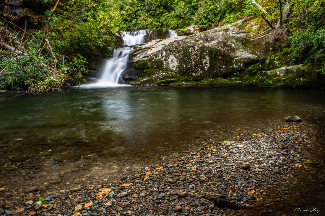
Imagine a large mountain waterway winding its way through a wilderness for nearly a dozen miles with zero road access. Picture a rugged, little-traveled pathway following this waterway, crisscrossing the creek many times through deep, slick fords, circumnavigating countless blowdowns and rock scrambles. There, you've discovered the Slickrock Creek Trail! This is the best creek trail I've ever walked in the Southern Appalachian Mountains, and I'm not even exaggerating. Nowhere else have I found a combination of such remote beauty and rugged wilderness trail, which never follows any of the logging roads customary to most North Carolina waterways. As if you needed more incentive to tackle this hike, the Slickrock Creek Trail features two secluded waterfalls - Wildcat Falls and Lower Falls - with swimming holes that couldn't be any more refreshing after a long summer day in the backcountry. This hike occurred on Saturday, September 15th, 2018. My plan was to day hike a lengthy loop through the heart of the Joyce Kilmer-Slickrock Creek Wilderness backcountry. I would start off along the Slickrock Creek Trail at Cheoah Dam along US 129, but before long, I would take the Ike Branch Trail. At Yellowhammer Gap, I would pick up the Yellowhammer Gap Trail, followed by the Nichols Cove Trail and Windy Gap Trail. The Windy Gap Trail would finally bring me to Slickrock Creek, from where I'd spend the rest of the day tracing the Slickrock Creek Trail back to US 129.
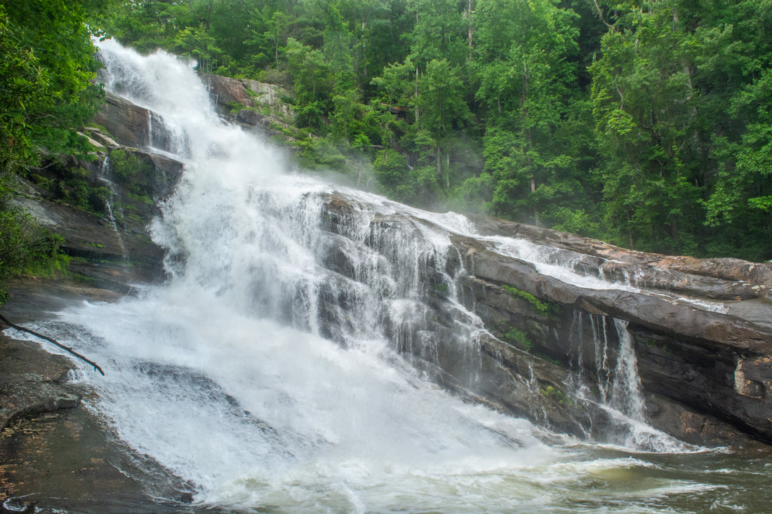
There's the touristy side of the Horsepasture River. There's the monster Rainbow Falls and its sidekicks, Stairway Falls, Turtleback Falls, and Drift Falls, all some of Gorges State Park's most popular and highly-regarded destinations. And then there's Windy Falls... the Horsepasture's truly wild side, tackled only by the most hardcore waterfallers and rock climbers. The Horsepasture's other waterfalls pale in comparison in the mighty shadow of Windy Falls, which crashes over 200 vertical feet through a conglomerate of boulders the sizes of two-story houses and slanted cliffs the sizes of small football fields. Those who reach this monster waterfall's base will be rewarded with a first-rate view of raw, breathtaking power, dwarfed by the even more majestic rocky surroundings. Yet reaching the base is an adventure not to be taken lightly, involving two rock scrambles with ropes and a squeeze through a keyhole perfect for getting stuck if you're larger than the average person. Gorges State Park neither sanctions nor recommends the trip to Windy Falls, and neither do I. Only people with substantial experience in cross-country rock scrambling with ropes must attempt to reach the base; those who don't could get injured or even fall to their deaths. Proceed at your own risk. This hike occurred on Saturday, September 8th, 2018. My plan was to hike out and back to the base of Windy Falls using a steep, unofficial trail from Chestnut Mountain Road concluding in a series of technical and potentially dangerous rock scrambles.

The Shining Rock Wilderness is Southwest North Carolina's high country - an area crowned by numerous 6000-foot peaks with stunning mountain views. Deep in the Little East Fork Pigeon River valley is the Daniel Boone Scout Camp, a convenient entry point to the Shining Rock Wilderness near its northern end. Two trails, Little East Fork Trail and Art Loeb Trail, leave the camp and make for a long, scenic loop visiting a number of the wilderness's highlights in its north sector. Climbing steeply out of the valley, the Art Loeb Trail's first stop is Deep Gap, where a 1.5-mile side trail leads to several panoramic overlooks atop Cold Mountain. The Art Loeb then embarks on an exciting journey through The Narrows, where a series of ups and downs along a knife-edge ridge take you past two great views and numerous rock outcrops. After a gradual climb up Stairs Mountain through gorgeous mossy spruce-fir forest, the Art Loeb approaches the wilderness's center point: Shining Rock. Featuring its own panoramic views, Shining Rock is a huge outcropping of brilliant white quartz amidst a sea of evergreen. Backpackers will find Shining Rock to be a great sunset-viewing location. Your exit route from the wilderness is the Little East Fork Trail, which descends an old roadbed along the countless pleasant cascades of Little East Fork's scenic run. This hike occurred on Saturday, June 9th, 2018. My plan was to hike the Scout Camp Loop clockwise, first hiking the Art Loeb Trail and then Little East Fork Trail. Along the way, I took side trips to Cold Mountain and Shining Rock.
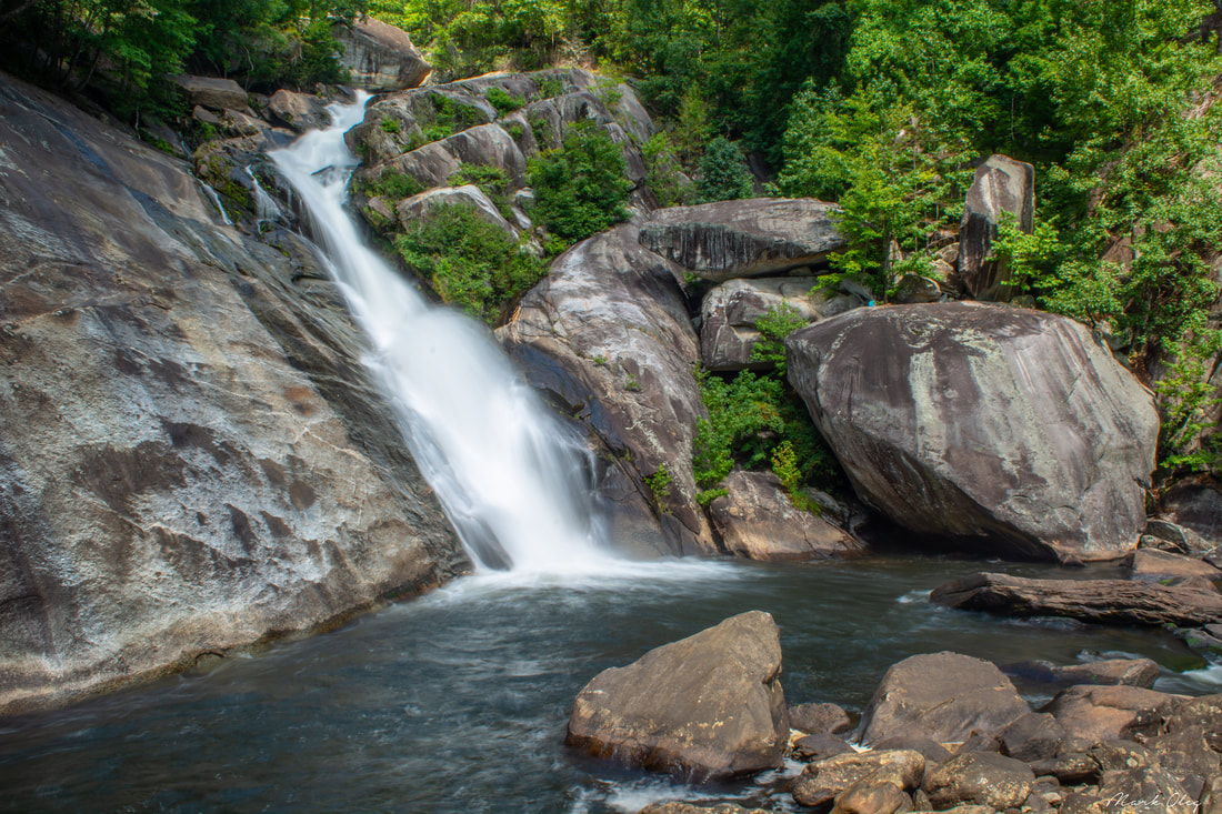
The Thompson River is one of several great rivers in the Jocassee Gorges region on the south side of Lake Toxaway. Although the Thompson River isn't as well-known as the nearby Whitewater River (due to Whitewater Falls) or Horsepasture River (due to Rainbow Falls), the Thompson features a collection of gorgeous waterfalls, including a 200-foot monster called Big Falls. Big Falls on Thompson River is an awesome, massive waterfall that crashes down through an enormous open area full of cliffs and borders. This spectacular waterfall should be on every experienced waterfaller's must-see list. Much of the hike to Big Falls follow an unofficial moderate trail along an old logging road that meanders near the Thompson River. However, the final section of the Big Falls hike is an extreme descent into the gorge, including several short rock scrambles. Along the Big Falls hike, you'll pass side trails to three other beautiful waterfalls that are all unique in their own ways and are worth seeing. This hike occurred on Saturday, May 26th, 2018. My plan was to hike out and back to Big Falls from Brewer Road. On my way in, I would make a side trip to Simon Falls. On my return trip, I would make side trips to Rich Falls and High Falls. Unfortunately, a series of heavy thunderstorms messed up my plans slightly, but it was still a great day.

The scenic crest of the Bald Mountains that straddles the Tennessee/North Carolina border south of Greeneville, TN, features a set of spectacular vistas in the vicinity of the Appalachian Trail. The views actually begin even before you leave your car as you arrive at the beautiful Jones Meadow with a panoramic vista of Camp Creek Bald and Blackstack Cliffs. Two excellent vistas are accessed by a very short, easy walk from the parking area: Whiterock Cliff facing south into North Carolina and Blackstack Cliffs facing north into Tennessee. The Appalachian Trail then continues onto a new section, which scrambles along the knife-edge ridge-crest for over a mile across Big Firescald Knob, affording several outstanding 360-degree panoramic vistas. On your return trip, you may choose to follow the alternate bad-weather AT route, a little-used pathway on the north flanks of Big Firescald Knob that adds variety to the hike. This hike occurred on Friday, April 27th, 2018. My plan was to hike the Appalachian Trail from Jones Meadow over Big Firescald Knob, taking side trails to Whiterock Cliff and Blackstack Cliffs along the way. Rather than retracing my steps along the Big Firescald Knob ridge-crest, I would return along the AT bad-weather bypass. This hike was the third of six hikes that I did during a four-day trip to the mountains of northeast Tennessee and northwest North Carolina.
Just off NC 281 is a lesser-known entrance to the backcountry of Panthertown Valley: the West Fork Way trailhead. The unofficial West Fork Way ascends through the West Fork French Broad River watershed for several miles, passing the extremely steep access trail to three spectacular waterfalls: Rhapsodie Falls, Dismal Falls, and Lower Dismal Falls. West Fork Way then connects to another unofficial trail on the fringes of Panthertown Valley called the Shelton-Pisgah Trail, which follows a seldom-hiked pathway along the ridge of Shelton-Pisgah Mountain to Cold Mountain. A cliff on the west side of Cold Mountain, nicknamed the High Bethel View features an outstanding vista of Panthertown Valley spread out to the west - arguably the best of the valley's five views. This hike occurred on Saturday, May 12th, 2018. My plan was to hike West Fork Way and Shelton-Pisgah Trail out and back to Cold Mountain. Along the way, I would take the side trails to Rhapsodie Falls, Dismal Falls, and Lower Dismal Falls. I would also stop by two other small falls - Aunt Sally's Falls and Lower Rhapsodie Falls.

When you imagine a place with five spectacular waterfalls in one hike, the lowest region of the North Carolina mountains in the Green River valley - elevation 1000' - hardly comes to mind. And yet, the Green River Game Lands and adjacent areas surrounding Saluda are home to a variety of excellent water features. Perhaps the most breathtaking waterfall in the area is 75-foot Big Bradley Falls, a sheer twin drop on Cove Creek that forcefully crashes down through a cleft in an amphitheater of enormous cliffs. Less than a mile from Cove Creek, the off-trail hike up Little Cove Creek, and later its tributary, culminates in the remarkably unique Cavern Falls, where part of the 30-foot waterfall shoots through a perpetually wet and dark cavern. What's more, the hike to Cavern Falls passes three other waterfalls - all very beautiful and picturesque. This hike consists of two starkly different sections: one half along Little Cove Creek is a difficult bushwhack and creek-walk that is suitable for experienced off-trail adventurers only, whereas the other half along Cove Creek is a relatively easy stroll along a well-defined trail to an outstanding waterfall accessible to most hikers. This hike occurred on Saturday, May 5th, 2018. My plan was to begin the hike at the trailhead by Wilderness Cove Tubing and follow old farm roads to Little Cove Creek, where I would hike off-trail upstream along the creek and its tributary to Milton Bradley Falls, Bradley Cooper Falls, Marilou Bradley Falls, and Cavern Falls. On my return trip, I would take a side trail along Cove Creek to Big Bradley Falls.
Right on the doorstep of the quaint town of Robbinsville is the Joyce Kilmer-Slickrock Wilderness, a massive wild area covering over 17,000 acres between the Cherohala Skyway and US 129. The area is known best for the Joyce Kilmer Memorial Forest - an area of virgin forest in the Little Santeetlah Creek watershed, featuring numerous old, grand trees. The wilderness area's central destination, however, is an inconspicuous rock outcropping on a lead below Haoe Bald called The Hangover. The Hangover features a breathtaking 360-degree view of the wilderness, with little in sight but endless mountain ridges and several lakes. The panoramic vista atop The Hangover encompasses Santeetlah Lake, Calderwood Lake, and the Little Tennessee River. This hike loops several trails from the Joyce Kilmer Recreation Area to visit The Hangover via the Memorial Forest. This hike occurred on Saturday, April 21st, 2018. My plan was to hike a clockwise loop with the Joyce Kilmer Memorial Forest Poplar Cove Trail, Naked Ground Trail, Haoe Lead Trail, and Jenkins Meadow Trail. I would of course take a side trip along the Hangover Lead Trail to The Hangover.
The trails at the west end of Panthertown Valley feature several popular waterfalls: Wilderness Falls, Frolictown Falls, and Granny Burrell Falls, as well as a spectacular well-known cliff line on the south side of Big Green Mountain called the Great Wall. This hike visits all of these destinations, in addition to lesser-known views atop Big Green Mountain itself. This hike also follows the Deep Gap Trail out of Panthertown Valley onto the seldom-hiked Laurel Knob Trail, a climbers' access trail that leads to the base of the 1200-foot cliffs of Laurel Knob. Laurel Knob boasts of the tallest uninterrupted cliff face in the entire Eastern United States! This hike occurred on Saturday, March 31st, 2018. My plan was to start out at the Salt Rock Gap Trailhead, where I'd take the Wilderness Falls Trail past Wilderness Falls to the Deep Gap Trail at Frolictown Falls. I'd then hike the Deep Gap Trail and Laurel Knob Trail out and back to the base of the Laurel Knob cliffs. Next, I'd return to Frolictown Falls, and I'd take the Great Wall Trail toward the top of Big Green Mountain, making a side trip to Granny Burrell Falls along the way. I would then follow the Big Green Trail past several views and continue down an unofficial connector to Macs Gap Trail. Finally, I'd follow the Macs Gap Trail and Panthertown Valley Trail back out to Salt Rock Gap.
Below the Lake Glenville Dam, the West Fork of the Tuckasegee River comes over a mighty 100-foot cataract known as High Falls (locally as Cullowhee Falls). Most of the year, the dam severely restricts the watershed flow, reducing the water level at High Falls to only a few slim ribbons. But there's a few times in the year when High Falls is transformed into a monster. Several days a year, water is released from Lake Glenville down the West Fork Tuckasegee River for kayakers, and the water subsequently crashes over High Falls. Watching High Falls transform in mere seconds from a low-flow waterfall into one that's totally flooded out is an astounding experience! Two trails lead to the base of High Falls: a steep, official trail through Duke Energy land from The Pines Recreation Area by the shores of Lake Glenville to the south, and an easy, unofficial pathway through private land from Shoal Creek Mountain Road to the north. This trail report describes the Shoal Creek Mountain Road access, which the property owners have graciously opened to the public. Even though it's over twice longer, the north access is highly recommended due to the relaxing nature of the pathway, the better vantage points of High Falls, and a bonus waterfall called Rough Run Falls. This hike occurred on Saturday, April 7th, 2018. My plan was to hike out and back to High Falls from Shoal Creek Mountain Road, stopping by Rough Run Falls along the way.
Southeast of the small college town of Cullowhee is the Caney Fork watershed, an area known little to most folks outside of locals. Although there aren't any notable waterfalls on the Caney Fork itself, many of its tributaries feature beautiful falls. Rough Butt Creek Falls is one of the nicer Caney Fork area falls, and it also happens to be fairly easy to access. Rough Butt Creek Falls is a gorgeous, picturesque cascade about 30 feet high that drops into a perfect, tranquil pool. Below the falls, you'll be treated to views of a particularly scenic section of the creek with numerous swift cascades and mossy rocks. This hike occurred on Saturday, March 24th, 2018. My plan was to hike out and back to Rough Butt Creek Falls along the shortest way.
Above Ellicott Rock, the famous Wild & Scenic Chattooga River is wilder, steeper, and less-frequented. A separate stand-alone section of the Chattooga River Trail, not connected to the trail's main course from Ellicott Rock southward, travels several miles along the river between Whiteside Cove Road and Bullpen Bridge. This section of the Chattooga River Trail may actually be its most scenic, with numerous views of whitewater rapids interrupted by tranquil pools on the river. In addition, the trail passes near three unique sets of narrows on the river, one of which meets the definition of a true slot canyon. The trailside upper narrows are right by the confluence of Norton Mill Creek, featuring its own picturesque cascades. In addition, a series of spur paths and a short bushwhack leads more adventurous hikers to a scenic 25-foot waterfall on Cane Creek, another tributary of the Chattooga. This hike occurred on Saturday, February 24th, 2018. My plan was to hike the Chattooga River Trail out and back from Whiteside Cove Road to Cane Creek, from where I'd follow unofficial trails to Cane Creek Falls. This trail report additionally includes information about an alternate, short access to Cane Creek Falls, as well as about a seldom-visited waterfall on the Chattooga River itself called Corkscrew Falls.
Adjacent to the popular Panthertown Valley hiking area lies a much-lesser-visited valley: the Flat Creek watershed. This remote area is home to two very scenic waterfalls on Flat Creek. The massive Flat Creek Falls is among the most spectacular and stunning waterfalls in the Southeast. Dropping as much as 200 feet in a series of powerful cascades, slides, and a huge free-fall, Flat Creek Falls evokes a sense of amazement among anyone who finds their way to its base. Flat Creek features a much smaller but equally notable waterfall as well: Nellie's Falls. Located a couple of miles upstream, Nellie's Falls is a very picturesque double-drop waterfall. The lush, tropical-like setting of Nellie's Falls - the long moss-covered rock slabs near the base of the falls, in particular - help to make it a very scenic destination. Both waterfalls can be seen in the same hike, which utilizes mostly old roadbeds and unmaintained paths. Although the majority of the hike to both falls is fairly easy, getting to the base of Flat Creek Falls involves a steep off-trail descent. This hike occurred on Saturday, April 7th, 2018. My plan was to hike out and back from the end of Rock Bridge Road first to Nellie's and then to Flat Creek Falls.
A major tributary of the Chattooga River, Scotsman Creek runs alongside Bull Pen Road and drops over three waterfalls on its way to the river. The highlight is Scotsman Falls, an impressive 45-foot waterfall where the stream first free-falls over a sheer ledge and then cascades down a stairstep rock face. Near the base of Scotsman Falls, the creek splits around a densely-vegetated island. As the forks rejoin, Scotsman Creek tumbles swiftly out of sight, shortly coming over the less scenic Lower Scotsman Falls before dumping into the Chattooga. A steep path leads to Scotsman Falls from Bull Pen Road. The path is quite short and easy to follow, although visitors will need to make a rough, muddy scramble at the end. This hike occurred on Saturday, February 24th, 2018. My plan was to hike out and back to Scotsman Falls before embarking on a longer hike along the Chattooga River Trail later in the day.
|
About MeMark Oleg Ozboyd Dear readers: I have invested a tremendous amount of time and effort in this website and the Georgia Waterfalls Database the past five years. All of the work that has gone in keeping these websites updated with my latest trip reports has almost been like a full-time job. This has not allowed me to pick up a paid job to save up money for college, and therefore, I I've had to take out loans. If you find the information on this website interesting, helpful, or time-saving, you can say "thanks" and help me out by clicking the button above and making a contribution. I will be very grateful for any amount of support you give, as all of it will apply toward my college tuition. Thank you!

Coming in 2022-2023?
Other Hiking WebsitesMiles HikedYear 1: 540.0 Miles
Year 2: 552.3 Miles Year 3: 518.4 Miles Year 4: 482.4 Miles Year 5: 259.9 Miles Archives
March 2021
Categories
All
|
 RSS Feed