Chattooga Wild and Scenic River: Long Creek Falls and Homer's Falls, Westminster, South Carolina7/5/2018 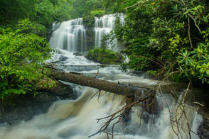
Nearly every tributary of the Wild and Scenic Chattooga River has waterfalls of some sort. 40-foot Long Creek Falls is a particularly spectacular drop only 100 feet above the Chattooga River. Long Creek Falls is accessed by a lesser-known yet easy unofficial trail from Turkey Ridge Road (FS 755), about 1.7 miles long. The great swimming hole and large flat rocks around Long Creek Falls make it an excellent summertime destination. The Long Creek Falls Trail additionally passes a steep side path to a seldom-visited cascading waterfall on Pinckney Branch called Homer's Falls. Flowing only in wet weather, Homer's Falls flows 20 feet through an incredibly lush and mossy rock grotto before emptying into the Chattooga River. Hikers who go to Long Creek Falls even have the option of making a side trip to the top of Raven Rock Cliff, a 100-foot cliff that towers over the Chattooga River and features great gorge views. This hike occurred on Saturday, May 19th, 2018. My plan was to hike out and back to Long Creek Falls from the end of FS 755, making the side trip to Homer's Falls along the way.
0 Comments
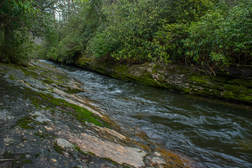
Above Ellicott Rock, the famous Wild & Scenic Chattooga River is wilder, steeper, and less-frequented. A separate stand-alone section of the Chattooga River Trail, not connected to the trail's main course from Ellicott Rock southward, travels several miles along the river between Whiteside Cove Road and Bullpen Bridge. This section of the Chattooga River Trail may actually be its most scenic, with numerous views of whitewater rapids interrupted by tranquil pools on the river. In addition, the trail passes near three unique sets of narrows on the river, one of which meets the definition of a true slot canyon. The trailside upper narrows are right by the confluence of Norton Mill Creek, featuring its own picturesque cascades. In addition, a series of spur paths and a short bushwhack leads more adventurous hikers to a scenic 25-foot waterfall on Cane Creek, another tributary of the Chattooga. This hike occurred on Saturday, February 24th, 2018. My plan was to hike the Chattooga River Trail out and back from Whiteside Cove Road to Cane Creek, from where I'd follow unofficial trails to Cane Creek Falls. This trail report additionally includes information about an alternate, short access to Cane Creek Falls, as well as about a seldom-visited waterfall on the Chattooga River itself called Corkscrew Falls.
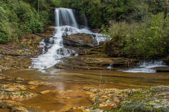
A major tributary of the Chattooga River, Scotsman Creek runs alongside Bull Pen Road and drops over three waterfalls on its way to the river. The highlight is Scotsman Falls, an impressive 45-foot waterfall where the stream first free-falls over a sheer ledge and then cascades down a stairstep rock face. Near the base of Scotsman Falls, the creek splits around a densely-vegetated island. As the forks rejoin, Scotsman Creek tumbles swiftly out of sight, shortly coming over the less scenic Lower Scotsman Falls before dumping into the Chattooga. A steep path leads to Scotsman Falls from Bull Pen Road. The path is quite short and easy to follow, although visitors will need to make a rough, muddy scramble at the end. This hike occurred on Saturday, February 24th, 2018. My plan was to hike out and back to Scotsman Falls before embarking on a longer hike along the Chattooga River Trail later in the day.
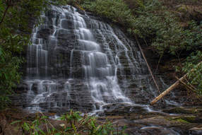
The Ellicott Rock Wilderness Area covers over 8000 acres across Georgia, South Carolina, and North Carolina. The wilderness's namesake is Ellicott Rock, located in the very heart of the wilderness at the point where all three states come together. From Burrells Ford, one can follow the Chattooga River Trail north into the wilderness all the way to Ellicott Rock and beyond. Besides passing Spoonauger Falls, the Chattooga River Trail affords numerous views of the river that it closely follows all the time. The other waterfall in the vicinity of Burrells Ford, King Creek Falls, is also easily-accessed and is among the most breathtaking waterfalls of the region. Intrepid waterfall chasers can also pick up the Bad Creek Trail from Ellicott Rock and make a challenging bushwhack to a secluded and pristine waterfall on Fowler Creek. This hike occurred on Saturday, January 27th, 2018. My plan was to first hike the Foothills Trail from Burrells Ford Campground to King Creek Falls. Then, I'd take the King Creek Trail and connect to the Chattooga River Trail. I'd follow the Chattooga River Trail north into the Ellicott Rock Wilderness all the way to Ellicott Rock, making the side trip to Spoonauger Falls along the way. From Ellicott Rock, I would follow the Bad Creek Trail and bushwhack down to Fowler Creek Falls. I would retrace most of my steps from Fowler Creek Falls, but when I would return to the vicinity of Spoonauger Falls, I would take the Foothills Trail straight to Burrells Ford Campground.
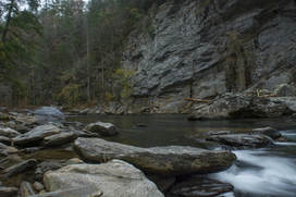
Raven Rock Cliff is a spectacular rock formation that towers over 100 feet above the Wild & Scenic Chattooga River. The well-maintained Raven Rock Trail makes a moderate descent into the Chattooga River Gorge from the end of FS 511B, terminating right across from Raven Rock Cliff - one of the most beautiful spots along Section Four of the Chattooga River. An easy rock scramble upstream will bring you to Raven Chute, a Class IV rapid stretching across the river. In the warm season when the water is high enough, it is fun to watch kayakers negotiate the rapid. This hike occurred on Saturday, November 18th, 2017. My plan was to hike out and back along Raven Rock Trail to the Raven Rock Cliff.
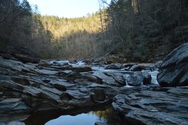
The Chattooga Wild & Scenic River is known for its lengthy and very beautiful gorge, full of rapids and waterfalls. The Canyon of Five Falls is the cream of the crop, the king of them all, perhaps one of the Chattooga River's most beautiful sections. In this 0.1-mile stretch, the river rushes over five significant Class IV or Class V rapids through a gorge full of house-sized boulders. Perhaps the most notable rapid of all is the Crack-in-the-Rock Rapid, where the mighty Chattooga River roars through three tiny slots in a line of huge boulders. In the hot weather and lower water levels of summer, this short but time-consuming hike is perfect. This hike occurred on Saturday, March 18th, 2017. My plan was to hike the Watergauge Trail, also known as the Camp Creek Trail, from the end of Watergauge Road to the trail terminus at the confluence of Camp Creek with the Chattooga River. From there, I would rock hop and wade along the Chattooga River to the Canyon of Five Falls. I would return the same way.
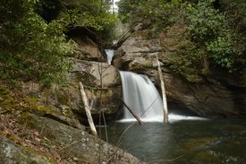
Deep in Rabun County is a spot known as Three Forks, where three major mountain waterways - Big Creek, Overflow Creek, and Holcomb Creek - come together to form the West Fork of the Chattooga River. Three Forks is a unique and pristine location that can only be reached by foot, but while Three Forks alone would be a hiking destination as worthwhile as any, the three creeks that tie into Three Forks are loaded with waterfalls that come in all shapes and sizes. Perhaps the most incredible one of them all is Thunder Dome Falls on Big Creek, a monster waterfall that falls 70 feet in multiple tiers through a slot canyon and into a deep pool. It can safely be assumed that Thunder Dome Falls is among Georgia's most jaw-dropping natural sights. Thunder Dome Falls is not matched in size by the other waterfalls on this hike, but even though they're smaller, all of them are just as picturesque. This hike occurred Saturday, March 11th, 2017. My plan was to hike the Big Creek Circuit clockwise from Highway 28, hiking the Big Creek Trail first and then the Three Forks Trail. Along the way, I would make side trips to each of the four waterfalls on Big Creek, to Three Forks and the Holcomb Creek slot canyon, and to Singley's Falls on Overflow Creek.
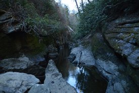
The definition of the term slot canyon is "a narrow canyon formed by the wear of water rushing through rock". These unique canyons are fairly common in the Desert Southwest sector (such as in Utah or Arizona) of the United States. What if I told you that there is a slot canyon, or several, in southwest North Carolina? Are you baffled yet? It is actually the truth, as there are a few isolated and very rare slot canyons on some of the mountain rivers and creeks in southwest North Carolina and adjacent portions of extreme northeast Georgia. At the Upper Chattooga River Slot Canyon, the mighty river gets squeezed into an unusually deep and very picturesque alleyway that is no more than a few feet wide. Two small but photogenic waterfalls act as bonuses to this already excellent hike. There might still be more slot canyons out there in the Blue Ridge Mountains, waiting for their turns to be discovered and introduced to the public. This hike occurred on Saturday, February 25th, 2017. My plan was to hike the Chattooga River Trail out and back from Bullpen Bridge to a goat path that would take me to the Chattooga River, from where I'd walk upstream to Whoa Nellie! Sieve and the Upper Chattooga River Slot Canyon. After the hike, I would make the scramble to Potholes Falls at Bullpen Bridge.
Chattooga River Trail: Sandy Ford Road to Dicks Creek Falls to Russell Bridge, Clayton, Georgia1/12/2017 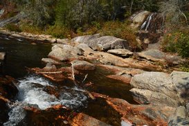
The Chattooga Wild and Scenic River is one of the longest and largest remaining wild waterways in the southeastern US, with no dams and very little human development for all of its length down to Lake Tugaloo. In fact, it is the only wild and scenic river east of the Mississippi River that is actually commercially rafted. For nearly twenty miles, the Chattooga River Trail stays near the river or even follows it along its Georgia side. Unfortunately, the Georgia Chattooga River Trail leaves something to be desired, as there are surprisingly few views of the river throughout the length of the trail. Still, the Chattooga River Trail passes by several points of interest, including Dicks Creek Falls on Section Two. This hike occurred on Saturday, November 5th, 2016. My plan was to hike the Chattooga River Trail from the Sandy Ford Road/Dicks Creek Falls trailhead to the Russell Bridge Trailhead. This is also known as Section Two of the Chattooga River Trail. Along the way, I would take side trips to Dicks Creek Falls and Adline Ford. I arranged to have two cars for this point-to-point hike: one car was placed at the Sandy Ford Road trailhead, and another car was placed at Russell Bridge on Highway 28.
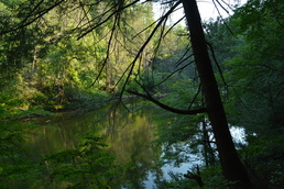
While this hike is actually in Georgia, the parking for it is in South Carolina, and you'll walk across the state line as you cross the Highway 76 bridge across the Chattooga River. In fact, the entire hike stays close to the state line. This is because the Chattooga River straddles the Georgia/South Carolina border for much of its length. The Chattooga River is a federally designated Wild and Scenic River. It is a whitewater kayaker's paradise, as there are many Class IV and Class V rapids throughout the river's course. In fact, you will get up close to Bull Sluice - a Class V rapid - on this hike, and you may even see some kayakers make their way down it. Leaving Bull Sluice, this hike will follow the Chattooga River Trail across a number of ridges near the river. Along the way, you'll be treated to several good views of this mountain river. This hike occurred on Saturday, June 11th, 2016. My plan was to hike the Chattooga River Trail from the Highway 76 bridge to Sandy Ford Road, making the short side trip to Bull Sluice along the way. I arranged to have two cars for this point-to-point hike: one car was placed at the Highway 76 trailhead and another car was placed at the Sandy Ford trailhead.
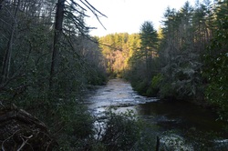
Big Bend Falls is one of the most powerful waterfalls in Upstate South Carolina. Located on the Chattooga Wild and Scenic River, the falls is one big mass of rapid whitewater, tumbling around 30 feet. To the east of the river, the Chattooga Ridge separates the main waterway from Cheohee Valley, which is a large area that lies at the base of the Cherokee Foothills. Several streams tumble down the steep eastern slopes of Chattooga Ridge, and a couple of these streams create several wonderful waterfalls that can be reached from the Winding Stairs Trail. This hike occurred on Saturday, April 4th, 2015. My plan was to hike the Winding Stairs Trail, the Big Bend Trail, and the Foothills Trail from the end of the Big Bend Trail to Cheohee Road. Since this isn't a loop and I didn't have a shuttle vehicle, I would finish with several miles of roadwalk on Cheohee Road.
|
About MeMark Oleg Ozboyd Dear readers: I have invested a tremendous amount of time and effort in this website and the Georgia Waterfalls Database the past five years. All of the work that has gone in keeping these websites updated with my latest trip reports has almost been like a full-time job. This has not allowed me to pick up a paid job to save up money for college, and therefore, I I've had to take out loans. If you find the information on this website interesting, helpful, or time-saving, you can say "thanks" and help me out by clicking the button above and making a contribution. I will be very grateful for any amount of support you give, as all of it will apply toward my college tuition. Thank you!
Coming in 2022-2023?
Other Hiking WebsitesMiles HikedYear 1: 540.0 Miles
Year 2: 552.3 Miles Year 3: 518.4 Miles Year 4: 482.4 Miles Year 5: 259.9 Miles Archives
March 2021
Categories
All
|

 RSS Feed