HIKING THE APPALACHIANS AND BEYOND
  • Home
  • Trail Reports
    • Best Hikes
    • Hikes with Scenic Views
    • Hikes with Water Features
    • Alabama
    • Georgia
    • Florida
    • North Carolina
    • South Carolina
    • Tennessee
    • Vermont
    • Virginia
  • Map
  • Hike List
  • Testimonials
  • Resources
  • Contact Us
  • Southeast Nature Society
    • Our Team
  • Georgia Waterfalls Database

Blood Mountain Wilderness: Steeltrap Knob Vista Trail, Appalachian Trail to Preachers Rock, and Dockery Lake Trail to Twin Falls and Martha's Falls, Suches, Georgia

11/10/2017

0 Comments

 
Picture
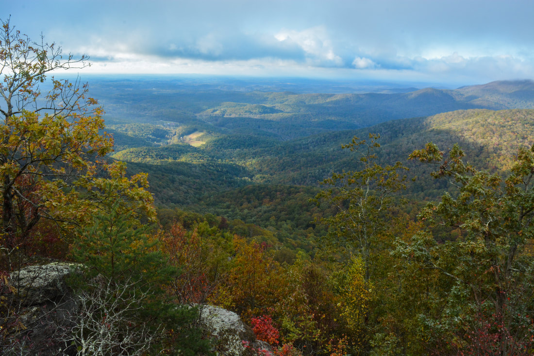
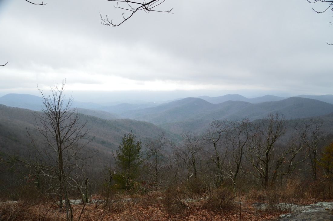
Preachers Rock is a well-known destination along the Appalachian Trail on Big Cedar Mountain that features a great view of the Blood Mountain Wilderness. A couple of other trails in the area can be utilized to create a loop hike from either Chestatee Overlook (on Highway 60) or Dockery Lake, visiting one other vista as well as up to three waterfalls. The unofficial Steeltrap Knob Trail provides a useful connection between Chestatee Overlook and Woody Gap, at the same visiting a spectacular view of the Georgia Piedmont from little-known cliffs on the side of Steeltrap Knob. Meanwhile, the Dockery Lake Trail travels through the Pigeon Roost Creek Valley between Dockery Lake and the Appalachian Trail. While no waterfalls are right on the trail, visiting Martha's Falls, Twin Falls, and Dockery Lake Falls will require only short off-trail diversions. This hike occurred on Sunday, October 29th, 2017. My plan was to hike a loop from Chestatee Overlook, starting with the Steeltrap Knob Trail and stopping by the Steeltrap Knob Vista along the way. I would then take the Appalachian Trail over Big Cedar Mountain and to the Dockery Lake Trail, stopping by several views from Big Cedar Mountain along the way, including Preachers Rock. Next, I would take the Dockery Lake Trail to Dockery Lake, visiting Twin Falls, Martha's Falls, and Dockery Lake Falls along the way. I would conclude the hike with a walk up Dockery Lake Road back to Highway 60 and Chestatee Overlook.


Read More
0 Comments

Chattahoochee National Forest: Little Cedar Mountain Vista and Waterfalls of Canada Creek via Highway 60 Trailhead, Suches, Georgia

10/10/2017

2 Comments

 
Picture
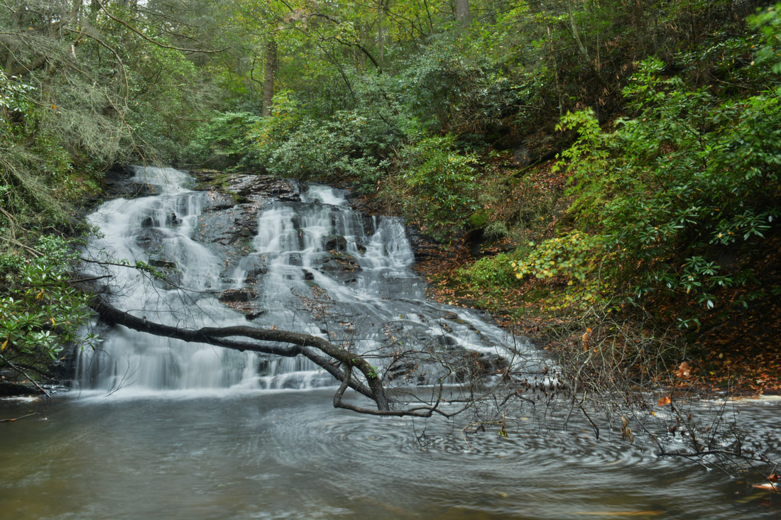
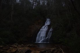
While the views atop Big Cedar Mountain along the Appalachian Trail are well-known, its lower brother Little Cedar Mountain on the other side of the quaint community of Suches is far more obscure. Despite this, a good trail leads to Little Cedar Mountain, where a set of cliffs provides a great view into the Canada Creek valley. The picturesque view is only the beginning though - a connecting trail leads deep into the Canada Creek valley, where a set of four breathtaking waterfalls await. Ranging from only 15 to over 50 feet high, all four waterfalls are fairly easy to reach thanks to an intricate network of unofficial trails along forest roads and fainter paths up and down the Canada Creek watershed. This hike occurred on Saturday, October 7th, 2017. My plan was to hike from Highway 60 to the vista atop Little Cedar Mountain. From there, I would scout out one route down into the Canada Creek valley and another on my way back (as I learned, only one route had a trail). Once in the valley, I would follow trails to Canada Creek Falls, Ontario Falls, and Alberta Falls, and if time permitted, Yukon Falls too. 


Read More
2 Comments

Chattahoochee National Forest: Upper Canada Creek Loop to Yukon Falls and Alberta Falls, Suches, Georgia

7/24/2017

0 Comments

 
Picture
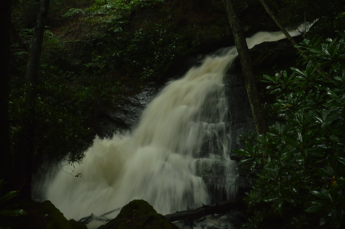
Canada Creek is one of my favorite mountain streams in North Georgia, due to a perfect combination of beauty, remoteness, and ease of access at each of the creek's four scenic waterfalls. A network of unofficial trails used by fishers and hunters weave around Canada Creek and provide fairly easy access to each of its waterfalls. The hikes to each particular waterfall aren't too long, but seeing all of the waterfalls together will take a good part of the day. A topographic map and compass are recommended for hikers who venture into the Canada Creek area, because many disorienting trail junctions are found throughout the trail system, and some of the paths are faint. This hike occurred on Saturday, July 1st, 2017. My original plan was to hike out and back to Yukon Falls on Canada Creek from the Upper Canada Creek Trailhead. After seeing the roaring state of the Yukon Falls though, I decided to use a connector to access Alberta Falls on Canada Creek and then loop back using a couple of roads. 


Read More
0 Comments

Chattahoochee National Forest: Helton Creek Falls Trail, Suches, Georgia

3/15/2017

0 Comments

 
Picture
The Chattahoochee National Forest is home to many waterfalls. Some require long hikes on faint trails or trail-less woods to reach; others can be accessed by short, easy paths. The two waterfalls on Helton Creek fall into the latter category, as very little effort is needed to see these two impressive waterfalls. The groomed path to the waterfalls is well-established, with staircases and an observation deck. Keep in mind that during the hot season, the ease of access - along with the perfect swimming hole at the falls - leads to great crowds. This hike occurred on Saturday, February 11th, 2017. My plan was to hike the Helton Creek Falls Trail out and back to the upper waterfall on Helton Creek, with a short side trip to the lower waterfall on Helton Creek along the way. 


Read More
0 Comments

Appalachian Trail: Byron Herbert Reece Trailhead to Neels Gap and to Hogpen Gap via Levelland Mountain and Cowrock Mountain, Suches, Georgia

3/9/2017

2 Comments

 
Picture
One of Georgia's most scenic hikes is along the Appalachian Trail from Neels Gap to Hogpen Gap. Along this section of the AT, the famed long-distance footpath passes over several summits that offer outstanding long-range vistas. Along the way, you will first walk along the only piece of the AT that passes under a building, at the Walasi-Yi Interpretive Center. Afterwards, you will hike across Levelland Mountain, Wolf Laurel Top, Cowrock Mountain, and Wildcat Mountain, each of which has its own breathtaking view (or several). This hike occurred on Saturday, February 11th, 2017. My plan was to hike the Byron Herbert Reece Trail from US 129 to the Appalachian Trail. There, I would pick up the Appalachian Trail and follow it through Neels Gap and to Hogpen Gap. Along the way, I would make side trips to views on Levelland Mountain and Cowrock Mountain. I arranged to have two cars for this point-to-point hike: one car was placed at the Byron Herbert Reece Trailhead and another car was placed at the Hogpen Gap Trailhead.


Read More
2 Comments

Chattahoochee National Forest: Canada Creek Falls, Ontario Falls, and Alberta Falls, Suches, Georgia

2/28/2017

5 Comments

 
Picture
Folks who reside in the north Georgia Mountains are familiar with Woody Lake, a picturesque pond next to Route 60 in the community of Suches. What many of the locals are not familiar with, however, is that the stream that drains Woody Lake drops over four notable waterfalls and through a scenic gorge on its way to the Toccoa River. Three of the waterfalls can be accessed from a trailhead at the end of East Canada Creek Road, at a place where shrinking fields and old silos illustrate that a farm once prospered here. While no official trail leads to any of the waterfalls, getting to them presents only a minor navigational challenge along a series of forest roads and narrow paths worn by fellow hikers. This hike occurred on Saturday, January 21st, 2017. My plan was first to hike from the end of East Canada Creek Road downstream along Canada Creek to Ontario Falls and Canada Creek Falls. Then, I would retrace my steps and follow the creek upstream to Alberta Falls. I would save the hike to Yukon Falls for another day. 


Read More
5 Comments

Blood Mountain Wilderness: Slaughter Creek Loop and Blood Mountain via Freeman Loop, Suches, Georgia

12/20/2016

1 Comment

 
Picture
Blood Mountain is one of the best-known mountains in Georgia for a variety of reasons, including the ease of access to the great views from the several rock slabs near the summit of the peak. The easiest approach to the top is from Highway 129, but several other trails, in addition to the Appalachian Trail itself, are found in the vicinity of Blood Mountain. Two such trails - the Jarrard Gap Trail and Slaughter Creek Trail - leave the Lake Winfield Scott Recreation Area and access the AT west of Blood Mountain. Another trail, the Freeman Trail, winds around hollows on the south side of Blood Mountain, providing a tricky passage through numerous boulder fields. You'll walk all of these trails as you hike to Blood Mountain using the "back way". This hike occurred on Saturday, October 15th, 2016. My plan was to hike the Jarrard Gap Trail from Lake Winfield Scott to the Appalachian Trail, from where I would follow the AT to the Freeman Trail, taking the spur trail to Woods Hole Shelter. Then, I would take the Freeman Trail around the south side of Blood Mountain, before meeting the Appalachian Trail again and following it to the top of Blood Mountain. I would finish the hike by descending on the Appalachian Trail to the Slaughter Creek Trail and taking the Slaughter Creek Trail back to Lake Winfield Scott.


Read More
1 Comment

Appalachian Trail: Gooch Gap to Preaching Rock, Suches, Georgia

10/1/2014

1 Comment

 
Picture
The Appalachian Trail's southern terminus is located on Springer Mountain, Georgia. As the AT leaves the mountain, it traverses a watery valley, known as Three Forks, and then proceeds to follow long, dry ridgelines for the better of the next 30 miles.  This hike is a prime example of the Georgia Appalachian Trail. Expect some views and some people - and a relatively easy hike. This hike occurred on Saturday, September 20th, 2014. My plan was to follow the Appalachian Trail, from Gooch Gap, north over Ramrock Mountain, through Woody Gap, and to Preaching Rock Overlook on the slopes of Big Cedar Mountain. 


Read More
1 Comment

    About Me

    Mark Oleg Ozboyd
    I'm an avid outdoor explorer and a hobbyist landscape photographer. I'm 21 years old and have been hiking since 2011. Originally based out of Atlanta, Georgia, I started out by occasionally hiking short trails throughout well-known Georgia State Parks. During 2012 and 2013, I began to expand my trips into adjacent states, as well as into the wilder National Forest areas rather than just State Parks. Throughout the years that followed, as I slowly ran out of popular hiking trails in my area, I began to search for and hike in more seldom-visited areas. Today, you can find me out in the woods every weekend, whether it's on an official trail or bushwhacking through cross-country terrain without any paths. I now attend Washington & Lee University and am exploring Virginia and West Virginia. My other hobbies include chess, science, old music, and meteorology. I have 3 years of amateur weather forecasting experience, having studied a lot of meteorology basics over the years. I am also a student at European School of Music where I learned that music and nature have a lot in common. Listening to good music inspires me to capture nature's beauty on the camera in different aspects that also make me recall many beautiful music pieces that I've heard.​


    Dear readers: I have invested a tremendous amount of time and effort in this website and the Georgia Waterfalls Database the past five years. All of the work that has gone in keeping these websites updated with my latest trip reports has almost been like a full-time job. This has not allowed me to pick up a paid job to save up money for college, and therefore, I I've had to take out loans. If you find the information on this website interesting, helpful, or time-saving, you can say "thanks" and help me out by clicking the button above and making a contribution. I will be very grateful for any amount of support you give, as all of it will apply toward my college tuition. Thank you! 

    Enter your email address to subscribe for trail reports:

    Delivered by FeedBurner


    Picture
    Coming in 2022-2023?

    Other Hiking Websites

    DWHike's Adventures
    Florida's Natural Wonders
    Florida Trailblazer
    Meanderthals
    Mountain Images
    by Bernie Boyer

    North Carolina Waterfalls with
    ​Kevin Adams
    Take-a-Hike!
    Tennessee Landforms
    Waterfall Page
    Waterfall Adventurer
    Zach's Mild Adventures

    Miles Hiked

    Year 1: 540.0 Miles
    Year 2: 552.3 Miles
    ​Year 3: 518.4 Miles
    Year 4: 482.4 Miles
    Year 5: 259.9 Miles

    Archives

    March 2021
    February 2021
    January 2021
    November 2019
    October 2019
    September 2019
    August 2019
    July 2019
    June 2019
    February 2019
    January 2019
    December 2018
    November 2018
    October 2018
    August 2018
    July 2018
    June 2018
    May 2018
    April 2018
    March 2018
    February 2018
    January 2018
    December 2017
    November 2017
    October 2017
    September 2017
    August 2017
    July 2017
    June 2017
    May 2017
    April 2017
    March 2017
    February 2017
    January 2017
    December 2016
    November 2016
    October 2016
    September 2016
    August 2016
    June 2016
    May 2016
    April 2016
    March 2016
    January 2016
    December 2015
    November 2015
    October 2015
    September 2015
    August 2015
    July 2015
    June 2015
    May 2015
    April 2015
    March 2015
    February 2015
    January 2015
    December 2014
    November 2014
    October 2014
    September 2014
    August 2014
    July 2014
    June 2014
    May 2014
    April 2014
    March 2014
    February 2014

    Categories

    All
    Adel
    Adirondack Park
    Alabama
    Alfred A. Ring Park
    Allegheny Trail
    Amicalola Falls State Park
    Anniston Area
    Apalachicola Bluffs And Ravines Preserve
    Apalachicola National Forest
    Apalachicola/Port St. Joe Area
    Apopka
    Appalachian Trail
    Appling
    Art Loeb Trail
    Aska Trail System
    Bakersville
    Balm-Boyette Scrub Preserve
    Balsam Lake Recreation Area
    Bankhead National Forest
    Bartow County Parks
    Bartram Trail
    Basinger
    Beersheba Springs
    Benton
    Benton Mackaye Trail
    Berry College Trail System
    Best Hike
    Big South Fork National Recreation Area
    Black Bear Wilderness
    Black Rock Mountain State Park
    Blairsville
    Blakely
    Blood Mountain Wilderness
    Blowing Rock
    Blue Ridge
    Blue Ridge Parkway
    Boone
    Bradenton
    Bradenton Beach
    Brasstown Bald
    Brasstown Wilderness
    Brevard
    Bryson City
    Buchanan
    Bucks Pocket State Park
    Bulow Creek State Park
    Bulow Plantation Ruins State Park
    Caesars Head State Park
    Caladesi Island State Park
    Calhoun
    Camel's Hump State Park
    Cashiers
    Caspersen Beach Park
    Catfish Creek State Park
    Caves
    CC Putnam State Forest
    Cedar Point Environmental Park
    Chatsworth
    Chattahoochee National Forest
    Chattanooga
    Chattanooga Valley
    Chattooga National Wild And Scenic River
    Cheaha Wilderness
    Cherohala Skyway
    Cherokee
    Cherokee National Forest
    Chiefland Area
    Chillhowee Recreation Area
    Chipley
    Chunky Gal Trail
    Circle B Bar Reserve
    Citico Creek Wilderness
    Citrus Wildlife Management Area
    Clarkesville
    Clayton
    Cleevland
    Cleveland
    Cloudland Canyon State Park
    Cohutta Wilderness
    Collier-Seminole State Park
    Cordele
    Cornelia
    Covington
    Crestview Area
    Crew-land-and-water-trust
    Cullowhee
    Cumberland Trail
    Dahlonega
    Dalton
    Dawson Forest Wildlife Management Area
    Dawsonville
    Dayton
    De Soto National Memorial
    DeSoto State Park
    Dillard
    Double Springs
    Ducktown
    Duncan Ridge Trail
    Dunlap
    Eagle's Rest Park
    Eastpoint
    Econfina Creek Wildife Management Area
    Eglin Air Force Base
    Elizabethton
    Elkins
    Elk Knob Game Lands
    Elk Park
    Ellicott Rock Wilderness
    Ellijay
    Emerson Point Preserve
    Englewood Area
    Enota Retreat
    Erwin
    Falling Waters State Park
    Fayetteville
    Fires Creek Recreation Area
    Fire Tower
    Flint River
    Florence Area
    Florida
    Florida Caverns State Park
    Florida Trail
    Foothills Trail
    Fort Mountain State Park
    Fort Myers Area
    Fort Payne
    Fort Payne Area
    Fort Yargo State Park
    Franklin
    Franklin Delano Roosevelt State Park
    Franklin-Marion State Forest
    Frozen Head State Park
    Gainesville
    Gainesville Area
    Gatlinburg
    George Washington National Forest
    Georgia
    Georgia Veterans Memorial State Park
    Glasgow
    Gorges State Park
    Grandfather Mountain State Park
    Great Smoky Mountains National Park
    Greeneville
    Green River Game Lands
    Gruetli-Laager
    Grundy Forest State Natural Area
    GTM Reserve
    Guana River Wildlife Management Area
    Hayesville
    Helen
    Hiawassee
    High Falls State Park
    Highlands
    Highlands Scenic Highway
    Hillsborough River State Park
    Hinson Conservation & Recreation Area
    Historic Sites
    Honeymoon Island State Park
    Hot Springs
    Huntington
    Inverness Area
    Jackson
    Jasper
    Jefferson National Forest
    Joan M. Durante Park
    Jonathan Dickinson State Park
    Jones Gap State Park
    Joyce Kilmer Slickrock Wilderness
    Joyce Kilmer - Slickrock Wilderness
    Juniper Prairie Wilderness
    Kelly Park
    Keown Falls Recreation Area
    Kolomoki Mounds State Park
    LaFayette
    Lake City Area
    Lake George Wild Forest
    Lake June-in-Winter State Park
    Lakeland Area
    Lake Placid
    Lake Russell Wildlife Management Area
    Lake Wales Ridge State Forest
    Laurel Fork North Wilderness
    Leffis Key Preserve
    Leon Sinks Geological Area
    Lexington
    Lineville
    Linville
    Linville Gorge Wilderness
    Lithia Springs
    Little Frog Wilderness
    Little Manatee River State Park
    Little River Canyon National Preserve
    Longboat Key
    Long Trail
    Lookout Mountain
    Lookout Mountain Battlefield
    Lovingston
    Lula Lake Land Trust
    Lumpkin
    Maggie Valley
    Manatee Springs State Park
    Marianna Area
    Mark Trail Wilderness
    Marlinton
    Mccaysville
    McMinville
    Mentone
    Middlesex
    Mistletoe State Park
    Monongahela National Forest
    Montreat
    Mountain Bridge Wilderness Area
    Mountain City
    Mountains To Sea Trail
    Mountains-to-Sea Trail
    Mount Rogers National Recreation Area
    Myakka River State Park
    Myron B. Hodge City Park
    Nantahala National Forest
    Naples
    Naples Area
    Natural Bridge State Park
    Neal Preserve
    New Castle
    Newport
    New River Gorge National Park
    New York
    North Carolina
    Ocala Area
    Ocala National Forest
    Ocean-to-Lake Trail
    Oconee State Park
    Oconee Station Historic Site
    Okaloacoochee Slough State Forest
    Oldsmar
    Oneida
    Orlando Area
    Ormond Beach
    Oscar Scherer State Park
    Oxford
    Palatka
    Palmetto Trail
    Panama City Area
    Panthertown Valley
    Parrish
    Paynes Creek Historic State Park
    Peaks Of Otter Recreation Area
    Pigeon Crockford Mountain Wildlife Management Area
    Pigeon-Crockford Mountain Wildlife Management Area
    Pigeon-Crockford Wildlife Management Area
    Pine Mountain
    Pinhoti Trail
    Pinnacle Park
    Pisgah Civitan Park
    Pisgah National Forest
    Pittman Center
    Pond Mountain Wilderness
    Ponds/Lakes
    Prentice Cooper State Forest
    Providence Canyon State Park
    Pumpkintown
    Quick Point Nature Preserve
    Raven Cliffs Wilderness
    Reed Bingham State Park
    Reliance
    Rice Creek Conservation Area
    Riverview Pointe Preserve
    Robbinsville
    Robinson Preserve
    Rock Creek Gorge Scenic Area
    Rock Island State Park
    Rome
    Rosman
    Sale Creek
    Salem
    Salt Springs
    Saluda
    Santa Rosa Beach
    Sarasota
    Sarasota Area
    Savage Gulf State Natural Area
    Scenic Views
    Scottsboro Area
    Sebring Area
    Sewanee
    Sheltowee Trace Trail
    Shining Rock Wilderness
    Signal Mountain
    Sipsey Wilderness
    Sky Valley
    Smithgall Woods State Park
    Snowbird Backcountry Area
    Soddy Daisy
    Soddy-Daisy
    Sopchoppy
    South Carolina
    South Cumberland State Park
    Southeastern Cave Conservancy
    Southern Nantahala Wilderness
    Sparta
    Sprewell Bluff Park
    Spring City
    Spring Hill
    Springs
    Spruce Pine
    Standing Indian Backcountry Area
    St. Augustine
    St. George Island State Park
    St. Joseph Bay State Buffer Preserve
    St. Marks Area
    St. Marks National Wildlife Refuge
    Stone Mountain
    Stone Mountain Park
    Suches
    Sumatra
    Sumter National Forest
    Suwannee River
    Swallow Creek Wildlife Management Area
    Sweetwater Creek State Park
    Sylva
    Talladega National Forest
    Tallahassee Area
    Tallulah Falls
    Tallulah Gorge State Park
    Tampa Bay Area
    Tate City
    Tate's Hell State Forest
    Tea Creek Wildlife Management Area
    Tellico Plains
    Tennessee
    Thomaston
    Toccoa
    Topsail Hill State Park
    Torreya State Park
    Townsend
    Tracy City
    Tray Mountain Wilderness
    Trenton
    Triple Creek Preserve
    Troutdale
    Unaka Mountain Wilderness
    Upper Tampa Bay County Park
    Venice
    Vermont
    Virgin Falls State Natural Area
    Virginia
    Virginia Outdoors Foundation
    Vogel State Park
    Wakulla Springs State Park
    Waleska
    Walhalla
    Wartburg
    Water Features
    Waynesville
    Weedon Island Preserve
    Weeki Wachee Preserve
    Wekiwa Springs State Park
    West Palm Beach Area
    West Virginia
    Whitehall
    White Springs
    Winder
    Withlacoochee State Forest
    Young Harris

    RSS Feed

TRAIL REPORTS

Hikes in Alabama
​Hikes in Florida
Hikes in Georgia
Hikes in North Carolina
Hikes in South Carolina
Hikes in Tennessee
Hikes in Virginia

Hiking Resources

Alabama Resources
​
Florida Resources
Georgia Resources
North Carolina Resources
​South Carolina Resources
​
Tennessee Resources

Other

Contact
Map of Hikes
Alphabetical List of Hikes
Southeast Nature Society
© COPYRIGHT 2014-2018
​ALL RIGHTS RESERVED.
Important: I disclaim any responsibility for any damage or personal injury that may occur as a result of the activities and information found on this website. All outdoor activities, especially off-trail hiking, are done at your own risk. Never hike or head into that area that may be above your fitness or experience level.
  • Home
  • Trail Reports
    • Best Hikes
    • Hikes with Scenic Views
    • Hikes with Water Features
    • Alabama
    • Georgia
    • Florida
    • North Carolina
    • South Carolina
    • Tennessee
    • Vermont
    • Virginia
  • Map
  • Hike List
  • Testimonials
  • Resources
  • Contact Us
  • Southeast Nature Society
    • Our Team
  • Georgia Waterfalls Database