Virgin Falls State Natural Area: Virgin Falls Trail and Caney Fork River Trail, Sparta, Tennessee8/29/2014 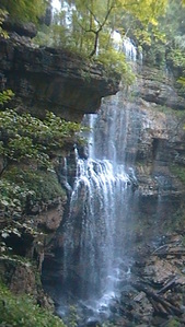 The Caney Fork River's sources are in the northern Cumberland Plateau. On its way to the Tennesee River, it cuts a dramatic gorge known as "Scotts Gulf" near Sparta, TN. The Bridgestone-Firestone Centennial Wilderness protects Scotts Gulf, and an additional tract of land is Virgin Falls State Natural Area. Virgin Falls State Natural Area protects a number of features, with the key feature known as Virgin Falls. The 110-foot high cataract is very rare - it flows out of a cave and disappears int a pit in the ground that leads into an underground cave system. Additionally, Virgin Falls State Natural Area encompasses two more, smaller waterfalls, and a great overlook of Scott's Gulf itself. This hike occurred on Saturday, August 9, 2014. My plan was to do a loop hike with the Virgin Falls Trail, Caney Fork River Trail, and a Connector leading back up to Scott's Gulf Road. Also, on the way, I would check out Sheep Cave, Big Laurel Falls, Big Branch Falls, and Martha's Pretty Point Overlook. However, the plan had to be abandoned as the Caney Fork River Trail's condition deteriorated rapidly. The result was an out and back hike on Virgin Falls Trail and an extension along the Caney Fork River Trail. R/T Length of Trail: 12 Miles Duration of Hike: 8 Hours Type of Hike: Out-and-Back with Small Loops Difficulty Rating: 8 out of 10 Pros: Several waterfalls; numerous campsites;highly marked and well-built Virgin Falls Trail; first mile of Virgin Falls Trail is flat Cons: Virgin Falls Trail is almost all uphill on the way back; poorly-marked Caney Fork Trail; very confusing network of old roads on Caney Fork Trail; dangerous, slippery ford(s) of Caney Fork River; west part of Overlook Loop Trail is closed Best Season(s) to Hike: Spring; Summer Trail Blaze Color(s): Virgin Falls Trail - White; Overlook Trail - Blue; Caney Fork River Trail - None Beginning Point: Virgin Falls Trailhead and Parking Area on Scott Gulf Road Directions: From Sparta, TN: Follow US Route 70 East until you see Wonder Lake on the left - immediately make a sharp turn right onto Eastland Road. Follow it for 5.8 miles until you reach Scott Gulf Road on the right. Turn right onto this gravel road and follow it for 2 miles until the easily-noticed trailhead and parking area on the right. if you look at the map above, you see two trails: a blue one and a red one. The blue one is the main Virgin Falls Trail, and the red one is the Caney Fork River Trail. Two completely different trails. The former is completely worth it; the latter, on the other hand, would be one I don't recommend going onto. I'll get more into detail about that soon. When you start the hike, the first thing that will catch your eyes is several notices about lost hikers, how dangerous the trail is, blah blah blah... It is definitely exaggerated if they are talking about ONLY the Virgin Falls Trail. If they include the Caney Fork River Trail, on the other hand, the warnings do it justice. it seemed to me like they were talking about mainly the Virgin Falls Trail though. Anyway, enough with the warnings. The trail starts off slightly downhill, but generally flat, along the plateau. It winds through a thin forest for about a mile, crossing a couple of footbridges, before approaching Big Branch. At 1.2 miles, the trail sharply turns right and crosses, via rock hop, Big Branch at 1.2 miles. On the other bank, turn left. This is the edge of the rim. The descent into the rocky stream valley begins. Right away, you'll see Big Branch Falls on the left. It is a thin cascade, maybe 20 feet high. It might be better during high water though. After this, the Virgin Falls Trail switchbacked multiple times along the side of the valley, approaching the roar of Big Laurel Creek. reach Big Laurel Creek at 1.5 miles. Here, turn left to a cable crossing of the creek. The cable isn't really needed, because you can easily use the rocks to ford. After the ford, turn left, and start descending deep into the rock-strewn valley. At 1.6 miles, you reach a junction with the Overlook Trail. Some people skip the overlook, but that's just stupid - the extra half mile is absolutely worth it. Once you turn right onto the Overlook Trail, it starts ascending right away, and at 1.7 miles, crosses a flat that looked like an old road. Then, the ascent lightens, and the trail turns left to follow the contour of the mountain. It's a little overgrown occasionally, but nothing impassable or confusing. At 1.9 miles, there was a "junction". Here, the other Overlook Trail access turned left downhill back to the Virgin Falls Trail, while the main Overlook Trail (I called it Upper Overlook Trail) beared right. However, there was a notice stating that the other Overlook Trail access was closed. Whenever it was closed, it must have been really recent, because recent descriptions still had it as open. Regardless, I decided to try the closed trail on my way back. So for now, keep following the Overlook Trail towards the rim of the plateau. Right away, the trail turned to follow the cliffs at the rim, before reaching a steep ladder that breaked through the rim. After this, the trail crossed a dried-out streambed two times around 2 miles, and gradually ascended through a thin forest. Soon, there will be a small viewpoint on the left - although this is not the main one. It's still worth checking out. Finally, at 2.1 miles, the trail ended at Martha's Pretty Point Campsite, with a path leading left to Martha's Pretty Point Overlook. And... what a view!! It is safe to say that this was the best view I have seen on the Cumberland Plateau yet. Right up front, I could see the deep gorge of the Caney Fork River, which twisted its way between the steep mountain slopes. Beyond that, higher mountains overshadowed the horizon, with the mountains of Fall Creek Falls State Park on the horizon. If I didn't have to go farther, I could have stayed here the rest of the day. From the overlook, there is no other way but to retrace your steps to arrive at the Overlook Trail access junction at 2.3 miles. Here, turn right onto the closed trail. You can still see the path, until at 2.4 miles, there is a broken ladder, and shortly afterwards, a sign "Main Trail <----". Now you can go wherever you want - your trail is way down there! For the next 0.2 miles, you can just descend straight down the hill (pretty steeply) and follow faint footprints. Wherever you go, if you go downhill, you'll get there. At 2.6 miles, reach Virgin Falls Trail. Here, turn right. The trail continues to descend amidst countless rocks. There are some beautiful views of Big Laurel Creek, a continuous cascade. At 2.7 miles, pass the top of Big Laurel Falls, and then descend steeply down to the base of Big Laurel Falls at 2.8 miles. Big Laurel Falls, while not a high waterfall, is quite a sight, especially after rain. A large, fallen tree lies in the middle of the falls, increasing the beauty of the scene. The base of the falls also houses the big Laurel Falls campsite. Honestly, I don't like campsites near creeks, because it's always too humid. I like ones that are like Martha's Pretty Point Overlook - on high ridgelines and in dry places. Anyway, at Big Laurel Falls, turn right to keep following Virgin Falls Trail. The trail quickly leaves Big Laurel Creek and proceeds to flatten out and follow the contours of a dry hillside. The next 1.1 miles are pretty monotonous, until the junction with the Virgin Falls Loop at 3.9 miles. The shorter way is going forward, but then you'll miss Sheep Cave, so turn right. The trail becomes considerably rockier as it follows the hillside. The trail will descend towards Sheep Cave, and after passing a view of the creek (which seems to disappear underground), reaches the junction with the Sheep Cave Spur at 4.2 miles. Here, turn right. It's only about 100 yards to Sheep Cave, although primarily uphill. Sheep Cave is not really a cave but rather a really large rock overhang. The creek drops from Sheep Cave down a large rock face, making a pretty, unnamed waterfall. Also, you can feel how much cooler it is in the cave then outside it. Retrace your steps to the last junction at 4.3 miles, Keep following the main trail and descend into a dry valley at 4.4 miles, only to ascend back out at 4.5 miles. Now, you can hear Virgin Falls in the distance. Reach Virgin Falls Campsite at 4.6 miles, and the 110-foot cataract itself at 4.7 miles. Virgin Falls is an amazing sight. The stream that forms the falls actually comes out of a cave, and at the bottom of the falls, disappears in Virgin Falls Pit into an underground cave system. Wow! This was tied as my all-time most favorite waterfall with Ramsey Cascades. From the viewing area, there is also a path that leads to the top of the waterfall, but I didn't take the time to go there, because I still had a long way ahead, and it was already around sunset. Had I known what I would run into at the Caney Fork, I would have rather went to the top of the falls rather than the Caney Fork River. Once you have finished viewing the remarkable sight, go downhill following white blazes and reach another junction at 4.9 miles. Here, if you want to go back to the parking lot the way you came, turn left and you'll soon get back on the trail that leads back up the valley. I planned to, and did, go forward onto the Caney Fork River Trail - little did I know that I would end up returning to this same spot. The Caney Fork River Trail descends downhill to a junction at 5 miles with a spur trail that leads to the Caney Fork River Campsite. Turn left here and follow the old road to Fish Hole Ford of the Caney Fork River at 5.2 miles. There are countless rocks before the ford that make a good footing impossible, and guess what... IN the ford too! At the edge of the water, I saw a small copperhead, but while I tried taking a picture, it disappeared under the rocks. The ford is not very deep, not even knee deep, but quite hard. You have to navigate the swift current while stepping over countless slippery rocks. I've never done a ford this hard. In the middle of the ford, I saw a lightning flash in the distance and shortly afterwards a long roll of thunder... yay me! On the other side of the river, there's a sign for the Davis Cemetery to the right. This is actually another trail that is part of the trail system where every single trail is named "Caney Fork River Trail". Anyway, bear left and keep following the old road here. Soon, there will be a well-signed junction with the Shop Gap Trail, and the confusion commences. Obviously, you have to go forward, but I don't know. Something was wrong somewhere around here. I kept following the old road for probably around a mile, maybe a bit less, and it dead-ended at the ruins of an old "hunting house"?? I don't know how to name it, but that was a dead end. Just some old ruins of a house and a river the size of a lake, with obviously no ford here. I knew that I had to cross the river at some point at Welch Ford, so I retraced my steps and tried following the river bank. Eventually, I found an almost overgrown campsite and what looked like possibly another old road that led to the river. I followed the road and the closer it got to the river, the more rocks were added again. Finally, I reached a the river before a small dam. Judging by everything I read and saw, the ford should be here or somewhere really close, but my only answer is that the trail is now overgrown. I crossed the river here in waist-deep water and more slippery rocks, but I didn't find anything on the other side. It was twilight already, so in daylight something might be seen, but there was definitely no clear trail. I did search for the ford a bit more along the riverbank but gave up soon. Now I had to go all the way back up the trail I came from. Ugh. However, I soon learned that even getting out of here was harder than it seemed. I wandered all over the flats along the riverbank, so it took me nearly an hour to find the road back to Fish Hole Ford. By now, thunder and lightning were every 5 seconds, although still no rain. The lightning was lighting up the forest like during daylight. Eventually, I got back over the river and back to the Virgin Falls Trail. The trail that turns here back to finish the small loop is very steep. It's about 0.5 miles long and all uphill. No switchbacks, just steep. It might have been the steepest part of the hike. As I reached the trail that I was on, the downpour started, and never ended until the end of the hike. It took me until midnight to finally get back to the parking area, with 3 more miles and 2 more hours of hiking then I had planned under my belt. To summarize this hike: all of the Virgin Falls Trail is an excellent hike, with many rewards. It is one that shouldn't be missed by Cumberland Plateau hikers. However, once it comes to the Caney Fork River Trail, it is completely opposite. For your safety, I do not advise you to go on that trail unless you REALLY know where you are going. One of these days I want to come back from the other side of the trail and find what happened near that ford. It's a tough call, but I think this hike deserves to be a "Best Hike". Even with the poor quality of the Caney Fork River Trail, it is still a best hike. Virgin Falls is absolutely astounding. Below are my pictures and videos. Also, please note I forgot the battery for my camera, so I had to use my video camera for pictures. Thus, the picture quality is relatively poor.
0 Comments
Leave a Reply. |
About MeMark Oleg Ozboyd Dear readers: I have invested a tremendous amount of time and effort in this website and the Georgia Waterfalls Database the past five years. All of the work that has gone in keeping these websites updated with my latest trip reports has almost been like a full-time job. This has not allowed me to pick up a paid job to save up money for college, and therefore, I I've had to take out loans. If you find the information on this website interesting, helpful, or time-saving, you can say "thanks" and help me out by clicking the button above and making a contribution. I will be very grateful for any amount of support you give, as all of it will apply toward my college tuition. Thank you!

Coming in 2022-2023?
Other Hiking WebsitesMiles HikedYear 1: 540.0 Miles
Year 2: 552.3 Miles Year 3: 518.4 Miles Year 4: 482.4 Miles Year 5: 259.9 Miles Archives
March 2021
Categories
All
|
 RSS Feed