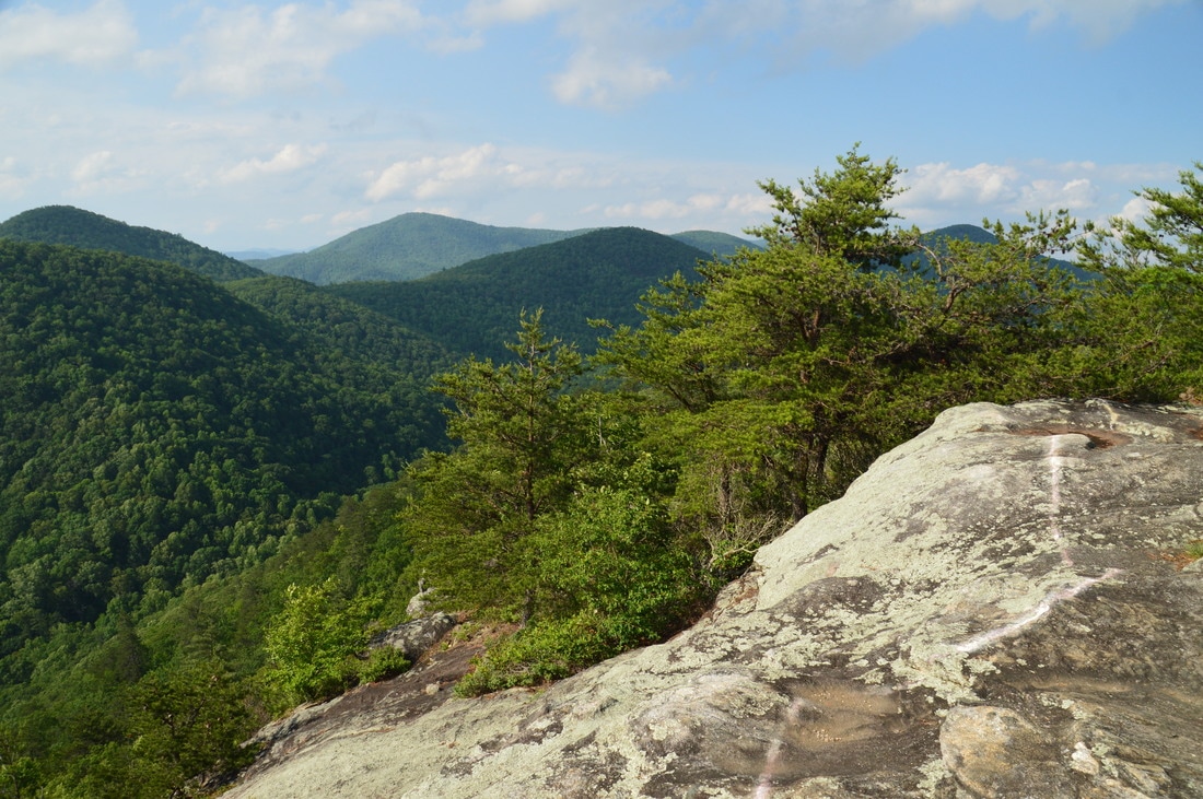
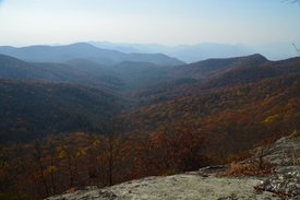
A rocky peak that towers over the Stekoa Creek valley and Clayton, Pinnacle Knob provides a 270-degree vista that is one of Northeast Georgia's best. The view from the top includes an attractive foreground of valleys and mountains with a beautiful background of fading lines of ridges. Two different hikes provide access to Pinnacle Knob: a longer hike from Warwoman Road and a shorter hike from Pinnacle Drive near US 441. While the longer route has the added benefit of passing two pretty waterfalls, the shorter route via the Courthouse Gap Trail is convenient for folks who are looking for a great payoff without a full-day hike. Furthermore, the side trail from the Bartram Trail was to the top of Pinnacle Knob was recently rerouted and lengthened to allow easier access to Pinnacle Knob's clifftop views. This hike occurred on Saturday, May 27th, 2017. My plan was to hike out and back to Pinnacle Knob via the Courthouse Gap Trail, Bartram Trail, and Pinnacle Knob Trail, starting at Courthouse Gap Road.
4 Comments
The streams that drain Warwoman Creek and the Chattooga River on the south side of Warwoman Road are generally not known for waterfalls as much as their more rugged counterparts to the north. Nevertheless, some notable exceptions exist, and Gold Mine Branch is perhaps one of the most major. On this creek, a 50-foot waterfall is stationed. No trail leads to Gold Mine Branch Falls, but despite this disadvantage, access is still fairly easy from Willis Knob Road, and with a couple of correct navigational decisions, one will get to the base of the falls in less than 30 minutes. This hike occurred on Saturday, May 27th, 2017. My plan was to hike off-trail out and back to the base of Gold Mine Branch Falls from Willis Knob Road via the most direct and recommended route.
Sarahs Creek is one of a handful of remote streams that drain the slopes of Rabun Bald, Georgia's second highest peak. Most of those streams form noteworthy waterfalls, but while some - such as Holcomb Creek Falls - are popular, others like the two waterfalls on Sarahs Creek are hardly known about. The hike from the end of Forest Road 155C to Upper and Lower Sarahs Creek Falls is fairly easy, but it does entail sections of creek-walk and minor bushwhacking in addition to navigating along faint paths. Those who reach both waterfalls will be rewarded with an interesting upper waterfall in a canyon flanked by a very tall cliff and a pristine lower waterfall that drops around 70 feet. This hike occurred on Saturday, May 27th, 2017. My plan was to hike the gated part of FS 155C from the gate to a faint trail that descended into the Sarahs Creek valley. I would follow the trail for some time, before leaving the trail and bushwhacking down to Sarahs Creek, and hike up the creek to Upper Sarahs Creek Falls. Finally, I would return to the trail and follow it down to Lower Sarahs Creek Falls. I would return the same way.
Chattahoochee National Forest: Mill Shoals and Big Shoals on Stekoa Creek, Clayton, Georgia4/6/2017 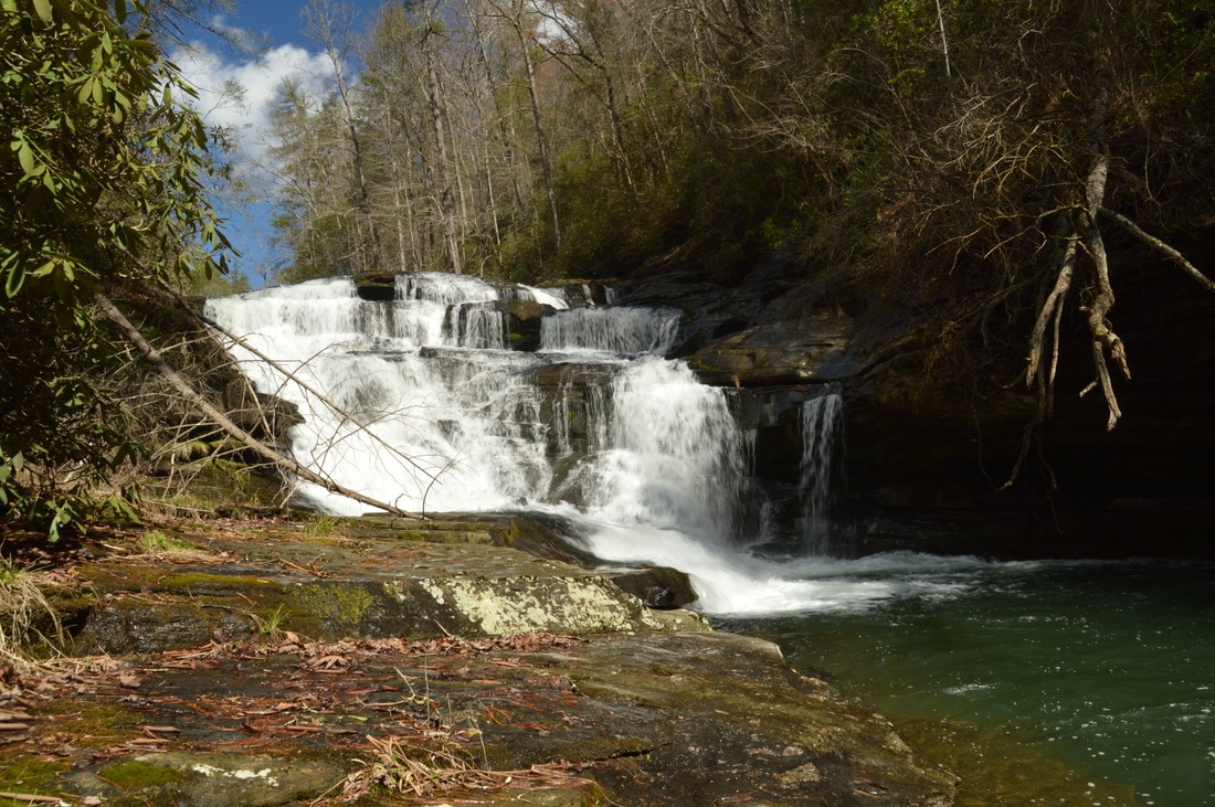
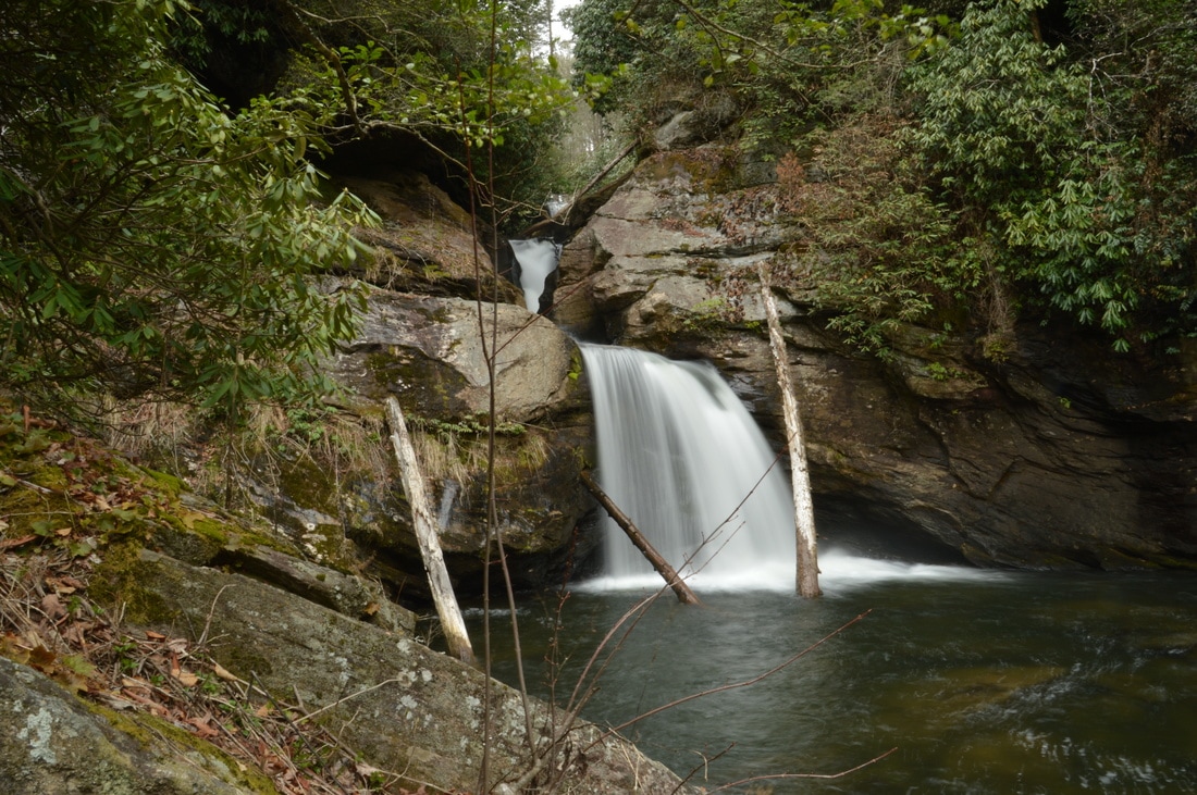
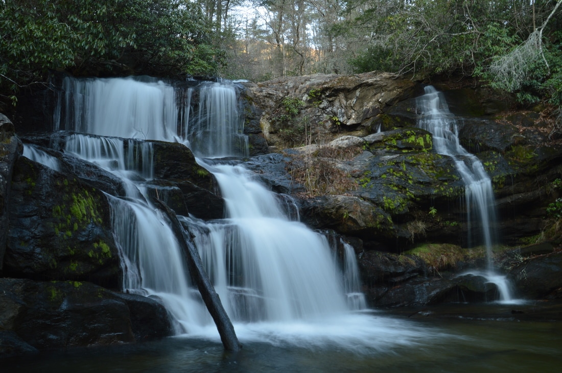
Stekoa Creek is one of the largest tributaries of the Chattooga River, flowing through the town of Clayton and the lower elevations of Rabun County. Most of the creek - including several of its notable waterfalls - is on private land. However, the lower mile and a half of Stekoa Creek flows through mostly National Forest property. In this public stretch of the creek, there are two notable waterfalls - Mill Shoals and Big Shoals - with respective heights of 27 feet and 35 feet, and getting to the waterfalls is fairly easy. Unfortunately, a headline bigger than waterfalls for Stekoa Creek is its poor water quality, due to drainage issues in Clayton. This hike occurred on Saturday, March 18th, 2017. My plan was to hike out and back from Wolf Creek Church Road to Mill Shoals and then Big Shoals on Stekoa Creek.
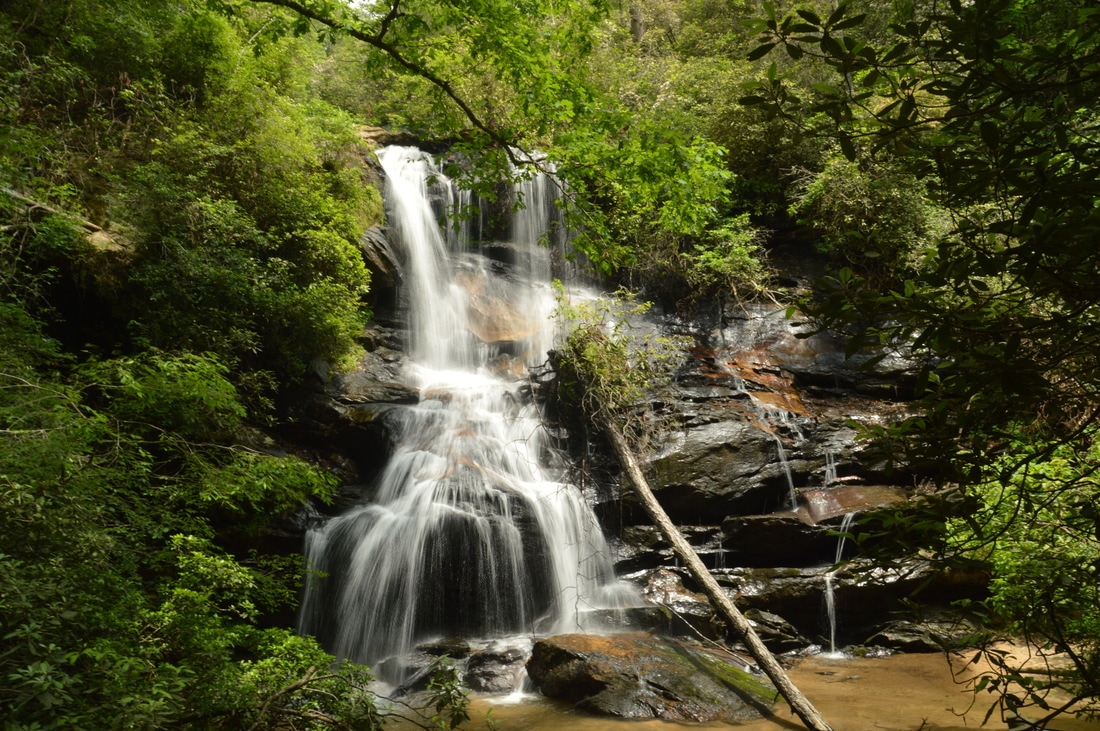
Deep in Rabun County is a spot known as Three Forks, where three major mountain waterways - Big Creek, Overflow Creek, and Holcomb Creek - come together to form the West Fork of the Chattooga River. Three Forks is a unique and pristine location that can only be reached by foot, but while Three Forks alone would be a hiking destination as worthwhile as any, the three creeks that tie into Three Forks are loaded with waterfalls that come in all shapes and sizes. Perhaps the most incredible one of them all is Thunder Dome Falls on Big Creek, a monster waterfall that falls 70 feet in multiple tiers through a slot canyon and into a deep pool. It can safely be assumed that Thunder Dome Falls is among Georgia's most jaw-dropping natural sights. Thunder Dome Falls is not matched in size by the other waterfalls on this hike, but even though they're smaller, all of them are just as picturesque. This hike occurred Saturday, March 11th, 2017. My plan was to hike the Big Creek Circuit clockwise from Highway 28, hiking the Big Creek Trail first and then the Three Forks Trail. Along the way, I would make side trips to each of the four waterfalls on Big Creek, to Three Forks and the Holcomb Creek slot canyon, and to Singley's Falls on Overflow Creek.

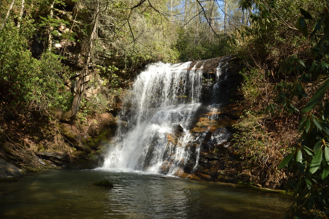
A major tributary of Big Creek, Talley Mill Creek originates just across the state line near Highlands and flows into Georgia through mostly private land. However, in the final course of its run, south of Highway 28, the creek enters National Forest land and forms a beautiful waterfall that cascades 45 feet down a steep rock ledge. The falls is surprisingly little-visited and not well-known in the hiking community, despite its proximity to the road and ease of access. In fact, an old logging road leads almost all of the way to the waterfall, and a faint path created by occasional previous hikers serves as the final leg of the hike. This hike occurred on Saturday, March 11th, 2017. My plan was to hike out and back to Talley Mill Creek Falls from Highway 28, following the route of least resistance (which turned out to be very easy to find).
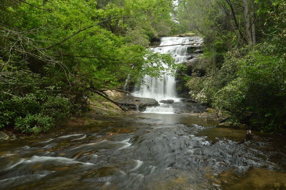
The Hemlock Falls Trail is one of Georgia's most popular streamside trails, and for good reason: the trail follows beautiful Moccasin Creek, which is a constant run of whitewater nearly all of its length, culminating in Hemlock Falls, a pretty 15-foot waterfall with a pool. Above Hemlock Falls, however, lies a much less-visited world. Above Hemlock Falls, a remote and unmaintained footpath crosses the creek and continues through a picturesque gorge with many cascades and slides, before terminating at Upper Moccasin Creek Falls, a 40-foot waterfall that is widely considered to be one of Georgia's most beautiful waterfalls. This hike occurred on Saturday, March 4th, 2017. My plan was to hike the Hemlock Falls Trail and the unmaintained footpath that follows from the Moccasin Creek Trailhead to Upper Moccasin Creek Falls and back, passing Hemlock Falls on the way.
 Often, it is disappointing that some most photogenic waterfalls are located on private land. In some isolated cases, the owners are generous enough to allow the public to visit, but unfortunately, the majority of the time, such waterfalls are strictly off-limits. Timpson Creek Falls is one of those private waterfall. This single-drop 40-foot waterfall is quite a beauty. This hike occurred on Saturday, March 4th, 2017. My plan was to hike a well-established old forest road, sometimes referred to as the Timpson Creek Trail, out and back to Timpson Creek Falls from Forest Road 162 (Timpson Creek Road). This was back when I thought the entire trail from FR 162 is public land. UPDATE 9/3/2022: I have become aware that this waterfall is actually located on private land, just barely outside the National Forest. The Rabun County property tax map had previously been erroneous and had led me to believe the waterfall is publicly-accessible when it's not. Thus, I have removed the GPS coordinates for the waterfall. It may be possible to visit the waterfall with permission. If you happen to gain access, please keep in mind that 1) the short scramble path to the base of the falls is steep and slick, and 2) the owner asks to leave no trace and carry out any trash you find.
I have thus redacted the directions below. 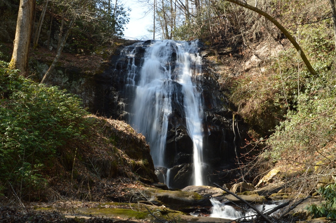
Plumorchard Creek is one of a handful of mountain streams that drain the east side of the Tennessee Valley Divide and flow into the Tallulah River. Most of these streams quickly leave the mountaintops and are already in the valleys by the time they grow large. However, Plumorchard Creek is an exception. This stream tumbles 65 feet over a single-drop waterfall that flows down a steep cliff only a mile west of the Tallulah River. This hike occurred on Saturday, March 4th, 2017. My plan was to make an exploratory bushwhack from Plum Orchard Road to a location on Plumorchard Creek that I was highly confident in being home to an undocumented tall waterfall. As it turned out, the waterfall was there, and the hike was only a partial bushwhack (the first part followed gated forest roads).
The Bartram Trail, which is a lesser-used footpath that stretches across portions of Georgia and North Carolina, stays close to the Tennessee Valley Divide for a number of miles in Georgia's Rabun County, passing over Rabun Bald, which is the second highest mountain in Georgia. In the vicinity, several other mountains provide noteworthy views, such as Double Knob, Flat Top Mountain, and Flint Knob. While the views from Rabun Bald are arguably better than some of these views, the other overlooks in the area are certainly worth visit as well. On this hike, you'll follow the Bartram Trail and then a side trail to three or four mountains with views in different directions. If you're feeling up to it, you will have the opportunity to tackle Rabun Bald and experience the 360-degree view from the top as well. This hike occurred on Saturday, November 12th, 2016. My plan was to hike the Bartram Trail out and back from Wilson Gap Road to Rabun Bald. Along the way, I would make the side trip to Flint Knob and possibly Alex Mountain, and I would also bushwhack up to Double Knob, in addition to seeing the view from Flat Top Mountain. Unfortunately, due to the length of the side trips, I was not able to hike the Bartram Trail from Flint Gap to Rabun Bald.
Chattooga River Trail: Sandy Ford Road to Dicks Creek Falls to Russell Bridge, Clayton, Georgia1/12/2017 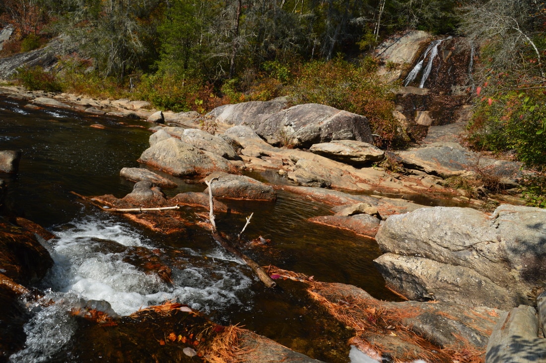
The Chattooga Wild and Scenic River is one of the longest and largest remaining wild waterways in the southeastern US, with no dams and very little human development for all of its length down to Lake Tugaloo. In fact, it is the only wild and scenic river east of the Mississippi River that is actually commercially rafted. For nearly twenty miles, the Chattooga River Trail stays near the river or even follows it along its Georgia side. Unfortunately, the Georgia Chattooga River Trail leaves something to be desired, as there are surprisingly few views of the river throughout the length of the trail. Still, the Chattooga River Trail passes by several points of interest, including Dicks Creek Falls on Section Two. This hike occurred on Saturday, November 5th, 2016. My plan was to hike the Chattooga River Trail from the Sandy Ford Road/Dicks Creek Falls trailhead to the Russell Bridge Trailhead. This is also known as Section Two of the Chattooga River Trail. Along the way, I would take side trips to Dicks Creek Falls and Adline Ford. I arranged to have two cars for this point-to-point hike: one car was placed at the Sandy Ford Road trailhead, and another car was placed at Russell Bridge on Highway 28.
While this hike is actually in Georgia, the parking for it is in South Carolina, and you'll walk across the state line as you cross the Highway 76 bridge across the Chattooga River. In fact, the entire hike stays close to the state line. This is because the Chattooga River straddles the Georgia/South Carolina border for much of its length. The Chattooga River is a federally designated Wild and Scenic River. It is a whitewater kayaker's paradise, as there are many Class IV and Class V rapids throughout the river's course. In fact, you will get up close to Bull Sluice - a Class V rapid - on this hike, and you may even see some kayakers make their way down it. Leaving Bull Sluice, this hike will follow the Chattooga River Trail across a number of ridges near the river. Along the way, you'll be treated to several good views of this mountain river. This hike occurred on Saturday, June 11th, 2016. My plan was to hike the Chattooga River Trail from the Highway 76 bridge to Sandy Ford Road, making the short side trip to Bull Sluice along the way. I arranged to have two cars for this point-to-point hike: one car was placed at the Highway 76 trailhead and another car was placed at the Sandy Ford trailhead.
 The Bartram Trail was created to extend from Northeast Georgia to Southwest North Carolina in the footsteps of the traveler William Bartram. His book, "The Travels of William Bartram", describes both his travels across the Southeast and the flora and fauna that he discovered in this area. In 1775, he visited a lush watery valley in Northeast Georgia now known as Warwoman Dell, from where he sent specimens of the flora and fauna to London. He was one of the first main explorers of the area. The section of the Bartram Trail described in this post is a section that is surprisingly short for as much as 3 attractions. This hike occurred on Saturday, July 12, 2014. The plan was to follow the Bartram Trail from Warwoman Dell by Becky Branch Falls and Martin Creek Falls to the Pinnacle Knob Trail.. From there, I would take the Pinnacle Knob Trail to the summit of Pinnacle Knob to be treated to what was in my opinion the best view I have seen yet in Georgia.
|
About MeMark Oleg Ozboyd Dear readers: I have invested a tremendous amount of time and effort in this website and the Georgia Waterfalls Database the past five years. All of the work that has gone in keeping these websites updated with my latest trip reports has almost been like a full-time job. This has not allowed me to pick up a paid job to save up money for college, and therefore, I I've had to take out loans. If you find the information on this website interesting, helpful, or time-saving, you can say "thanks" and help me out by clicking the button above and making a contribution. I will be very grateful for any amount of support you give, as all of it will apply toward my college tuition. Thank you!

Coming in 2022-2023?
Other Hiking WebsitesMiles HikedYear 1: 540.0 Miles
Year 2: 552.3 Miles Year 3: 518.4 Miles Year 4: 482.4 Miles Year 5: 259.9 Miles Archives
March 2021
Categories
All
|
 RSS Feed