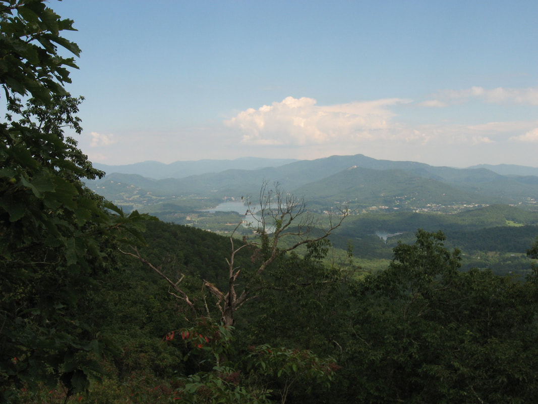
Miller Trek is one of Northeast Georgia's most underrated trails. Starting out from Brasstown Valley Resort near Young Harris, Miller Trek makes a loop on the slopes of Rocky Knob at the north end of a ridge extending from Brasstown Bald, Georgia's tallest peak. Besides the peace that this remote trail offers, it also passes a little-known spur trail to a bluff on the south side of Rocky Knob with a breathtaking 270-degree view that encompasses much of Brasstown Valley as well as Lake Chatuge, the towns of Hiawassee and Young Harris, and even the west end of Southern Nantahala Wilderness including Eagle Mountain. Adventurous hikers can continue along the ridge to tall cliffs on Cedar Knob, where more views to the west into Brasstown Valley await. This hike occurred on Monday, August 21st, 2017. My plan was to hike the Miller Trek Loop and Keys Branch Loop counter-clockwise. Along the way, I would make a side trip to Rocky Knob Bluff, where I would watch the Great American Total Solar Eclipse of 2017, and I would also continue to the clifftop views on Cedar Knob.
1 Comment
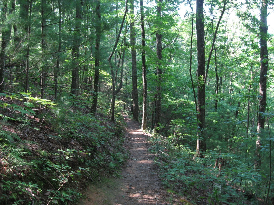
The Pinhoti Trail is a long-distance trail that runs for over 300 miles across Alabama and Georgia. Portions of it are still in the development stage, particularly in West Georgia where little public land is available. The northernmost part of the PT is in the Cohutta Mountains, where the trail is remote and little-traveled due to an overall lack of significant features. The section of the Pinhoti between Mulberry Gap Road and Highway 52 is on the southern fringe of the Cohutta Mountains is a well-constructed trail that is great for a mostly relaxing walk with good exercise. Even though this segment of the trail is a bit more popular due to its proximity to two roadways, you will still find it mostly peaceful except where it approaches Highway 52. As a bonus, a very short road-walk from the end of the segment will lead you to a grassy clearing with panoramic views of the Cohutta Mountains. This hike occurred on Saturday, August 19th, 2017. My plan was to hike out and back along the Pinhoti Trail from Mulberry Gap Road to Highway 52 and to Cohutta Overlook.
Chattahoochee National Forest: Big Thunder Falls & Canyon on Clear Creek, Sky Valley, Georgia8/29/2017 
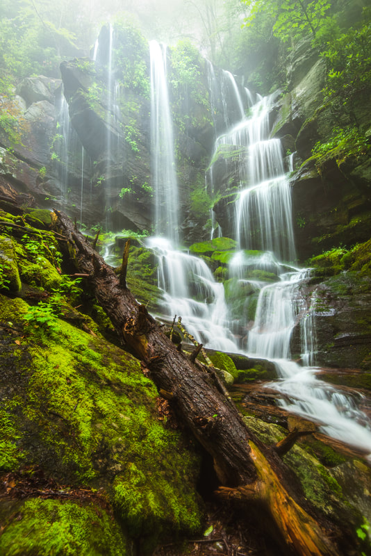
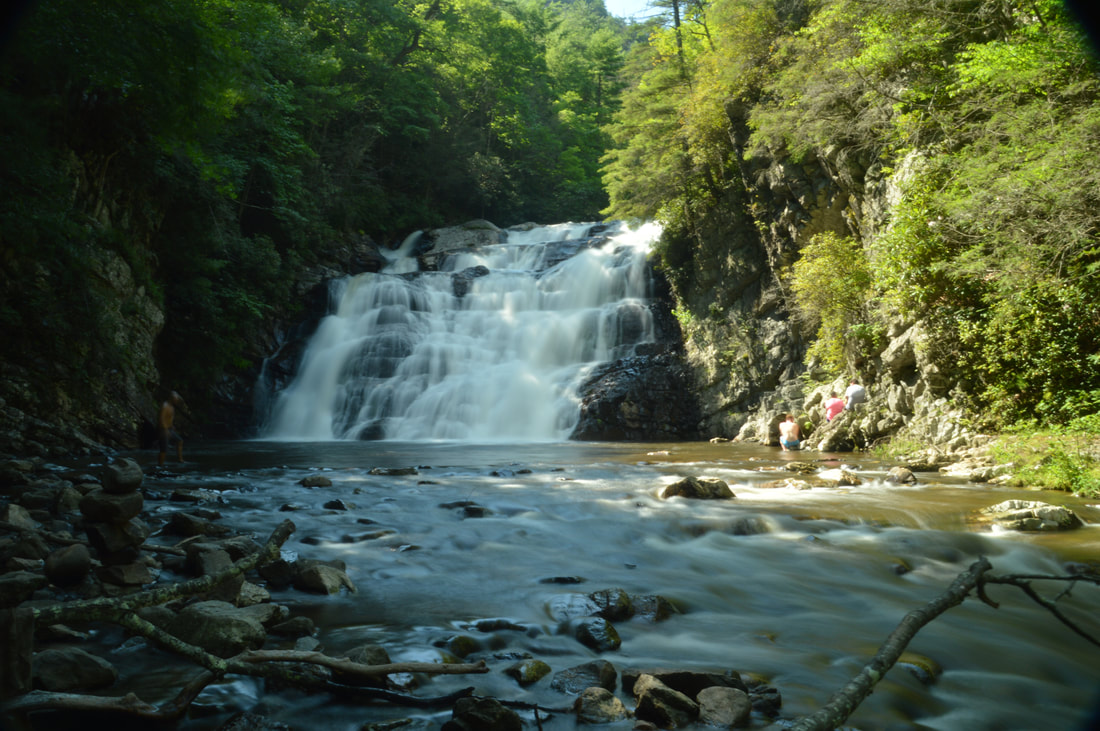
Overflow Creek in extreme northeast Rabun County is well known for its spectacular kayaking opportunities due to the creek's numerous powerful rapids and cascades. Overflow Creek has few major tributaries until it ties into the West Fork Chattooga River at Three Forks. The largest Georgia tributary is Clear Creek, a sizable stream on its own that flows from an adjacent North Carolina valley. Between the point where it enters Georgia and where it joins Overflow Creek, Clear Creek drops down two large waterfalls - the second of which is perhaps the most unique waterfall in the state. Accurately named Big Thunder Falls, this waterfall consists of a 35-foot drop hidden in an extremely narrow canyon, and while you may hear the waterfall long before you get to the canyon, you will find it very difficult to get any decent view of the falls itself. But even if you can't put your eye on Big Thunder Falls proper, the destination - an incredible very rare slot canyon in a pristine setting - is well worth the effort required to get there. The hike to Big Thunder Falls is absolutely not for beginners, as it consists of a long cross-country trek without the benefit of trails, but experienced waterfall enthusiasts and hikers seeking adventure will enjoy it immensely. This hike occurred on Friday, August 18th, 2017. My plan was to hike along a very overgrown gated forest road from the end of Billingsley Creek Road (FS 86B) to the vicinity of Clear Creek, where I would find a way to travel upstream to Big Thunder Falls. I would also make a brief detour to see Put-In Falls on Overflow Creek near the trailhead.
The northeast sector of Lake Russell Wildlife Management Area is home to the Toccoa's area best-known peak: Currahee Mountain. Even though this prominent mountain has a relatively low elevation of 1740 feet above sea level, it still is situated well above the surrounding valleys and provides commanding long-range views to the north, east, and south. A steep trail used mostly by rock climbers leads from Highway 184 to the cliffs and views atop Currahee Mountain, from where one can reach the Frady Branch Trail System with some roadwalk. Even though much of the Upper Frady Branch Trail System follows broad forest roads, it has a surprising amount of points of interest, including three historic homesites, a small quarry, an ancient cemetery, and perhaps most importantly: a 50-foot waterfall in the headwaters of Big Leatherwood Creek. Even though Big Leatherwood Falls is less than a quarter-mile from an official trail, it is a very little-known waterfall in a gorgeous pristine setting, and getting to it can be tricky due to the lack of a good path. This hike occurred on Saturday, August 12th, 2017. My plan was to hike the Currahee Mountain Trail to the summit of Currahee Mountain. There, I would follow Currahee Mountain Road to the Latham Cemetery Trailhead. I would then make a loop along the upper portions of the Frady Branch Trail System, making side trips to four historic sites and BIg Leatherwood Falls. I would retrace my earlier steps once I re-emerged on Currahee Mountain Road.
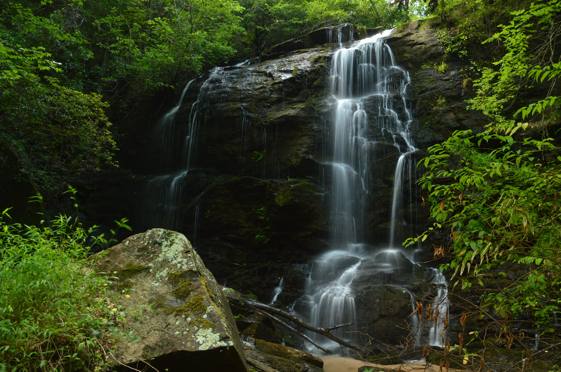
The Lake Russell Wildlife Management Area covers the southeastern extremity of Chattahoochee National Forest. This low-elevation sector of the forest is not known for pleasant hiking trails and spectacular waterfalls/overlooks to the extent that other parts of the forest are. But despite its low elevation, the Lake Russell area is home to a number of waterfalls, most of which have slipped under the radar of hikers and waterfall enthusiasts for years. One of the most spectacular waterfalls is a 50-foot sheer drop - historically referenced to as Tabor Falls - that is located well up an unnamed tributary of the Middle Fork Broad River. Even though a distinct path leads almost to the base of Tabor Falls, the waterfall is largely unknown to the outdoors community, and you're unlikely to see other people in this remote corner of Lake Russell WMA - although there may be exceptions during hunting season. This hike occurred on Saturday, August 12th, 2017. My plan was to find the easiest route from Sellers Road to a waterfall that I discovered on terrain and satellite imagery on an unnamed tributary of the Middle Fork Broad River, learning after my hike that the waterfall's historical name is Tabor Falls. I was surprised to find an unofficial trail in great condition leading almost to the base of the waterfall with only a short off-trail scramble at the end.
*UPDATE 11/12/2023: Logging operations have ended along this hike, but the trail to Tabor Falls has become more difficult to hike. For the first quarter mile from the right turn off FR 89A, the trail has been widened to a logging road and full of small downed tree trunks placed for erosion control. Don't expect a smooth path until the second right turn at the bottom of the hill.
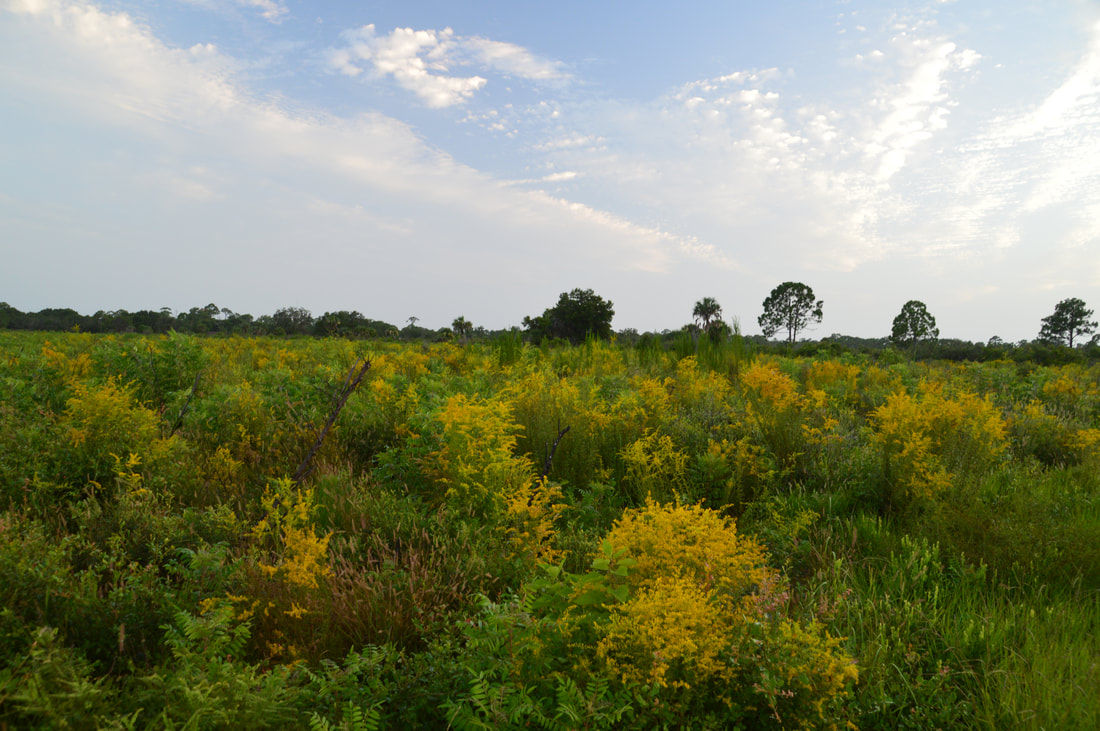
Nestled near the west Florida coastline between Sarasota and Venice, the underrated Oscar Scherer State Park is a haven for folks looking for a peaceful day hike in this part of southwest Florida. The park is known best as the home of the last remaining scrub jay habitat in southwest Florida, but it also has a superb color-coded trail system that introduces hikers to South Creek and its hammocks as well as the scrub and flatwoods nearby. In particular, the diverse Yellow Trail - part of the park's North Trail System - passes through a large range of ecosystems, crossing South Creek twice, passing a beautiful lake known as Big Lake, and travelling through a large section of the scrub. Hikers will even be able to see an old railroad trestle across South Creek. Thanks to its range of scenery and points of interest, the Yellow Trail at Oscar Scherer State Park has quickly turned into one of my favorite hikes in Southwest Florida. This hike occurred on Wednesday, August 2nd, 2017. My plan was to hike the Yellow Loop Trail counter-clockwise with a short detour to the Big Lake observation platform.
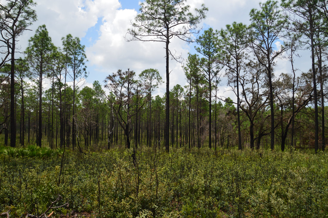
The Citrus Tract of Withlacoochee State Forest is home to some of Central Florida's most rugged terrain. Several major sinkholes and numerous caves are spread throughout the hilly Citrus Tract. The Citrus Trail, one of Florida's longest and most popular backpacking trails, is a 42-mile loop trail that passes near the perimeter of the Citrus Tract. Numerous forest roads crisscross the tract with many different starting points possible. For the convenience of day hikers, three cross-trails intersect the loop, providing shorter hiking opportunities. The southernmost loop of the Citrus Trail - Loop D - accesses one of the area's most unique sights: Dames Cave, a limestone cave with two chambers, a large open one and a smaller closed one. In addition to traversing dozens of rolling sandhills, Loop D of the Citrus Trail also passes through a bizarre rocky landscape in the vicinity of a broad sink known as Lizzie Hart Sink. This hike occurred on Saturday, July 29th, 2017. My plan was to hike Loop D of the Citrus Trail counter-clockwise from the Road 18 crossing. I would take the side trail to Dames Cave along the way.

Emerson Point Preserve is one of several beautiful Manatee County coastline preserves. This preserve on Snead Island is rich with history, as there are several historic Indian mounds scattered throughout the park. The preserve's diverse trail system traverses both the Tampa Bay and Manatee River sides of the island, with several views of both, as well as an observation tower that provides a bird's-eye panorama of the preserve and Tampa Bay, with the Sunshine Skyway Bridge in the distance. Also, the park's primary trail system provides access to the Portavant Temple Mound - the biggest mound of all in the preserve. This hike occurred on Wednesday, July 26th, 2017. My plan was to hike the Portavant Mound Trail from the Ranger Station, making a side trip to the Manatee River view. Then, I would make a clockwise loop with the South Restoration Trail, Terra Ceia Trail, Tower Trail, and North Restoration Trail, making side trips to each of the three Tampa Bay views as well as the observation tower. I would conclude the hike by following a connector back to the Ranger Station.
 A 50-foot waterfall that spouts water from all sides of a jagged sheer cliff, accessible by a steep and tricky yet short path from the Blue Ridge Parkway: that's the matching description for English Falls. Located in Northwest North Carolina not far from the quaint town of Spruce Pine, English Falls possesses charm of a level that few other of the state's waterfalls seem to reach. The setting of the waterfall is magical, due to the lush greenery that peppers the cliffs and boulders at and around the falls. A small drawback of English Falls is that it is on a small unnamed stream, so the flow can be low during parts of the year. Nevertheless, visiting English Falls at the right time will yield one of the most unusual and photogenic waterfalls that you'll ever see. This hike occurred on Tuesday, July 11th, 2017, and a revisit occurred on Wednesday, June 17th, 2020. My plan was to hike out and back to English Falls via the access path from the Blue Ridge Parkway. In 2017, this hike was the tenth and final of ten hikes that I did during a seven-day trip to the mountains of northwest North Carolina.
Update 6/23/20: I have finally revisited English Falls almost three years later. The trail has changed in several ways. English Falls has seen an explosion in visitation over the last few years so the trail is now very trampled down and eroded. As a result, the hike has actually become more difficult. The slope is very slick with few footholds or handholds. Agility and experience with ropes are a must to complete this scramble safely. The trip report has been revised with the most recent directions plus information about Upper English Falls. UPDATE JULY 2023: ROADSIDE PARKING IS NOW PROHIBITED ALL ALONG THE BLUE RIDGE PARKWAY NEAR ENGLISH FALLS. ILLEGALLY-PARKED VEHICLES WILL BE TICKETED. The nearest authorized parking area is over a mile away. The status of the scramble path itself is unclear. Most of the path lies on National Park Service land. It is widely rumored to be closed but no official word has been obtained from the NPS. 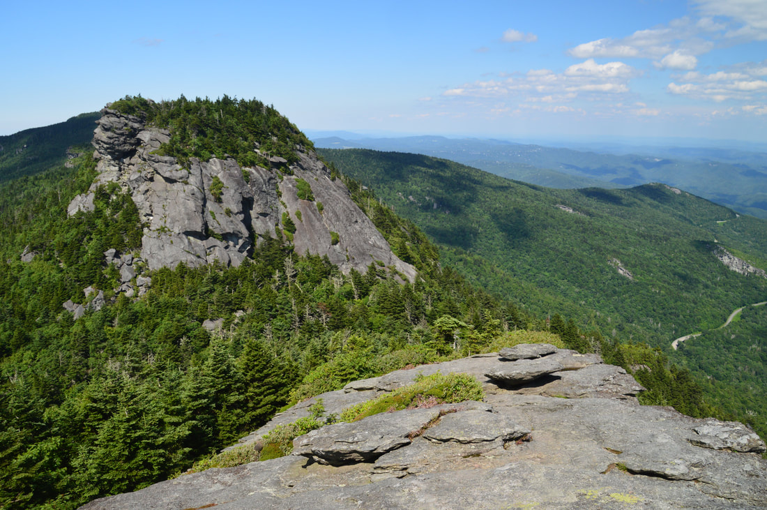
Anyone who lives in the Southeastern United States must have a hike along the crest of Grandfather Mountain on their bucket list. No words or pictures can accurately describe or convey the rugged splendor of the Grandfather Crest. Part of Grandfather Mountain is still operated as a private attraction that does allow public access under a hefty fee and a number of restrictions, but most of the mountain is land owned by the state of North Carolina in the form of Grandfather Mountain State Park. One of the secondary trailheads for Grandfather Mountain is actually off the Blue Ridge Parkway, from which several trails lead to Calloway Peak - the highest point on Grandfather Mountain. From there, the Grandfather Trail makes a very rugged traverse over two other peaks - Attic Window Peak and MacRae Peak - with many technical rock scrambles, cable sections, ladders, and of course, outstanding views. The 360-degree vistas on Attic Window Peak and MacRae Peak are of the type that you would find in Montana or Colorado rather than North Carolina. Eventually, the Grandfather Trail descends into the mountain's private section, reaching Linville Peak (where additional views await) and one of North Carolina's best-known tourist attractions: the Mile-High Swinging Bridge. This hike occurred on Monday, July 10th, 2017. My plan was to hike the Tanawha Trail, Nuwati Trail, Cragway Trail, and Daniel Boone Scout Trail to the summit of Calloway Peak, passing Top Crag View, Flat Rock View, Lynn Cove Viaduct View, and an old plane crash. Then, I would follow the Grandfather Trail over Attic Window Peak and MacRae Peak to Linville Peak and the Swinging Bridge, making side trips to Watauga View and Indian House Cave along the way. My return route would be similar, but I would use the Underwood Trail to bypass MacRae Peak, and I would use only the Daniel Boone Scout Trail instead of the Cragway Trail and Nuwati Trail for a slightly easier descent back to the trailhead from Calloway Peak. This hike was the ninth of ten hikes that I did during a seven-day trip to the mountains of northwest North Carolina.
The 55-foot Laurel Falls is one of Northeast Tennessee's most breathtaking waterfalls. Located just outside of the community of Hampton and off the Appalachian Trail in Pond Mountain Wilderness, access to Laurel Falls is fairly easy, making it a destination that can often be crowded, but the falls and the whole hike is still worthwhile - for there is a lot more to see along this stretch of the AT. Above Laurel Falls, an unofficial side trail makes a steep scramble to the pointy summit of Potato Top, where there are several excellent views of the Laurel Fork Gorge and surrounding wilderness. In addition, the Appalachian Trail between US 321 and Dennis Cove Road passes a lot of pretty creekside scenery and several spectacular cliffs that rise along Laurel Fork Creek. This hike occurred on Sunday, July 9th, 2017. My plan was to hike out and back along the Hampton Blueline Trail and then Appalachian Trail from the trailhead off US 321 near Hampton to the Dennis Cove Trailhead. Along the way, I would take the side trails to Potato Top and Laurel Falls, and on my way back, I would take the high-water bypass route past Laurel Fork Shelter above Laurel Falls for a bit of variation. This hike was the eighth of ten hikes that I did during a seven-day trip to the mountains of northwest North Carolina.
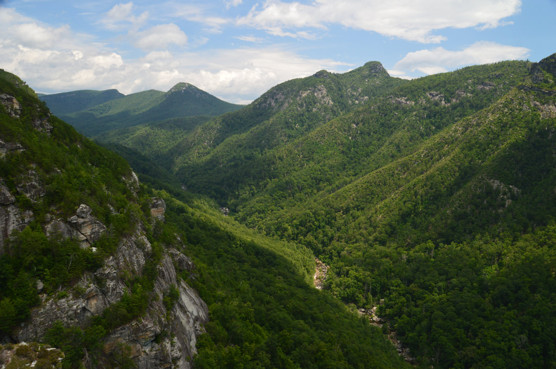
The Linville Gorge Wilderness of Pisgah National Forest, North Carolina's third largest wilderness area, encompasses an area that is one of the most rugged areas in the Southeast: Linville Gorge. Flowing along the bottom of the gorge is the boulder-strewn Linville River, located as much as over 1500 feet below the gorge's rims at its deepest spots. The Linville Gorge Trail runs through nearly the entire length of the gorge, passing countless obstacles as it follows the steep banks of the Linville River for miles. An array of trails and roads runs along the rims of the gorge, and a number of extremely steep paths provide access to the gorge floor, allowing one to hike loops of varying length encompassing both the gorge floor and rim. One of those loops is the Rock Jock Loop: a spectacular yet grueling hike that passes at least six particularly breathtaking vistas and many other smaller views as well as numerous cataracts on the Linville River and one tall waterfall on its tributary. While it is possible to hike the Rock Jock Loop in one day like I did, it will be very tiring, and in order to get the most enjoyable and relaxing experience, turning the Rock Jock Loop into a weekend backpacking trip could be a good idea. This hike occurred on Saturday, July 8th, 2017. My plan was to hike the Rock Jock Loop/Linville Gorge Loop counter-clockwise from the Conley Cove Trailhead. This hike was the seventh of ten hikes that I did during a seven-day trip to the mountains of northwest North Carolina.
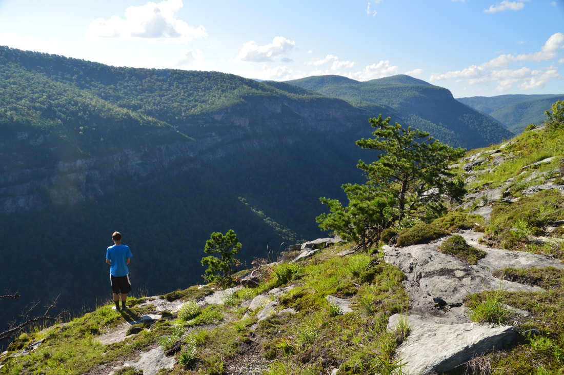
If I had to name the ten best hikes that I have ever done, the hike along the east rim of Linville Gorge to Table Rock and the North Carolina Wall would make the list without question. This section of the Mountains-to-Sea Trail provides access to several jaw-dropping vistas of Linville Gorge as well as its surroundings. North of the Table Rock Picnic Area is the summit of Table Rock, whose lofty peak is surrounded by cliffs hundreds of feet high and whose elongated rocky summit is home to a series of grand vistas that encompass a 360-degree view. Meanwhile, to the south, the MST first passes through a place called The Chimneys, a series of wild and jagged rock outcrops of all shapes and sizes, where the knife-edge ridge with 360-degree views forms a boundary between the rolling hills of the North Carolina Piedmont and the ruggedness of Linville Gorge. Then, if all of that wasn't enough, a pair of side trails lead to the North Carolina Wall. Rising hundreds of feet high, the North Carolina Wall is an incredible line of cliffs with continuous views over a half-mile long along the east rim of the gorge. This hike occurred on Friday, July 7th, 2017. My plan was to hike the Mountains-to-Sea Trail and Table Rock Trail from the Table Rock Picnic Area to the summit of Table Rock. On my way back, I would take a side trail to an area of cliffs known as the Devil's Cellar. Then, I would follow the Mountains-to-Sea Trail in the other direction to and through The Chimneys, before taking a side trail down to an area on the rim of the gorge known as The Amphitheater. Finally, I would follow another faint trail along the top of the NC Wall back to the MST, before retracing my steps back to the picnic area. This hike was the sixth of ten hikes that I did during a seven-day trip to the mountains of northwest North Carolina.
|
About MeMark Oleg Ozboyd Dear readers: I have invested a tremendous amount of time and effort in this website and the Georgia Waterfalls Database the past five years. All of the work that has gone in keeping these websites updated with my latest trip reports has almost been like a full-time job. This has not allowed me to pick up a paid job to save up money for college, and therefore, I I've had to take out loans. If you find the information on this website interesting, helpful, or time-saving, you can say "thanks" and help me out by clicking the button above and making a contribution. I will be very grateful for any amount of support you give, as all of it will apply toward my college tuition. Thank you!

Coming in 2022-2023?
Other Hiking WebsitesMiles HikedYear 1: 540.0 Miles
Year 2: 552.3 Miles Year 3: 518.4 Miles Year 4: 482.4 Miles Year 5: 259.9 Miles Archives
March 2021
Categories
All
|
 RSS Feed