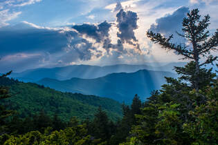
The Shining Rock Wilderness is Southwest North Carolina's high country - an area crowned by numerous 6000-foot peaks with stunning mountain views. Deep in the Little East Fork Pigeon River valley is the Daniel Boone Scout Camp, a convenient entry point to the Shining Rock Wilderness near its northern end. Two trails, Little East Fork Trail and Art Loeb Trail, leave the camp and make for a long, scenic loop visiting a number of the wilderness's highlights in its north sector. Climbing steeply out of the valley, the Art Loeb Trail's first stop is Deep Gap, where a 1.5-mile side trail leads to several panoramic overlooks atop Cold Mountain. The Art Loeb then embarks on an exciting journey through The Narrows, where a series of ups and downs along a knife-edge ridge take you past two great views and numerous rock outcrops. After a gradual climb up Stairs Mountain through gorgeous mossy spruce-fir forest, the Art Loeb approaches the wilderness's center point: Shining Rock. Featuring its own panoramic views, Shining Rock is a huge outcropping of brilliant white quartz amidst a sea of evergreen. Backpackers will find Shining Rock to be a great sunset-viewing location. Your exit route from the wilderness is the Little East Fork Trail, which descends an old roadbed along the countless pleasant cascades of Little East Fork's scenic run. This hike occurred on Saturday, June 9th, 2018. My plan was to hike the Scout Camp Loop clockwise, first hiking the Art Loeb Trail and then Little East Fork Trail. Along the way, I took side trips to Cold Mountain and Shining Rock.
2 Comments
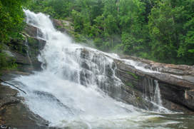
The Thompson River is one of several great rivers in the Jocassee Gorges region on the south side of Lake Toxaway. Although the Thompson River isn't as well-known as the nearby Whitewater River (due to Whitewater Falls) or Horsepasture River (due to Rainbow Falls), the Thompson features a collection of gorgeous waterfalls, including a 200-foot monster called Big Falls. Big Falls on Thompson River is an awesome, massive waterfall that crashes down through an enormous open area full of cliffs and borders. This spectacular waterfall should be on every experienced waterfaller's must-see list. Much of the hike to Big Falls follow an unofficial moderate trail along an old logging road that meanders near the Thompson River. However, the final section of the Big Falls hike is an extreme descent into the gorge, including several short rock scrambles. Along the Big Falls hike, you'll pass side trails to three other beautiful waterfalls that are all unique in their own ways and are worth seeing. This hike occurred on Saturday, May 26th, 2018. My plan was to hike out and back to Big Falls from Brewer Road. On my way in, I would make a side trip to Simon Falls. On my return trip, I would make side trips to Rich Falls and High Falls. Unfortunately, a series of heavy thunderstorms messed up my plans slightly, but it was still a great day.
Chattooga Wild and Scenic River: Long Creek Falls and Homer's Falls, Westminster, South Carolina7/5/2018 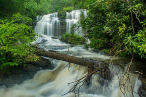
Nearly every tributary of the Wild and Scenic Chattooga River has waterfalls of some sort. 40-foot Long Creek Falls is a particularly spectacular drop only 100 feet above the Chattooga River. Long Creek Falls is accessed by a lesser-known yet easy unofficial trail from Turkey Ridge Road (FS 755), about 1.7 miles long. The great swimming hole and large flat rocks around Long Creek Falls make it an excellent summertime destination. The Long Creek Falls Trail additionally passes a steep side path to a seldom-visited cascading waterfall on Pinckney Branch called Homer's Falls. Flowing only in wet weather, Homer's Falls flows 20 feet through an incredibly lush and mossy rock grotto before emptying into the Chattooga River. Hikers who go to Long Creek Falls even have the option of making a side trip to the top of Raven Rock Cliff, a 100-foot cliff that towers over the Chattooga River and features great gorge views. This hike occurred on Saturday, May 19th, 2018. My plan was to hike out and back to Long Creek Falls from the end of FS 755, making the side trip to Homer's Falls along the way.
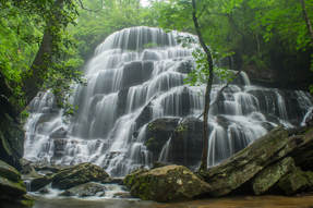
Yellow Branch Falls is an absolutely phenomenal waterfall in Oconee County, South Carolina (although it needs a lot of water to look its best). Over 50 feet high, Yellow Branch Falls features a stunning clamshell-shaped drop that spreads out in countless mini-trickles across a jagged rock face. From the Yellow Branch Recreation Area off Highway 28, an easy-to-moderate hiking trail leads 1.65 miles down the Yellow Branch valley past several smaller cascades to the falls. In addition, an unnamed tributary of Yellow Branch features a 35-foot cascading waterfall called Lohr's Falls. Lohr's Falls is only for experienced waterfallers, as there's no trail whatsoever to it. This hike occurred on Saturday, May 19th, 2018. My plan was to hike the trail out and back to Yellow Branch Falls. Along the way back, I would bushwhack to Lohr's Falls.
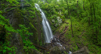
Lee Falls is often cited as one of Upstate South Carolina's top ten most beautiful waterfalls. Over 80 feet high, Lee Falls is an absolutely stunning free-falling drop in a 'tropical paradise' setting, surrounded by lush greenery on all sides. Although the moderate trail to Lee Falls isn't official, it's easily followed for 1.5 miles all the way to the falls. Along the way, you'll pass through several overgrown wildlife clearings and make six creek crossings as you scramble up the Tamassee Creek valley to Lee Falls. The best time of year to visit Lee Falls is during late spring after a good rain, when all the lush green growth around Lee Falls is particularly eye-popping and beautiful. Just be sure to go when the water levels are high. This hike occurred on Saturday, May 19th, 2018. My plan was to hike out and back to Lee Falls.
|
About MeMark Oleg Ozboyd Dear readers: I have invested a tremendous amount of time and effort in this website and the Georgia Waterfalls Database the past five years. All of the work that has gone in keeping these websites updated with my latest trip reports has almost been like a full-time job. This has not allowed me to pick up a paid job to save up money for college, and therefore, I I've had to take out loans. If you find the information on this website interesting, helpful, or time-saving, you can say "thanks" and help me out by clicking the button above and making a contribution. I will be very grateful for any amount of support you give, as all of it will apply toward my college tuition. Thank you!
Coming in 2022-2023?
Other Hiking WebsitesMiles HikedYear 1: 540.0 Miles
Year 2: 552.3 Miles Year 3: 518.4 Miles Year 4: 482.4 Miles Year 5: 259.9 Miles Archives
March 2021
Categories
All
|

 RSS Feed