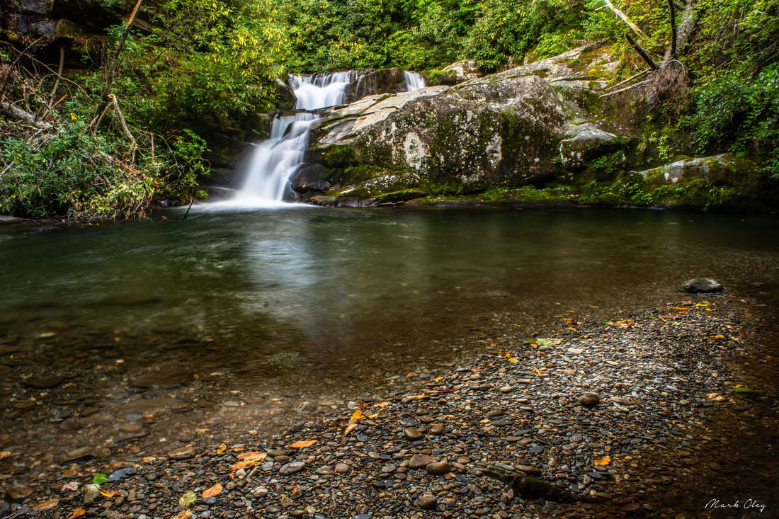
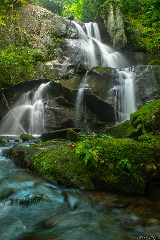
Imagine a large mountain waterway winding its way through a wilderness for nearly a dozen miles with zero road access. Picture a rugged, little-traveled pathway following this waterway, crisscrossing the creek many times through deep, slick fords, circumnavigating countless blowdowns and rock scrambles. There, you've discovered the Slickrock Creek Trail! This is the best creek trail I've ever walked in the Southern Appalachian Mountains, and I'm not even exaggerating. Nowhere else have I found a combination of such remote beauty and rugged wilderness trail, which never follows any of the logging roads customary to most North Carolina waterways. As if you needed more incentive to tackle this hike, the Slickrock Creek Trail features two secluded waterfalls - Wildcat Falls and Lower Falls - with swimming holes that couldn't be any more refreshing after a long summer day in the backcountry. This hike occurred on Saturday, September 15th, 2018. My plan was to day hike a lengthy loop through the heart of the Joyce Kilmer-Slickrock Creek Wilderness backcountry. I would start off along the Slickrock Creek Trail at Cheoah Dam along US 129, but before long, I would take the Ike Branch Trail. At Yellowhammer Gap, I would pick up the Yellowhammer Gap Trail, followed by the Nichols Cove Trail and Windy Gap Trail. The Windy Gap Trail would finally bring me to Slickrock Creek, from where I'd spend the rest of the day tracing the Slickrock Creek Trail back to US 129.
0 Comments
Nestled between the Little Tennessee River and the Cherohala Skyway, the 16,226-acre Citico Creek Wilderness features some of East Tennessee's most remote hiking trails. The primary focus points of the wilderness are its two major waterways: the North and South Forks of Citico Creek. Seldom-traveled trails follow both streams, crisscrossing them many times along the way, and providing numerous views of the creeks' many scenic cascades and pristine banks. Even better, a short scramble off the North Fork Trail is the spectacular Old Goat Falls, crashing 40 feet through a cleft amidst ferny cliffs. This hike, an ambitious loop along both forks of Citico Creek all the way to their headwaters, is among the best creek hikes in Cherokee National Forest. This hike occurred on Saturday, September 1st, 2018. My plan was to initially follow the South Fork Trail from Citico Creek Road to the North Fork Trail junction. There, I would pick up the North Fork Trail and climb it to Cherry Log Gap, scrambling down to Old Goat Falls along the way. I would then follow the Benton MacKaye Trail from Cherry Log Gap to Cold Spring Gap, from where I would take the South Fork Trail back to Citico Creek Road.
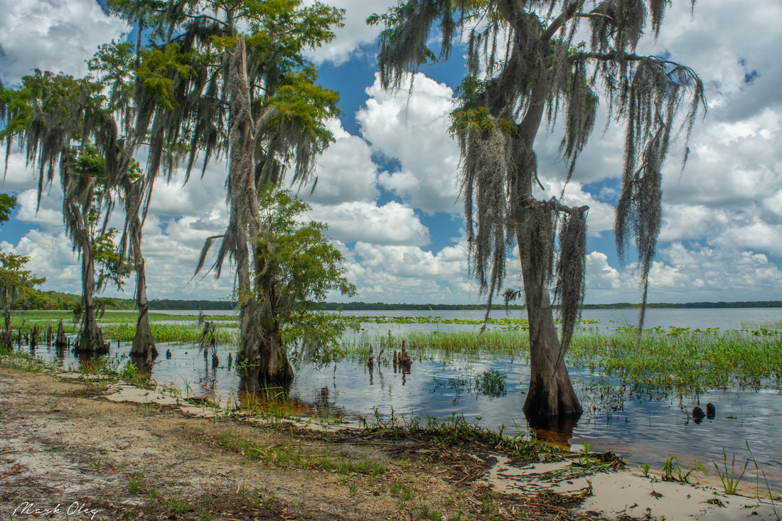
Hiking in Florida typically means looking for certain highlights such as interesting woods, creeks, lakes, or historic sites. But what if you could fit all of that into one hike? That's something the north loop at the Arbuckle Tract of Lake Wales Ridge State Forest manages to accomplish. In under just 14 miles, this trail visits the shorelines of Lake Arbuckle and Lake Godwin, affords numerous views of both Reedy Creek and Livingston Creek, and passes through a variety of different woods and ecosystems that range from unique pine flatwoods full of cutthroat seep grass to open, sandy scrub areas. This hike is easily among the most scenic I've done in Central Florida. Not often do you find such a mix of beautiful scenery on a single trail in Florida, keeping your interest piqued and letting the miles roll by faster. This hike occurred on Saturday, August 4th, 2018. My plan was to hike the North Loop in the Arbuckle Tract counter-clockwise from McLean Cabin Trailhead.

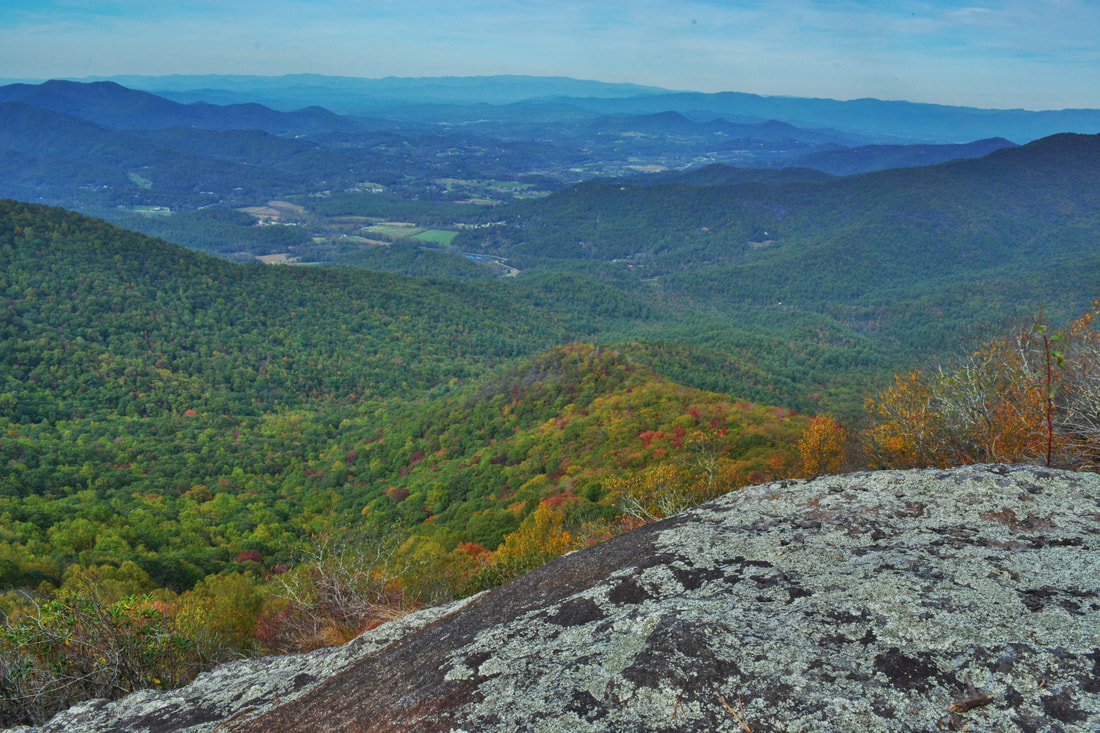
The Shining Rock Wilderness is Southwest North Carolina's high country - an area crowned by numerous 6000-foot peaks with stunning mountain views. Deep in the Little East Fork Pigeon River valley is the Daniel Boone Scout Camp, a convenient entry point to the Shining Rock Wilderness near its northern end. Two trails, Little East Fork Trail and Art Loeb Trail, leave the camp and make for a long, scenic loop visiting a number of the wilderness's highlights in its north sector. Climbing steeply out of the valley, the Art Loeb Trail's first stop is Deep Gap, where a 1.5-mile side trail leads to several panoramic overlooks atop Cold Mountain. The Art Loeb then embarks on an exciting journey through The Narrows, where a series of ups and downs along a knife-edge ridge take you past two great views and numerous rock outcrops. After a gradual climb up Stairs Mountain through gorgeous mossy spruce-fir forest, the Art Loeb approaches the wilderness's center point: Shining Rock. Featuring its own panoramic views, Shining Rock is a huge outcropping of brilliant white quartz amidst a sea of evergreen. Backpackers will find Shining Rock to be a great sunset-viewing location. Your exit route from the wilderness is the Little East Fork Trail, which descends an old roadbed along the countless pleasant cascades of Little East Fork's scenic run. This hike occurred on Saturday, June 9th, 2018. My plan was to hike the Scout Camp Loop clockwise, first hiking the Art Loeb Trail and then Little East Fork Trail. Along the way, I took side trips to Cold Mountain and Shining Rock.
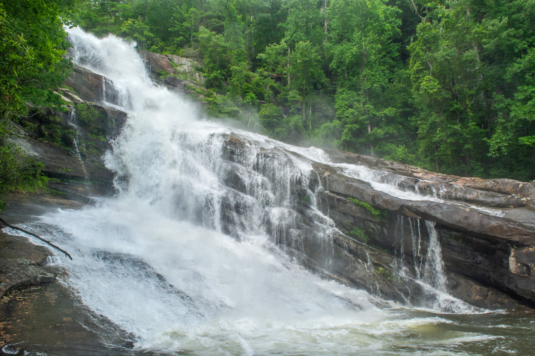
The Thompson River is one of several great rivers in the Jocassee Gorges region on the south side of Lake Toxaway. Although the Thompson River isn't as well-known as the nearby Whitewater River (due to Whitewater Falls) or Horsepasture River (due to Rainbow Falls), the Thompson features a collection of gorgeous waterfalls, including a 200-foot monster called Big Falls. Big Falls on Thompson River is an awesome, massive waterfall that crashes down through an enormous open area full of cliffs and borders. This spectacular waterfall should be on every experienced waterfaller's must-see list. Much of the hike to Big Falls follow an unofficial moderate trail along an old logging road that meanders near the Thompson River. However, the final section of the Big Falls hike is an extreme descent into the gorge, including several short rock scrambles. Along the Big Falls hike, you'll pass side trails to three other beautiful waterfalls that are all unique in their own ways and are worth seeing. This hike occurred on Saturday, May 26th, 2018. My plan was to hike out and back to Big Falls from Brewer Road. On my way in, I would make a side trip to Simon Falls. On my return trip, I would make side trips to Rich Falls and High Falls. Unfortunately, a series of heavy thunderstorms messed up my plans slightly, but it was still a great day.
Just off NC 281 is a lesser-known entrance to the backcountry of Panthertown Valley: the West Fork Way trailhead. The unofficial West Fork Way ascends through the West Fork French Broad River watershed for several miles, passing the extremely steep access trail to three spectacular waterfalls: Rhapsodie Falls, Dismal Falls, and Lower Dismal Falls. West Fork Way then connects to another unofficial trail on the fringes of Panthertown Valley called the Shelton-Pisgah Trail, which follows a seldom-hiked pathway along the ridge of Shelton-Pisgah Mountain to Cold Mountain. A cliff on the west side of Cold Mountain, nicknamed the High Bethel View features an outstanding vista of Panthertown Valley spread out to the west - arguably the best of the valley's five views. This hike occurred on Saturday, May 12th, 2018. My plan was to hike West Fork Way and Shelton-Pisgah Trail out and back to Cold Mountain. Along the way, I would take the side trails to Rhapsodie Falls, Dismal Falls, and Lower Dismal Falls. I would also stop by two other small falls - Aunt Sally's Falls and Lower Rhapsodie Falls.
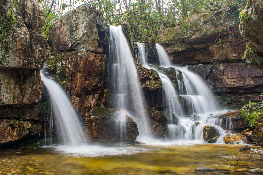
Streams flowing off the north slopes of Unaka Mountain feature many of Northeast Tennessee's finest waterfalls. Particularly notable is a stream called Dick Creek, which features four stunning waterfalls in the Unaka Mountain Wilderness, including a unique 25-foot quadruple-flow falls and a spectacular 60-foot part-free-falling waterfall. All four waterfalls can be accessed out of Rock Creek Recreation Area via the Rattlesnake Ridge Trail, Dick Creek Trail/Road, and an unofficial pathway along Dick Creek. Additionally, a more popular waterfall - Rock Creek Falls - can be included on this hike, as it's also accessed out of Rock Creek Recreation Area along the Rock Creek Falls Trail, a very scenic trail with numerous stream views and even a bonus waterfall. This hike occurred on Thursday, April 26th, 2018. My plan was to hike out and back along the Rattlesnake Ridge Trail and Dick Creek Trail/Road to the waterfalls on Dick Creek. I would then return to the Rock Creek Recreation Area and hike the Rock Creek Trail out and back to Rock Creek Falls. This hike was the first of six hikes that I did during a four-day trip to the mountains of northeast Tennessee and northwest North Carolina.
Pisgah Civitan Park: Pisgah Gorge Trail and Little Bryant Creek Waterfalls, Pisgah, Alabama5/9/2018 
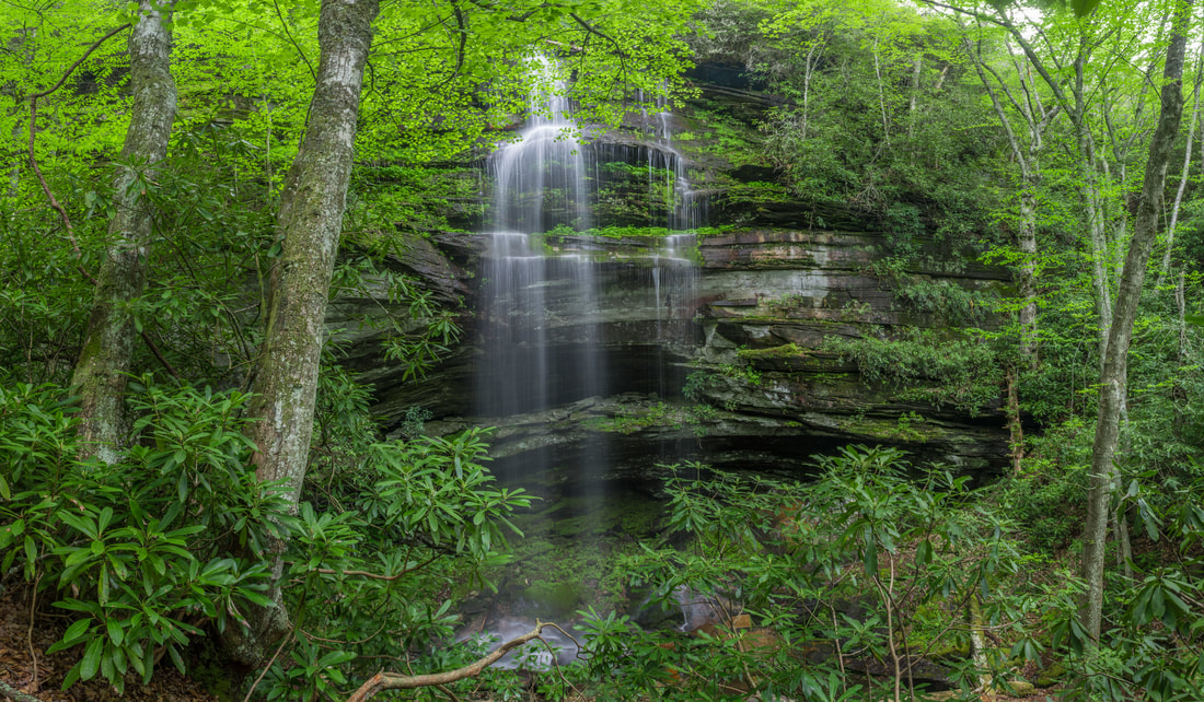
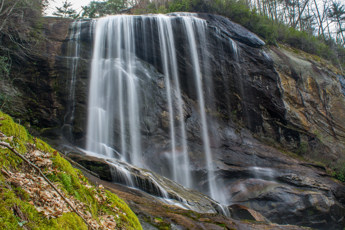
Inside the city limits of the quaint town of Pisgah in northeast Alabama is one of the area's most under-appreciated pieces of public land: the Pisgah Civitan Park. This small community park protects a section of the course of Little Bryant Creek through Pisgah Gorge that features three notable waterfalls - two of which are significant - and an extraordinary natural bridge. An easy trail follows the rim of the gorge, accessing several clifftop perches with sweeping birds-eye views of the gorge and its waterfalls. More adventurous hikers will find a faint, rugged pathway that drops into the gorge, accessing the base of Middle Little Bryant Creek Falls and the natural bridge. Pisgah Gorge features a sampling of some of Northeast Alabama's finest natural scenery and must not be missed! This hike occurred on Saturday, March 17th, 2018. My plan was to first hike the rim trail out and back to views of Upper Little Bryant Creek Falls, Middle Little Bryant Creek Falls, and the Pisgah Gorge downstream. I would then descend the trail into the gorge to get up-close and personal with the middle falls and the arch. In addition, I would check out a side trail leading to an old mill site at the top of the upper falls.
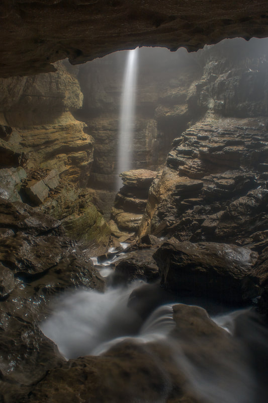
Have you ever wanted to see both a waterfall and a cave on one hike? Then Stephens Gap Callahan Cave Preserve is the place for you. Not only do you get to see a waterfall and a wild cave here, but they are both in the same place! The gloomy cavernous space of Stephens Gap Cave features an incredible waterfall that shoots out of an opening in the cave and free-falls over 100 feet into the pit underneath. What's more: you don't need any caving experience at all to get into the Stephens Gap Cave's primary chamber and to view the waterfall. As long as you're capable of scrambling steeply down a boulder field into the cave and don't mind getting dirty, you can easily tour this stunning natural feature. The short hike to the cave is pretty in its own right, especially in spring, when a mosaic of new, bright green ferns is seen among the area's boulder fields and rock outcrops. Access to Stephens Gap Cave is exclusively by a permit system. Only 25 people are allowed to visit the cave on any given day, so it's best to register for your free online permit from the Southeastern Cave Conservancy in advance to ensure your access to the cave. For the best experience, visit the cave after rainfall or during a wetter period - that's when the falls is the most impressive. This hike occurred on Saturday, March 17th, 2018. My plan was to hike out and back to Stephens Gap Cave via the access trail from County Road 30.
Adjacent to the popular Panthertown Valley hiking area lies a much-lesser-visited valley: the Flat Creek watershed. This remote area is home to two very scenic waterfalls on Flat Creek. The massive Flat Creek Falls is among the most spectacular and stunning waterfalls in the Southeast. Dropping as much as 200 feet in a series of powerful cascades, slides, and a huge free-fall, Flat Creek Falls evokes a sense of amazement among anyone who finds their way to its base. Flat Creek features a much smaller but equally notable waterfall as well: Nellie's Falls. Located a couple of miles upstream, Nellie's Falls is a very picturesque double-drop waterfall. The lush, tropical-like setting of Nellie's Falls - the long moss-covered rock slabs near the base of the falls, in particular - help to make it a very scenic destination. Both waterfalls can be seen in the same hike, which utilizes mostly old roadbeds and unmaintained paths. Although the majority of the hike to both falls is fairly easy, getting to the base of Flat Creek Falls involves a steep off-trail descent. This hike occurred on Saturday, April 7th, 2018. My plan was to hike out and back from the end of Rock Bridge Road first to Nellie's and then to Flat Creek Falls.
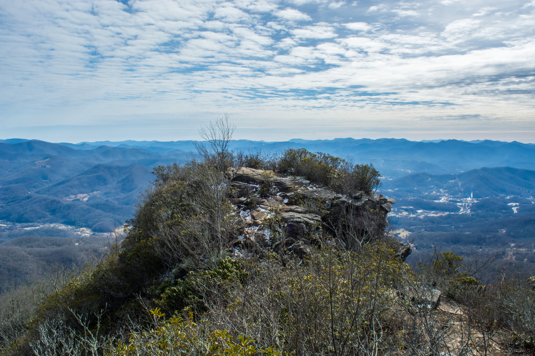
The Pinnacle, a famous rock outcrop that stands sentinel over the town of Sylva, is known well throughout the hiking community for its breathtaking views. The Pinnacle and Blackrock Mountain - a nearby peak with another stunning view - are part of the Plott Balsam Mountains, which are among the highest mountains in the Southeast. The area around The Pinnacle and Blackrock used to be a watershed that provided all of Sylva's drinking water and was strictly off-limits. However, as Sylva became in need of a better water supply, the watershed was transformed into Pinnacle Park. Later, the Blackrock Ridge Tract - an area of previously-private land that included Blackrock Mountain - was purchased, and today, a well-used network of trails connects The Pinnacle and Blackrock to the park's entrance off Fisher Creek Road and to the Blue Ridge Parkway. This hike occurred on Saturday, February 3rd, 2018. My plan was to hike the West Fork/East Fork Loop clockwise. Along the way, I would make side trips to The Pinnacle and Blackrock, and I would also bushwhack to Gina Falls and Fisher Falls.
Caesars Head State Park/Mountain Bridge Wilderness: Naturaland Trust Loop, Cleveland, South Carolina1/25/2018 
The west half of the Mountain Bridge Wilderness is encompassed by Caesars Head State Park, named for a prominent rock outcrop with striking views of the South Carolina Upstate. One of the area's main highlights is Raven Cliff Falls, a majestic waterfall on Matthews Creek that is cited to be 420 feet high. Among the wilderness's most scenic trails, the Naturaland Trust Trail provides direct access into the Matthew Creek gorge, passing views of Raven Cliff Falls after crossing an elegant suspension bridge at the waterfall's top. Several other trails in the park can be used to create the 12-mile loop Naturaland Trust Loop, which is not only among South Carolina's top hikes but also a very strenuous one. An added bonus for hiking the full loop, however, is optional access to two more gorgeous waterfalls on the property of Asbury Hills Camp: Moonshine Falls and Confusion Falls. This hike occurred on Saturday, January 20th, 2018. My plan was to hike the Naturaland Trust Loop clockwise from the Raven Cliff Falls parking area, although I came away with the feeling that hiking the loop counter-clockwise is better.
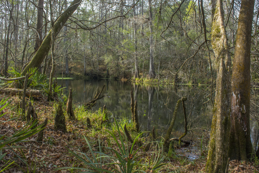
Most hikers of the Tallahassee area have heard of or even been to Leon Sinks. How many have heard of Wakulla River Sinks though? Along with adjacent Apalachicola National Forest, the River Sinks Tract - a lesser-known parcel of Wakulla Springs State Park - holds nearly two dozen water-filled sinkholes. The sinks serve as a portal to the mysterious underground water-filled cave system that eventually connects to the Wakulla River to the southeast. An official trail called the Wakulla River Sinks Trail passes by several small sinks, including the photogenic Clearcut Sink. If one extends their hike along the unofficial pathway that splits off and leads to a series of bigger sinks, including Promise Sink and Upper River Sink, they are bound to be astounded! This hike occurred on Saturday, January 6th, 2018. My plan was to hike the official Wakulla River Sinks Trail clockwise. Along the way, I would make out-and-back side trips to Clearcut Sink and along an unofficial trail to a series of sinks to the south.
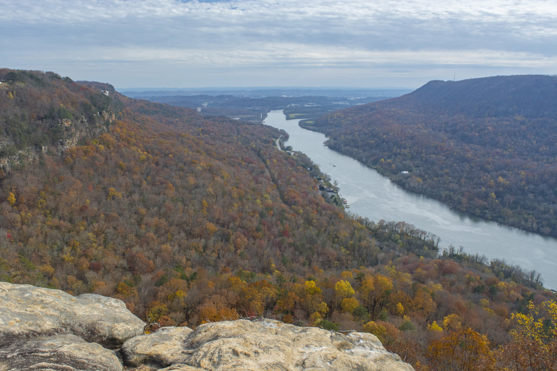
The Cumberland Trail, a work in progress that will be a 300-mile trail when completed, has its southern terminus at Signal Point in the Chattanooga metro area. One of the Cumberland Trail's most spectacular sections is its very first one as it traces the rim of the Tennessee River Gorge, visiting outstanding views at Signal Point and Edwards Point as well as a unique geological formation known as Mushroom Rock at the edge of the Suck Creek Gorge. Beside the Cumberland Trail, several lesser-used trails give hikers the option to turn a hike to Edwards Point into a full-day loop with additional sights. Most notable is a spectacular half-mile section of the Orange Trail as it follows a remote and rugged bluff line in the Middle Creek Gorge. This hike occurred on Saturday, November 25th, 2017. My plan was to hike a loop from Signal Point that would follow the Cumberland Trail past Edwards Point all the way to Mushroom Rock, from where I would follow the Mushroom Rock Trail, Blue Trail, Orange Trail, and Bee Branch Trail back to Signal Mountain. After coming out at Ohio Avenue, I would conclude the hike with a short roadwalk through the town of Signal Mountain to Signal Point.
The Arkaquah Trail has always been one of Georgia's most famous trails thanks to its difficulty and its approach to the tallest peak in the state. Of the three different trails that summit Brasstown Bald, the Arkaquah Trail is undoubtedly the most scenic. In fact, whereas the crowded summit of Brasstown Bald with its large observation tower may not be alluring to wilderness hikers, three other vistas can be found near the Arkaquah Trail. The view from Chimneytop Mountain in particular is arguably one of the state's most jaw-dropping views with its 180-degree panorama! Even more remarkable is that this view remains largely unknown to the hiking community despite its proximity to the Arkaquah Trail. With the two other beautiful overlooks plus the Brasstown Bald summit accessible via the trail, the Arkaquah Trail is one of the most scenic hikes in North Georgia. This hike occurred on Saturday, October 21st, 2017. My plan was to hike out and back along the Arkaquah Trail to the summit of Brasstown Bald, making side trips to the three views along the way.
|
About MeMark Oleg Ozboyd Dear readers: I have invested a tremendous amount of time and effort in this website and the Georgia Waterfalls Database the past five years. All of the work that has gone in keeping these websites updated with my latest trip reports has almost been like a full-time job. This has not allowed me to pick up a paid job to save up money for college, and therefore, I I've had to take out loans. If you find the information on this website interesting, helpful, or time-saving, you can say "thanks" and help me out by clicking the button above and making a contribution. I will be very grateful for any amount of support you give, as all of it will apply toward my college tuition. Thank you!

Coming in 2022-2023?
Other Hiking WebsitesMiles HikedYear 1: 540.0 Miles
Year 2: 552.3 Miles Year 3: 518.4 Miles Year 4: 482.4 Miles Year 5: 259.9 Miles Archives
March 2021
Categories
All
|
 RSS Feed