HIKING THE APPALACHIANS AND BEYOND
  • Home
  • Trail Reports
    • Best Hikes
    • Hikes with Scenic Views
    • Hikes with Water Features
    • Alabama
    • Georgia
    • Florida
    • North Carolina
    • South Carolina
    • Tennessee
    • Vermont
    • Virginia
  • Map
  • Hike List
  • Testimonials
  • Resources
  • Contact Us
  • Southeast Nature Society
    • Our Team
  • Georgia Waterfalls Database

Chattahoochee National Forest: Rogers Branch Falls, Helen, Georgia

7/20/2017

4 Comments

 
Picture
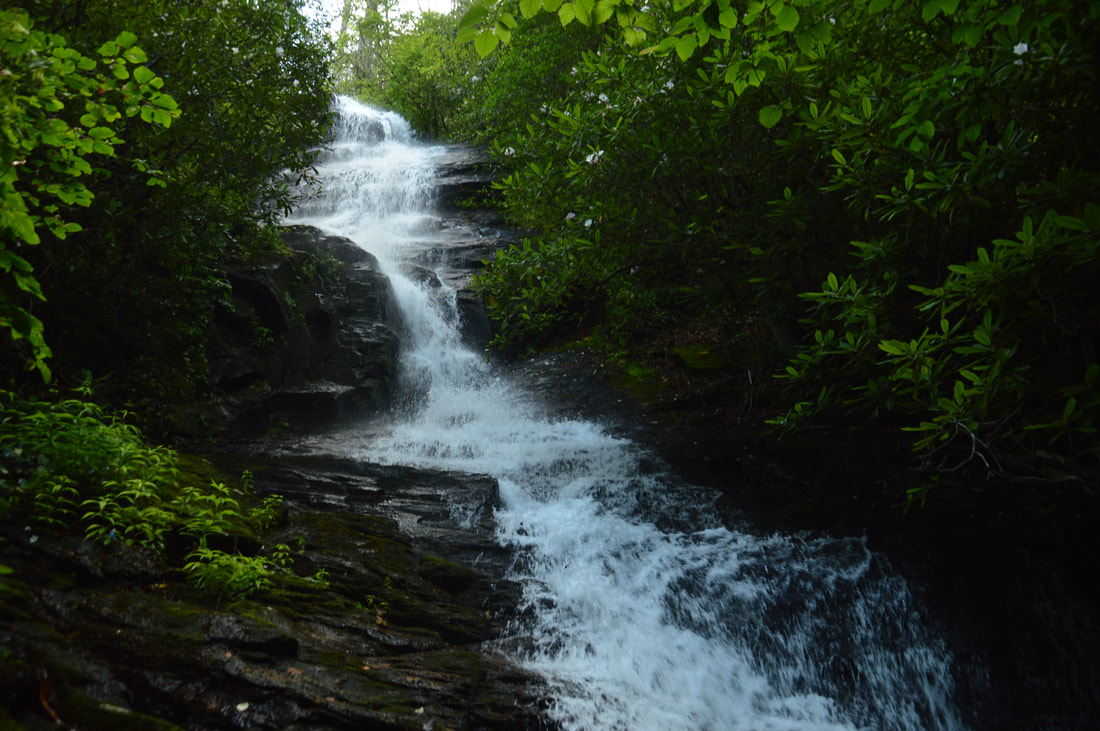
High Shoals Creek is home to two of Georgia's most popular waterfalls: High Shoals Falls and Blue Hole Falls. Very few people who hike to those waterfalls know that the same watershed is home to a remote waterfall no less impressive. Rogers Branch Falls is a tiered 80-foot waterfall on a tributary of High Shoals Creek, with additional small waterfalls above and below the main drop. Even though local residents are aware of the waterfall as evidenced by the well-used path to it, it is not publicized well at all and clearly off the radar for most hikers and waterfall hunters. The routes to the base of Rogers Branch Falls are not quite for everyone due to their steepness, but those who reach the viewing area at the base will be rewarded by a breathtaking sight. This hike occurred on Saturday, July 1st, 2017. My plan was to hike out and back to the base of Rogers Branch Falls from a popular camping area off Indian Grave Gap Road. 


Read More
4 Comments

Chattahoochee National Forest: Lower & Upper Chinquapin Falls and Hickory Knob Falls, Helen, Georgia

7/12/2017

3 Comments

 
Picture
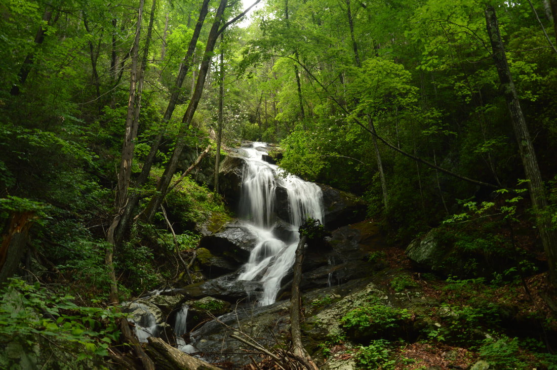
Chinquapin Branch is one of the streams that drain the Tray Mountain area near Helen. Beginning high in the Tray Mountain Wilderness, Chinquapin Branch passes over a tall cliff, crosses Tray Mountain Road, and then forms several more waterfalls. Cascading 200 feet partially out of sight, Lower Chinquapin Falls is the biggest waterfall of them all. Seeing the lower and middle waterfalls on Chinquapin Branch necessitates significant scrambling on an unmaintained trail, but intrepid hikers who hike the entire route will be rewarded with two pristine waterfalls on Chinquapin Branch and a third one on a tributary. This hike occurred on Saturday, June 24th, 2017. My plan was to follow an abandoned trail along Chinquapin Branch to Lower and Upper Chinquapin Falls, although I would only be able to view part of the Lower Falls. Along the way, I would make a side trip to Hickory Knob Falls on an unnamed tributary of Chinquapin Branch. Rather than returning the same way, I decided to hike off-trail to Tray Mountain Road from Upper Chinquapin Falls and then return along the road. 


Read More
3 Comments

Chattahoochee National Forest: Lost House Branch Falls, Helen, Georgia

6/9/2017

1 Comment

 
Picture
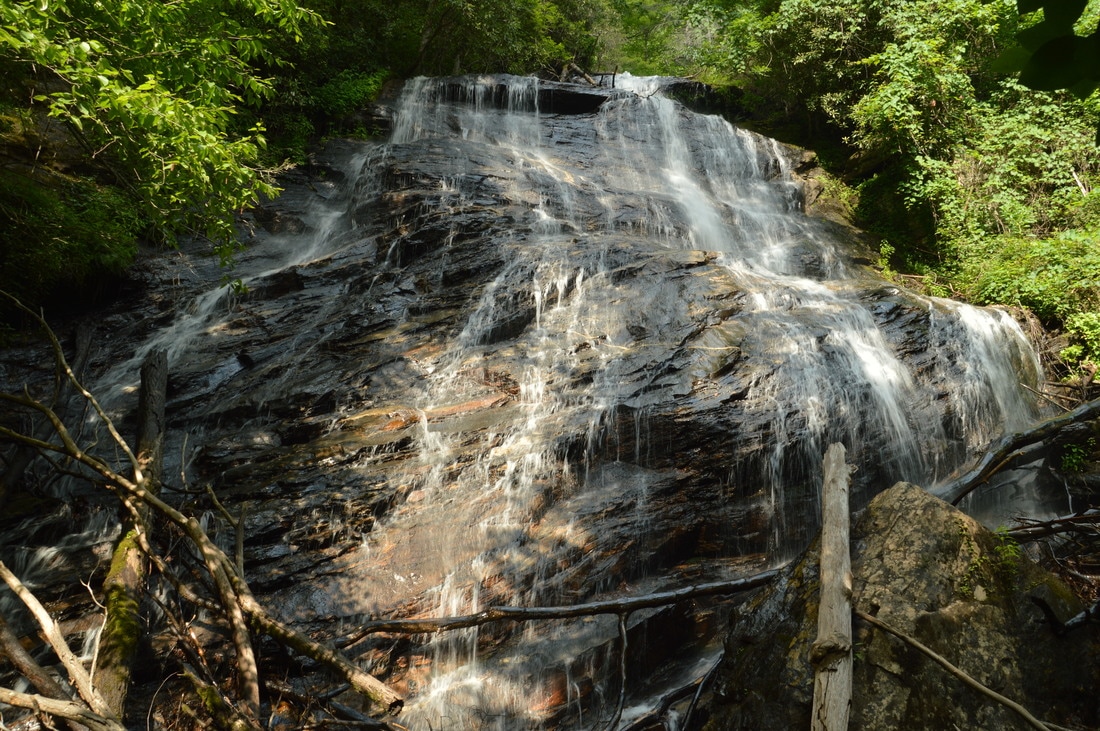
Lost House Branch is a pleasant gurgling stream that flows inconspicuously through a culvert under Highway 75 between Helen and Unicoi Gap. Few folks who drive across Lost House Branch suspect that there is a massive 100-foot waterfall less than a half-mile upstream. This is evidenced by the difficulty of the hike to Lost House Branch Falls, which involves walking in the creek itself, wading through knee-deep summer brush, and scrambling over or under numerous fallen trees. Not enough people have hiked to Lost House Branch Falls yet for a path to become established, but for the most persistent adventurers, the reward is a majestic waterfall. Lost House Branch splits into dozens of thin trickles as it slides down a huge rock face at the waterfall, although it is important to keep in mind that Lost House Branch needs a lot of water to look its best. This hike occurred on Saturday, June 3rd, 2017. My plan was to hike to Lost House Branch Falls out and back from Highway 75, initially following the south side of the stream to avoid trespassing on private property. 


Read More
1 Comment

Chattahoochee National Forest: Waterfalls of Spoilcane Creek, Helen, Georgia

6/6/2017

2 Comments

 
Picture
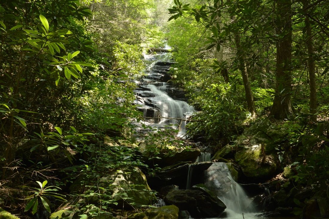
Motorists who drive north along Highway 75 from Helen may notice a deep valley/gorge on the left (west) side of the roadway, but most of them will not stop to muse about what's down there. When the more intrepid hiker takes a glance at the topographic map for the area around Spoilcane Creek and Highway 75, however, he will notice that there is significant waterfall potential in the Spoilcane Creek gorge. In fact, Spoilcane Creek has two major waterfalls - one of which is approximately 190 feet high! Additionally, folks who venture into the Spoilcane Creek gorge will find a bonus waterfall on an unnamed tributary to Spoilcane Creek. Access to the surprisingly rarely-visited Spoilcane Creek waterfalls is not very difficult thanks to a distinct path that follows the historical route of the Unicoi Turnpike and provides a close approach to all three waterfalls. This hike occurred on Saturday, June 3rd, 2017. My plan was to hike out and back to the Middle Falls on Spoilcane Creek via an unmarked trail from a pullout on the west side of Highway 75 just south of Unicoi Gap. Along the way, I would make the off-trail side trip to the Upper Falls on Spoilcane Creek and a waterfall on an unnamed tributary dubbed "Phil's Sister Falls". 


Read More
2 Comments

Tray Mountain Wilderness: Waterfalls of Left Fork of Soquee River and Wolfpen Branch, Helen, Georgia

5/9/2017

5 Comments

 
Picture
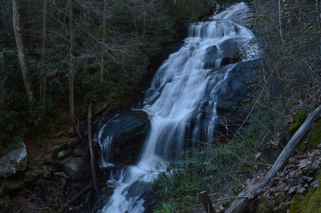
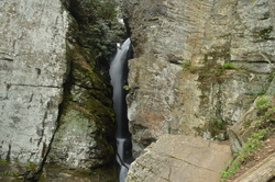
The southeast quadrant of the Tray Mountain Wilderness is home to the headwaters of the Soquee River. Numerous streams join to form the West, Middle, and East Prongs of the Left Fork of the Soquee River, and it is likely that all of the streams have undocumented waterfalls. The grandest of them all is the middle waterfall on the Left Fork: a powerful and remote multi-tier 75-foot waterfall with surprisingly easy access. On the hike to this waterfall, you will also visit the smaller but beautiful lower waterfall and have the options of visiting bonus waterfalls, such as Wolfpen Branch Falls and the upper waterfall on the Left Fork of the Soquee River. This hike occurred on Saturday, April 8th, 2017. My plan was to scout out the easiest route to the biggest waterfall on the Left Fork of Soquee River, described below. 


Read More
5 Comments

Tray Mountain Wilderness: Chimney Mountain Trail, Helen, Georgia

2/9/2017

1 Comment

 
Picture
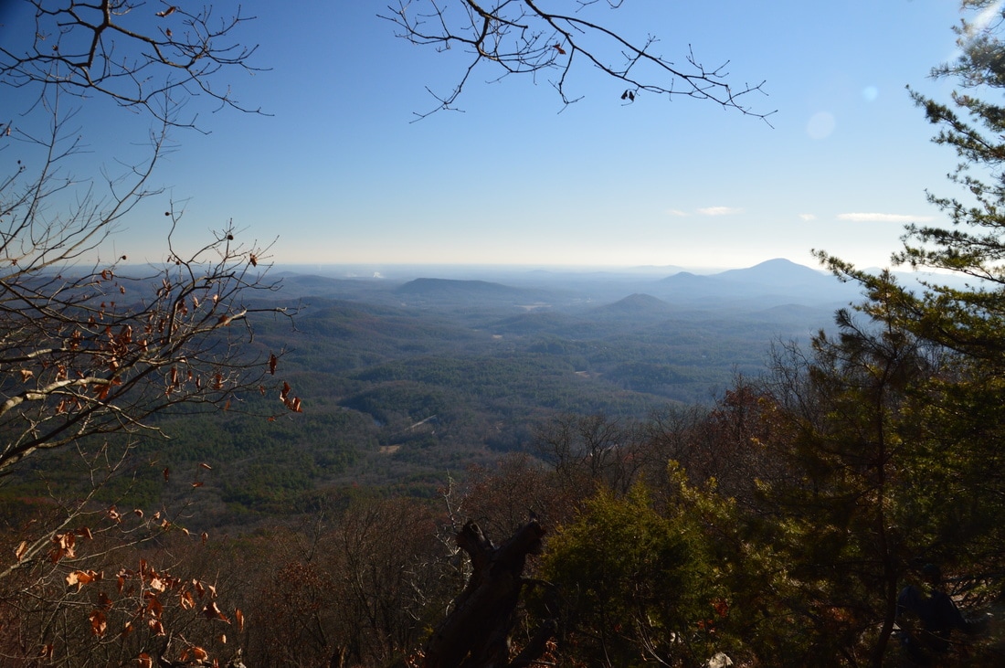
The Tray Mountain Wilderness is perhaps the least-explored wilderness area in Georgia. The focal point of the wilderness is Tray Mountain, which is one of the highest mountains in Georgia, and the section of the Appalachian Trail that passes over Tray Mountain. South and east of Tray Mountain, however, lies a remote area that has largely been unexplored: the Left Fork Soquee River watershed, which is home to numerous waterfalls. On the south side of the watershed stands Chimney Mountain, a lower peak that has several cliffs with great views but is overshadowed by the taller Tray Mountain only a few miles away. The hike to Chimney Mountain follows an unofficial trail that leads to a panoramic vista that faces Mount Yonah and the Georgia Piedmont. This hike occurred on Saturday, December 10th, 2016. My plan was to hike the unofficial path to Chimney Mountain out and back. 


Read More
1 Comment

Chattahoochee National Forest: Andrews Cove Trail, Rocky Mountain Loop, and Appalachian Trail from Indian Grave Gap to Tray Mountain, Helen, Georgia

12/1/2016

0 Comments

 
Picture
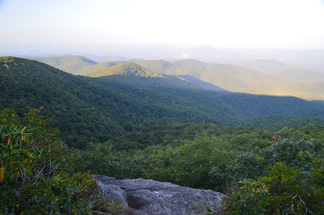
Rocky Mountain and Tray Mountain are two rocky peaks with impessive views on the Appalachian Trail in north Georgia near Helen. Tray Mountain is also the seventh-highest mountain in Georgia. Other than the Appalachian Trail, a couple of additional trails are used to access the area. The Rocky Mountain Trail bends around the northern side of Rocky Mountain, which serves as a bypass for the rocky summit area of Rocky Mountain as well creates a popular loop hike. The Andrews Cove Trail begins nearly two thousand feet below the summit of Rocky Mountain and ascends through a lush mountain cove past several small tumbling streams before joining the Appalachian Trail. On this hike, you will first ascend along the Andrews Cove Trail to the Appalachian Trail, before hiking the Rocky Mountain Loop past the great views from the namesake peak, and finishing with an outing along the AT to the summit of Tray Mountain, where more views await. This hike occurred on Saturday, September 10th, 2016. My plan was to hike the Andrews Cove Trail to the Appalachian Trail at Indian Grave Gap. From there, I would hike the Rocky Mountain Loop clockwise, and then, I would hike the Appalachian Trail out and back to the summit of Tray Mountain as well as locate a little-known vista on the mountain's east side. I would finish by retracing my steps along the Andrews Cove Trail. 


Read More
0 Comments

Smithgall Woods State Park: Laurel Ridge Trail, Wetlands Loop Trail, Martin's Mine Trail, Cathy Ellis Trail, Ash Creek Trail, and Dukes Creek Falls, Helen, Georgia

10/20/2015

1 Comment

 
Picture
Smithgall Woods State Park, one of the largest state parks in Georgia, is a low-elevation woodlands tract near the tourist town of Helen. Through the center of the park flows Dukes Creek.This hike revolves around Dukes Creek, visiting several waterfalls on tributaries as well as the main show, Dukes Creek Falls. This hike occurred on Saturday, August 8th, 2015. My plan was to hike the Laurel Ridge Trail clockwise, and then follow Tsalaki Trail (a paved road that is closed to vehicles) to several various trails: Wetlands Loop, Martin's Mine Trail, Cathy Ellis Trail, and Ash Creek Trail. After completing all of these trails, I would also head upstream along Dukes Creek and take the Dukes Creek Falls Access Trail to Dukes Creek Falls.


Read More
1 Comment

Chattahoochee National Forest: Horsetrough Falls and Chute Falls, Helen, Georgia

5/6/2015

1 Comment


Read More
1 Comment

Raven Cliffs Wilderness: Raven Cliff Falls Trail, Helen, Georgia

5/4/2015

1 Comment

 
Picture
Raven Cliff Falls is one of the most unique waterfalls in Georgia. Dodd Creek falls 80 feet through a narrow crevice in a large cliff, followed by a 20-foot cascade before becoming peaceful. Dodd Creek also makes several more significant drops, as it grows in size, before reaching the main show where it joins Davis Creek to become Dukes Creek - the 200-foot Dukes Creek Falls - although that one isn't quite on this hike. The 5-mile trail to Raven Cliff Falls is an excellent way to introduce yourself to hiking, as it's a good first hike. For the more experienced, a slim route, along a rock jumble and up a root ladder leads to the top of the cliff which is home to Raven Cliff Falls. This hike occurred on Saturday, April 18, 2015. My plan was to hike the Raven Cliff Falls Trail out and back from the trailhead. 


Read More
1 Comment

    About Me

    Mark Oleg Ozboyd
    I'm an avid outdoor explorer and a hobbyist landscape photographer. I'm 21 years old and have been hiking since 2011. Originally based out of Atlanta, Georgia, I started out by occasionally hiking short trails throughout well-known Georgia State Parks. During 2012 and 2013, I began to expand my trips into adjacent states, as well as into the wilder National Forest areas rather than just State Parks. Throughout the years that followed, as I slowly ran out of popular hiking trails in my area, I began to search for and hike in more seldom-visited areas. Today, you can find me out in the woods every weekend, whether it's on an official trail or bushwhacking through cross-country terrain without any paths. I now attend Washington & Lee University and am exploring Virginia and West Virginia. My other hobbies include chess, science, old music, and meteorology. I have 3 years of amateur weather forecasting experience, having studied a lot of meteorology basics over the years. I am also a student at European School of Music where I learned that music and nature have a lot in common. Listening to good music inspires me to capture nature's beauty on the camera in different aspects that also make me recall many beautiful music pieces that I've heard.​


    Dear readers: I have invested a tremendous amount of time and effort in this website and the Georgia Waterfalls Database the past five years. All of the work that has gone in keeping these websites updated with my latest trip reports has almost been like a full-time job. This has not allowed me to pick up a paid job to save up money for college, and therefore, I I've had to take out loans. If you find the information on this website interesting, helpful, or time-saving, you can say "thanks" and help me out by clicking the button above and making a contribution. I will be very grateful for any amount of support you give, as all of it will apply toward my college tuition. Thank you! 

    Enter your email address to subscribe for trail reports:

    Delivered by FeedBurner


    Picture
    Coming in 2022-2023?

    Other Hiking Websites

    DWHike's Adventures
    Florida's Natural Wonders
    Florida Trailblazer
    Meanderthals
    Mountain Images
    by Bernie Boyer

    North Carolina Waterfalls with
    ​Kevin Adams
    Take-a-Hike!
    Tennessee Landforms
    Waterfall Page
    Waterfall Adventurer
    Zach's Mild Adventures

    Miles Hiked

    Year 1: 540.0 Miles
    Year 2: 552.3 Miles
    ​Year 3: 518.4 Miles
    Year 4: 482.4 Miles
    Year 5: 259.9 Miles

    Archives

    March 2021
    February 2021
    January 2021
    November 2019
    October 2019
    September 2019
    August 2019
    July 2019
    June 2019
    February 2019
    January 2019
    December 2018
    November 2018
    October 2018
    August 2018
    July 2018
    June 2018
    May 2018
    April 2018
    March 2018
    February 2018
    January 2018
    December 2017
    November 2017
    October 2017
    September 2017
    August 2017
    July 2017
    June 2017
    May 2017
    April 2017
    March 2017
    February 2017
    January 2017
    December 2016
    November 2016
    October 2016
    September 2016
    August 2016
    June 2016
    May 2016
    April 2016
    March 2016
    January 2016
    December 2015
    November 2015
    October 2015
    September 2015
    August 2015
    July 2015
    June 2015
    May 2015
    April 2015
    March 2015
    February 2015
    January 2015
    December 2014
    November 2014
    October 2014
    September 2014
    August 2014
    July 2014
    June 2014
    May 2014
    April 2014
    March 2014
    February 2014

    Categories

    All
    Adel
    Adirondack Park
    Alabama
    Alfred A. Ring Park
    Allegheny Trail
    Amicalola Falls State Park
    Anniston Area
    Apalachicola Bluffs And Ravines Preserve
    Apalachicola National Forest
    Apalachicola/Port St. Joe Area
    Apopka
    Appalachian Trail
    Appling
    Art Loeb Trail
    Aska Trail System
    Bakersville
    Balm-Boyette Scrub Preserve
    Balsam Lake Recreation Area
    Bankhead National Forest
    Bartow County Parks
    Bartram Trail
    Basinger
    Beersheba Springs
    Benton
    Benton Mackaye Trail
    Berry College Trail System
    Best Hike
    Big South Fork National Recreation Area
    Black Bear Wilderness
    Black Rock Mountain State Park
    Blairsville
    Blakely
    Blood Mountain Wilderness
    Blowing Rock
    Blue Ridge
    Blue Ridge Parkway
    Boone
    Bradenton
    Bradenton Beach
    Brasstown Bald
    Brasstown Wilderness
    Brevard
    Bryson City
    Buchanan
    Bucks Pocket State Park
    Bulow Creek State Park
    Bulow Plantation Ruins State Park
    Caesars Head State Park
    Caladesi Island State Park
    Calhoun
    Camel's Hump State Park
    Cashiers
    Caspersen Beach Park
    Catfish Creek State Park
    Caves
    CC Putnam State Forest
    Cedar Point Environmental Park
    Chatsworth
    Chattahoochee National Forest
    Chattanooga
    Chattanooga Valley
    Chattooga National Wild And Scenic River
    Cheaha Wilderness
    Cherohala Skyway
    Cherokee
    Cherokee National Forest
    Chiefland Area
    Chillhowee Recreation Area
    Chipley
    Chunky Gal Trail
    Circle B Bar Reserve
    Citico Creek Wilderness
    Citrus Wildlife Management Area
    Clarkesville
    Clayton
    Cleevland
    Cleveland
    Cloudland Canyon State Park
    Cohutta Wilderness
    Collier-Seminole State Park
    Cordele
    Cornelia
    Covington
    Crestview Area
    Crew-land-and-water-trust
    Cullowhee
    Cumberland Trail
    Dahlonega
    Dalton
    Dawson Forest Wildlife Management Area
    Dawsonville
    Dayton
    De Soto National Memorial
    DeSoto State Park
    Dillard
    Double Springs
    Ducktown
    Duncan Ridge Trail
    Dunlap
    Eagle's Rest Park
    Eastpoint
    Econfina Creek Wildife Management Area
    Eglin Air Force Base
    Elizabethton
    Elkins
    Elk Knob Game Lands
    Elk Park
    Ellicott Rock Wilderness
    Ellijay
    Emerson Point Preserve
    Englewood Area
    Enota Retreat
    Erwin
    Falling Waters State Park
    Fayetteville
    Fires Creek Recreation Area
    Fire Tower
    Flint River
    Florence Area
    Florida
    Florida Caverns State Park
    Florida Trail
    Foothills Trail
    Fort Mountain State Park
    Fort Myers Area
    Fort Payne
    Fort Payne Area
    Fort Yargo State Park
    Franklin
    Franklin Delano Roosevelt State Park
    Franklin-Marion State Forest
    Frozen Head State Park
    Gainesville
    Gainesville Area
    Gatlinburg
    George Washington National Forest
    Georgia
    Georgia Veterans Memorial State Park
    Glasgow
    Gorges State Park
    Grandfather Mountain State Park
    Great Smoky Mountains National Park
    Greeneville
    Green River Game Lands
    Gruetli-Laager
    Grundy Forest State Natural Area
    GTM Reserve
    Guana River Wildlife Management Area
    Hayesville
    Helen
    Hiawassee
    High Falls State Park
    Highlands
    Highlands Scenic Highway
    Hillsborough River State Park
    Hinson Conservation & Recreation Area
    Historic Sites
    Honeymoon Island State Park
    Hot Springs
    Huntington
    Inverness Area
    Jackson
    Jasper
    Jefferson National Forest
    Joan M. Durante Park
    Jonathan Dickinson State Park
    Jones Gap State Park
    Joyce Kilmer Slickrock Wilderness
    Joyce Kilmer - Slickrock Wilderness
    Juniper Prairie Wilderness
    Kelly Park
    Keown Falls Recreation Area
    Kolomoki Mounds State Park
    LaFayette
    Lake City Area
    Lake George Wild Forest
    Lake June-in-Winter State Park
    Lakeland Area
    Lake Placid
    Lake Russell Wildlife Management Area
    Lake Wales Ridge State Forest
    Laurel Fork North Wilderness
    Leffis Key Preserve
    Leon Sinks Geological Area
    Lexington
    Lineville
    Linville
    Linville Gorge Wilderness
    Lithia Springs
    Little Frog Wilderness
    Little Manatee River State Park
    Little River Canyon National Preserve
    Longboat Key
    Long Trail
    Lookout Mountain
    Lookout Mountain Battlefield
    Lovingston
    Lula Lake Land Trust
    Lumpkin
    Maggie Valley
    Manatee Springs State Park
    Marianna Area
    Mark Trail Wilderness
    Marlinton
    Mccaysville
    McMinville
    Mentone
    Middlesex
    Mistletoe State Park
    Monongahela National Forest
    Montreat
    Mountain Bridge Wilderness Area
    Mountain City
    Mountains To Sea Trail
    Mountains-to-Sea Trail
    Mount Rogers National Recreation Area
    Myakka River State Park
    Myron B. Hodge City Park
    Nantahala National Forest
    Naples
    Naples Area
    Natural Bridge State Park
    Neal Preserve
    New Castle
    Newport
    New River Gorge National Park
    New York
    North Carolina
    Ocala Area
    Ocala National Forest
    Ocean-to-Lake Trail
    Oconee State Park
    Oconee Station Historic Site
    Okaloacoochee Slough State Forest
    Oldsmar
    Oneida
    Orlando Area
    Ormond Beach
    Oscar Scherer State Park
    Oxford
    Palatka
    Palmetto Trail
    Panama City Area
    Panthertown Valley
    Parrish
    Paynes Creek Historic State Park
    Peaks Of Otter Recreation Area
    Pigeon Crockford Mountain Wildlife Management Area
    Pigeon-Crockford Mountain Wildlife Management Area
    Pigeon-Crockford Wildlife Management Area
    Pine Mountain
    Pinhoti Trail
    Pinnacle Park
    Pisgah Civitan Park
    Pisgah National Forest
    Pittman Center
    Pond Mountain Wilderness
    Ponds/Lakes
    Prentice Cooper State Forest
    Providence Canyon State Park
    Pumpkintown
    Quick Point Nature Preserve
    Raven Cliffs Wilderness
    Reed Bingham State Park
    Reliance
    Rice Creek Conservation Area
    Riverview Pointe Preserve
    Robbinsville
    Robinson Preserve
    Rock Creek Gorge Scenic Area
    Rock Island State Park
    Rome
    Rosman
    Sale Creek
    Salem
    Salt Springs
    Saluda
    Santa Rosa Beach
    Sarasota
    Sarasota Area
    Savage Gulf State Natural Area
    Scenic Views
    Scottsboro Area
    Sebring Area
    Sewanee
    Sheltowee Trace Trail
    Shining Rock Wilderness
    Signal Mountain
    Sipsey Wilderness
    Sky Valley
    Smithgall Woods State Park
    Snowbird Backcountry Area
    Soddy Daisy
    Soddy-Daisy
    Sopchoppy
    South Carolina
    South Cumberland State Park
    Southeastern Cave Conservancy
    Southern Nantahala Wilderness
    Sparta
    Sprewell Bluff Park
    Spring City
    Spring Hill
    Springs
    Spruce Pine
    Standing Indian Backcountry Area
    St. Augustine
    St. George Island State Park
    St. Joseph Bay State Buffer Preserve
    St. Marks Area
    St. Marks National Wildlife Refuge
    Stone Mountain
    Stone Mountain Park
    Suches
    Sumatra
    Sumter National Forest
    Suwannee River
    Swallow Creek Wildlife Management Area
    Sweetwater Creek State Park
    Sylva
    Talladega National Forest
    Tallahassee Area
    Tallulah Falls
    Tallulah Gorge State Park
    Tampa Bay Area
    Tate City
    Tate's Hell State Forest
    Tea Creek Wildlife Management Area
    Tellico Plains
    Tennessee
    Thomaston
    Toccoa
    Topsail Hill State Park
    Torreya State Park
    Townsend
    Tracy City
    Tray Mountain Wilderness
    Trenton
    Triple Creek Preserve
    Troutdale
    Unaka Mountain Wilderness
    Upper Tampa Bay County Park
    Venice
    Vermont
    Virgin Falls State Natural Area
    Virginia
    Virginia Outdoors Foundation
    Vogel State Park
    Wakulla Springs State Park
    Waleska
    Walhalla
    Wartburg
    Water Features
    Waynesville
    Weedon Island Preserve
    Weeki Wachee Preserve
    Wekiwa Springs State Park
    West Palm Beach Area
    West Virginia
    Whitehall
    White Springs
    Winder
    Withlacoochee State Forest
    Young Harris

    RSS Feed

TRAIL REPORTS

Hikes in Alabama
​Hikes in Florida
Hikes in Georgia
Hikes in North Carolina
Hikes in South Carolina
Hikes in Tennessee
Hikes in Virginia

Hiking Resources

Alabama Resources
​
Florida Resources
Georgia Resources
North Carolina Resources
​South Carolina Resources
​
Tennessee Resources

Other

Contact
Map of Hikes
Alphabetical List of Hikes
Southeast Nature Society
© COPYRIGHT 2014-2018
​ALL RIGHTS RESERVED.
Important: I disclaim any responsibility for any damage or personal injury that may occur as a result of the activities and information found on this website. All outdoor activities, especially off-trail hiking, are done at your own risk. Never hike or head into that area that may be above your fitness or experience level.
  • Home
  • Trail Reports
    • Best Hikes
    • Hikes with Scenic Views
    • Hikes with Water Features
    • Alabama
    • Georgia
    • Florida
    • North Carolina
    • South Carolina
    • Tennessee
    • Vermont
    • Virginia
  • Map
  • Hike List
  • Testimonials
  • Resources
  • Contact Us
  • Southeast Nature Society
    • Our Team
  • Georgia Waterfalls Database