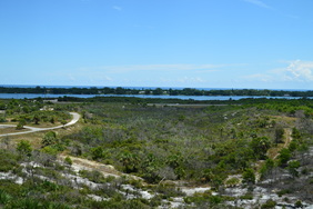
South Florida is best known for its sugar cane farms, swamps such as the Everglades, cities like Miami and Naples, and Lake Okeechobee. One of the more secret special places is a relatively little-known "hill" called Hobe Mountain - an ancient sand dune near Jupiter Island that rises to a height of 84 feet above sea level. In this mostly flat land, Hobe Mountain is a unique location, which has an observation tower that is most easily accessed using a short boardwalk in Jonathan Dickinson State Park. Jonathan Dickinson State Park itself is a mecca for outdoor recreation enthusiasts, as it has over two dozen miles of hiking trails, in addition to many other recreational opportunities. On this day, I first hiked the short trail to Hobe Mountain, before embarking on a much longer hike through the park. This hike occurred on Saturday, July 23rd, 2016. My plan was to hike the boardwalk out and back to Hobe Mountain and its observation tower.
2 Comments
Triple Creek Preserve and Balm-Boyette Scrub Preserve Hiking Trail, Sun City Center, Florida10/23/2016 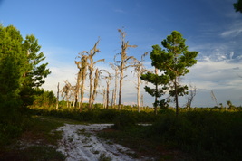
The Florida scrub is an endangered habitat that is found mainly on sand ridges throughout the state. It is relatively common to encounter a scrub in central Florida along the Lake Wales Ridge, as well as in coastal areas of eastern Florida and the state's panhandle. However, Balm-Boyette Scrub is one of a few rare scrubs in west Florida and around the Tampa area, which makes it more special than some of the scrubs on the Lake Wales Ridge. Two preserves adjacent to each other facilitate hiking access into the scrub. The main hiking trail also passes past several creeks, all of which are tributaries of the Alafia River. This hike occurred on Wednesday, July 20th, 2016. My plan was to hike clockwise the loop trail that passes through both Triple Creek Preserve and Balm-Boyette Scrub Preserve.
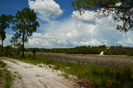
Catfish Creek State Park is in an area of Florida called the Lake Wales Ridge: a long elevated strip of land in central Florida with elevation peaking at 312 feet on Sugarloaf Mountain. Originally, the ridge was a series of "sand islands" over a million years ago, when most of the rest of Florida was actually underwater. Much of the Lake Wales Ridge has unaltered, conserved scrub habitat, which is essential for the areas dozens of endangered plants and animals, such as the sand skink, gopher tortoise, and scrub jay. On this hike, you'll scramble up to some of the region's highest hills, with their dazzling bright sand, as well as drop down into shady depressions where lakes abound. Additionally, you'll visit the site of an old sod farm and get to see some of the remaining structures - if they're still there by the time you're reading this. This hike occurred on Saturday, July 16th, 2016. My plan was to begin hiking the long loop counter-clockwise, before taking the medium loop connector across to the other side of the loop. From there, I would begin hiking the long loop in the clockwise direction, but not for long - I would then hike out and back the side trail to the sod farm ruins. After this, I would hike the long loop to the medium loop connector, and after hiking the connector for a second time, I would hike the remaining section of the long loop.
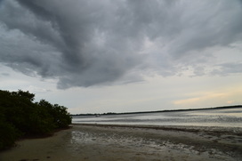
Cedar Point Environmental Park is one of two preserves that are operated by the Charlotte Harbor Environmental Center, with the other one being the Charlotte Harbor Environmental Park south of Punta Gorda. Cedar Point Environmental Park protects 130 acres of land along Lemon Bay. The park's namesake is Cedar Point, a small promontory that stretches out into Lemon Bay, separating the bay from Oyster Creek. On this hike, you will first be treated to a couple views of Oyster Creek just east of its mouth, before seeing Lemon Bay itself from Cedar Point. Much of the hike is in pine flatwoods or palm hammocks, but for the tiny size of this parcel of land, the feeling of remoteness is greater than one would expect. This hike occurred on Wedneday, July 13th, 2016. My plan was to make an outer loop across the entire Cedar Point Environmental Park's extremely confusing trail system. I would make a side trip to Cedar Point along the way.
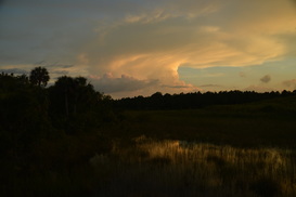
The chief attraction of Okaloacoochee Slough State Forest is the namesake Okaloacoochee Slough: a long, pristine north-south slough that is one of the areas of southwest Florida, outside of the Everglades, still in its pre-Columbian state. Okaloacoochee Slough State Forest is also one of the few places in Florida where you can spot the elusive Florida panther. There are several hiking trails in the forest, but on this day, my plan was to simply hike the short nature trail. This trail ends at a boardwalk that provides a great panorama of the slough, where you can spot alligators in the water and deer splashing through the wetlands. This hike occurred on Saturday, July 9th, 2016. My plan was to hike the short nature trail to the end of the boardwalk and back.
|
About MeMark Oleg Ozboyd Dear readers: I have invested a tremendous amount of time and effort in this website and the Georgia Waterfalls Database the past five years. All of the work that has gone in keeping these websites updated with my latest trip reports has almost been like a full-time job. This has not allowed me to pick up a paid job to save up money for college, and therefore, I I've had to take out loans. If you find the information on this website interesting, helpful, or time-saving, you can say "thanks" and help me out by clicking the button above and making a contribution. I will be very grateful for any amount of support you give, as all of it will apply toward my college tuition. Thank you!

Coming in 2022-2023?
Other Hiking WebsitesMiles HikedYear 1: 540.0 Miles
Year 2: 552.3 Miles Year 3: 518.4 Miles Year 4: 482.4 Miles Year 5: 259.9 Miles Archives
March 2021
Categories
All
|
 RSS Feed