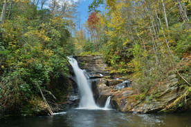
Southwest North Carolina's Wolf Creek sure is a potent stream with the six major waterfalls it is home to. The tallest and best-known waterfall on the creek is Wolf Creek Falls aka Paradise Falls below Wolf Creek Lake. But higher up on Wolf Creek is a set of four breathtaking pristine waterfalls clustered close together near Balsam Lake. The series of falls culminates with Lauren Falls, a spectacular near free-fall with a deep pool surrounded by beautiful water-sculpted rock outcrops. The hike to these waterfalls, especially Patricia Falls and Lauren Falls, is quite difficult as it involves a lot of off-trail scrambling, but less experienced hikers have the choice to hike just to the first waterfall, Balsam Falls, which is considerably easier to reach with only minimal scrambling. Along the way, visitors will be treated to many gorgeous views of Balsam Lake along the Mallonee Trail. This hike occurred on Saturday, October 14th, 2017. My plan was to hike to the Mallonee Trail along Balsam Lake from Balsam Lake Recreation Area to Balsam Lake Dam, from where I would follow faint paths to Balsam Falls, Lower Balsam Falls, Patricia Falls, and Lauren Falls. I would return the same way.
0 Comments
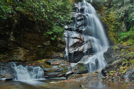
The Little Canada area of Southwest North Carolina is home to a vast array of majestic waterfalls, and Sols Creek is one of the area's signature creeks. Few North Carolina waterfalls are as jaw-dropping as Sols Creek Falls near the creek's lower end, but unfortunately, that falls is on private property. In contrast, Upper Sols Creek Falls is on National Forest land and is nearly as impressive as its taller brother. Tumbling 65 feet down a huge cliff, Upper Sols Creek Falls is a spectacular waterfall and falls into a fairly easy-to-reach category. The unofficial trail to the falls has a few creek crossings but is mostly in good shape and can be walked by hikers of nearly all levels. In fact, the most difficult part of the hike may be finding the obscure trailhead and pullout parking. This hike occurred on Saturday, October 14th, 2017. My plan was to hike out and back to Upper Sols Creek Falls from NC Route 281.
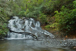
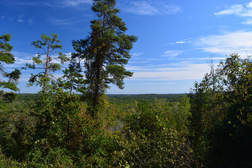
While the views atop Big Cedar Mountain along the Appalachian Trail are well-known, its lower brother Little Cedar Mountain on the other side of the quaint community of Suches is far more obscure. Despite this, a good trail leads to Little Cedar Mountain, where a set of cliffs provides a great view into the Canada Creek valley. The picturesque view is only the beginning though - a connecting trail leads deep into the Canada Creek valley, where a set of four breathtaking waterfalls await. Ranging from only 15 to over 50 feet high, all four waterfalls are fairly easy to reach thanks to an intricate network of unofficial trails along forest roads and fainter paths up and down the Canada Creek watershed. This hike occurred on Saturday, October 7th, 2017. My plan was to hike from Highway 60 to the vista atop Little Cedar Mountain. From there, I would scout out one route down into the Canada Creek valley and another on my way back (as I learned, only one route had a trail). Once in the valley, I would follow trails to Canada Creek Falls, Ontario Falls, and Alberta Falls, and if time permitted, Yukon Falls too.
The Frady Branch Trail System is an often-overlooked collection of trails in the Lake Russell Wildlife Management Area near Toccoa. Even though the Frady Branch Trail System is located entirely in a low-elevation area with no mountain views, it has a surprising amount of points of interest, including three historic homesites, a small quarry, two ancient cemeteries, and perhaps most importantly: a 50-foot waterfall in the headwaters of Big Leatherwood Creek. Even though Big Leatherwood Falls is less than a quarter-mile from an official trail, it is a very little-known waterfall in a gorgeous pristine setting. Additionally, there is a second smaller waterfall along the loop - although both waterfalls are best seen during wet periods when they have the most water in them. This hike occurred on Saturday, September 30th, 2017. My plan was to hike the perimeter loop along the Frady Branch Trails clockwise.
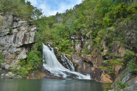
Tallulah Gorge is an anomaly in Georgia. The cliff-lined gorge through which the Tallulah River flows is nearly 1000 feet deep in places, and there's no other gorge of this magnitude anywhere else in the state. Tallulah Gorge State Park encompasses all of the gorge below Tallulah Falls Dam and has a number of hiking trails that provide access into the gorge. While some trails follow the rims with breathtaking views of the gorge, a different trail descends hundreds of steps to Hurricane Falls deep in the gorge. From there, one can follow a rugged and rocky footpath known as the Gorge Floor Trail along the river and past two other waterfalls, but a Gorge Floor Permit is necessary for this - and only 100 are issued per day. The extremely steep climb back out along the Sliding Rock Trail is an exciting rock scramble with more views of the cliffs. Lastly, before concluding the hike, you'll have the chance to stop by Inspiration Point - a sweeping panorama that is arguably the best view of Tallulah Gorge. This hike occurred on Saturday, September 30th, 2017. My plan was to hike the Gorge Floor Loop clockwise, later making a side trip to Inspiration Point.
|
About MeMark Oleg Ozboyd Dear readers: I have invested a tremendous amount of time and effort in this website and the Georgia Waterfalls Database the past five years. All of the work that has gone in keeping these websites updated with my latest trip reports has almost been like a full-time job. This has not allowed me to pick up a paid job to save up money for college, and therefore, I I've had to take out loans. If you find the information on this website interesting, helpful, or time-saving, you can say "thanks" and help me out by clicking the button above and making a contribution. I will be very grateful for any amount of support you give, as all of it will apply toward my college tuition. Thank you!
Coming in 2022-2023?
Other Hiking WebsitesMiles HikedYear 1: 540.0 Miles
Year 2: 552.3 Miles Year 3: 518.4 Miles Year 4: 482.4 Miles Year 5: 259.9 Miles Archives
March 2021
Categories
All
|

 RSS Feed