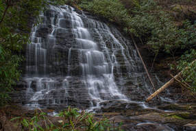
The Ellicott Rock Wilderness Area covers over 8000 acres across Georgia, South Carolina, and North Carolina. The wilderness's namesake is Ellicott Rock, located in the very heart of the wilderness at the point where all three states come together. From Burrells Ford, one can follow the Chattooga River Trail north into the wilderness all the way to Ellicott Rock and beyond. Besides passing Spoonauger Falls, the Chattooga River Trail affords numerous views of the river that it closely follows all the time. The other waterfall in the vicinity of Burrells Ford, King Creek Falls, is also easily-accessed and is among the most breathtaking waterfalls of the region. Intrepid waterfall chasers can also pick up the Bad Creek Trail from Ellicott Rock and make a challenging bushwhack to a secluded and pristine waterfall on Fowler Creek. This hike occurred on Saturday, January 27th, 2018. My plan was to first hike the Foothills Trail from Burrells Ford Campground to King Creek Falls. Then, I'd take the King Creek Trail and connect to the Chattooga River Trail. I'd follow the Chattooga River Trail north into the Ellicott Rock Wilderness all the way to Ellicott Rock, making the side trip to Spoonauger Falls along the way. From Ellicott Rock, I would follow the Bad Creek Trail and bushwhack down to Fowler Creek Falls. I would retrace most of my steps from Fowler Creek Falls, but when I would return to the vicinity of Spoonauger Falls, I would take the Foothills Trail straight to Burrells Ford Campground.
1 Comment
Caesars Head State Park/Mountain Bridge Wilderness: Naturaland Trust Loop, Cleveland, South Carolina1/25/2018 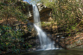
The west half of the Mountain Bridge Wilderness is encompassed by Caesars Head State Park, named for a prominent rock outcrop with striking views of the South Carolina Upstate. One of the area's main highlights is Raven Cliff Falls, a majestic waterfall on Matthews Creek that is cited to be 420 feet high. Among the wilderness's most scenic trails, the Naturaland Trust Trail provides direct access into the Matthew Creek gorge, passing views of Raven Cliff Falls after crossing an elegant suspension bridge at the waterfall's top. Several other trails in the park can be used to create the 12-mile loop Naturaland Trust Loop, which is not only among South Carolina's top hikes but also a very strenuous one. An added bonus for hiking the full loop, however, is optional access to two more gorgeous waterfalls on the property of Asbury Hills Camp: Moonshine Falls and Confusion Falls. This hike occurred on Saturday, January 20th, 2018. My plan was to hike the Naturaland Trust Loop clockwise from the Raven Cliff Falls parking area, although I came away with the feeling that hiking the loop counter-clockwise is better.
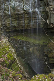
Chamberlain Trail is one of only two trails that ascends the east side of Pigeon Mountain from base to top. This lesser-known trail climbs at an easy to moderate pace through Atwood Gulf before meeting up with the Atwood Trail atop the mountain. While there aren't any notable attractions along the trail itself, a fantastic natural sight lies off-trail in Atwood Gulf: Nash Pit Falls. Have you ever heard the words pit and waterfall in one sentence? At Nash Pit Falls, a small stream flows out of a cave and instantly drops over 70 feet into the Nash Pit, a small but deep hole in the ground. In addition to the stunning Nash Pit Falls, this hike also visits a pair of McLemore Cove vistas on High Point - the highest point on Pigeon Mountain. This hike occurred on Saturday, January 13th, 2018. My plan was to hike the Chamberlain Trail from Chamberlain Road to Atwood Trail, making the bushwhack to Nash Pit Falls along the way. Next, I would follow the Atwood Trail to the Pocket/Bluff Trail. I would then follow the Pocket Trail and Bluff Trail in conjunction to the views on High Point. I would retrace my steps the same way.
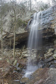
The Lost Wall is a bluff line that follows the east side of Pigeon Mountain for several miles. It's popular with rock climbers, and a trail follows the cliffs, passing many climbing access points. Only 0.15 miles from the trail's beginning at Rocky Lane, Dickson Creek comes over the Lost Wall and forms a 70-foot waterfall. During wet periods, free-falling Dickson Falls is one of the best waterfalls in the northwest corner of Georgia. The best part about it is how easily one can get to it! This hidden jewel is great for the whole family. This hike occurred on Saturday, January 13th, 2018. My plan was to hike the unofficial Lost Wall Trail out and back to Dickson Falls.
Apalachicola National Forest: Leon Sinks Geological Area Trail System, Tallahassee, Florida1/9/2018 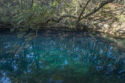
The Leon Sinks Geological Area is in the northeast corner of Apalachicola National Forest near Tallahassee. This fascinating area is home to over a dozen sinkholes, many of which have water in them. Particularly Hammock Sink is one of the most beautiful and photogenic natural sights in the region. The trail system at Leon Sinks also visits a disappearing stream with a natural bridge as well as a series of cypress swamps. Numerous points of interest are spaced throughout the 4.5-mile loop to keep your attention focused the entire hike. This hike occurred on Saturday, January 6th, 2018. My plan was to hike a counter-clockwise loop with the Sinkhole Trail and Gum Swamp Trail.
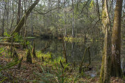
Most hikers of the Tallahassee area have heard of or even been to Leon Sinks. How many have heard of Wakulla River Sinks though? Along with adjacent Apalachicola National Forest, the River Sinks Tract - a lesser-known parcel of Wakulla Springs State Park - holds nearly two dozen water-filled sinkholes. The sinks serve as a portal to the mysterious underground water-filled cave system that eventually connects to the Wakulla River to the southeast. An official trail called the Wakulla River Sinks Trail passes by several small sinks, including the photogenic Clearcut Sink. If one extends their hike along the unofficial pathway that splits off and leads to a series of bigger sinks, including Promise Sink and Upper River Sink, they are bound to be astounded! This hike occurred on Saturday, January 6th, 2018. My plan was to hike the official Wakulla River Sinks Trail clockwise. Along the way, I would make out-and-back side trips to Clearcut Sink and along an unofficial trail to a series of sinks to the south.
|
About MeMark Oleg Ozboyd Dear readers: I have invested a tremendous amount of time and effort in this website and the Georgia Waterfalls Database the past five years. All of the work that has gone in keeping these websites updated with my latest trip reports has almost been like a full-time job. This has not allowed me to pick up a paid job to save up money for college, and therefore, I I've had to take out loans. If you find the information on this website interesting, helpful, or time-saving, you can say "thanks" and help me out by clicking the button above and making a contribution. I will be very grateful for any amount of support you give, as all of it will apply toward my college tuition. Thank you!
Coming in 2022-2023?
Other Hiking WebsitesMiles HikedYear 1: 540.0 Miles
Year 2: 552.3 Miles Year 3: 518.4 Miles Year 4: 482.4 Miles Year 5: 259.9 Miles Archives
March 2021
Categories
All
|

 RSS Feed