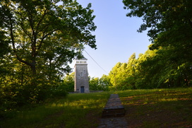
The Lake Russell trail system is often overlooked by hikers, who are interested in the "true" mountain hiking just a short drive to the north of Cornelia. The Lake Russell Recreation Area does not sit in the actual mountains, but these foothills provide quality hiking nonetheless. Several hiking trails can be found around Lake Russell and Nancytown Lake. On this hike, you will first see a couple of waterfalls on Nancytown Creek, before hiking along the shores of Nancytown Lake and then Russell Lake. The route becomes more difficult as the hike follows a seldom-used trail to the top of Chenocetah Mountain, where an old fire tower stands. Before your return to Nancytown Lake along a different trail, make sure to stop by the two clearings on Chenocetah Mountain that provide some views of Lake Russell and the distant Blue Ridge Mountains. This hike occurred on Saturday, May 7th, 2016. My plan was to hike several of the trails in the Lake Russell trail system. First, I would hike the Sourwood Trail. Then, I would take the Nancytown Lake Trail along the eastern shore of the lake, before connecting to the Lake Russell Loop and hiking the eastern and southern sides of the loop. From there, I would walk a short section of Lake Russell Road before taking the Campground Trail to the top of Chenocetah Mountain. I would return to Nancytown Lake using the Rhododendron Trail.
2 Comments
Foothills Trail: Musterground Road to Hilliard Falls to Horsepasture River, Salem, South Carolina6/18/2016 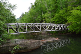
The 77-mile Foothills Trail straddles the North Carolina and South Carolina border for much of its trek through the Southern Blue Ridge Escarpment. One particular section between SC 130 and US 178 is nearly 30 miles long and is known for very limited road access. A very rough ATV road - used mainly by hunters - called Musterground Road, is open during hunting seasons. This road provides access to the Foothills Trail several miles east of the traditional Lower Whitewater Falls Trailhead. The section of the Foothills Trail east of Musterground Road visits Hilliard Falls, a tall waterfall on Bearcamp Creek, before using forest roads to wind through hills before reaching the Horsepasture River. This hike occurred on Saturday, April 30, 2016. My plan was to use an abandoned forest road to get to the Foothills Trail from Musterground Road. From there, i would follow the Foothills Trail to the Horsepasture River, with a side trip to Hilliard Falls. I would return the same way.
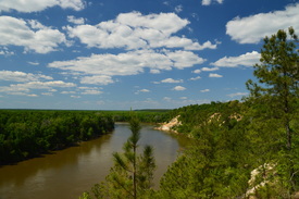
Located near the Apalachicola River, the Apalachicola Bluffs and Ravines Preserve protects one of the most unique habitats in Florida. The preserve has a number of steep ravines with streams flowing through them, and in fact, the preserve's hiking trail provides some of the biggest elevation changes to be found in the state. En route to the Apalachicola River, this hike passes through lush ravines as well as sandhill uplands with some longleaf pines. The highlight of the hike is at Alum Bluff. Positioned 135 feet above the Apalachicola River, this interesting geological formation provides a grand view of the river northward. The hike also makes a short loop through more ravines near the river and past additional sandy bluffs. This hike occurred on Sunday, April 24, 2016. My plan was to hike the Eden of Garden Trail out and back, At the far end of the trail, I would hike the short river loop counter-clockwise.

The coastal Florida Panhandle is well-known for its outstanding beaches. You have probably at least heard names such as Fort Walton Beach, Destin, and Panama City Beach. What most people don't know though is that not all of the beaches between Pensacola and Panama City are developed. A number of state parks, such as Topsail Hill State Park and St. Andrews State Park, are placed along the coast here to protect the fragile ecosystems that are found near the ocean. This part of Florida's coastline is home to fifteen coastal dune lakes - a very rare ecosystem that is found only in four other places: Oregon, Australia, Madagascar, and New Zealand. These lakes are one of the reasons that there is so much conserved land along the shoreline in Walton County. Out of the variety of state parks here, Topsail Hill State Park is the king of them all. This large park has several hiking trails that visit two dune lakes, a remote beach, and a landscape spotted with dunes of all shapes and sizes. This hike occurred on Tuesday, April 19, 2016. My plan was first to follow the paved Beach Tram Path to the Campbell Lake Bike Path, This is where I would take the south side of the Turpentine Trail past a view of Lake Campbell and then to the Deer Track Trail. I would follow the Deer Track Trail's south side to the Morris Lake Trail. After making a side trip to the beach, I would hike the Morris Lake Trail's loop counter-clockwise. Then, I would hike the Old Growth Trail, before hiking the Deer Track Trail's north side. I would finish the hike by following the north side of the Turpentine Trail.
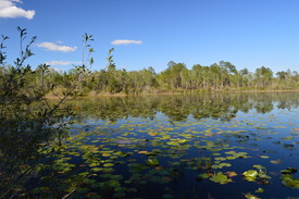
Nearly 80 miles of the Florida Trail pass through Apalachicola National Forest, Florida's largest national forest. At the very northwest end of the forest is Camel Lake, a small natural lake with a campground and a developed recreation area. On its route through the forest, the Florida Trail passes near Camel Lake. Nearby, an alternate trail called the Trail of Lakes can be used to loop this section of the FT. On this loop hike, you will visit two lakes, pass several blackwater streams, and hike through miles of sandhills topped by rows of pine trees. This hike occurred on Sunday, April 17, 2016. My plan was to hike the Trail of Lakes Loop clockwise.
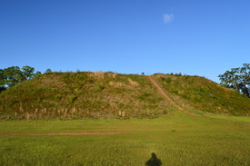
Kolomoki Mounds State Park is home to one of three large complexes of historical Indian mounds in Georgia. The park has the largest and oldest site in the Southeast that used to be occupied by the Woodland Indians. The park's tallest mound - known as the Temple Mound - rises 57 feet high. In addition to the mounds, the park has two lakes and several hiking trails that meander through hilly forest around the lakes. This hike occurred on Saturday, April 16, 2016. My plan was to hike the Temple Mound Trail to the Temple Mound and a couple of other small mounds next to it. Then, I would follow the White Oak Trail through mostly dry forest and across a pair of small streams back to the trailhead.
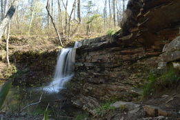
As one of Alabama's first state parks, DeSoto State Park was developed by the Civilian Conservation Corps during the 1930s, and much of their work can still be seen throughout the park today. Located on Lookout Mountain, the park is positioned on the west side of the West Fork of the Little River, conveniently close to the town of Fort Payne. A network of hiking trails visits as many as five waterfalls on tributaries of West Fork Little River. You will also see some views of the Little River gorge and some of the CCC's work on this moderate mountaintop hike. This hike occurred on Saturday, April 2nd, 2016. After completing a short hike to nearby De Soto Falls, I drove down to DeSoto State Park with a plan to make a loop out of several of the park's trail. First, I would take the Talmadge Butler Boardwalk to Azalea Cascade. Then, I would take the Azalea Cascade Trail to the Laurel Falls Trail. I would follow the Laurel Falls Trail to the Lost Falls Trailhead, making sure to make the side trips to Laurel Falls and Lost Falls. After the Lost Falls Trailhead, I would continue on a mountain bike trail that would take me past the CCC Museum and to the CCC Quarry. From the CCC Quarry, I would follow the CCC Quarry Trail to its terminus near the DeSoto State Park Visitor Center. After this, I would cross the park's Picnic and Play Area and follow an access trail to the DeSoto Scout Trail. I would follow the DST north for a little bit to the CCC Trail Shelter and views of the Little River, before turning south and finishing the hike at the park's lodge, passing Indian Falls and Lodge Falls in the meantime. A bit of roadwalk would be necessary to return back to the parking area.
|
About MeMark Oleg Ozboyd Dear readers: I have invested a tremendous amount of time and effort in this website and the Georgia Waterfalls Database the past five years. All of the work that has gone in keeping these websites updated with my latest trip reports has almost been like a full-time job. This has not allowed me to pick up a paid job to save up money for college, and therefore, I I've had to take out loans. If you find the information on this website interesting, helpful, or time-saving, you can say "thanks" and help me out by clicking the button above and making a contribution. I will be very grateful for any amount of support you give, as all of it will apply toward my college tuition. Thank you!
Coming in 2022-2023?
Other Hiking WebsitesMiles HikedYear 1: 540.0 Miles
Year 2: 552.3 Miles Year 3: 518.4 Miles Year 4: 482.4 Miles Year 5: 259.9 Miles Archives
March 2021
Categories
All
|

 RSS Feed