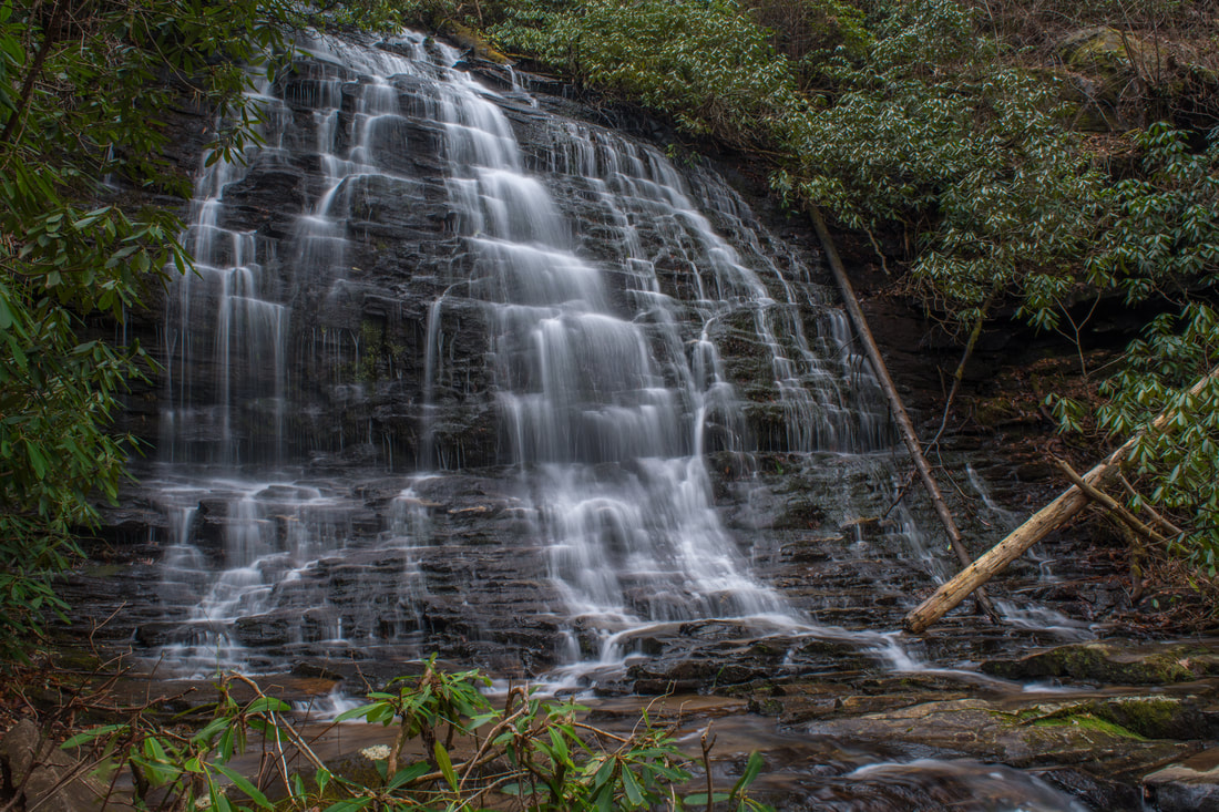
The Ellicott Rock Wilderness Area covers over 8000 acres across Georgia, South Carolina, and North Carolina. The wilderness's namesake is Ellicott Rock, located in the very heart of the wilderness at the point where all three states come together. From Burrells Ford, one can follow the Chattooga River Trail north into the wilderness all the way to Ellicott Rock and beyond. Besides passing Spoonauger Falls, the Chattooga River Trail affords numerous views of the river that it closely follows all the time. The other waterfall in the vicinity of Burrells Ford, King Creek Falls, is also easily-accessed and is among the most breathtaking waterfalls of the region. Intrepid waterfall chasers can also pick up the Bad Creek Trail from Ellicott Rock and make a challenging bushwhack to a secluded and pristine waterfall on Fowler Creek. This hike occurred on Saturday, January 27th, 2018. My plan was to first hike the Foothills Trail from Burrells Ford Campground to King Creek Falls. Then, I'd take the King Creek Trail and connect to the Chattooga River Trail. I'd follow the Chattooga River Trail north into the Ellicott Rock Wilderness all the way to Ellicott Rock, making the side trip to Spoonauger Falls along the way. From Ellicott Rock, I would follow the Bad Creek Trail and bushwhack down to Fowler Creek Falls. I would retrace most of my steps from Fowler Creek Falls, but when I would return to the vicinity of Spoonauger Falls, I would take the Foothills Trail straight to Burrells Ford Campground.
1 Comment
Foothills Trail: Musterground Road to Hilliard Falls to Horsepasture River, Salem, South Carolina6/18/2016 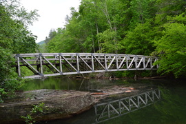
The 77-mile Foothills Trail straddles the North Carolina and South Carolina border for much of its trek through the Southern Blue Ridge Escarpment. One particular section between SC 130 and US 178 is nearly 30 miles long and is known for very limited road access. A very rough ATV road - used mainly by hunters - called Musterground Road, is open during hunting seasons. This road provides access to the Foothills Trail several miles east of the traditional Lower Whitewater Falls Trailhead. The section of the Foothills Trail east of Musterground Road visits Hilliard Falls, a tall waterfall on Bearcamp Creek, before using forest roads to wind through hills before reaching the Horsepasture River. This hike occurred on Saturday, April 30, 2016. My plan was to use an abandoned forest road to get to the Foothills Trail from Musterground Road. From there, i would follow the Foothills Trail to the Horsepasture River, with a side trip to Hilliard Falls. I would return the same way.
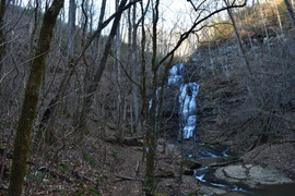 The Palmetto Trail is South Carolina's master trail, and when finished, it will extend across the entire state from the mountains to the coast. The trail starts off with a bang, and it's very first section is packed with interesting features, from a 60-foot waterfall to a historic site at Oconee Station to a breathtaking view from Tamassee Knob. Go in the winter, and you'll be treated to great views throughout the entire hike. This hike occurred on Saturday, December 19th, 2015. My plan was to first hike the Oconee Station Nature Trail, and then hike the Palmetto Trail's "Oconee Passage" from Oconee Station to Oconee State Park. Along the way, I would stop at Station Cove Falls. After reaching Oconee State Park, I would hike the Tamassee Knob Trail along a narrow ridge extending to a small summit with a fantastic vista.
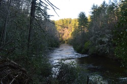
Big Bend Falls is one of the most powerful waterfalls in Upstate South Carolina. Located on the Chattooga Wild and Scenic River, the falls is one big mass of rapid whitewater, tumbling around 30 feet. To the east of the river, the Chattooga Ridge separates the main waterway from Cheohee Valley, which is a large area that lies at the base of the Cherokee Foothills. Several streams tumble down the steep eastern slopes of Chattooga Ridge, and a couple of these streams create several wonderful waterfalls that can be reached from the Winding Stairs Trail. This hike occurred on Saturday, April 4th, 2015. My plan was to hike the Winding Stairs Trail, the Big Bend Trail, and the Foothills Trail from the end of the Big Bend Trail to Cheohee Road. Since this isn't a loop and I didn't have a shuttle vehicle, I would finish with several miles of roadwalk on Cheohee Road.
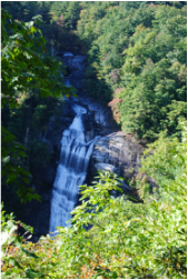 I have hiked a bit on the Foothills Trail, but in general I have underestimated it. This primer on the Foothills Trail in extreme upstate South Carolina is about as good as it can get while hiking - in fact, this is one of my favorite hikes not only this year, but in the past few years. The Whitewater River starts in the mountains near Cashiers, and grows on its way to Lake Jocassee. There are six waterfalls on the Whitewater River, but two waterfalls are the biggest ones, and more importantly, will take your breath. First, Upper Whitewater Falls is a gigantic double-tiered waterfall, claimed to be the highest waterfall east of the Mississippi River. Following this, the Whitewater River plunges with whitewater through the Whitewater River Gorge, exiting the gorge with another dramatic drop at Lower Whitewater Falls, into Lake Jocassee. This hike occurred on Saturday, October 11th, 2014. My plan was to take the Bad Creek Access Trail to the Foothills Trail, and first take the Foothills Trail east to the Lower Whitewater Falls Trail, and follow it to the Lower Whitewater Falls Overlook. Following this, I would backtrack to the Bad Creek Access Trail, and take the Foothills Trail northwest to Upper Whitewater Falls. After this, I would return the same way to the trailhead.
|
About MeMark Oleg Ozboyd Dear readers: I have invested a tremendous amount of time and effort in this website and the Georgia Waterfalls Database the past five years. All of the work that has gone in keeping these websites updated with my latest trip reports has almost been like a full-time job. This has not allowed me to pick up a paid job to save up money for college, and therefore, I I've had to take out loans. If you find the information on this website interesting, helpful, or time-saving, you can say "thanks" and help me out by clicking the button above and making a contribution. I will be very grateful for any amount of support you give, as all of it will apply toward my college tuition. Thank you!

Coming in 2022-2023?
Other Hiking WebsitesMiles HikedYear 1: 540.0 Miles
Year 2: 552.3 Miles Year 3: 518.4 Miles Year 4: 482.4 Miles Year 5: 259.9 Miles Archives
March 2021
Categories
All
|
 RSS Feed