HIKING THE APPALACHIANS AND BEYOND
  • Home
  • Trail Reports
    • Best Hikes
    • Hikes with Scenic Views
    • Hikes with Water Features
    • Alabama
    • Georgia
    • Florida
    • North Carolina
    • South Carolina
    • Tennessee
    • Vermont
    • Virginia
  • Map
  • Hike List
  • Testimonials
  • Resources
  • Contact Us
  • Southeast Nature Society
    • Our Team
  • Georgia Waterfalls Database

George Washington National Forest: Crabtree Falls Trail, Lovingston, Virginia

2/5/2017

0 Comments

 
Picture
Known as the tallest waterfall in Virginia, Crabtree Falls is a series of slides and waterfalls on Crabtree Creek, dropping approximately 1000 feet cumulatively. A hiking trail, equipped with well-constructed switchbacks and steps, provides easy access to all of the various drops of Crabtree Falls, each one unique in its own way. As a bonus, the large rock face at the top of the falls provides a great view into the Tye River Gorge. Just make sure to do this hike on a day when the crowds would likely be thinner than they were on my visit. This hike occurred on Sunday, November 27th, 2016. My plan was to hike the Crabtree Falls Trail out and back from VA 56 to the top of Crabtree Falls. ​This hike was the seventh and final of seven hikes that I did during a four-day Thanksgiving trip to the mountains of western Virginia.​


Read More
0 Comments

Jefferson National Forest: Roaring Run Falls Loop, Covington, Virginia

2/3/2017

0 Comments

 
Picture
The Roaring Run gorge in Virginia's Blue Ridge sports numerous scenic slides and cascades, on top of a spectacular 35-foot Roaring Run Falls. Several short nature trails provide easy access to this pristine location. The area also has an interesting iron ore mining history, which can be observed today in the form of the Roaring Run Furnace, an iconic sight  along this short loop hike in the vicinity of Roaring Run. This hike occurred on Saturday, November 26th, 2016. My plan was to hike the Roaring Run Falls Loop clockwise, by first following the Streamside Trail and then returning along the Woodland Trail, after hiking the side trail to Roaring Run Falls. This hike was the sixth of seven hikes that I did during a four-day Thanksgiving trip to the mountains of western Virginia.​


Read More
0 Comments

Appalachian Trail: Dragons Tooth Loop, New Castle, Virginia

2/1/2017

0 Comments

 
Picture
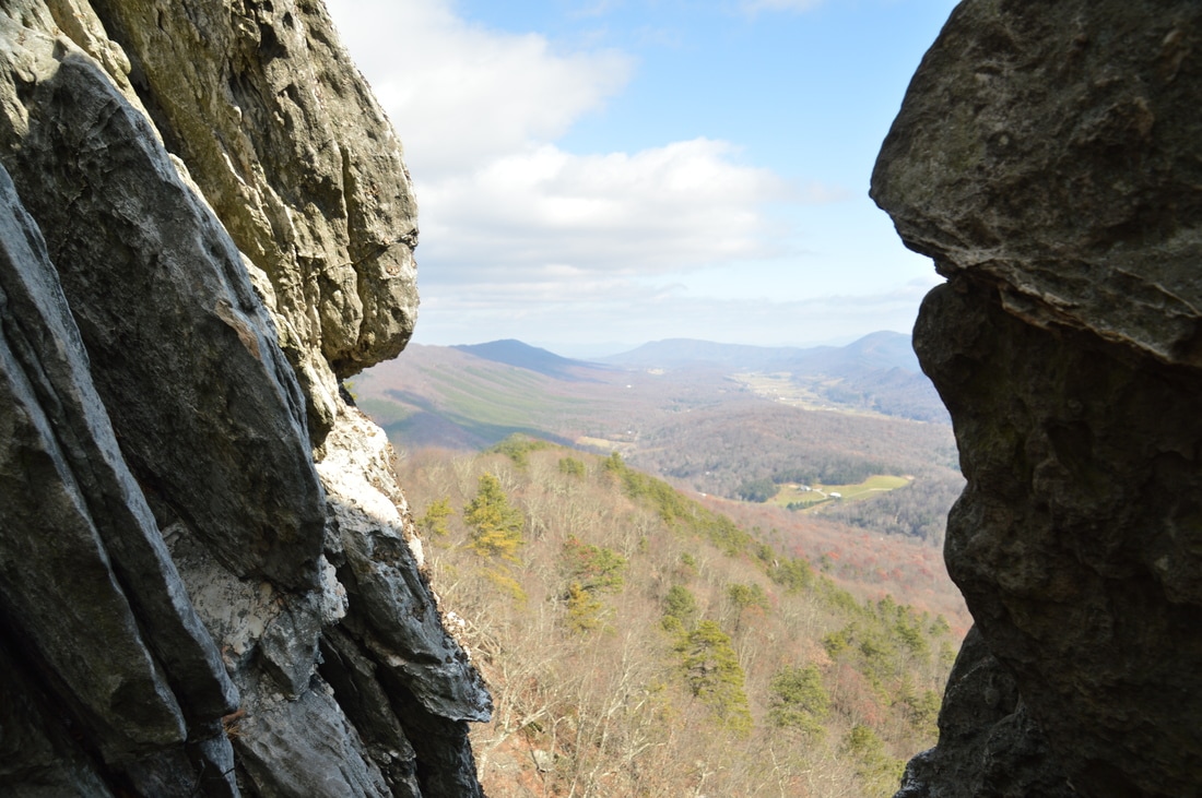
Virginia's "Triple Crown" hike involves a strenuous overnight backpack to three of the area's most famed vistas: McAfee Knob, Dragons Tooth, and Tinker Cliffs. All of these vistas are known for their sweeping long-range panoramas. While getting to all three of these overlooks in one hike requires serious stamina and overnight gear, hiking to any one of the three involves just a simple day hike. Out of the three, Dragons Tooth - as well as the hike to it - might be the most unusual. Dragons Tooth is a unique rock formation that towers like a spire at the southwest end of Cove Mountain. Those who are brave and skilled enough to climb to the top will be awarded with a stunning panorama that encompasses much of Catawba Valley. The hike to Dragons Tooth is no picnic either; this short stretch of the AT - dubbed as the most rugged stretch of the long-distance footpath south of Maine - involves a tricky and time-consuming rock scramble. This hike occurred on Saturday, November 26th, 2016. My plan was to hike the Dragons Tooth Trail to Lost Spectacles Gap, from where I would hike to Dragons Tooth out and back along the Appalachian Trail. After that, I would loop my return route by following the AT northeast to the Boy Scout Trail, concluding the hike along the Boy Scout Trail. This hike was the fifth of seven hikes that I did during a four-day Thanksgiving trip to the mountains of western Virginia.​


Read More
0 Comments

Blue Ridge Parkway: Sharp Top Mountain Trail, Buchanan, Virginia

1/30/2017

0 Comments

 
Picture
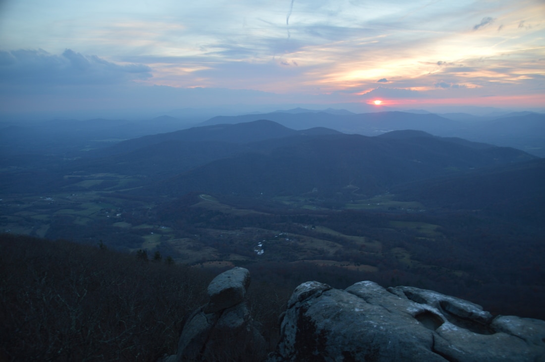
The Peaks of Otter - Sharp Top, Flat Top, and Harkening Hill - are three distinct mountains in the vicinity of the Blue Ridge Parkway. Several centuries ago, it was believed by Thomas Jefferson that the Peaks of Otter - along with the Blue Ridge Mountains in general - are the tallest peaks in the United States, but of course, this was later proved wrong, although not before stones were sampled from the Peaks of Otter and sent to be part of the Washington Monument. Hiking trails lead to each of the three peaks, and two of the three peaks provide excellent views. In fact, the rocky pinnacle at the summit of Sharp Top Mountain provides a 360-degree panorama that overlooks the Virginia Piedmont and the Blue Ridge Mountains that are scattered through the area. This hike occurred on Friday, November 25th, 2016. My plan was to hike the Sharp Top Mountain Trail out and back from Abbot Lake. I would make the short side trip to Buzzards Roost - a separate rock formation and viewpoint - along the way. ​This hike was the fourth of seven hikes that I did during a four-day Thanksgiving trip to the mountains of western Virginia.​


Read More
0 Comments

Jefferson National Forest: Apple Orchard Falls Trail and Cornelius Creek Trail, Buchanan, Virginia

1/24/2017

0 Comments

 
Picture
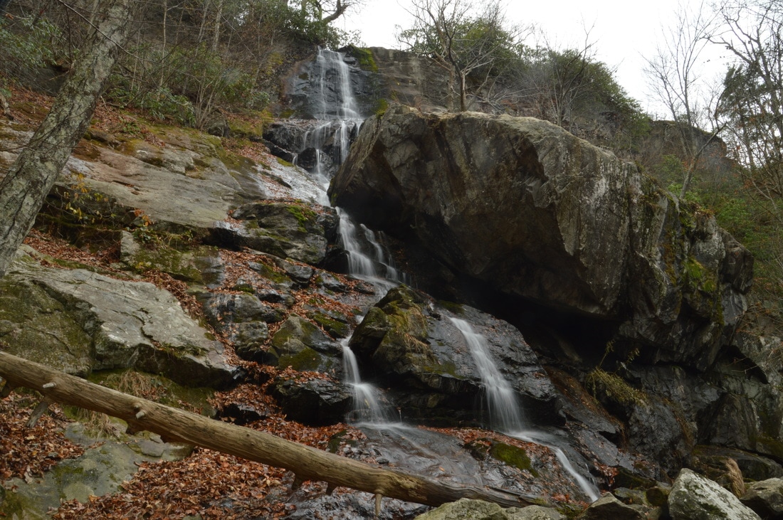
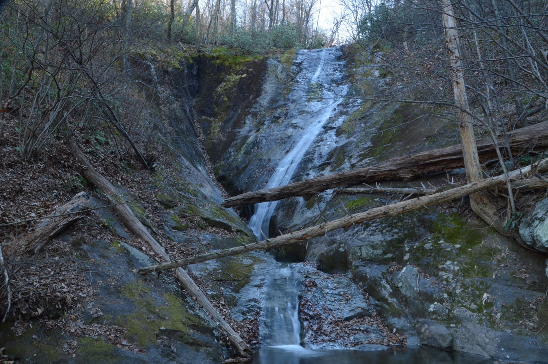
Virginia is known for its mountain vistas much more than for its streams and waterfalls. Interestingly, much of the terrain in the mountains of Virginia is not very supportive for large waterfalls, so when your Virginia hike takes you to a waterfall that is around two hundred feet high, it can be considered something special for sure. This hike visits Apple Orchard Falls. At 200 feet high, this waterfall is one of the highest in Virginia. Furthermore, the popular loop along North Creek, Apple Orchard Branch, and Cornelius Creek is one of the most beautiful stream hikes in George Washington and Jefferson National Forest and perhaps in all of Virginia. This hike occurred on Friday, November 25th, 2016. My plan was to hike the Apple Orchard Falls/Cornelius Creek Loop clockwise, by first following the Apple Orchard Falls Trail to and past Apple Orchard Falls. Then, I would hike the Cornelius Creek Spur Trail to the Cornelius Creek Trail, finishing the loop by taking the Cornelius Creek Trail back to the trailhead. This hike was the third of seven hikes that I did during a four-day Thanksgiving trip to the mountains of western Virginia.​


Read More
0 Comments

House Mountain Preserve: Big House Mountain Trail to Goat Point Overlook & Tabletop Rock and Little House Mountain Trail, Lexington, Virginia

1/19/2017

0 Comments

 
Picture
Driving through the vicinity of the town of Lexington, Virginia, one cannot fail to notice two twin summits rising up sharply to the northwest of town. The distant peaks tower out of the valley farmlands as you drive along US Route 11 near Lexington, and when you drive on I-64, the peaks are still there, although their character has changed as you see them from a different angle. The peaks are none other than Big and Little House Mountain, two mountains with outstanding 180-degree to 270-degree views. The House Mountain area was preserved by the Virginia Outdoors Foundation, and there are now established hiking trails to viewpoints on both mountains. In addition to the grand views that you'll see, you'll also get to visit a Big House Mountain boulder field that is home to a unique rock formation known as Tabletop Rock. This hike occurred on Thursday, November 24th, 2016. My plan was to hike to along a gated forest road to the saddle between Big House Mountain and Little House Mountain. Once there, I would hike out and back along the Big House Mountain Trail to Goat Point Overlook and Tabletop Rock on Big House Mountain. Then, I would return to the saddle and hike out and back to the vista on Little House Mountain. I would finish the hike by retracing my steps back down along the gated forest road. ​This hike was the second of seven hikes that I did during a four-day Thanksgiving trip to the mountains of western Virginia. Unfortunately, I got a late start and reached the Little House Mountain vistas after dark.

*Note: I am hoping to re-hike this trail in 2021 and update this trip report with better information and daylight pictures from Little House Mountain!

Read More
0 Comments

Natural Bridge State Park: Cedar Creek Trail to Natural Bridge and Lace Falls, Glasgow, Virginia

1/18/2017

2 Comments

 
Picture
The 215-foot natural bridge that is carved out by Cedar Creek is the centerpiece of Natural Bridge State Park, Virginia's newest state park. The Cedar Creek Trail travels through the Cedar Creek gorge for about a mile, passing a cave along the way, before terminating at Lace Falls, which is a beautiful multi-tiered 50-foot waterfall. Even though the incredible natural bridge is the main attraction on this hike, the trail visits several other features in this little known-area of Virginia. This hike occurred on Thursday, November 24th, 2016. My plan was to hike the Cedar Creek Trail out and back, passing under the Natural Bridge, past Saltpeter Cave, and reaching Lace Falls. This hike was the first of seven hikes that I did during a four-day Thanksgiving trip to the mountains of western Virginia.


Read More
2 Comments

Appalachian Trail: The Scales to Pine Mountain & Grayson Highlands State Park, Troutdale, Virginia

4/22/2014

5 Comments

 
Picture
The Highlands of Virginia have a unique environment, and some of the best hiking in the Southeast. Apart from a few places in North Carolina's Pisgah National Forest, I don't know of any other places like the Mount Rogers National Recreation Area in Virginia. While Mount Rogers itself is not the most interesting mountain, the Grayson Highlands, Wilburn Ridge, and Pine Mountain - all that sits off the flank of Mount Rogers - provide incredible long-range views. This hike occurred on Saturday, April 19, 2014. My plan was to take the Appalachian Trail northbound from The Scales to The Pine Mountain Trail. From  there, I planned hiking the Pine Mountain Trail to a point on the Appalachian Trail south of the original starting point, and follow the AT northbound to The Scales. I got to a late start in the late afternoon, due to the distance of the trail from my house, but I still thought I would finish it off shortly after dark. Not so fast, my friend. 


Read More
5 Comments

    About Me

    Mark Oleg Ozboyd
    I'm an avid outdoor explorer and a hobbyist landscape photographer. I'm 21 years old and have been hiking since 2011. Originally based out of Atlanta, Georgia, I started out by occasionally hiking short trails throughout well-known Georgia State Parks. During 2012 and 2013, I began to expand my trips into adjacent states, as well as into the wilder National Forest areas rather than just State Parks. Throughout the years that followed, as I slowly ran out of popular hiking trails in my area, I began to search for and hike in more seldom-visited areas. Today, you can find me out in the woods every weekend, whether it's on an official trail or bushwhacking through cross-country terrain without any paths. I now attend Washington & Lee University and am exploring Virginia and West Virginia. My other hobbies include chess, science, old music, and meteorology. I have 3 years of amateur weather forecasting experience, having studied a lot of meteorology basics over the years. I am also a student at European School of Music where I learned that music and nature have a lot in common. Listening to good music inspires me to capture nature's beauty on the camera in different aspects that also make me recall many beautiful music pieces that I've heard.​


    Dear readers: I have invested a tremendous amount of time and effort in this website and the Georgia Waterfalls Database the past five years. All of the work that has gone in keeping these websites updated with my latest trip reports has almost been like a full-time job. This has not allowed me to pick up a paid job to save up money for college, and therefore, I I've had to take out loans. If you find the information on this website interesting, helpful, or time-saving, you can say "thanks" and help me out by clicking the button above and making a contribution. I will be very grateful for any amount of support you give, as all of it will apply toward my college tuition. Thank you! 

    Enter your email address to subscribe for trail reports:

    Delivered by FeedBurner


    Picture
    Coming in 2022-2023?

    Other Hiking Websites

    DWHike's Adventures
    Florida's Natural Wonders
    Florida Trailblazer
    Meanderthals
    Mountain Images
    by Bernie Boyer

    North Carolina Waterfalls with
    ​Kevin Adams
    Take-a-Hike!
    Tennessee Landforms
    Waterfall Page
    Waterfall Adventurer
    Zach's Mild Adventures

    Miles Hiked

    Year 1: 540.0 Miles
    Year 2: 552.3 Miles
    ​Year 3: 518.4 Miles
    Year 4: 482.4 Miles
    Year 5: 259.9 Miles

    Archives

    March 2021
    February 2021
    January 2021
    November 2019
    October 2019
    September 2019
    August 2019
    July 2019
    June 2019
    February 2019
    January 2019
    December 2018
    November 2018
    October 2018
    August 2018
    July 2018
    June 2018
    May 2018
    April 2018
    March 2018
    February 2018
    January 2018
    December 2017
    November 2017
    October 2017
    September 2017
    August 2017
    July 2017
    June 2017
    May 2017
    April 2017
    March 2017
    February 2017
    January 2017
    December 2016
    November 2016
    October 2016
    September 2016
    August 2016
    June 2016
    May 2016
    April 2016
    March 2016
    January 2016
    December 2015
    November 2015
    October 2015
    September 2015
    August 2015
    July 2015
    June 2015
    May 2015
    April 2015
    March 2015
    February 2015
    January 2015
    December 2014
    November 2014
    October 2014
    September 2014
    August 2014
    July 2014
    June 2014
    May 2014
    April 2014
    March 2014
    February 2014

    Categories

    All
    Adel
    Adirondack Park
    Alabama
    Alfred A. Ring Park
    Allegheny Trail
    Amicalola Falls State Park
    Anniston Area
    Apalachicola Bluffs And Ravines Preserve
    Apalachicola National Forest
    Apalachicola/Port St. Joe Area
    Apopka
    Appalachian Trail
    Appling
    Art Loeb Trail
    Aska Trail System
    Bakersville
    Balm-Boyette Scrub Preserve
    Balsam Lake Recreation Area
    Bankhead National Forest
    Bartow County Parks
    Bartram Trail
    Basinger
    Beersheba Springs
    Benton
    Benton Mackaye Trail
    Berry College Trail System
    Best Hike
    Big South Fork National Recreation Area
    Black Bear Wilderness
    Black Rock Mountain State Park
    Blairsville
    Blakely
    Blood Mountain Wilderness
    Blowing Rock
    Blue Ridge
    Blue Ridge Parkway
    Boone
    Bradenton
    Bradenton Beach
    Brasstown Bald
    Brasstown Wilderness
    Brevard
    Bryson City
    Buchanan
    Bucks Pocket State Park
    Bulow Creek State Park
    Bulow Plantation Ruins State Park
    Caesars Head State Park
    Caladesi Island State Park
    Calhoun
    Camel's Hump State Park
    Cashiers
    Caspersen Beach Park
    Catfish Creek State Park
    Caves
    CC Putnam State Forest
    Cedar Point Environmental Park
    Chatsworth
    Chattahoochee National Forest
    Chattanooga
    Chattanooga Valley
    Chattooga National Wild And Scenic River
    Cheaha Wilderness
    Cherohala Skyway
    Cherokee
    Cherokee National Forest
    Chiefland Area
    Chillhowee Recreation Area
    Chipley
    Chunky Gal Trail
    Circle B Bar Reserve
    Citico Creek Wilderness
    Citrus Wildlife Management Area
    Clarkesville
    Clayton
    Cleevland
    Cleveland
    Cloudland Canyon State Park
    Cohutta Wilderness
    Collier-Seminole State Park
    Cordele
    Cornelia
    Covington
    Crestview Area
    Crew-land-and-water-trust
    Cullowhee
    Cumberland Trail
    Dahlonega
    Dalton
    Dawson Forest Wildlife Management Area
    Dawsonville
    Dayton
    De Soto National Memorial
    DeSoto State Park
    Dillard
    Double Springs
    Ducktown
    Duncan Ridge Trail
    Dunlap
    Eagle's Rest Park
    Eastpoint
    Econfina Creek Wildife Management Area
    Eglin Air Force Base
    Elizabethton
    Elkins
    Elk Knob Game Lands
    Elk Park
    Ellicott Rock Wilderness
    Ellijay
    Emerson Point Preserve
    Englewood Area
    Enota Retreat
    Erwin
    Falling Waters State Park
    Fayetteville
    Fires Creek Recreation Area
    Fire Tower
    Flint River
    Florence Area
    Florida
    Florida Caverns State Park
    Florida Trail
    Foothills Trail
    Fort Mountain State Park
    Fort Myers Area
    Fort Payne
    Fort Payne Area
    Fort Yargo State Park
    Franklin
    Franklin Delano Roosevelt State Park
    Franklin-Marion State Forest
    Frozen Head State Park
    Gainesville
    Gainesville Area
    Gatlinburg
    George Washington National Forest
    Georgia
    Georgia Veterans Memorial State Park
    Glasgow
    Gorges State Park
    Grandfather Mountain State Park
    Great Smoky Mountains National Park
    Greeneville
    Green River Game Lands
    Gruetli-Laager
    Grundy Forest State Natural Area
    GTM Reserve
    Guana River Wildlife Management Area
    Hayesville
    Helen
    Hiawassee
    High Falls State Park
    Highlands
    Highlands Scenic Highway
    Hillsborough River State Park
    Hinson Conservation & Recreation Area
    Historic Sites
    Honeymoon Island State Park
    Hot Springs
    Huntington
    Inverness Area
    Jackson
    Jasper
    Jefferson National Forest
    Joan M. Durante Park
    Jonathan Dickinson State Park
    Jones Gap State Park
    Joyce Kilmer Slickrock Wilderness
    Joyce Kilmer - Slickrock Wilderness
    Juniper Prairie Wilderness
    Kelly Park
    Keown Falls Recreation Area
    Kolomoki Mounds State Park
    LaFayette
    Lake City Area
    Lake George Wild Forest
    Lake June-in-Winter State Park
    Lakeland Area
    Lake Placid
    Lake Russell Wildlife Management Area
    Lake Wales Ridge State Forest
    Laurel Fork North Wilderness
    Leffis Key Preserve
    Leon Sinks Geological Area
    Lexington
    Lineville
    Linville
    Linville Gorge Wilderness
    Lithia Springs
    Little Frog Wilderness
    Little Manatee River State Park
    Little River Canyon National Preserve
    Longboat Key
    Long Trail
    Lookout Mountain
    Lookout Mountain Battlefield
    Lovingston
    Lula Lake Land Trust
    Lumpkin
    Maggie Valley
    Manatee Springs State Park
    Marianna Area
    Mark Trail Wilderness
    Marlinton
    Mccaysville
    McMinville
    Mentone
    Middlesex
    Mistletoe State Park
    Monongahela National Forest
    Montreat
    Mountain Bridge Wilderness Area
    Mountain City
    Mountains To Sea Trail
    Mountains-to-Sea Trail
    Mount Rogers National Recreation Area
    Myakka River State Park
    Myron B. Hodge City Park
    Nantahala National Forest
    Naples
    Naples Area
    Natural Bridge State Park
    Neal Preserve
    New Castle
    Newport
    New River Gorge National Park
    New York
    North Carolina
    Ocala Area
    Ocala National Forest
    Ocean-to-Lake Trail
    Oconee State Park
    Oconee Station Historic Site
    Okaloacoochee Slough State Forest
    Oldsmar
    Oneida
    Orlando Area
    Ormond Beach
    Oscar Scherer State Park
    Oxford
    Palatka
    Palmetto Trail
    Panama City Area
    Panthertown Valley
    Parrish
    Paynes Creek Historic State Park
    Peaks Of Otter Recreation Area
    Pigeon Crockford Mountain Wildlife Management Area
    Pigeon-Crockford Mountain Wildlife Management Area
    Pigeon-Crockford Wildlife Management Area
    Pine Mountain
    Pinhoti Trail
    Pinnacle Park
    Pisgah Civitan Park
    Pisgah National Forest
    Pittman Center
    Pond Mountain Wilderness
    Ponds/Lakes
    Prentice Cooper State Forest
    Providence Canyon State Park
    Pumpkintown
    Quick Point Nature Preserve
    Raven Cliffs Wilderness
    Reed Bingham State Park
    Reliance
    Rice Creek Conservation Area
    Riverview Pointe Preserve
    Robbinsville
    Robinson Preserve
    Rock Creek Gorge Scenic Area
    Rock Island State Park
    Rome
    Rosman
    Sale Creek
    Salem
    Salt Springs
    Saluda
    Santa Rosa Beach
    Sarasota
    Sarasota Area
    Savage Gulf State Natural Area
    Scenic Views
    Scottsboro Area
    Sebring Area
    Sewanee
    Sheltowee Trace Trail
    Shining Rock Wilderness
    Signal Mountain
    Sipsey Wilderness
    Sky Valley
    Smithgall Woods State Park
    Snowbird Backcountry Area
    Soddy Daisy
    Soddy-Daisy
    Sopchoppy
    South Carolina
    South Cumberland State Park
    Southeastern Cave Conservancy
    Southern Nantahala Wilderness
    Sparta
    Sprewell Bluff Park
    Spring City
    Spring Hill
    Springs
    Spruce Pine
    Standing Indian Backcountry Area
    St. Augustine
    St. George Island State Park
    St. Joseph Bay State Buffer Preserve
    St. Marks Area
    St. Marks National Wildlife Refuge
    Stone Mountain
    Stone Mountain Park
    Suches
    Sumatra
    Sumter National Forest
    Suwannee River
    Swallow Creek Wildlife Management Area
    Sweetwater Creek State Park
    Sylva
    Talladega National Forest
    Tallahassee Area
    Tallulah Falls
    Tallulah Gorge State Park
    Tampa Bay Area
    Tate City
    Tate's Hell State Forest
    Tea Creek Wildlife Management Area
    Tellico Plains
    Tennessee
    Thomaston
    Toccoa
    Topsail Hill State Park
    Torreya State Park
    Townsend
    Tracy City
    Tray Mountain Wilderness
    Trenton
    Triple Creek Preserve
    Troutdale
    Unaka Mountain Wilderness
    Upper Tampa Bay County Park
    Venice
    Vermont
    Virgin Falls State Natural Area
    Virginia
    Virginia Outdoors Foundation
    Vogel State Park
    Wakulla Springs State Park
    Waleska
    Walhalla
    Wartburg
    Water Features
    Waynesville
    Weedon Island Preserve
    Weeki Wachee Preserve
    Wekiwa Springs State Park
    West Palm Beach Area
    West Virginia
    Whitehall
    White Springs
    Winder
    Withlacoochee State Forest
    Young Harris

    RSS Feed

TRAIL REPORTS

Hikes in Alabama
​Hikes in Florida
Hikes in Georgia
Hikes in North Carolina
Hikes in South Carolina
Hikes in Tennessee
Hikes in Virginia

Hiking Resources

Alabama Resources
​
Florida Resources
Georgia Resources
North Carolina Resources
​South Carolina Resources
​
Tennessee Resources

Other

Contact
Map of Hikes
Alphabetical List of Hikes
Southeast Nature Society
© COPYRIGHT 2014-2018
​ALL RIGHTS RESERVED.
Important: I disclaim any responsibility for any damage or personal injury that may occur as a result of the activities and information found on this website. All outdoor activities, especially off-trail hiking, are done at your own risk. Never hike or head into that area that may be above your fitness or experience level.
  • Home
  • Trail Reports
    • Best Hikes
    • Hikes with Scenic Views
    • Hikes with Water Features
    • Alabama
    • Georgia
    • Florida
    • North Carolina
    • South Carolina
    • Tennessee
    • Vermont
    • Virginia
  • Map
  • Hike List
  • Testimonials
  • Resources
  • Contact Us
  • Southeast Nature Society
    • Our Team
  • Georgia Waterfalls Database