
When you're looking for outdoor recreational opportunities near the busy city of Atlanta, chances are you won't find much - but your best shot would be to take a look at nearby state parks, such as Sweetwater Creek State Park, Panola Mountain State Park, and the one this article is about: Fort Yargo State Park. While this state park has neither the solitude nor the remoteness of a wilderness area, you will still find a nice, easy day hike that is doable as an after-work hike or a short weekend outing. This hike occurred on Saturday, May 16th, 2015. My plan was to hike the loop trail around Fort Yargo Lake counter-clockwise, and also to hike the Winder Connector Trail roundtrip (I never found the trailhead for it though). Most of the loop trail was going to be open to both bikers and hikers, although a small section was going to be hiking only.
3 Comments
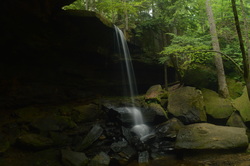
The Sipsey Fork of the Black Warrior River is Alabama's only federally designated Wild and Scenic River. The small, sandy waterway's clean waters flow through a narrow gorge in the northwestern section of Bankhead National Forest in western Alabama. While the river itself may be a bit tame, you'll encounter several different waterfalls on its tributaries, and some of the rock outcroppings - most importantly the Tunnel of Borden - are astounding. This hike occurred on Saturday, May 9th, 2015. My plan was to start my hike at the Randolph Trailhead. I would combine several well-known hikes with more secluded sections of trail. I would first take Randolph Trail to the Sipsey Fork. Then, I would ford the Sipsey Fork and take the Sipsey River Trail downstream to Borden Creek. Following a ford of Borden Creek, I would take the Borden Creek Trail upstream to the Borden Creek Trailhead. Next, I would take the Bunyan Hill Trail to Bee Ridge Trail, and the Bee Ridge Trail back down to the Sipsey River Trail, with a short diversion along the way to East Bee Branch Falls and The Big Tree on the East Bee Branch Trail. Once I got back to the river, I would take the Sipsey River Trail upstream, ford the river one more time, and break the rim, reaching the Rippey Trail. I would finish by following the Rippey Trail back to the trailhead.

Mill Shoals Creek, flowing off the eastern fringe of Talladega Mountain, is home to two of the few water features in the Cheaha Wilderness part of Talladega National Forest. Once you cruise past the two waterfalls, start on a clockwise loop that will take you through thickets of mountain laurel, through boulder fields, and pass grand rock cliffs, before reaching the grand destination - a beautiful vista on a rock outcrop which provides unobstructed views westward into the heart of Alabama. Finish the loop with some boulder field hiking and back down Mill Shoals Creek. This hike occurred on Sunday, April 24th, 2015. My plan was to hike the Nubbin Creek Trail to its terminus at the Odum Scout Trail. From here on, I'd turn right and take the Odum Scout Trail to its terminus at the Pinhoti Trail. Next, I would turn right and take the Pinhoti Trail to the Cave Creek Connector. Then, I would turn right onto Cave Creek Connector, connect to Cave Creek Trail, and turn right to follow the Cave Creek Trail to its terminus back at the Nubbin Creek Trail. I would finish the hike by returning the way I came on Nubbin Creek Trail.
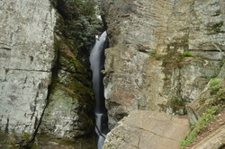
Raven Cliff Falls is one of the most unique waterfalls in Georgia. Dodd Creek falls 80 feet through a narrow crevice in a large cliff, followed by a 20-foot cascade before becoming peaceful. Dodd Creek also makes several more significant drops, as it grows in size, before reaching the main show where it joins Davis Creek to become Dukes Creek - the 200-foot Dukes Creek Falls - although that one isn't quite on this hike. The 5-mile trail to Raven Cliff Falls is an excellent way to introduce yourself to hiking, as it's a good first hike. For the more experienced, a slim route, along a rock jumble and up a root ladder leads to the top of the cliff which is home to Raven Cliff Falls. This hike occurred on Saturday, April 18, 2015. My plan was to hike the Raven Cliff Falls Trail out and back from the trailhead.
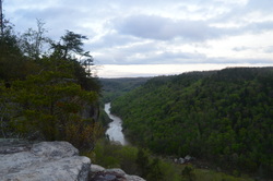
The Big South Fork of the Cumberland River is one of the biggest to bisect the Cumberland Plateau. It flows through a rugged gorge in extreme northern Tennessee and then into Kentucky, before flowing into the Cumberland River near Somerset. This hike is one of the best for your first visit to the area, as it encompasses the shear beauty of the gorge and surroundings, culminating in one of the most beautiful overlooks I have ever encountered anywhere - Angel Falls Overlook - making this one of the best hikes in Tennessee. This hike occurred on Thursday, April 16, 2015. My plan was to start my hike at the East Rim Trailhead. I'd first see East Rim Overlook and do the short hike to Sunset Overlook. And then, I would do the Leatherwood Loop and follow the John Muir Trail to Angel Falls Overlook and back.
|
About MeMark Oleg Ozboyd Dear readers: I have invested a tremendous amount of time and effort in this website and the Georgia Waterfalls Database the past five years. All of the work that has gone in keeping these websites updated with my latest trip reports has almost been like a full-time job. This has not allowed me to pick up a paid job to save up money for college, and therefore, I I've had to take out loans. If you find the information on this website interesting, helpful, or time-saving, you can say "thanks" and help me out by clicking the button above and making a contribution. I will be very grateful for any amount of support you give, as all of it will apply toward my college tuition. Thank you!
Coming in 2022-2023?
Other Hiking WebsitesMiles HikedYear 1: 540.0 Miles
Year 2: 552.3 Miles Year 3: 518.4 Miles Year 4: 482.4 Miles Year 5: 259.9 Miles Archives
March 2021
Categories
All
|

 RSS Feed