
There's the touristy side of the Horsepasture River. There's the monster Rainbow Falls and its sidekicks, Stairway Falls, Turtleback Falls, and Drift Falls, all some of Gorges State Park's most popular and highly-regarded destinations. And then there's Windy Falls... the Horsepasture's truly wild side, tackled only by the most hardcore waterfallers and rock climbers. The Horsepasture's other waterfalls pale in comparison in the mighty shadow of Windy Falls, which crashes over 200 vertical feet through a conglomerate of boulders the sizes of two-story houses and slanted cliffs the sizes of small football fields. Those who reach this monster waterfall's base will be rewarded with a first-rate view of raw, breathtaking power, dwarfed by the even more majestic rocky surroundings. Yet reaching the base is an adventure not to be taken lightly, involving two rock scrambles with ropes and a squeeze through a keyhole perfect for getting stuck if you're larger than the average person. Gorges State Park neither sanctions nor recommends the trip to Windy Falls, and neither do I. Only people with substantial experience in cross-country rock scrambling with ropes must attempt to reach the base; those who don't could get injured or even fall to their deaths. Proceed at your own risk. This hike occurred on Saturday, September 8th, 2018. My plan was to hike out and back to the base of Windy Falls using a steep, unofficial trail from Chestnut Mountain Road concluding in a series of technical and potentially dangerous rock scrambles.
1 Comment
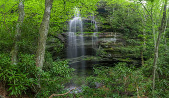
Just off NC 281 is a lesser-known entrance to the backcountry of Panthertown Valley: the West Fork Way trailhead. The unofficial West Fork Way ascends through the West Fork French Broad River watershed for several miles, passing the extremely steep access trail to three spectacular waterfalls: Rhapsodie Falls, Dismal Falls, and Lower Dismal Falls. West Fork Way then connects to another unofficial trail on the fringes of Panthertown Valley called the Shelton-Pisgah Trail, which follows a seldom-hiked pathway along the ridge of Shelton-Pisgah Mountain to Cold Mountain. A cliff on the west side of Cold Mountain, nicknamed the High Bethel View features an outstanding vista of Panthertown Valley spread out to the west - arguably the best of the valley's five views. This hike occurred on Saturday, May 12th, 2018. My plan was to hike West Fork Way and Shelton-Pisgah Trail out and back to Cold Mountain. Along the way, I would take the side trails to Rhapsodie Falls, Dismal Falls, and Lower Dismal Falls. I would also stop by two other small falls - Aunt Sally's Falls and Lower Rhapsodie Falls.
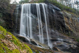
Adjacent to the popular Panthertown Valley hiking area lies a much-lesser-visited valley: the Flat Creek watershed. This remote area is home to two very scenic waterfalls on Flat Creek. The massive Flat Creek Falls is among the most spectacular and stunning waterfalls in the Southeast. Dropping as much as 200 feet in a series of powerful cascades, slides, and a huge free-fall, Flat Creek Falls evokes a sense of amazement among anyone who finds their way to its base. Flat Creek features a much smaller but equally notable waterfall as well: Nellie's Falls. Located a couple of miles upstream, Nellie's Falls is a very picturesque double-drop waterfall. The lush, tropical-like setting of Nellie's Falls - the long moss-covered rock slabs near the base of the falls, in particular - help to make it a very scenic destination. Both waterfalls can be seen in the same hike, which utilizes mostly old roadbeds and unmaintained paths. Although the majority of the hike to both falls is fairly easy, getting to the base of Flat Creek Falls involves a steep off-trail descent. This hike occurred on Saturday, April 7th, 2018. My plan was to hike out and back from the end of Rock Bridge Road first to Nellie's and then to Flat Creek Falls.
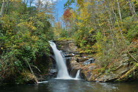
Southwest North Carolina's Wolf Creek sure is a potent stream with the six major waterfalls it is home to. The tallest and best-known waterfall on the creek is Wolf Creek Falls aka Paradise Falls below Wolf Creek Lake. But higher up on Wolf Creek is a set of four breathtaking pristine waterfalls clustered close together near Balsam Lake. The series of falls culminates with Lauren Falls, a spectacular near free-fall with a deep pool surrounded by beautiful water-sculpted rock outcrops. The hike to these waterfalls, especially Patricia Falls and Lauren Falls, is quite difficult as it involves a lot of off-trail scrambling, but less experienced hikers have the choice to hike just to the first waterfall, Balsam Falls, which is considerably easier to reach with only minimal scrambling. Along the way, visitors will be treated to many gorgeous views of Balsam Lake along the Mallonee Trail. This hike occurred on Saturday, October 14th, 2017. My plan was to hike to the Mallonee Trail along Balsam Lake from Balsam Lake Recreation Area to Balsam Lake Dam, from where I would follow faint paths to Balsam Falls, Lower Balsam Falls, Patricia Falls, and Lauren Falls. I would return the same way.
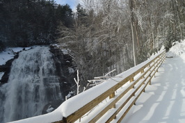 Gorges State Park is North Carolina's newest and westernmost state park, located in the area where Georgia, South Carolina, and North Carolina meet. The crown jewel of this still-developing park is the Rainbow Falls Trail, a normally easy hike that leads you to four spectacular waterfalls in the Horsepasture River gorge. On a day with 14-18 inches of fresh snow on the ground, however, the hike may not be so easy. This hike occurred on Saturday, January 23rd, 2016. My plan was to hike the Rainbow Falls Trail in the park out and back, visiting Stairstep Falls, Rainbow Falls, Turtleback Falls, and Drift Falls. I also planned to visit Raymond Fisher Pond and perhaps try some of the other short trails in the park. However, my plans were altered due to a heavy snowstorm that hit the region on the day before. All of western North Carolina got upwards of a half-foot of snow, with some areas (such as Gorges State Park) receiving as much as 18 inches. This caused Gorges State Park to be closed, and when I did this hike, I hiked the entrance road which added several miles more to my hike. Additionally, I was the first person to hike the Rainbow Falls Trail after snow, and with there being no previous footprints, it was a very slow and difficult hike. Thus, I was only able to hike the Rainbow Falls Trail to Rainbow Falls, Turtleback Falls, and Drift Falls. |
About MeMark Oleg Ozboyd Dear readers: I have invested a tremendous amount of time and effort in this website and the Georgia Waterfalls Database the past five years. All of the work that has gone in keeping these websites updated with my latest trip reports has almost been like a full-time job. This has not allowed me to pick up a paid job to save up money for college, and therefore, I I've had to take out loans. If you find the information on this website interesting, helpful, or time-saving, you can say "thanks" and help me out by clicking the button above and making a contribution. I will be very grateful for any amount of support you give, as all of it will apply toward my college tuition. Thank you!
Coming in 2022-2023?
Other Hiking WebsitesMiles HikedYear 1: 540.0 Miles
Year 2: 552.3 Miles Year 3: 518.4 Miles Year 4: 482.4 Miles Year 5: 259.9 Miles Archives
March 2021
Categories
All
|

 RSS Feed