HIKING THE APPALACHIANS AND BEYOND
  • Home
  • Trail Reports
    • Best Hikes
    • Hikes with Scenic Views
    • Hikes with Water Features
    • Alabama
    • Georgia
    • Florida
    • North Carolina
    • South Carolina
    • Tennessee
    • Vermont
    • Virginia
  • Map
  • Hike List
  • Testimonials
  • Resources
  • Contact Us
  • Southeast Nature Society
    • Our Team
  • Georgia Waterfalls Database

Bucks Pocket State Park: Point Rock Trail, Section, Alabama

5/11/2018

0 Comments

 
Picture
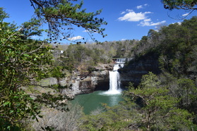
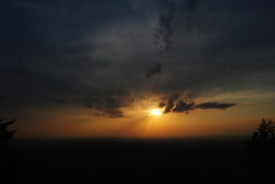
Protecting a small gulch on the east side of Lake Guntersville, Bucks Pocket State Park is one of Alabama's most underrated state parks. Bucks Pocket features a small slice of beautiful, wild scenery typical to the Cumberland Plateau. Two scenic, cliff-lined gorges are found in the park: those of Little Sauty Creek and South Sauty Creek. The park's best-known trail, the Point Rock Trail, follows Little Sauty Creek through numerous mossy boulder fields and woods that feature an abundance of wildflowers in spring, passing a small but very scenic waterfall on the stream. The Point Rock Trail then ascends to the rim of the gorge and ends at its namesake rock outcrop, which features panoramic views from a point on the rim high above the confluence of Little Sauty Creek and South Sauty Creek. This hike occurred on Saturday, March 17th, 2018. My plan was to hike the Point Rock Trail out and back to Point Rock from the Bucks Pocket Campground. 


Read More
0 Comments

Pisgah Civitan Park: Pisgah Gorge Trail and Little Bryant Creek Waterfalls, Pisgah, Alabama

5/9/2018

1 Comment

 
Picture
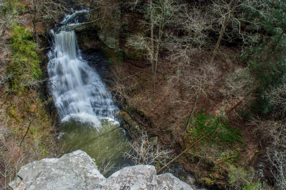
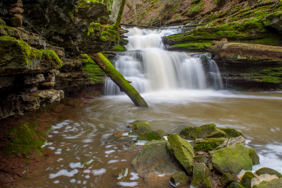
Inside the city limits of the quaint town of Pisgah in northeast Alabama is one of the area's most under-appreciated pieces of public land: the Pisgah Civitan Park. This small community park protects a section of the course of Little Bryant Creek through Pisgah Gorge that features three notable waterfalls - two of which are significant - and an extraordinary natural bridge. An easy trail follows the rim of the gorge, accessing several clifftop perches with sweeping birds-eye views of the gorge and its waterfalls. More adventurous hikers will find a faint, rugged pathway that drops into the gorge, accessing the base of Middle Little Bryant Creek Falls and the natural bridge. Pisgah Gorge features a sampling of some of Northeast Alabama's finest natural scenery and must not be missed! This hike occurred on Saturday, March 17th, 2018. My plan was to first hike the rim trail out and back to views of Upper Little Bryant Creek Falls, Middle Little Bryant Creek Falls, and the Pisgah Gorge downstream. I would then descend the trail into the gorge to get up-close and personal with the middle falls and the arch. In addition, I would check out a side trail leading to an old mill site at the top of the upper falls. 


Read More
1 Comment

Southeastern Cave Conservancy: Stephens Gap Cave & Falls Trail, Scottsboro, Alabama

5/7/2018

0 Comments

 
Picture
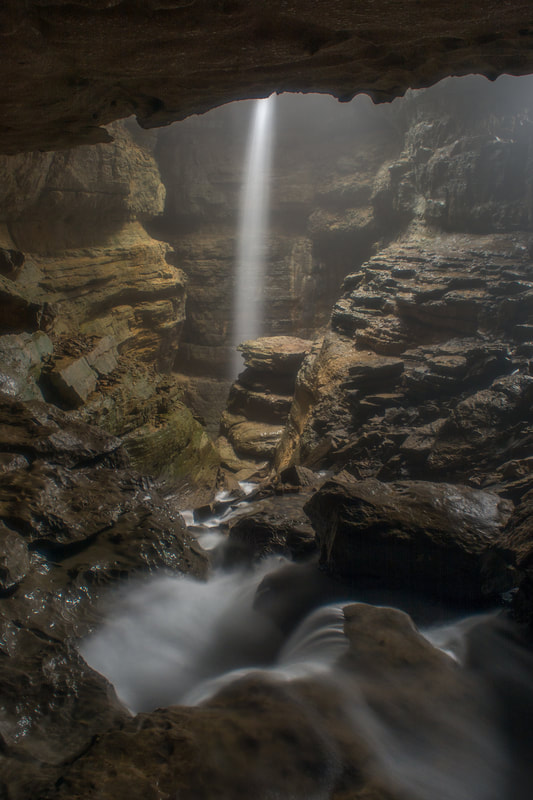
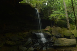
Have you ever wanted to see both a waterfall and a cave on one hike? Then Stephens Gap Callahan Cave Preserve is the place for you. Not only do you get to see a waterfall and a wild cave here, but they are both in the same place! The gloomy cavernous space of Stephens Gap Cave features an incredible waterfall that shoots out of an opening in the cave and free-falls over 100 feet into the pit underneath. What's more: you don't need any caving experience at all to get into the Stephens Gap Cave's primary chamber and to view the waterfall. As long as you're capable of scrambling steeply down a boulder field into the cave and don't mind getting dirty, you can easily tour this stunning natural feature. The short hike to the cave is pretty in its own right, especially in spring, when a mosaic of new, bright green ferns is seen among the area's boulder fields and rock outcrops. Access to Stephens Gap Cave is exclusively by a permit system. Only 25 people are allowed to visit the cave on any given day, so it's best to register for your free online permit from the Southeastern Cave Conservancy in advance to ensure your access to the cave. For the best experience, visit the cave after rainfall or during a wetter period - that's when the falls is the most impressive. This hike occurred on Saturday, March 17th, 2018. My plan was to hike out and back to Stephens Gap Cave via the access trail from County Road 30. 


Read More
0 Comments

DeSoto State Park: Laurel Falls Trail, CCC Quarry Trail, and DeSoto Scout Trail (CCC Trail Shelter to Lodge), Fort Payne, Alabama

6/3/2016

0 Comments

 
Picture
As one of Alabama's first state parks, DeSoto State Park was developed by the Civilian Conservation Corps during the 1930s, and much of their work can still be seen throughout the park today. Located on Lookout Mountain, the park is positioned on the west side of the West Fork of the Little River, conveniently close to the town of Fort Payne. A network of hiking trails visits as many as five waterfalls on tributaries of West Fork Little River. You will also see some views of the Little River gorge and some of the CCC's work on this moderate mountaintop hike. This hike occurred on Saturday, April 2nd, 2016. After completing a short hike to nearby De Soto Falls, I drove down to DeSoto State Park with a plan to make a loop out of several of the park's trail. First, I would take the Talmadge Butler Boardwalk to Azalea Cascade. Then, I would take the Azalea Cascade Trail to the Laurel Falls Trail. I would follow the Laurel Falls Trail to the Lost Falls Trailhead, making sure to make the side trips to Laurel Falls and Lost Falls. After the Lost Falls Trailhead, I would continue on a mountain bike trail that would take me past the CCC Museum and to the CCC Quarry. From the CCC Quarry, I would follow the CCC Quarry Trail to its terminus near the DeSoto State Park Visitor Center. After this, I would cross the park's Picnic and Play Area and follow an access trail to the DeSoto Scout Trail. I would follow the DST north for a little bit to the CCC Trail Shelter and views of the Little River, before turning south and finishing the hike at the park's lodge, passing Indian Falls and Lodge Falls in the meantime. A bit of roadwalk would be necessary to return back to the parking area. 


Read More
0 Comments

De Soto Falls Trail System, Mentone, Alabama

5/31/2016

13 Comments

 
Picture
Alabama's Little River is one of the few rivers in the United States that flows along a mountaintop. The headwaters of both the West Fork and East Fork of the Little River are in northwest Georgia on Lookout Mountain. Both forks of the river continue flowing along Lookout Mountain into Alabama, gradually carving out their own gorges on the mountain, before merging together and entering the Little River Canyon. Upon the end of Little River Canyon, the Little River flows into the Coosa River. One of the major landmarks on the West Fork of the Little River is De Soto Falls - an impressive waterfall that drops more than 100 feet into a rock amphitheater. The official view of the falls is from a rock outcrop on the side of the falls at the end of Desoto Falls Road. However, many people are not aware of an unofficial trail system that leads to the base of the falls. This hike occurred on Saturday, April 2nd, 2016. My plan was to take the unofficial trail from Desoto Falls Road past Icebox Cave to the base of De Soto Falls. Then, I would return to the road and take another unofficial trail to a view that would take in all of De Soto Falls and its basin. 


Read More
13 Comments

Sipsey Wilderness: Randolph Trail, Loop via Sipsey River Trail, Borden Creek Trail, Bunyan Hill Trail, Bee Ridge Trail, & Rippey Trail, Double Springs, Alabama

5/27/2015

2 Comments

 
Picture
The Sipsey Fork of the Black Warrior River is Alabama's only federally designated Wild and Scenic River. The small, sandy waterway's clean waters flow through a narrow gorge in the northwestern section of Bankhead National Forest in western Alabama. While the river itself may be a bit tame, you'll encounter several different waterfalls on its tributaries, and some of the rock outcroppings - most importantly the Tunnel of Borden - are astounding. This hike occurred on Saturday, May 9th, 2015. My plan was to start my hike at the Randolph Trailhead. I would combine several well-known hikes with more secluded sections of trail.  I would first take Randolph Trail to the Sipsey Fork. Then, I would ford the Sipsey Fork and take the Sipsey River Trail downstream to Borden Creek. Following a ford of Borden Creek, I would take the Borden Creek Trail upstream to the Borden Creek Trailhead. Next, I would take the Bunyan Hill Trail to Bee Ridge Trail, and the Bee Ridge Trail back down to the Sipsey River Trail, with a short diversion along the way to East Bee Branch Falls and The Big Tree on the East Bee Branch Trail. Once I got back to the river, I would take the Sipsey River Trail upstream, ford the river one more time, and break the rim, reaching the Rippey Trail. I would finish by following the Rippey Trail back to the trailhead.


Read More
2 Comments

Cheaha Wilderness: Nubbin Creek Trail and Loop via Pinhoti Trail, Lineville, Alabama

5/14/2015

0 Comments

 
Picture
Mill Shoals Creek, flowing off the eastern fringe of Talladega Mountain, is home to two of the few water features in the Cheaha Wilderness part of Talladega National Forest. Once you cruise past the two waterfalls, start on a clockwise loop that will take you through thickets of mountain laurel, through boulder fields, and pass grand rock cliffs, before reaching the grand destination - a beautiful vista on a rock outcrop which provides unobstructed views westward into the heart of Alabama. Finish the loop with some boulder field hiking and back down Mill Shoals Creek. This hike occurred on Sunday, April 24th, 2015. My plan was to hike the Nubbin Creek Trail to its terminus at the Odum Scout Trail. From here on, I'd turn right and take the Odum Scout Trail to its terminus at the Pinhoti Trail. Next, I would turn right and take the Pinhoti Trail to the Cave Creek Connector. Then, I would turn right onto Cave Creek Connector, connect to Cave Creek Trail, and turn right to follow the Cave Creek Trail to its terminus back at the Nubbin Creek Trail. I would finish the hike by returning the way I came on Nubbin Creek Trail. 


Read More
0 Comments

Cheaha Wilderness: Chinnabee Silent Trail, Oxford, Alabama

8/1/2014

1 Comment

 
Picture
Cheaha Wilderness is the first of two wilderness areas in Alabama's Talladega National Forest. The wilderness is named after Alabama's highest peak, Cheaha Mountain. The wilderness is located in the southern half of Talladega National Forest, and is shaped as a thin rectangle east of Highway 281. A large trail systems lies across the wilderness and surrounding areas, making it easy to travel through different portions of the wilderness. One of the trails in particular, Chinnabee Silent Trail, starts at Lake Chinnabee in the western end of Talladega National Forest, and meanders a half dozen miles through the area, with the last 2 in the Cheaha Wilderness, before terminating at the Pinhoti Trail. This hike occurred on Saturday, July 26th, 2014. My plan was to hike the entire Chinnabee Silent Trail from west to east, and return the same way. 


Read More
1 Comment

Cheaha Wilderness: Cave Creek - Pinhoti Trail Loop, Lineville, Alabama

5/21/2014

8 Comments

 
Picture
There's wilderness even in Alabama. In an area of low-elevation ridges and long valleys lies the Cheaha Widerness of the Talladega National Forest. While this is only a mini version of the mountains further north, the Talladega National Forest has numerous hiking trails, with many leading to grand views. While this wilderness is not as "wild" and rugged as the ones in Georgia and North Carolina, it still isn't an easy hike. This hike occurred on Saturday, May 17th, 2014. My plan was to drive up the Talladega Skyway to the Cheaha Wilderness Trailhead. I would hike the Cave Creek Trail to the Pinhoti Connector, follow the Pinhoti Connector to the Pinhoti Trail, and follow the Pinhoti Trail back to the parking lot. Along the way, I would stop at McDill Overlook for what was clearly the most beautiful view I have seen in Alabama, if not one of the most beautiful views I have seen in Alabama and Georgia combined. 


Read More
8 Comments

Little River Canyon National Park: Martha's Falls Trail, Beaver Pond Loop Trail, and Eberhart Trail, Fort Payne, Alabama

3/23/2014

3 Comments

 
Picture
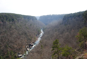
There are just a few places in Eastern Alabama worthy of hiking at, and Little River Canyon is definitely one of them. The canyon is over a dozen miles long, and it is bordered by the Sand Mountain Ridge to its west, and the Lookout Mountain Ridge to its east. There are lots of interesting rock formations around the canyon, and in the canyon, while Little River rushes through with whitewater. Little River Falls is the biggest waterfall on Little River, although there are small slides in its course too. This hike occurred on Saturday, March 22nd, 2014. My plans were to hike the Little River Falls Trail to Martha's Falls out and back, then drive down Little River Canyon Parkway (AL Route 176), stop by each of the overlooks, hike the Beaver Pond Loop Trail, and finally, hike the Eberhart Trail from Eberhart Point to the bottom of the canyon and Little River.


Read More
3 Comments

    About Me

    Mark Oleg Ozboyd
    I'm an avid outdoor explorer and a hobbyist landscape photographer. I'm 21 years old and have been hiking since 2011. Originally based out of Atlanta, Georgia, I started out by occasionally hiking short trails throughout well-known Georgia State Parks. During 2012 and 2013, I began to expand my trips into adjacent states, as well as into the wilder National Forest areas rather than just State Parks. Throughout the years that followed, as I slowly ran out of popular hiking trails in my area, I began to search for and hike in more seldom-visited areas. Today, you can find me out in the woods every weekend, whether it's on an official trail or bushwhacking through cross-country terrain without any paths. I now attend Washington & Lee University and am exploring Virginia and West Virginia. My other hobbies include chess, science, old music, and meteorology. I have 3 years of amateur weather forecasting experience, having studied a lot of meteorology basics over the years. I am also a student at European School of Music where I learned that music and nature have a lot in common. Listening to good music inspires me to capture nature's beauty on the camera in different aspects that also make me recall many beautiful music pieces that I've heard.​


    Dear readers: I have invested a tremendous amount of time and effort in this website and the Georgia Waterfalls Database the past five years. All of the work that has gone in keeping these websites updated with my latest trip reports has almost been like a full-time job. This has not allowed me to pick up a paid job to save up money for college, and therefore, I I've had to take out loans. If you find the information on this website interesting, helpful, or time-saving, you can say "thanks" and help me out by clicking the button above and making a contribution. I will be very grateful for any amount of support you give, as all of it will apply toward my college tuition. Thank you! 

    Enter your email address to subscribe for trail reports:

    Delivered by FeedBurner


    Picture
    Coming in 2022-2023?

    Other Hiking Websites

    DWHike's Adventures
    Florida's Natural Wonders
    Florida Trailblazer
    Meanderthals
    Mountain Images
    by Bernie Boyer

    North Carolina Waterfalls with
    ​Kevin Adams
    Take-a-Hike!
    Tennessee Landforms
    Waterfall Page
    Waterfall Adventurer
    Zach's Mild Adventures

    Miles Hiked

    Year 1: 540.0 Miles
    Year 2: 552.3 Miles
    ​Year 3: 518.4 Miles
    Year 4: 482.4 Miles
    Year 5: 259.9 Miles

    Archives

    March 2021
    February 2021
    January 2021
    November 2019
    October 2019
    September 2019
    August 2019
    July 2019
    June 2019
    February 2019
    January 2019
    December 2018
    November 2018
    October 2018
    August 2018
    July 2018
    June 2018
    May 2018
    April 2018
    March 2018
    February 2018
    January 2018
    December 2017
    November 2017
    October 2017
    September 2017
    August 2017
    July 2017
    June 2017
    May 2017
    April 2017
    March 2017
    February 2017
    January 2017
    December 2016
    November 2016
    October 2016
    September 2016
    August 2016
    June 2016
    May 2016
    April 2016
    March 2016
    January 2016
    December 2015
    November 2015
    October 2015
    September 2015
    August 2015
    July 2015
    June 2015
    May 2015
    April 2015
    March 2015
    February 2015
    January 2015
    December 2014
    November 2014
    October 2014
    September 2014
    August 2014
    July 2014
    June 2014
    May 2014
    April 2014
    March 2014
    February 2014

    Categories

    All
    Adel
    Adirondack Park
    Alabama
    Alfred A. Ring Park
    Allegheny Trail
    Amicalola Falls State Park
    Anniston Area
    Apalachicola Bluffs And Ravines Preserve
    Apalachicola National Forest
    Apalachicola/Port St. Joe Area
    Apopka
    Appalachian Trail
    Appling
    Art Loeb Trail
    Aska Trail System
    Bakersville
    Balm-Boyette Scrub Preserve
    Balsam Lake Recreation Area
    Bankhead National Forest
    Bartow County Parks
    Bartram Trail
    Basinger
    Beersheba Springs
    Benton
    Benton Mackaye Trail
    Berry College Trail System
    Best Hike
    Big South Fork National Recreation Area
    Black Bear Wilderness
    Black Rock Mountain State Park
    Blairsville
    Blakely
    Blood Mountain Wilderness
    Blowing Rock
    Blue Ridge
    Blue Ridge Parkway
    Boone
    Bradenton
    Bradenton Beach
    Brasstown Bald
    Brasstown Wilderness
    Brevard
    Bryson City
    Buchanan
    Bucks Pocket State Park
    Bulow Creek State Park
    Bulow Plantation Ruins State Park
    Caesars Head State Park
    Caladesi Island State Park
    Calhoun
    Camel's Hump State Park
    Cashiers
    Caspersen Beach Park
    Catfish Creek State Park
    Caves
    CC Putnam State Forest
    Cedar Point Environmental Park
    Chatsworth
    Chattahoochee National Forest
    Chattanooga
    Chattanooga Valley
    Chattooga National Wild And Scenic River
    Cheaha Wilderness
    Cherohala Skyway
    Cherokee
    Cherokee National Forest
    Chiefland Area
    Chillhowee Recreation Area
    Chipley
    Chunky Gal Trail
    Circle B Bar Reserve
    Citico Creek Wilderness
    Citrus Wildlife Management Area
    Clarkesville
    Clayton
    Cleevland
    Cleveland
    Cloudland Canyon State Park
    Cohutta Wilderness
    Collier-Seminole State Park
    Cordele
    Cornelia
    Covington
    Crestview Area
    Crew-land-and-water-trust
    Cullowhee
    Cumberland Trail
    Dahlonega
    Dalton
    Dawson Forest Wildlife Management Area
    Dawsonville
    Dayton
    De Soto National Memorial
    DeSoto State Park
    Dillard
    Double Springs
    Ducktown
    Duncan Ridge Trail
    Dunlap
    Eagle's Rest Park
    Eastpoint
    Econfina Creek Wildife Management Area
    Eglin Air Force Base
    Elizabethton
    Elkins
    Elk Knob Game Lands
    Elk Park
    Ellicott Rock Wilderness
    Ellijay
    Emerson Point Preserve
    Englewood Area
    Enota Retreat
    Erwin
    Falling Waters State Park
    Fayetteville
    Fires Creek Recreation Area
    Fire Tower
    Flint River
    Florence Area
    Florida
    Florida Caverns State Park
    Florida Trail
    Foothills Trail
    Fort Mountain State Park
    Fort Myers Area
    Fort Payne
    Fort Payne Area
    Fort Yargo State Park
    Franklin
    Franklin Delano Roosevelt State Park
    Franklin-Marion State Forest
    Frozen Head State Park
    Gainesville
    Gainesville Area
    Gatlinburg
    George Washington National Forest
    Georgia
    Georgia Veterans Memorial State Park
    Glasgow
    Gorges State Park
    Grandfather Mountain State Park
    Great Smoky Mountains National Park
    Greeneville
    Green River Game Lands
    Gruetli-Laager
    Grundy Forest State Natural Area
    GTM Reserve
    Guana River Wildlife Management Area
    Hayesville
    Helen
    Hiawassee
    High Falls State Park
    Highlands
    Highlands Scenic Highway
    Hillsborough River State Park
    Hinson Conservation & Recreation Area
    Historic Sites
    Honeymoon Island State Park
    Hot Springs
    Huntington
    Inverness Area
    Jackson
    Jasper
    Jefferson National Forest
    Joan M. Durante Park
    Jonathan Dickinson State Park
    Jones Gap State Park
    Joyce Kilmer Slickrock Wilderness
    Joyce Kilmer - Slickrock Wilderness
    Juniper Prairie Wilderness
    Kelly Park
    Keown Falls Recreation Area
    Kolomoki Mounds State Park
    LaFayette
    Lake City Area
    Lake George Wild Forest
    Lake June-in-Winter State Park
    Lakeland Area
    Lake Placid
    Lake Russell Wildlife Management Area
    Lake Wales Ridge State Forest
    Laurel Fork North Wilderness
    Leffis Key Preserve
    Leon Sinks Geological Area
    Lexington
    Lineville
    Linville
    Linville Gorge Wilderness
    Lithia Springs
    Little Frog Wilderness
    Little Manatee River State Park
    Little River Canyon National Preserve
    Longboat Key
    Long Trail
    Lookout Mountain
    Lookout Mountain Battlefield
    Lovingston
    Lula Lake Land Trust
    Lumpkin
    Maggie Valley
    Manatee Springs State Park
    Marianna Area
    Mark Trail Wilderness
    Marlinton
    Mccaysville
    McMinville
    Mentone
    Middlesex
    Mistletoe State Park
    Monongahela National Forest
    Montreat
    Mountain Bridge Wilderness Area
    Mountain City
    Mountains To Sea Trail
    Mountains-to-Sea Trail
    Mount Rogers National Recreation Area
    Myakka River State Park
    Myron B. Hodge City Park
    Nantahala National Forest
    Naples
    Naples Area
    Natural Bridge State Park
    Neal Preserve
    New Castle
    Newport
    New River Gorge National Park
    New York
    North Carolina
    Ocala Area
    Ocala National Forest
    Ocean-to-Lake Trail
    Oconee State Park
    Oconee Station Historic Site
    Okaloacoochee Slough State Forest
    Oldsmar
    Oneida
    Orlando Area
    Ormond Beach
    Oscar Scherer State Park
    Oxford
    Palatka
    Palmetto Trail
    Panama City Area
    Panthertown Valley
    Parrish
    Paynes Creek Historic State Park
    Peaks Of Otter Recreation Area
    Pigeon Crockford Mountain Wildlife Management Area
    Pigeon-Crockford Mountain Wildlife Management Area
    Pigeon-Crockford Wildlife Management Area
    Pine Mountain
    Pinhoti Trail
    Pinnacle Park
    Pisgah Civitan Park
    Pisgah National Forest
    Pittman Center
    Pond Mountain Wilderness
    Ponds/Lakes
    Prentice Cooper State Forest
    Providence Canyon State Park
    Pumpkintown
    Quick Point Nature Preserve
    Raven Cliffs Wilderness
    Reed Bingham State Park
    Reliance
    Rice Creek Conservation Area
    Riverview Pointe Preserve
    Robbinsville
    Robinson Preserve
    Rock Creek Gorge Scenic Area
    Rock Island State Park
    Rome
    Rosman
    Sale Creek
    Salem
    Salt Springs
    Saluda
    Santa Rosa Beach
    Sarasota
    Sarasota Area
    Savage Gulf State Natural Area
    Scenic Views
    Scottsboro Area
    Sebring Area
    Sewanee
    Sheltowee Trace Trail
    Shining Rock Wilderness
    Signal Mountain
    Sipsey Wilderness
    Sky Valley
    Smithgall Woods State Park
    Snowbird Backcountry Area
    Soddy Daisy
    Soddy-Daisy
    Sopchoppy
    South Carolina
    South Cumberland State Park
    Southeastern Cave Conservancy
    Southern Nantahala Wilderness
    Sparta
    Sprewell Bluff Park
    Spring City
    Spring Hill
    Springs
    Spruce Pine
    Standing Indian Backcountry Area
    St. Augustine
    St. George Island State Park
    St. Joseph Bay State Buffer Preserve
    St. Marks Area
    St. Marks National Wildlife Refuge
    Stone Mountain
    Stone Mountain Park
    Suches
    Sumatra
    Sumter National Forest
    Suwannee River
    Swallow Creek Wildlife Management Area
    Sweetwater Creek State Park
    Sylva
    Talladega National Forest
    Tallahassee Area
    Tallulah Falls
    Tallulah Gorge State Park
    Tampa Bay Area
    Tate City
    Tate's Hell State Forest
    Tea Creek Wildlife Management Area
    Tellico Plains
    Tennessee
    Thomaston
    Toccoa
    Topsail Hill State Park
    Torreya State Park
    Townsend
    Tracy City
    Tray Mountain Wilderness
    Trenton
    Triple Creek Preserve
    Troutdale
    Unaka Mountain Wilderness
    Upper Tampa Bay County Park
    Venice
    Vermont
    Virgin Falls State Natural Area
    Virginia
    Virginia Outdoors Foundation
    Vogel State Park
    Wakulla Springs State Park
    Waleska
    Walhalla
    Wartburg
    Water Features
    Waynesville
    Weedon Island Preserve
    Weeki Wachee Preserve
    Wekiwa Springs State Park
    West Palm Beach Area
    West Virginia
    Whitehall
    White Springs
    Winder
    Withlacoochee State Forest
    Young Harris

    RSS Feed

TRAIL REPORTS

Hikes in Alabama
​Hikes in Florida
Hikes in Georgia
Hikes in North Carolina
Hikes in South Carolina
Hikes in Tennessee
Hikes in Virginia

Hiking Resources

Alabama Resources
​
Florida Resources
Georgia Resources
North Carolina Resources
​South Carolina Resources
​
Tennessee Resources

Other

Contact
Map of Hikes
Alphabetical List of Hikes
Southeast Nature Society
© COPYRIGHT 2014-2018
​ALL RIGHTS RESERVED.
Important: I disclaim any responsibility for any damage or personal injury that may occur as a result of the activities and information found on this website. All outdoor activities, especially off-trail hiking, are done at your own risk. Never hike or head into that area that may be above your fitness or experience level.
  • Home
  • Trail Reports
    • Best Hikes
    • Hikes with Scenic Views
    • Hikes with Water Features
    • Alabama
    • Georgia
    • Florida
    • North Carolina
    • South Carolina
    • Tennessee
    • Vermont
    • Virginia
  • Map
  • Hike List
  • Testimonials
  • Resources
  • Contact Us
  • Southeast Nature Society
    • Our Team
  • Georgia Waterfalls Database