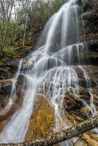
 Dozens of streams flow off the slopes of the Plott Balsam Mountains, a high, rugged range of peaks near Sylva. Most of these streams form multiple waterfalls as they cascade into the valleys, but few are as impressive as the pair of waterfalls on Buff Creek. First, Buff Creek comes over a massive cliff to form Upper Buff Creek Falls, a remote and stunning part-free-fall waterfall over 100 feet high. Even taller, Lower Buff Creek Falls comes next as the creek slides steeply down a long, broad rock slab. While the lower falls can look skinny in dry periods, the upper falls is gorgeous in almost any condition! Upper Buff Creek Falls is among the most beautiful waterfalls in southwest North Carolina, but access to it presents problems. Shortly after dropping over the lower falls, Buff Creek enters private property as it comes alongside Buff Creek Road. The only legal way to see the waterfalls is a long hike along old logging roads from the trail to Blackrock Mountain. I visited both waterfalls on Saturday, March 24th, 2018. This is not a typical trail report as I do not have enough information to provide a step-by-step guide for the public route to the waterfalls. Instead, this report serves to acknowledge the existence and beauty of these waterfalls, as well as the possible options for accessing them.
3 Comments
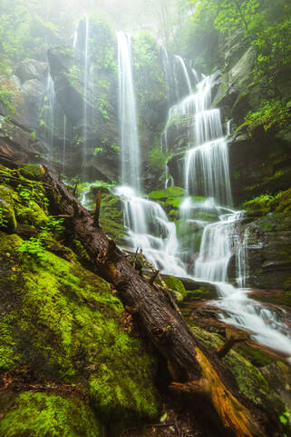 A 50-foot waterfall that spouts water from all sides of a jagged sheer cliff, accessible by a steep and tricky yet short path from the Blue Ridge Parkway: that's the matching description for English Falls. Located in Northwest North Carolina not far from the quaint town of Spruce Pine, English Falls possesses charm of a level that few other of the state's waterfalls seem to reach. The setting of the waterfall is magical, due to the lush greenery that peppers the cliffs and boulders at and around the falls. A small drawback of English Falls is that it is on a small unnamed stream, so the flow can be low during parts of the year. Nevertheless, visiting English Falls at the right time will yield one of the most unusual and photogenic waterfalls that you'll ever see. This hike occurred on Tuesday, July 11th, 2017, and a revisit occurred on Wednesday, June 17th, 2020. My plan was to hike out and back to English Falls via the access path from the Blue Ridge Parkway. In 2017, this hike was the tenth and final of ten hikes that I did during a seven-day trip to the mountains of northwest North Carolina. Update 6/23/20: I have finally revisited English Falls almost three years later. The trail has changed in several ways. English Falls has seen an explosion in visitation over the last few years so the trail is now very trampled down and eroded. As a result, the hike has actually become more difficult. The slope is very slick with few footholds or handholds. Agility and experience with ropes are a must to complete this scramble safely. The trip report has been revised with the most recent directions plus information about Upper English Falls. UPDATE JULY 2023: ROADSIDE PARKING IS NOW PROHIBITED ALL ALONG THE BLUE RIDGE PARKWAY NEAR ENGLISH FALLS. ILLEGALLY-PARKED VEHICLES WILL BE TICKETED. The nearest authorized parking area is over a mile away. The status of the scramble path itself is unclear. Most of the path lies on National Park Service land. It is widely rumored to be closed but no official word has been obtained from the NPS. 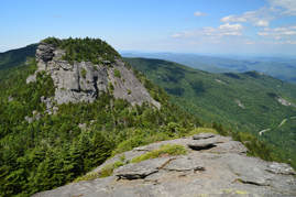
Anyone who lives in the Southeastern United States must have a hike along the crest of Grandfather Mountain on their bucket list. No words or pictures can accurately describe or convey the rugged splendor of the Grandfather Crest. Part of Grandfather Mountain is still operated as a private attraction that does allow public access under a hefty fee and a number of restrictions, but most of the mountain is land owned by the state of North Carolina in the form of Grandfather Mountain State Park. One of the secondary trailheads for Grandfather Mountain is actually off the Blue Ridge Parkway, from which several trails lead to Calloway Peak - the highest point on Grandfather Mountain. From there, the Grandfather Trail makes a very rugged traverse over two other peaks - Attic Window Peak and MacRae Peak - with many technical rock scrambles, cable sections, ladders, and of course, outstanding views. The 360-degree vistas on Attic Window Peak and MacRae Peak are of the type that you would find in Montana or Colorado rather than North Carolina. Eventually, the Grandfather Trail descends into the mountain's private section, reaching Linville Peak (where additional views await) and one of North Carolina's best-known tourist attractions: the Mile-High Swinging Bridge. This hike occurred on Monday, July 10th, 2017. My plan was to hike the Tanawha Trail, Nuwati Trail, Cragway Trail, and Daniel Boone Scout Trail to the summit of Calloway Peak, passing Top Crag View, Flat Rock View, Lynn Cove Viaduct View, and an old plane crash. Then, I would follow the Grandfather Trail over Attic Window Peak and MacRae Peak to Linville Peak and the Swinging Bridge, making side trips to Watauga View and Indian House Cave along the way. My return route would be similar, but I would use the Underwood Trail to bypass MacRae Peak, and I would use only the Daniel Boone Scout Trail instead of the Cragway Trail and Nuwati Trail for a slightly easier descent back to the trailhead from Calloway Peak. This hike was the ninth of ten hikes that I did during a seven-day trip to the mountains of northwest North Carolina.
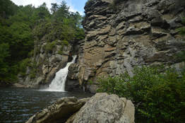
Linville Falls is one of the most photographed waterfalls in North Carolina. Located on the Linville River at the very head of Linville Gorge, the falls cascades over a hundred feet via multiple tiers, crashing into a huge plunge pool lined by tall cliffs at the end of the final 45-foot tier of the falls. A network of popular trails, stemming from the Linville Falls Visitor Center, weaves around the falls and leads to five different viewpoints of it (including the base itself). In addition, a bonus waterfall known as Duggers Creek Falls can be seen from one of the trails. This hike occurred on Friday, July 7th, 2017. My plan was to hike out and back to each of the five viewpoints of Linville Falls as well as Duggers Creek Falls from Linville Falls Visitor Center. This hike was the fifth of ten hikes that I did during a seven-day trip to the mountains of northwest North Carolina.
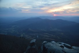
The Peaks of Otter - Sharp Top, Flat Top, and Harkening Hill - are three distinct mountains in the vicinity of the Blue Ridge Parkway. Several centuries ago, it was believed by Thomas Jefferson that the Peaks of Otter - along with the Blue Ridge Mountains in general - are the tallest peaks in the United States, but of course, this was later proved wrong, although not before stones were sampled from the Peaks of Otter and sent to be part of the Washington Monument. Hiking trails lead to each of the three peaks, and two of the three peaks provide excellent views. In fact, the rocky pinnacle at the summit of Sharp Top Mountain provides a 360-degree panorama that overlooks the Virginia Piedmont and the Blue Ridge Mountains that are scattered through the area. This hike occurred on Friday, November 25th, 2016. My plan was to hike the Sharp Top Mountain Trail out and back from Abbot Lake. I would make the short side trip to Buzzards Roost - a separate rock formation and viewpoint - along the way. This hike was the fourth of seven hikes that I did during a four-day Thanksgiving trip to the mountains of western Virginia.
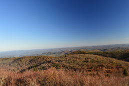 The Shining Rock Wilderness and adjacent areas is North Carolina's High Country. A multitude of peaks, some above 6000 feet, with astonishing views is accessed via rugged, wilderness pathways from the Blue Ridge Parkway. As you immerse into the backcountry of this wild region, you will also see many water features and scenic streams. My long, difficult hike in this area proved to be spectacular on one fall day when the fall colors were at peak level. This hike occurred on Saturday, October 17th, 2015. My plan was to follow the Mountains-to-Sea Trail from Looking Glass Rock Overlook to Black Balsam Road, with a stop along the way at Skinny Dip Falls and a short side trip to Second Falls in Graveyard Fields. From Black Balsam Road, I would follow the Art Loeb Trail over Black Balsam Mountain, Tennent Mountain, and to Ivestor Gap. From Ivestor Gap, I would take the Greasy Cove Trail to the Big East Fork, and finally, I would take the Big East Fork Trail back to Looking Glass Overlook. 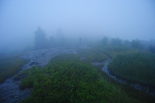 The North Carolina High Country is a beautiful area. It is part of the Pisgah National Forest, and part of it is also classified as the Shining Rock Wilderness. The NC High Country is where the mountain tops are bald, black balsam trees/forests are abundant, and steep, rushing streams descend into the valleys below to form some of the bigger rivers in the area. The drainages on the south side eventually end up in the Mills River, whereas the drainages on the north side end up in the Pigeon River. Yellowstone Prong is one of the major tributaries of the Mills River on the south side. Just below the bald summit of Black Balsam Mountain, Yellowstone Prong begins its journey southward towards the Mills River, and on the way, it passes through an outlier: a somewhat swampy, lush mountain meadow known as Graveyard Fields. This hike occurred on Saturday, July 19th, 2014, My original plan was to start at the Graveyard Fields Overlook on the Blue Ridge Parkway, hike down into Graveyard Fields via the Graveyard Fields Loop on the west side, and then take the spur trail to Upper Falls out and back. From there, I would take the Graveyard Ridge Connector to the Graveyard Ridge Trail, and the Graveyard Ridge Trail west to the Mountains-to-Sea Trail. Next, I would take the M-t-S to Black Balsam Road, and then the Art Loeb Trail over the bald summits of Black Balsam Mountain and Tennent Mountain to Ivestor Gap. From here, I would return by taking the Graveyard Ridge Trail southward back to the M-t-S. However, to add variety, I would turn left onto the M-t-S at the junction, and then return via the M-t-S Connector to Graveyard Fields Loop. Finally, I would return via the paved path out of Graveyard Fields to the parking area at the overlook. Sounds good enough, eh? Well, what actually happened was a little different. I got to a false gap what I thought was Ivestor Gap, and when I couldn't find Graveyard Ridge Trail, I took the old logging road that went to the left and connected with Ivestor Gap Trail. I followed Ivestor Gap Trail to Black Balsam Road, and finished the hike with 3 miles of roadwalk. This description will follow the actual route of my hike. Blue Ridge Parkway: Sam Knob - Flat Laurel Creek - Chestnut Bald Loop Trail, Brevard, North Carolina5/13/2014 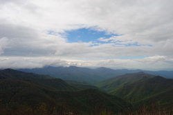 The Blue Ridge Parkway has some of the best hiking destinations in North Carolina, and this is only the second time I've been there (after Mount Pisgah three years ago). The Black Balsam/Sam Knob area is a small triangle between two wilderness areas and the Parkway. The views are grand from the whole hike, and many mountain tops are treeless. According to what I've heard, Sam Knob originally was only grass and rock, but it is being gradually covered up by brush and bushes. The views are incredible, nevertheless. This hike occurred on Saturday, May 10th, 2014. My plan was to take the Sam Knob trail from the Black Balsam Trailhead. At the junction with the Summit Trail, I planned taking the Summit Trail to the top of Sam Knob, and then go back down to the Sam Knob trail, and down to Flat Laurel Creek. After Flat Laurel Creek, I planned taking the Flat Laurel Creek Trail to the Little Sam Knob Trail, and from there, follow the Little Sam Knob Trail to the Mountains-to-Sea Trail. Finally, I planned finishing by taking the MtS to the Art Loeb Trail, and following the Art Loeb Trail to Black Balsam Road. The last part of the hike would be a road walk on Black Balsam Road. |
About MeMark Oleg Ozboyd Dear readers: I have invested a tremendous amount of time and effort in this website and the Georgia Waterfalls Database the past five years. All of the work that has gone in keeping these websites updated with my latest trip reports has almost been like a full-time job. This has not allowed me to pick up a paid job to save up money for college, and therefore, I I've had to take out loans. If you find the information on this website interesting, helpful, or time-saving, you can say "thanks" and help me out by clicking the button above and making a contribution. I will be very grateful for any amount of support you give, as all of it will apply toward my college tuition. Thank you!
Coming in 2022-2023?
Other Hiking WebsitesMiles HikedYear 1: 540.0 Miles
Year 2: 552.3 Miles Year 3: 518.4 Miles Year 4: 482.4 Miles Year 5: 259.9 Miles Archives
March 2021
Categories
All
|

 RSS Feed