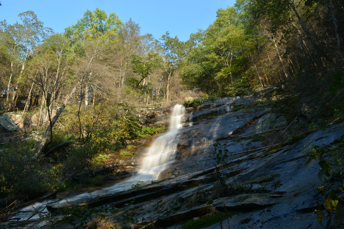
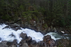
Panther Creek Falls is one of two well-known waterfalls in the Cohutta Wilderness. During high flow, the falls is quite beautiful as Panther Creek slides 80 feet down a massive cliff. But the many different wilderness approaches to Panther Creek Falls are at least as great as the falls itself. The Hickory Creek Loop approach to Panther Creek Falls is likely the most difficult and least-used, but the spectacular wilderness experience on remote trails is well worth it. On this strenuous loop hike, you'll follow the Conasauga River and cross it twice, scramble through a steep and unique boulder field, visit Panther Creek Falls and the great vista atop it, and gain over 3500 feet in elevation. If you don't feel like completing the Hickory Creek Loop in a long day hike, numerous superb campsites will allow you to split the loop into as many days as you feel comfortable. This hike occurred on Saturday, September 16th, 2017. My plan was to hike the Hickory Creek Loop counter-clockwise from the end of East Cowpen Road by following the Hickory Creek Trail, Conasauga River Trail, Panther Creek Trail, and East Cowpen Trail.
0 Comments
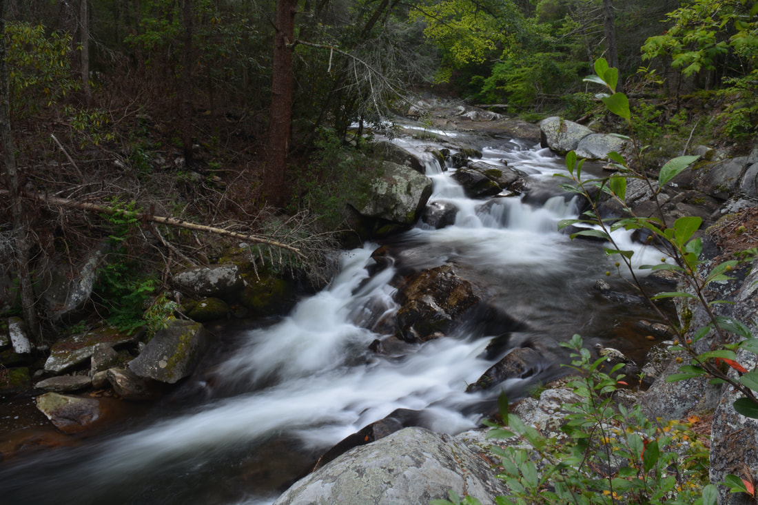
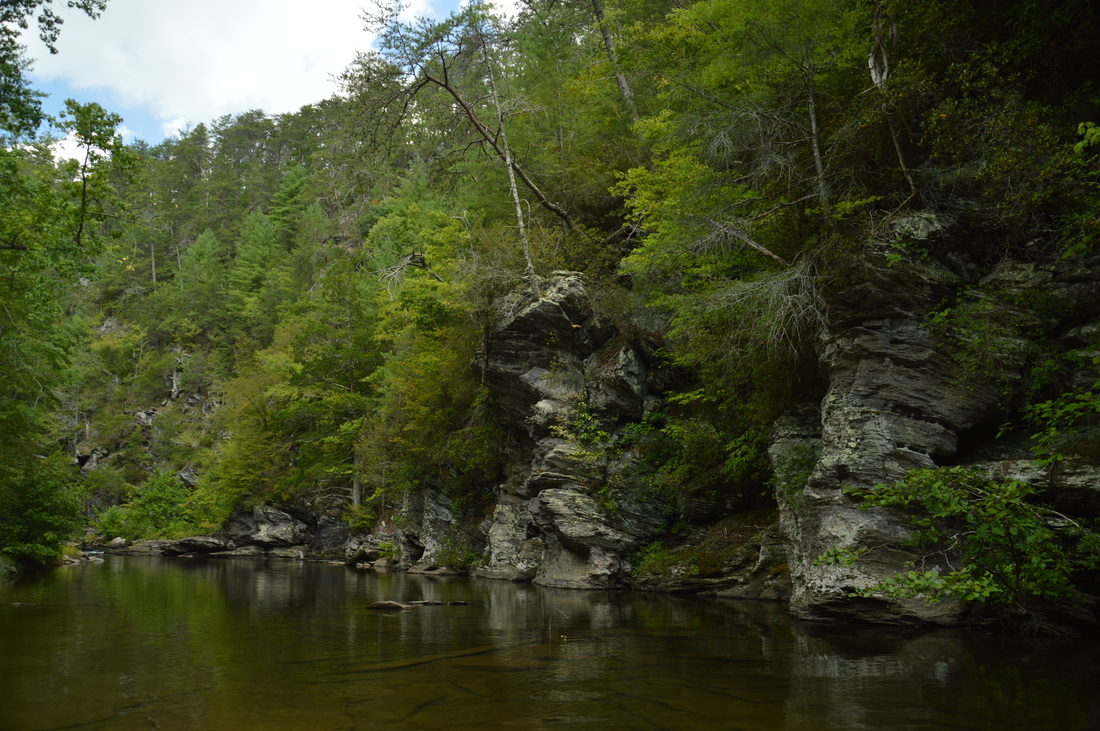
The beauty of the Conasauga River's rushing waters attracts many hikers and campers to the west side of the Cohutta Wilderness. Every single trail in this part of the wilderness crosses and follows the Conasauga at some point, but no other trail is as notable as the Conasauga River Trail. This trail follows its namesake river for nearly a dozen miles, as it gradually grows from a small rivulet at the headwaters area near Betty Gap to a wide boulder-strewn river lined by cliffs and full of swift rapids below the confluences of Rough Creek, Thomas Creek, and Hickory Creek. A whopping 38 fords of the Conasauga River - some of which are up to waist-deep - make this a fairly challenging aqua-hike, but those who choose to shuttle the full trail will be rewarded by countless scenic cascades and small waterfalls. An out-and-back hike from either end of the trail is worthwhile as well, as beautiful water features are scattered evenly throughout the river. This hike occurred on Saturday, September 2nd, 2017. My plan was to hike the Conasauga River Trail from its southern trailhead at Betty Gap on FS 64 to its northern trailhead at FS 17B. I arranged to have two cars for this point-to-point hike: one at FS 64 and the other at FS 17B.
Looking at a topographic map of the Jacks River area, one can easily make out the iconic Horseshoe Bend in the river, where the land sticks out in the form of a horseshoe. The Jacks River Trail is a trail that is over a dozen miles long and has over forty river fords, as it follows the Jacks River for much of its length and crisscrosses it numerous times. This trail provides the easiest access into the beautiful stretch of the Jacks River at Horseshoe Bend. A lesser-used trail known as the Horseshoe Bend Trail can be used to accessed the area as well, and there's also a catch: it passes mere feet away from one of the most beautiful vistas in the Cohutta Mountains. On this hike, you'll first hike through upland areas south of the Jacks River, passing the spectacular Horseshoe Bend vista, before hiking through the scenic Jacks River Gorge to Jacks River Falls. This hike occurred on Saturday, September 3rd, 2016. My plan was to follow the Horseshoe Bend Trail from FS Road 51 to the Jacks River Trail. From there, I would hike out and back along the Jacks River Trail upstream to Jacks River Falls, and then, I would follow the Jacks River Trail downstream to the Alaculsy Trailhead. I arranged to have two cars for this point-to-point hike: one car was placed at the Horseshoe Bend Trailhead and another car was placed at the Alaculsy Jacks River Trailhead.
The Eastern Continental Divide is a geographically important mountain ridge that separates the waters of the Tennessee River from the waters of the Savannah River. When hiking the Hemp Top Trail, you'll be on top of this very ridge. Just to the west of the ridge, the Cohutta Mountains' most famous river, Jacks River, is a must-see after heavy rainfall in flood stage. Just don't try to ford it... even though I forded it several times on this day (it was in flood stage), it would be a risky procedure when the river is as high as it was on this day. This hike occurred on Saturday, October 3rd, 2015. My original plan was to hike the Penitentiary Loop - to first hike the Hemp Top Trail until the Penitentiary Branch Trail. I would then hike the Penitentiary Branch Trail. I would reach the Jacks River and follow the Jacks River Trail back to the trailhead, fording the Jacks River 18 times in the meantime. However, circumstances made me hike out and back to the Jacks River area at the end of Penitentiary Branch Trail.
 The Jacks River is a turbulent waterway that is the main linear focus of the northern Cohutta Wilderness. The Jacks River Trail travels through the wilderness from the river's headwaters near Dally Gap to the wilderness boundary and the place where Jacks River flows into the Conasauga River in Alaculsy Valley. With 42 fords, the trail is the wettest trail in the Cohutta Wilderness, but also the most scenic, passing through a gorge and past a large waterfall. On this hike, you'll have a chance to experience two fords of the Jacks River, as well as see Jacks River Falls - one of the most powerful waterfalls in Georgia. This hike occurred on Saturday, March 14th, 2015. My plan was to hike the Rice Camp Loop clockwise. I would first take the Rice Camp Trail to the Jacks River. From there, I would take the Jacks River Trail upstream, stopping by Jacks River Falls long the way. Next, I would take the Hickory Ridge Trail and follow it to its terminus at the East Cowpen Trail near Buckeye Mountain. I would finish by taking the East Cowpen Trail downhill back to the trailhead.
 The Jacks River is the second largest waterway in the combined Cohutta-Big Frog Wilderness. While maybe not the largest, it is probably the most turbulent, with a large gorge and a waterfall along its course. Jacks River Falls is the highest and most powerful waterfall in the combined wilderness. Most routes require at least one deep ford of Jacks River to reach the falls. However, Beech Bottoms Trail is a good winter alternative, being the only relatively "dry" route to the falls. The only crossings will be over Beech Bottoms Creek, which may still be problematic in high water levels. This hike occurred on January 3rd, 2015. My plan was to hike the Beech Bottoms Trail southward to Jacks River Trail. Then, I would take the Jacks River Trail west to Jacks River Falls. I would return the same way.
Cohutta Wilderness: East Cowpen - Panther Creek - Conasauga River Trails Loop, Ellijay, Georgia4/30/2014  The Cohutta Mountains in North Georgia are considered as some of the oldest mountains in the world. They are part of the Cohutta Wilderness, which is part of the Chattahoochee National Forest. With nearly 100 miles of occasionally traveled trails that drop from high ridgetops to valleys full of rushing mountain water... the Cohutta Wilderness has some of the most interesting hiking opportunities in Georgia. This hike occurred on Saturday, April 26, 2014. My plan was to park at the East Cowpen Trailhead (Three Forks on USFS 64) and follow the East Cowpen Trail to the Panther Creek Trail. From there, I would take the Panther Creek Trail down into the Conasauga River Valley, and follow the Conasauga River Trail south to the Betty Gap trailhead on USFS 64. I would finish of the hike by hiking the portion of USFS 64 between Betty Gap and Three Forks back to the starting point.
|
About MeMark Oleg Ozboyd Dear readers: I have invested a tremendous amount of time and effort in this website and the Georgia Waterfalls Database the past five years. All of the work that has gone in keeping these websites updated with my latest trip reports has almost been like a full-time job. This has not allowed me to pick up a paid job to save up money for college, and therefore, I I've had to take out loans. If you find the information on this website interesting, helpful, or time-saving, you can say "thanks" and help me out by clicking the button above and making a contribution. I will be very grateful for any amount of support you give, as all of it will apply toward my college tuition. Thank you!

Coming in 2022-2023?
Other Hiking WebsitesMiles HikedYear 1: 540.0 Miles
Year 2: 552.3 Miles Year 3: 518.4 Miles Year 4: 482.4 Miles Year 5: 259.9 Miles Archives
March 2021
Categories
All
|
 RSS Feed