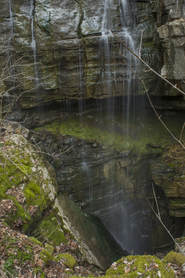
Chamberlain Trail is one of only two trails that ascends the east side of Pigeon Mountain from base to top. This lesser-known trail climbs at an easy to moderate pace through Atwood Gulf before meeting up with the Atwood Trail atop the mountain. While there aren't any notable attractions along the trail itself, a fantastic natural sight lies off-trail in Atwood Gulf: Nash Pit Falls. Have you ever heard the words pit and waterfall in one sentence? At Nash Pit Falls, a small stream flows out of a cave and instantly drops over 70 feet into the Nash Pit, a small but deep hole in the ground. In addition to the stunning Nash Pit Falls, this hike also visits a pair of McLemore Cove vistas on High Point - the highest point on Pigeon Mountain. This hike occurred on Saturday, January 13th, 2018. My plan was to hike the Chamberlain Trail from Chamberlain Road to Atwood Trail, making the bushwhack to Nash Pit Falls along the way. Next, I would follow the Atwood Trail to the Pocket/Bluff Trail. I would then follow the Pocket Trail and Bluff Trail in conjunction to the views on High Point. I would retrace my steps the same way.
2 Comments
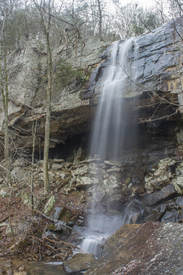
The Lost Wall is a bluff line that follows the east side of Pigeon Mountain for several miles. It's popular with rock climbers, and a trail follows the cliffs, passing many climbing access points. Only 0.15 miles from the trail's beginning at Rocky Lane, Dickson Creek comes over the Lost Wall and forms a 70-foot waterfall. During wet periods, free-falling Dickson Falls is one of the best waterfalls in the northwest corner of Georgia. The best part about it is how easily one can get to it! This hidden jewel is great for the whole family. This hike occurred on Saturday, January 13th, 2018. My plan was to hike the unofficial Lost Wall Trail out and back to Dickson Falls.
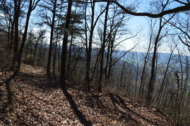
Everyone knows about Rock City. But what about Rocktown? No, Rocktown is not a miniature version of Rock City; Rocktown is an area of natural bizarre rock formations on top of Pigeon Mountain, popular with rock climbers and hikers. A network of lesser-traveled trails lies in the vicinity, providing access to Allen Creek Falls - a small but picturesque waterfall on Allen Creek - as well as winter views from Pigeon Mountain's west brow. Another such trail, Hogjowl Trail, provides a rarely-used route from McLemore Cove to the top of Pigeon Mountain. This hike occurred on Saturday, February 18th, 2017. My plan was to hike the Hogjowl Trail from west to east as the first leg of a balloon loop. Then, I would take the Bluff Trail south to Rape Gap, from where I would follow a series of forest roads to potential viewpoints of the Allen Creek Gorge (later discovering that it was not worthwhile). After this, I would return to the Atwood Trail and follow it to Allen Creek Falls, after which I would take the Hood Trail and then a short connector trail to Rocktown. I would follow the Rocktown Trail from Rocktown out to the Rocktown Trailhead. Following a brief roadwalk to Sawmill Lake, I would pick up the Hogjowl Trail and hike it west back to McLemore Cove.
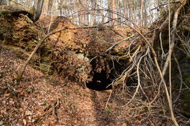
Ellison's Cave is one of the most famous caves in the US, and for good reason: the cave has the deepest unobstructed underground pitch - the Fantastic Pit - in continental US. While navigating through the over 12-mile long cave requires serious training, skills, and lots of caving equipment, the entrance to the cave can simply be viewed from a hiking trail. Ellison's Cave is just one of Pigeon Mountain's many unique highlights. Another such highlight is the Estelle Mines and Tunnels. Iron ore was mined on the northwestern side of the base of Pigeon Mountain and was transported by rail through six tunnels to the former mining town of Estelle. Operations at the site ceased in 1924, and today, all that remains are some ruins of the town of Estelle and the railroad tunnels. While some of the tunnels have caved in, others are intact and can even be walked through. On this hike, you'll visit both Ellison's Cave and the Estelle Mines, each of which would be a worthwhile destination even by itself. This hike occurred on Saturday, January 14th, 2017. My plan was to hike the Blue Hole Trail from Blue Hole past both the dug entrance and historic entrance of Ellison's Cave to the top of Pigeon Mountain. From there, I would hike the Estelle Mines Loop (a combination of Pocket Trail, Estelle Mines Trail, Bluebird Gap Shortcut, and Bluff Trail) clockwise, passing Pocket Falls and all of the Estelle Mines railroad tunnels.
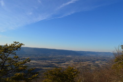 Pigeon Mountain is a giant extension of the Cumberland Plateau in northwest Georgia, spread away from the rest of the plateau that generally lies along and northwest of a I-59 in Alabama and Georgia to I-75 in Tennessee corridor. There are some differences in Pigeon Mountain from the rest of the plateau. The elevation is slightly higher, the canyons are less rugged, and the terrain is less rocky. There are a few mountain vistas and water features, but did you know what the place is most famous for? It's Ellison's Cave, one of the biggest and deepest caves in North America. Ellison's Cave contains The Fantastic Pit, which at over 500 feet in depth, is the deepest cave pit in the US. On this hike, you'll have a chance to see a few best-in-winter vistas from the highest point on the mountain, simply known as High Point, and also take a short side trip and see the entrance to Ellison's Cave. This hike occurred on February 7th, 2015. My plan was to hike the High Point Loop counter-clockwise, starting from the Pocket Trailhead. There would be stops along the way at South Pocket Falls, High Point, and possibly Ellison's Cave, if there would be clear signage to it, as I forgot to look up precise directions to it.  The Pigeon-Crockford Mountain Wildlife Management Area lies on some of the southernmost extents of the Cumberland Plateau in Georgia. Even though the elevations are generally at or lower than 2000 feet across this area, it is still quite beautiful. The WMA has numerous hiking trails, and while many are not particularly interesting, they are not excessively hard, relaxing, with some rewards. In terms of wildlife, deer and turkeys are abundant, although there are a few bears as well. This hike occurred on Saturday, June 14th, 2014. My plan was to start my hike at the Hood Overlook, and follow the Atwood trail to the Hood Trail. From there, I would follow the Hood Trail to the southern end of the Atwood Trail, and follow the Atwood Trail back to the Hood Overlook. Along the way, I would stop at Allen Creek Falls. |
About MeMark Oleg Ozboyd Dear readers: I have invested a tremendous amount of time and effort in this website and the Georgia Waterfalls Database the past five years. All of the work that has gone in keeping these websites updated with my latest trip reports has almost been like a full-time job. This has not allowed me to pick up a paid job to save up money for college, and therefore, I I've had to take out loans. If you find the information on this website interesting, helpful, or time-saving, you can say "thanks" and help me out by clicking the button above and making a contribution. I will be very grateful for any amount of support you give, as all of it will apply toward my college tuition. Thank you!
Coming in 2022-2023?
Other Hiking WebsitesMiles HikedYear 1: 540.0 Miles
Year 2: 552.3 Miles Year 3: 518.4 Miles Year 4: 482.4 Miles Year 5: 259.9 Miles Archives
March 2021
Categories
All
|

 RSS Feed