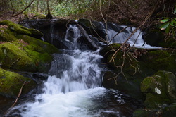
Located to the north of the Cherohala Skyway in southeastern Tennessee, the Citico Creek watershed offers rugged, wilderness hiking opportunities for true hiking enthusiasts. On this hike, you'll have a chance to see three waterfalls in the beautiful setting of the headwaters of North Fork Citico Creek. In addition, you have an option of continuing past the waterfalls and attempting to return down Brushy Mountain Trail - maybe your luck will be better than mine. This hike occurred on Saturday, March 21st, 2015. My plan was to hike the South Fork Trail to the place where North Fork Trail starts, and then to follow the North Fork Trail to Cold Springs Gap Trail or perhaps to Cherry Log Gap. I would either take the Benton Mackaye Trail or Cold Springs Gap Trail to Brushy Mountain Trail. Then, I would start down the Brushy Mountain Trail and hopefully make it down back to South Fork Trail without any major problems. My plan didn't materialize, and I ended up backtracking from about 1 mile down the Brushy Mountain Trail.
1 Comment
 The Tellico River watershed is home to some of the most pristine and beautiful streams in Tennessee. Two wilderness areas, Bald River Gorge Wlderness and Citico Creek Wilderness, protect some of its major tributaries, and many hiking trails pass through the region. One of the more notable trails is the Benton Mackaye Trail, a nearly 300-mile trail that start in northern Georgia and ends in the Smoky Mountains. The section of the Benton Mackaye Trail described here is long and hard, but the view at the end is stunning. However, if you go, don't be like me and end up hiking nearly 30 miles instead of no more than 17 from one mistake. This hike occurred on January 31st, 2015. My plan was to hike the Benton Mackaye Trail from Tellico Trout Hatchery at the Tellico River to Whiggs Meadow. Much of this hike would also be along Sycamore Creek Trail. From Whiggs Meadow, I opted for a shorter return route, along Whiggs Ridge Trail... except I didn't find the trail. I will explain more on this later.
 The Jacks River is the second largest waterway in the combined Cohutta-Big Frog Wilderness. While maybe not the largest, it is probably the most turbulent, with a large gorge and a waterfall along its course. Jacks River Falls is the highest and most powerful waterfall in the combined wilderness. Most routes require at least one deep ford of Jacks River to reach the falls. However, Beech Bottoms Trail is a good winter alternative, being the only relatively "dry" route to the falls. The only crossings will be over Beech Bottoms Creek, which may still be problematic in high water levels. This hike occurred on January 3rd, 2015. My plan was to hike the Beech Bottoms Trail southward to Jacks River Trail. Then, I would take the Jacks River Trail west to Jacks River Falls. I would return the same way.
 Big Frog Mountain is the highest mountain in southeastern Tennessee, topping out at over 4000 feet. The mountain and surrounding areas are protected by the combined Cohutta - Big Frog Wilderness. The newest addition to the area, though, is the Little Frog Wilderness, a smaller tract of land across from Big Frog Wilderness and US Highway 64. This tract protects the Panther Knob area, the better portion of Dry Pond Lead, and Rock Creek/Pressley Cove. Two trails, the Dry Pond Lead Trail and the Rock Creek Trail, provide access to the wilderness area, and you won't regret hiking them. This hike occurred on November 15th, 2014. My plan was to hike through most of the Little Frog Wilderness by starting at the Rock Creek Trailhead and hiking the entire Rock Creek Trail to the junction with the Dry Pond Lead Trail/Benton Mackaye Trail. Here, I would turn south onto the Dry Pond Lead Trail and follow it to US-64 and Ocoee Powerhouse No. 3. Then, I would enter the Tanasi Trail System, and take the Thunder Rock Express Trail to the Chestnut Mountain Trail. Next, I would follow the Chestnut Mountain Trail east, before exiting onto the Bear Paw Paw Trail that would lead down to Ocoee Whitewater Center. I would close the loop by hitchhiking 0.8 miles of US-64 to Rock Creek Trailhead (something I wouldn't recommend you to do!).
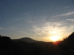
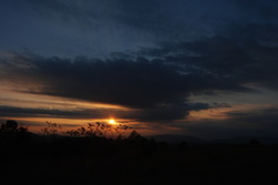 Polk County, Tennessee, is the Gateway to the Cherokee National Forest. In this beautiful corner of extreme southeast Tennessee, the rivers cut their way through valleys, bordered by the low-lying peaks of the Unicoi Mountains. The Benton Mackaye Trail's route goes straight through the area, following rolling hills and wooded slopes. One of the more prominent landmarks in the area is called Buck Bald, a small mountain with the summit being nothing more than a grassy clearing accessible via Buck Bald Road. While the BMT doesn't directly go over the top, it passes close by, and access to the bald is easy. This hike occurred on Saturday, October 25th, 2014. My plan was from Highway 68 to follow the Benton Mackaye Trail north to Buck Bald Road, and then take Buck Bald Road to the summit of Buck Bald. This short hike is an excellent way to spend your afternoon and watch the sunset.
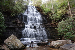 In the Ocoee District of the Southern Cherokee National Forest in Tennessee is the Ocoee River. It is surrounded by the mountains of the Chillhowee Ridge to its north, and the Cohutta Mountains to its south. While the Chillowhee Mountains are not high at all, just above 2000 feet, it was still rather attractive to check out some of the 20+ miles of trails in the Chillhowee Recreation Area. Benton Falls is the key attraction in the area, as Clear Creek tumbles 65 feet down a natural rock ledge. This hike occurred on Saturday, March 15th, 2014. My plans were to park at the Gazebo Overlook trailhead on Oswald Dome Road, to take the Gazebo Trail to McKamy Lake, then take Benton Falls Trail to Benton Falls, followed by Clemmer Trail to Rim Rock Trail, then take Rim Rock Trail to Clear Creek Trail, and finally use Clear Creek Trail to get back to the trailhead.
|
About MeMark Oleg Ozboyd Dear readers: I have invested a tremendous amount of time and effort in this website and the Georgia Waterfalls Database the past five years. All of the work that has gone in keeping these websites updated with my latest trip reports has almost been like a full-time job. This has not allowed me to pick up a paid job to save up money for college, and therefore, I I've had to take out loans. If you find the information on this website interesting, helpful, or time-saving, you can say "thanks" and help me out by clicking the button above and making a contribution. I will be very grateful for any amount of support you give, as all of it will apply toward my college tuition. Thank you!

Coming in 2022-2023?
Other Hiking WebsitesMiles HikedYear 1: 540.0 Miles
Year 2: 552.3 Miles Year 3: 518.4 Miles Year 4: 482.4 Miles Year 5: 259.9 Miles Archives
March 2021
Categories
All
|
 RSS Feed