
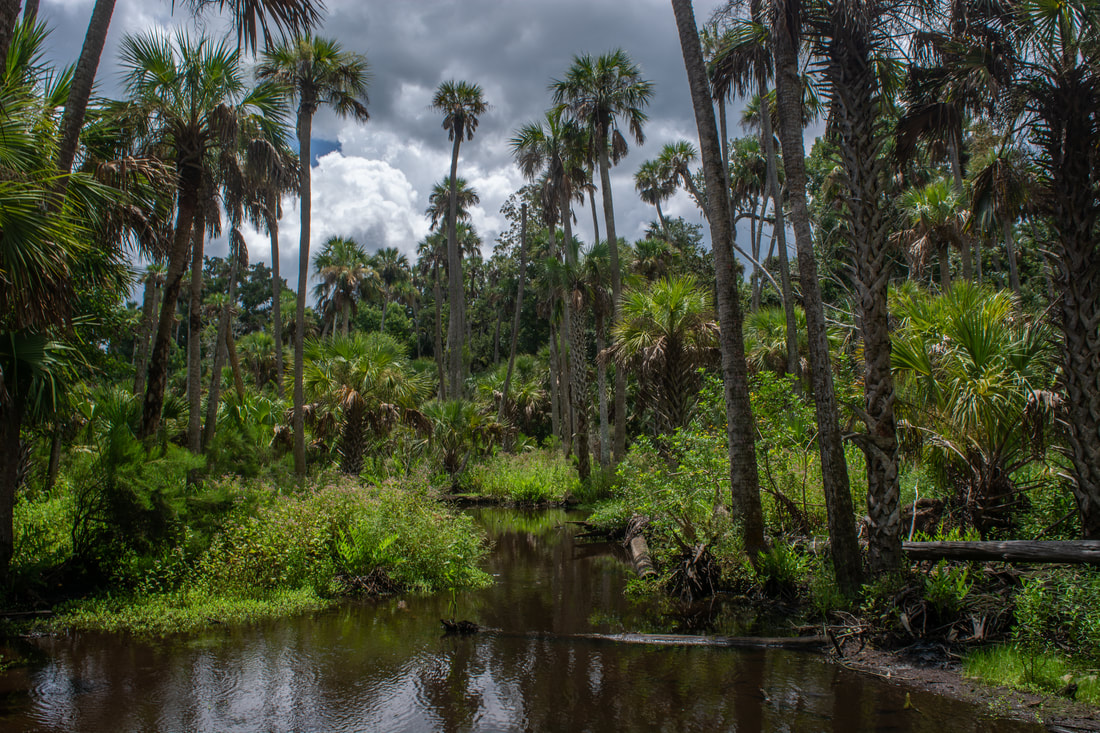
Just northeast of St. Augustine is a unique sliver of land stretching out between two estuarine bodies of water: the Tolomato River and the Guana River. The southern tip of the peninsula is occupied by the Guana Tolomato Matanzas (GTM) National Research Reserve, while the rest of it is protected by state-owned Guana River WMA. These two public land tracts are interconnected, both featuring an abundance of hiking trails surprisingly known little outside of the local community. The GTM Reserve trail system explores fairly dense woods with primarily oaks and pines, occasionally passing views of the Tolomato River. The character of the Guana River WMA trail system is vastly different. The west side of the WMA is uninteresting pine flatwoods, but it has a significant highlight: the Capo Creek observation tower. This tower provides breathtaking views of salt marshes along Capo Creek - a tidal creek feeding into the Tolomato River. The east side of the WMA features scenic hammocks along the shoreline of Guana Lake/River. The views from the Guana Lake observation tower don't quite match those of the Capo tower, but they're quite scenic as well. Regardless of whether visitors explore GTM Reserve, Guana River WMA, or both, they're likely to have a well-rounded hike with several scenic stops. This hike occurred on Saturday, August 18th, 2018. My plan was to hike a loop with the Purple Trail, Red Trail, and Blue Trail in GTM Reserve, followed by a loop to Capo Tower and Lake Tower in Guana River WMA.
0 Comments
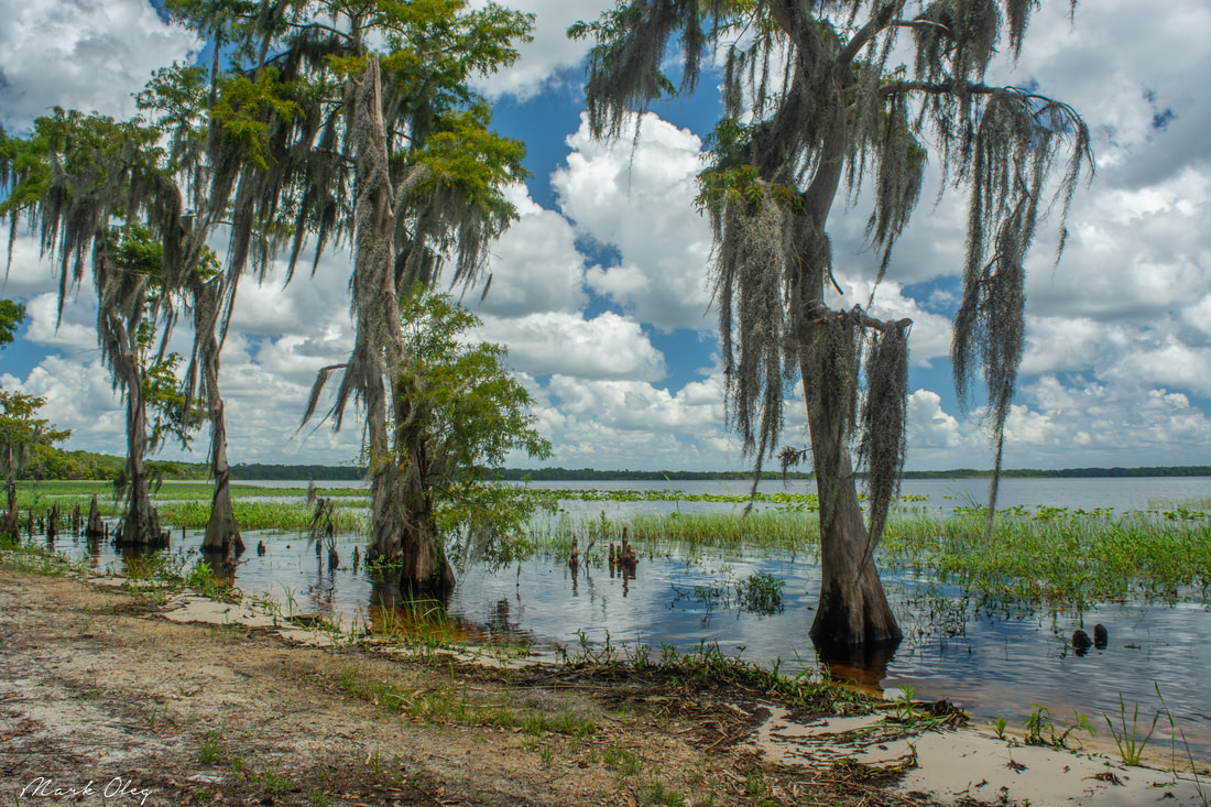
A slice of wilderness along Florida's Atlantic coastline, Bulow Creek State Park conserves several thousand acres of salt marshes and old-growth tropical hammocks in the Bulow Creek watershed between Ormond Beach and Flagler Beach. Traversing the park is the linear Bulow Woods Trail, a linear pathway over 6 miles long that takes you past several salt marsh views and through a tropical jungle with many old-growth palms and oaks. One of the hike's bigger highlights is a gorgeous palm-lined stream flowing toward Bulow Creek encountered along the north part of the trail. Between the magnificent 400-year old Fairchild Oak at the south end and the ruins of the largest sugar mill ever operated in Florida (the Bulow Sugar Mill & Plantation Ruins) at the north end, the Bulow Woods Trail has attractions even at its edges. This hike occurred on Saturday, August 11th, 2018. My plan was to hike out and back from the Fairchild Oak to the Bulow Plantation Ruins, hiking the Bulow Creek Loop counter-clockwise along the way. I would also stop at Boardman Pond.
Hiking in Florida typically means looking for certain highlights such as interesting woods, creeks, lakes, or historic sites. But what if you could fit all of that into one hike? That's something the north loop at the Arbuckle Tract of Lake Wales Ridge State Forest manages to accomplish. In under just 14 miles, this trail visits the shorelines of Lake Arbuckle and Lake Godwin, affords numerous views of both Reedy Creek and Livingston Creek, and passes through a variety of different woods and ecosystems that range from unique pine flatwoods full of cutthroat seep grass to open, sandy scrub areas. This hike is easily among the most scenic I've done in Central Florida. Not often do you find such a mix of beautiful scenery on a single trail in Florida, keeping your interest piqued and letting the miles roll by faster. This hike occurred on Saturday, August 4th, 2018. My plan was to hike the North Loop in the Arbuckle Tract counter-clockwise from McLean Cabin Trailhead.
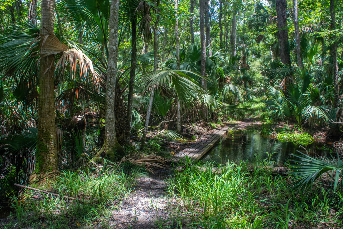
7000-acre Wekiwa Springs State Park is part of a ribbon of wild lands surrounding the St. Johns River on the northwest side of Orlando. The park's centerpoint is Wekiwa Springs, a second-magnitude spring that discharges 45 million gallons of water a day. However, there's a lot more to see in this park, which is crisscrossed by a series of single-track trails maintained by the Florida Trail Association. This hike follows the outermost White Trail all the way from Wekiwa Springs to the park's remote northern reaches. In the first half of the hike, you'll follow an elevated tramway through the wild Mill Creek Swamp and then immerse yourself into the palm hammocks of the Rock Springs Run floodplain, where you'll occasionally get your feet wet (particularly in the rainy season). A stark difference is found in the hike's second half, where you'll cruise through dry sandhills and pass sinkholes. Around the hike's midpoint, an inconspicuous connector path leads into Kelly park, where you can dip your toes in the refreshingly cool waters of the breathtaking, must-see Rock Springs before resuming your hike. This hike occurred on Wednesday, August 1st, 2018. My plan was to hike the White Trail counter-clockwise, starting out along the Wet-to-Dry Boardwalk by Wekiwa Springs.

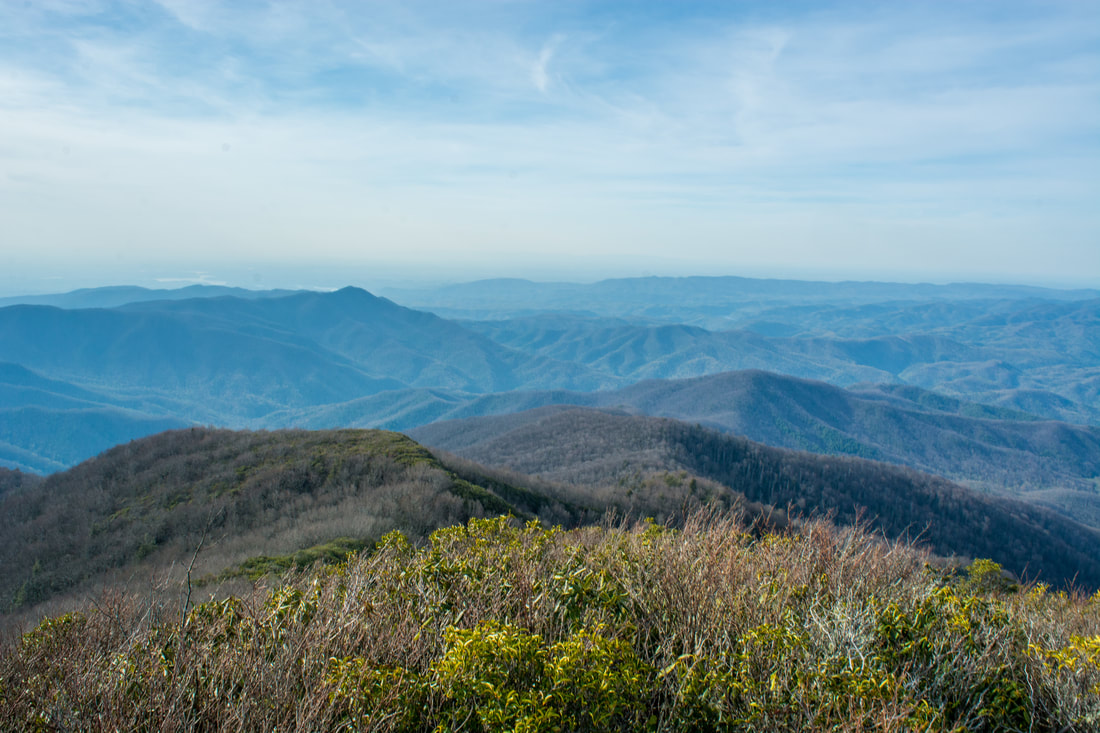
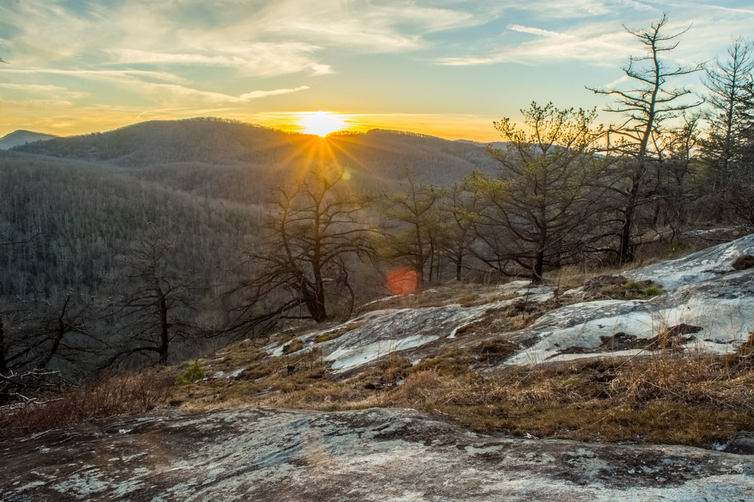
The Shining Rock Wilderness is Southwest North Carolina's high country - an area crowned by numerous 6000-foot peaks with stunning mountain views. Deep in the Little East Fork Pigeon River valley is the Daniel Boone Scout Camp, a convenient entry point to the Shining Rock Wilderness near its northern end. Two trails, Little East Fork Trail and Art Loeb Trail, leave the camp and make for a long, scenic loop visiting a number of the wilderness's highlights in its north sector. Climbing steeply out of the valley, the Art Loeb Trail's first stop is Deep Gap, where a 1.5-mile side trail leads to several panoramic overlooks atop Cold Mountain. The Art Loeb then embarks on an exciting journey through The Narrows, where a series of ups and downs along a knife-edge ridge take you past two great views and numerous rock outcrops. After a gradual climb up Stairs Mountain through gorgeous mossy spruce-fir forest, the Art Loeb approaches the wilderness's center point: Shining Rock. Featuring its own panoramic views, Shining Rock is a huge outcropping of brilliant white quartz amidst a sea of evergreen. Backpackers will find Shining Rock to be a great sunset-viewing location. Your exit route from the wilderness is the Little East Fork Trail, which descends an old roadbed along the countless pleasant cascades of Little East Fork's scenic run. This hike occurred on Saturday, June 9th, 2018. My plan was to hike the Scout Camp Loop clockwise, first hiking the Art Loeb Trail and then Little East Fork Trail. Along the way, I took side trips to Cold Mountain and Shining Rock.
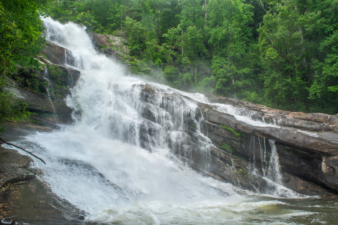
The Thompson River is one of several great rivers in the Jocassee Gorges region on the south side of Lake Toxaway. Although the Thompson River isn't as well-known as the nearby Whitewater River (due to Whitewater Falls) or Horsepasture River (due to Rainbow Falls), the Thompson features a collection of gorgeous waterfalls, including a 200-foot monster called Big Falls. Big Falls on Thompson River is an awesome, massive waterfall that crashes down through an enormous open area full of cliffs and borders. This spectacular waterfall should be on every experienced waterfaller's must-see list. Much of the hike to Big Falls follow an unofficial moderate trail along an old logging road that meanders near the Thompson River. However, the final section of the Big Falls hike is an extreme descent into the gorge, including several short rock scrambles. Along the Big Falls hike, you'll pass side trails to three other beautiful waterfalls that are all unique in their own ways and are worth seeing. This hike occurred on Saturday, May 26th, 2018. My plan was to hike out and back to Big Falls from Brewer Road. On my way in, I would make a side trip to Simon Falls. On my return trip, I would make side trips to Rich Falls and High Falls. Unfortunately, a series of heavy thunderstorms messed up my plans slightly, but it was still a great day.
Chattooga Wild and Scenic River: Long Creek Falls and Homer's Falls, Westminster, South Carolina7/5/2018 
Nearly every tributary of the Wild and Scenic Chattooga River has waterfalls of some sort. 40-foot Long Creek Falls is a particularly spectacular drop only 100 feet above the Chattooga River. Long Creek Falls is accessed by a lesser-known yet easy unofficial trail from Turkey Ridge Road (FS 755), about 1.7 miles long. The great swimming hole and large flat rocks around Long Creek Falls make it an excellent summertime destination. The Long Creek Falls Trail additionally passes a steep side path to a seldom-visited cascading waterfall on Pinckney Branch called Homer's Falls. Flowing only in wet weather, Homer's Falls flows 20 feet through an incredibly lush and mossy rock grotto before emptying into the Chattooga River. Hikers who go to Long Creek Falls even have the option of making a side trip to the top of Raven Rock Cliff, a 100-foot cliff that towers over the Chattooga River and features great gorge views. This hike occurred on Saturday, May 19th, 2018. My plan was to hike out and back to Long Creek Falls from the end of FS 755, making the side trip to Homer's Falls along the way.

Yellow Branch Falls is an absolutely phenomenal waterfall in Oconee County, South Carolina (although it needs a lot of water to look its best). Over 50 feet high, Yellow Branch Falls features a stunning clamshell-shaped drop that spreads out in countless mini-trickles across a jagged rock face. From the Yellow Branch Recreation Area off Highway 28, an easy-to-moderate hiking trail leads 1.65 miles down the Yellow Branch valley past several smaller cascades to the falls. In addition, an unnamed tributary of Yellow Branch features a 35-foot cascading waterfall called Lohr's Falls. Lohr's Falls is only for experienced waterfallers, as there's no trail whatsoever to it. This hike occurred on Saturday, May 19th, 2018. My plan was to hike the trail out and back to Yellow Branch Falls. Along the way back, I would bushwhack to Lohr's Falls.
Lee Falls is often cited as one of Upstate South Carolina's top ten most beautiful waterfalls. Over 80 feet high, Lee Falls is an absolutely stunning free-falling drop in a 'tropical paradise' setting, surrounded by lush greenery on all sides. Although the moderate trail to Lee Falls isn't official, it's easily followed for 1.5 miles all the way to the falls. Along the way, you'll pass through several overgrown wildlife clearings and make six creek crossings as you scramble up the Tamassee Creek valley to Lee Falls. The best time of year to visit Lee Falls is during late spring after a good rain, when all the lush green growth around Lee Falls is particularly eye-popping and beautiful. Just be sure to go when the water levels are high. This hike occurred on Saturday, May 19th, 2018. My plan was to hike out and back to Lee Falls.

The scenic crest of the Bald Mountains that straddles the Tennessee/North Carolina border south of Greeneville, TN, features a set of spectacular vistas in the vicinity of the Appalachian Trail. The views actually begin even before you leave your car as you arrive at the beautiful Jones Meadow with a panoramic vista of Camp Creek Bald and Blackstack Cliffs. Two excellent vistas are accessed by a very short, easy walk from the parking area: Whiterock Cliff facing south into North Carolina and Blackstack Cliffs facing north into Tennessee. The Appalachian Trail then continues onto a new section, which scrambles along the knife-edge ridge-crest for over a mile across Big Firescald Knob, affording several outstanding 360-degree panoramic vistas. On your return trip, you may choose to follow the alternate bad-weather AT route, a little-used pathway on the north flanks of Big Firescald Knob that adds variety to the hike. This hike occurred on Friday, April 27th, 2018. My plan was to hike the Appalachian Trail from Jones Meadow over Big Firescald Knob, taking side trails to Whiterock Cliff and Blackstack Cliffs along the way. Rather than retracing my steps along the Big Firescald Knob ridge-crest, I would return along the AT bad-weather bypass. This hike was the third of six hikes that I did during a four-day trip to the mountains of northeast Tennessee and northwest North Carolina.
Nestled in the Bald Mountains of Northeast Tennessee, the West Fork Dry Creek valley features some of the area's most beautiful streamside scenery. A well-known hiking trail, the Margarette Falls Trail, climbs along West Fork Dry Creek close to a mile past numerous scenic cascades to the 60-foot fan-shaped drop of Margarette Falls. Above Margarette Falls is a very unique waterfall called Bailey Falls. Accessed exclusively by an off-trail creek-walk, Bailey Falls consists of separate 30-foot upper and 20-foot lower sections in a gorgeous slot canyon. For experienced waterfallers, Bailey Falls is a must-see - no other waterfall quite like it is known in Tennessee. This hike occurred on Friday, April 27th, 2018. My plan was to hike the Margarette Falls Trail out and back to Margarette Falls. I would continue following a goat path past Margarette Falls and then walk the creek to Lower & Upper Bailey Falls. This hike was the second of six hikes that I did during a four-day trip to the mountains of northeast Tennessee and northwest North Carolina.
Just off NC 281 is a lesser-known entrance to the backcountry of Panthertown Valley: the West Fork Way trailhead. The unofficial West Fork Way ascends through the West Fork French Broad River watershed for several miles, passing the extremely steep access trail to three spectacular waterfalls: Rhapsodie Falls, Dismal Falls, and Lower Dismal Falls. West Fork Way then connects to another unofficial trail on the fringes of Panthertown Valley called the Shelton-Pisgah Trail, which follows a seldom-hiked pathway along the ridge of Shelton-Pisgah Mountain to Cold Mountain. A cliff on the west side of Cold Mountain, nicknamed the High Bethel View features an outstanding vista of Panthertown Valley spread out to the west - arguably the best of the valley's five views. This hike occurred on Saturday, May 12th, 2018. My plan was to hike West Fork Way and Shelton-Pisgah Trail out and back to Cold Mountain. Along the way, I would take the side trails to Rhapsodie Falls, Dismal Falls, and Lower Dismal Falls. I would also stop by two other small falls - Aunt Sally's Falls and Lower Rhapsodie Falls.

When you imagine a place with five spectacular waterfalls in one hike, the lowest region of the North Carolina mountains in the Green River valley - elevation 1000' - hardly comes to mind. And yet, the Green River Game Lands and adjacent areas surrounding Saluda are home to a variety of excellent water features. Perhaps the most breathtaking waterfall in the area is 75-foot Big Bradley Falls, a sheer twin drop on Cove Creek that forcefully crashes down through a cleft in an amphitheater of enormous cliffs. Less than a mile from Cove Creek, the off-trail hike up Little Cove Creek, and later its tributary, culminates in the remarkably unique Cavern Falls, where part of the 30-foot waterfall shoots through a perpetually wet and dark cavern. What's more, the hike to Cavern Falls passes three other waterfalls - all very beautiful and picturesque. This hike consists of two starkly different sections: one half along Little Cove Creek is a difficult bushwhack and creek-walk that is suitable for experienced off-trail adventurers only, whereas the other half along Cove Creek is a relatively easy stroll along a well-defined trail to an outstanding waterfall accessible to most hikers. This hike occurred on Saturday, May 5th, 2018. My plan was to begin the hike at the trailhead by Wilderness Cove Tubing and follow old farm roads to Little Cove Creek, where I would hike off-trail upstream along the creek and its tributary to Milton Bradley Falls, Bradley Cooper Falls, Marilou Bradley Falls, and Cavern Falls. On my return trip, I would take a side trail along Cove Creek to Big Bradley Falls.
Right on the doorstep of the quaint town of Robbinsville is the Joyce Kilmer-Slickrock Wilderness, a massive wild area covering over 17,000 acres between the Cherohala Skyway and US 129. The area is known best for the Joyce Kilmer Memorial Forest - an area of virgin forest in the Little Santeetlah Creek watershed, featuring numerous old, grand trees. The wilderness area's central destination, however, is an inconspicuous rock outcropping on a lead below Haoe Bald called The Hangover. The Hangover features a breathtaking 360-degree view of the wilderness, with little in sight but endless mountain ridges and several lakes. The panoramic vista atop The Hangover encompasses Santeetlah Lake, Calderwood Lake, and the Little Tennessee River. This hike loops several trails from the Joyce Kilmer Recreation Area to visit The Hangover via the Memorial Forest. This hike occurred on Saturday, April 21st, 2018. My plan was to hike a clockwise loop with the Joyce Kilmer Memorial Forest Poplar Cove Trail, Naked Ground Trail, Haoe Lead Trail, and Jenkins Meadow Trail. I would of course take a side trip along the Hangover Lead Trail to The Hangover.
The trails at the west end of Panthertown Valley feature several popular waterfalls: Wilderness Falls, Frolictown Falls, and Granny Burrell Falls, as well as a spectacular well-known cliff line on the south side of Big Green Mountain called the Great Wall. This hike visits all of these destinations, in addition to lesser-known views atop Big Green Mountain itself. This hike also follows the Deep Gap Trail out of Panthertown Valley onto the seldom-hiked Laurel Knob Trail, a climbers' access trail that leads to the base of the 1200-foot cliffs of Laurel Knob. Laurel Knob boasts of the tallest uninterrupted cliff face in the entire Eastern United States! This hike occurred on Saturday, March 31st, 2018. My plan was to start out at the Salt Rock Gap Trailhead, where I'd take the Wilderness Falls Trail past Wilderness Falls to the Deep Gap Trail at Frolictown Falls. I'd then hike the Deep Gap Trail and Laurel Knob Trail out and back to the base of the Laurel Knob cliffs. Next, I'd return to Frolictown Falls, and I'd take the Great Wall Trail toward the top of Big Green Mountain, making a side trip to Granny Burrell Falls along the way. I would then follow the Big Green Trail past several views and continue down an unofficial connector to Macs Gap Trail. Finally, I'd follow the Macs Gap Trail and Panthertown Valley Trail back out to Salt Rock Gap.
|
About MeMark Oleg Ozboyd Dear readers: I have invested a tremendous amount of time and effort in this website and the Georgia Waterfalls Database the past five years. All of the work that has gone in keeping these websites updated with my latest trip reports has almost been like a full-time job. This has not allowed me to pick up a paid job to save up money for college, and therefore, I I've had to take out loans. If you find the information on this website interesting, helpful, or time-saving, you can say "thanks" and help me out by clicking the button above and making a contribution. I will be very grateful for any amount of support you give, as all of it will apply toward my college tuition. Thank you!

Coming in 2022-2023?
Other Hiking WebsitesMiles HikedYear 1: 540.0 Miles
Year 2: 552.3 Miles Year 3: 518.4 Miles Year 4: 482.4 Miles Year 5: 259.9 Miles Archives
March 2021
Categories
All
|
 RSS Feed