HIKING THE APPALACHIANS AND BEYOND
  • Home
  • Trail Reports
    • Best Hikes
    • Hikes with Scenic Views
    • Hikes with Water Features
    • Alabama
    • Georgia
    • Florida
    • North Carolina
    • South Carolina
    • Tennessee
    • Vermont
    • Virginia
  • Map
  • Hike List
  • Testimonials
  • Resources
  • Contact Us
  • Southeast Nature Society
    • Our Team
  • Georgia Waterfalls Database

Sumter National Forest: Yellow Branch Falls and Lohr's Falls, Walhalla, South Carolina

7/4/2018

0 Comments

 
Picture
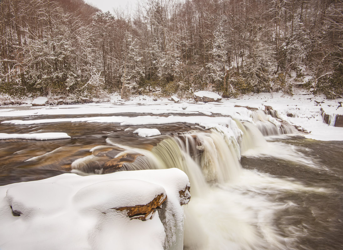
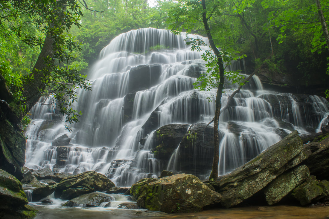
Yellow Branch Falls is an absolutely phenomenal waterfall in Oconee County, South Carolina (although it needs a lot of water to look its best). Over 50 feet high, Yellow Branch Falls features a stunning clamshell-shaped drop that spreads out in countless mini-trickles across a jagged rock face. From the Yellow Branch Recreation Area off Highway 28, an easy-to-moderate hiking trail leads 1.65 miles down the Yellow Branch valley past several smaller cascades to the falls. In addition, an unnamed tributary of Yellow Branch features a 35-foot cascading waterfall called Lohr's Falls. Lohr's Falls is only for experienced waterfallers, as there's no trail whatsoever to it. This hike occurred on Saturday, May 19th, 2018. My plan was to hike the trail out and back to Yellow Branch Falls. Along the way back, I would bushwhack to Lohr's Falls.

Summary

R/T Length of Trail: 3.3 Miles (4.4 Miles with Lohr's Falls included)
Duration of Hike: 2:30 plus 1 hour of stopping and photography
Type of Hike: Out and Back
Difficulty Rating: 4 out of 10
Total Elevation Gain: 935 Feet
Pros: Absolutely stunning waterfall 
Cons: Relatively popular trail; waterfall needs a lot of water to look good
Points of Interest: Yellow Branch Falls - 10+ stars; Lohr's Falls - 3 stars
Trail Blaze Colors: Yellow Branch Falls Trail - Lime Green
Best Seasons to Hike: Winter; Spring
Fees: None
Beginning Point: Yellow Branch Recreation Area
Directions from Walhalla, SC: From the junction of SC 183 and SC 28 in downtown Walhalla, follow SC 28 North for 5.3 miles to the Yellow branch Recreation Area entrance on the left. Drive down the short entrance road to the Yellow Branch Falls parking area.

Map

Picture
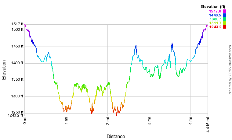
Click the link below to download a .GPX file with a track of this hike.
yellow_branch_falls_and_lohrs_falls.gpx
File Size: 171 kb
File Type: gpx
Download File

Details

Yellow Branch Falls

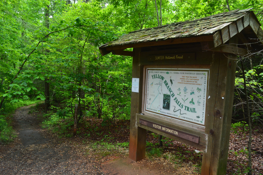
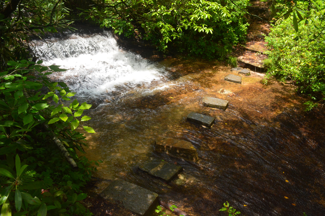
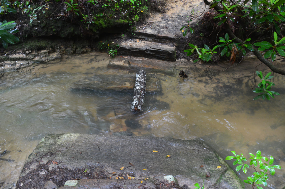
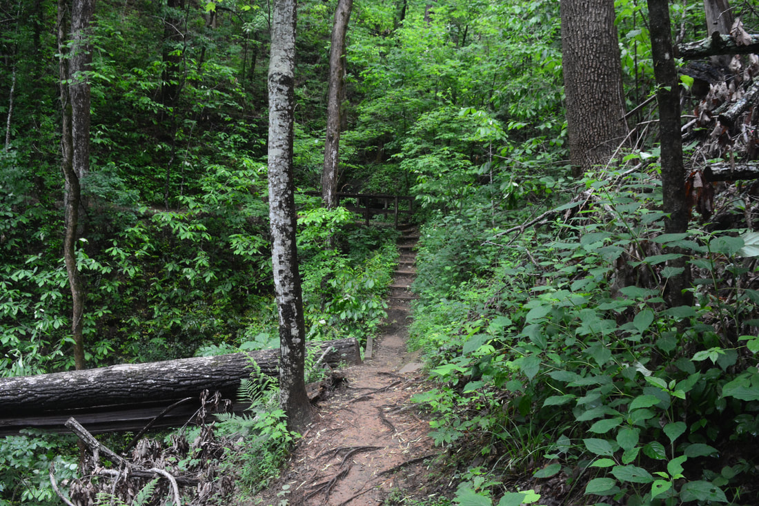
After hiking to Lee Falls earlier in the day, ​I decided to make my first visit to another waterfall best seen in high flow: Yellow Branch Falls. It had stormed all morning, and another storm moved through while I was at the falls, so crowds were kept at a minimum along this typically-popular trail. Look for the start of the Yellow Branch Falls Trail by a kiosk near the rather small parking area. The trail begins a gentle descent along Yellow Branch, passing a 6-foot cascade referred to as Little Yellow Branch Falls on the left after 150 feet. Between 0.2 miles and 0.25 miles, the trail makes three crossings of Yellow Branch in quick succession - the second one features very scenic and neat stepping stones. The Yellow Branch crossings on this hike can normally be completed dry, but if the water flow is really high, you may need to wade. 

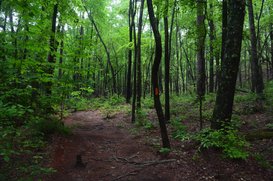
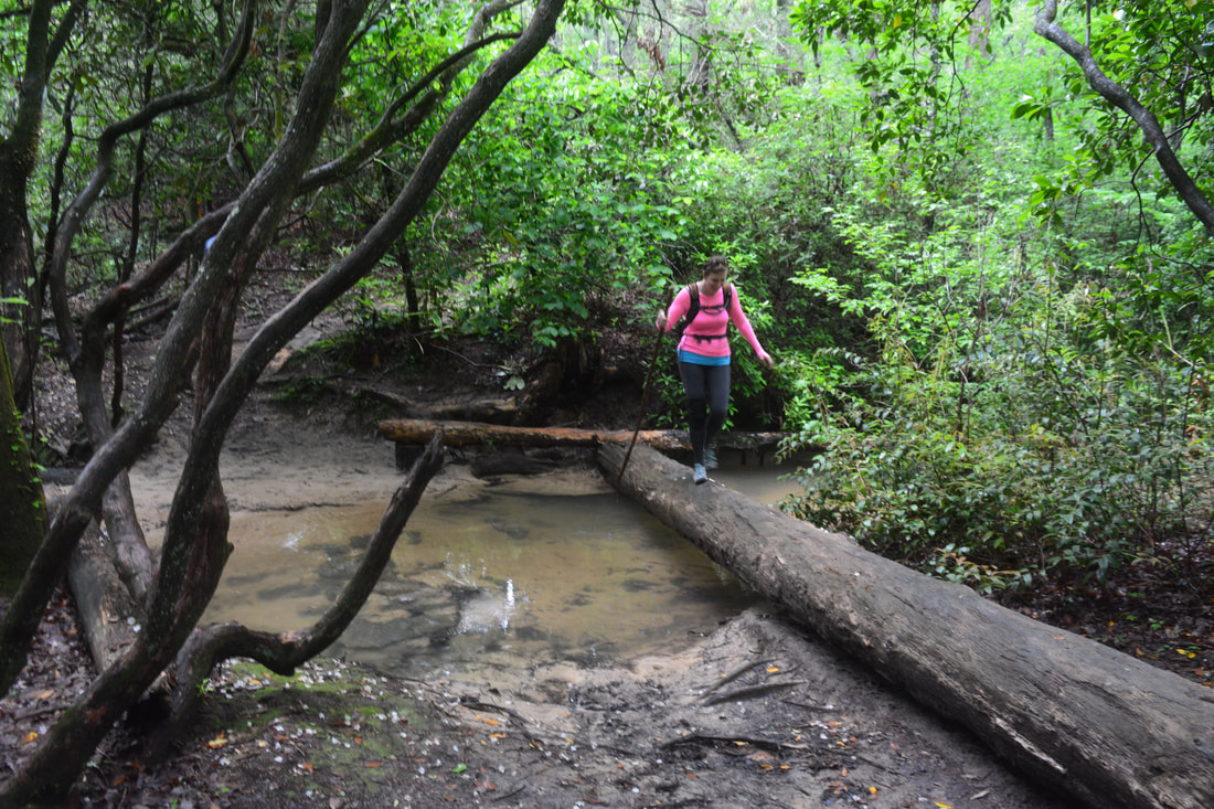
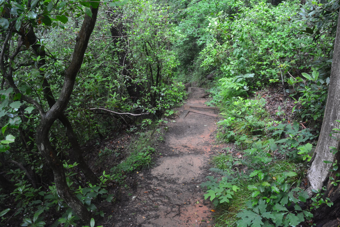
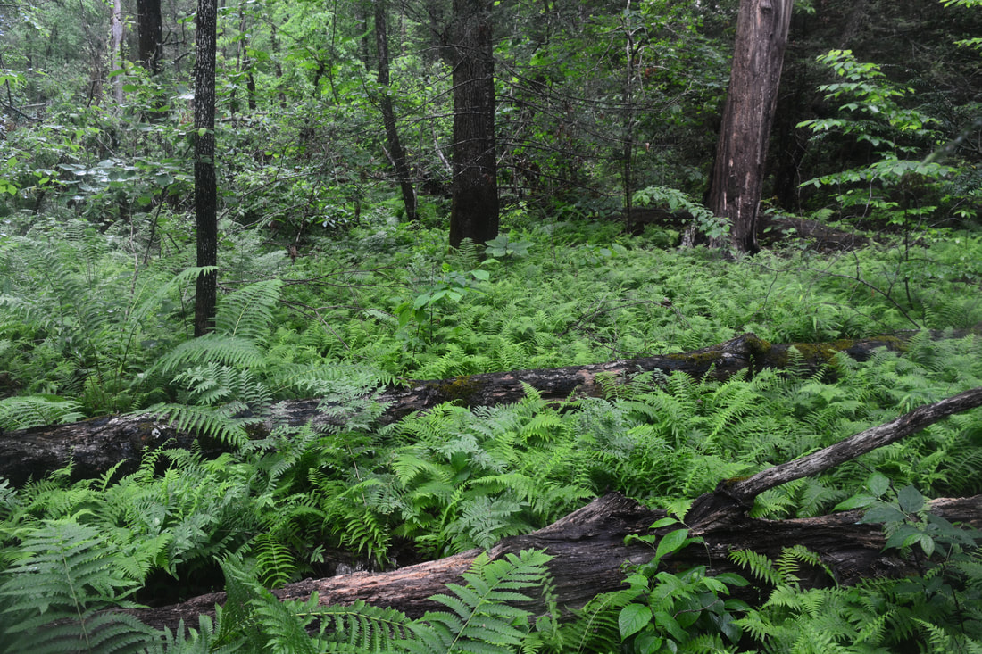
At 0.3 miles, just after passing a series of cascades sometimes called Middle Yellow Branch Falls, reach a junction. Straight ahead is an alternate access trail to Highway 28. The Yellow Branch Falls turns right and crosses Yellow Branch on a wooden footbridge. Out of the trail's five crossings of Yellow Branch, this is the only bridged one. A gentle descent through pretty forest continues. Reach the final crossing of Yellow Branch at 0.5 miles (fourth unbridged crossing). Note the path that leaves right immediately before the crossing - this is the access to Lohr's Falls, described farther below in this trail report. The path is also the start of the old trail to Yellow Branch Falls, but that trail is now closed to the public. So continue straight across the stream toward Yellow Branch Falls. A large log provides a good way across.

After this, the trail passes through a small gap and temporarily swings out of the Yellow Branch drainage. This is where a slightly steeper descent starts. The trail passes an especially large tree on the right, crosses a tiny rivulet, and begins swinging in and out of countless hollows east of Yellow Branch. Although the general trend is downhill, some uphill is mixed in. Portions of the trail in this area can be very muddy and slick after rain - I speak from experience! Finally, around 1.4 miles, the trail returns into the Yellow Branch drainage, paralleling the creek from high above downstream from Yellow Branch Falls. The trail terminates at Yellow Branch Falls at 1.65 miles. 
Picture
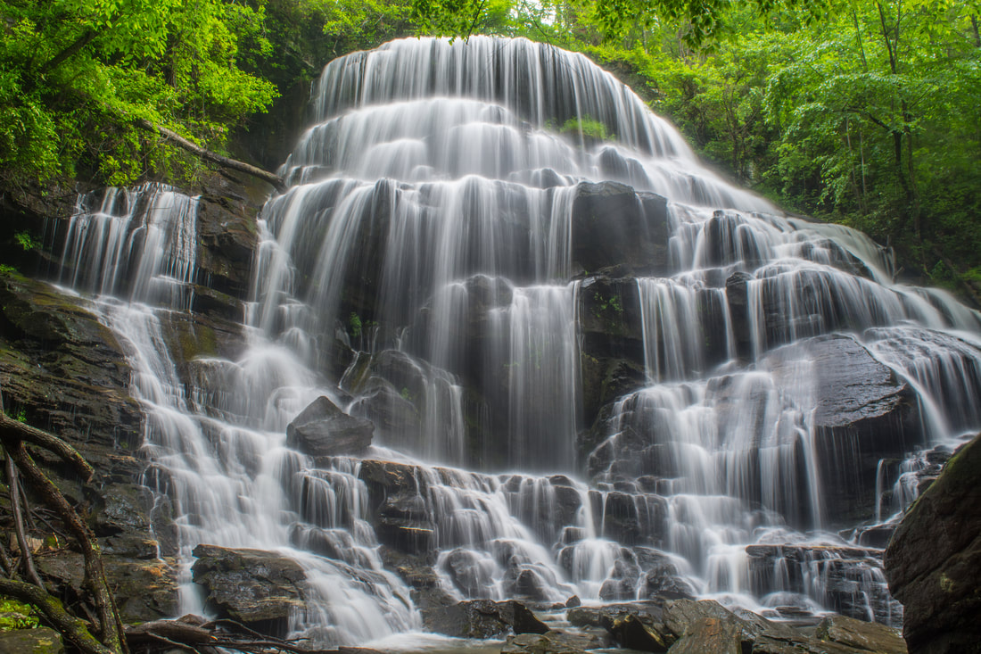
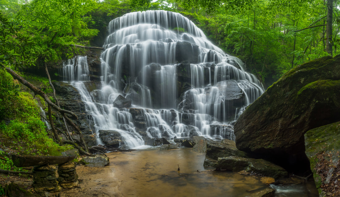
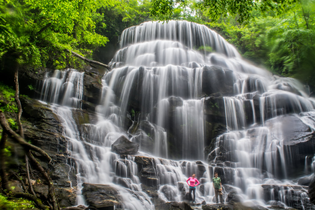
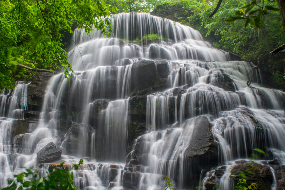
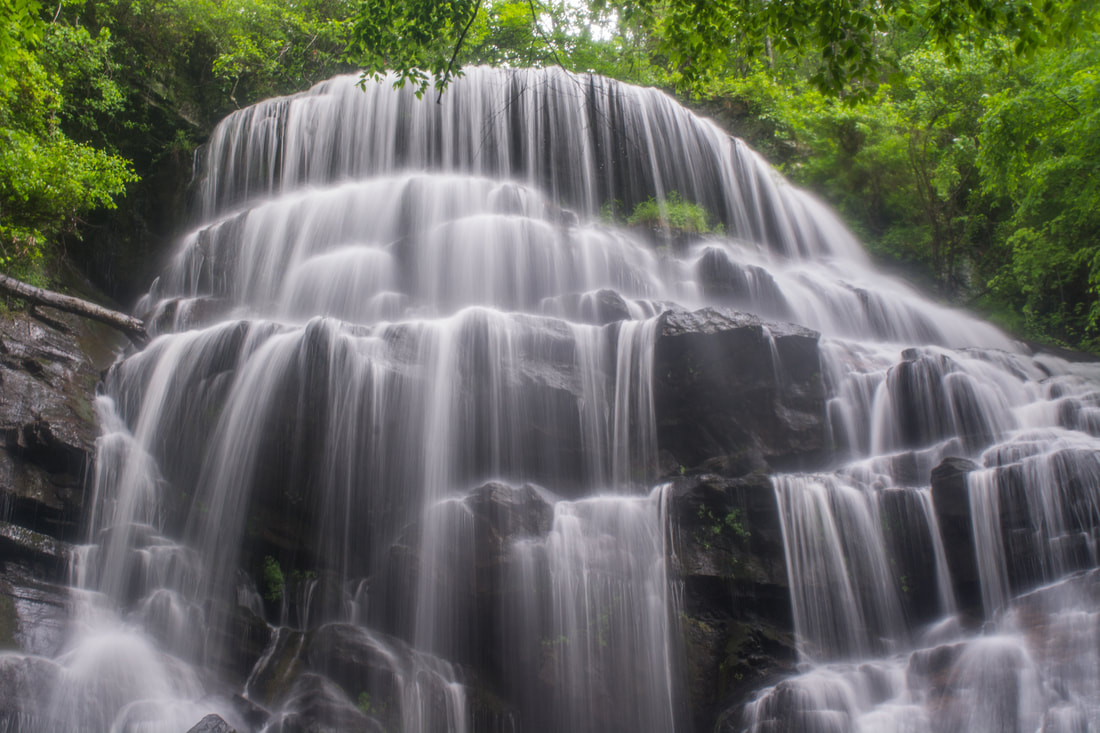
Its clamshell shape is what makes Yellow Branch Falls so unique.
​It's wonderful to have such a pleasant, well-maintained trail to a waterfall as stunningly beautiful as Yellow Branch Falls. This terrific waterfall is one of Upstate South Carolina's star waterfalls - definitely in the top 10. The waterfall's clamshell shape makes it so unique. Yellow Branch cascades in countless trickles and free-falls on all three sides of the jagged, multi-faceted rock face, which is over 50 feet high. In low water, all the different trickles aren't quite as pronounced. The waterfall is still beautiful, but it truly lives up to its "10+" rating only in high flow. If you choose to cross the creek and explore the other side of Yellow Branch Falls, you'll find that it looks totally different from that angle! I took the cover photo at the top of this trail report from the same side of the creek that the trail ends on, whereas the photo above was from the other side of the creek. For the same reason, it's extremely difficult to adequately capture all of the waterfall in one photo. A wide-angle lens or panorama will give you the best results. While you're exploring the falls, be sure to not take the old scramble trail to the top of Yellow Branch Falls. This trail is now closed to all traffic due to erosion, and you could be fined if you're seen on it. It might be tempting to take this old trail to get to Lohr's Falls more easily, but please stay away from doing so.

Simply retrace your steps back to the Yellow Branch Recreation Area from Yellow Branch Falls. If you aren't an experienced waterfaller and want to skip the side trip to Lohr's Falls, you'll conclude the hike at 3.3 miles. Otherwise, keep reading to learn more about how to see Lohr's Falls.

Lohr's Falls

The hike to Lohr's Falls begins along the path on the right at the 0.5-mile mark along the Yellow Branch Falls Trail. In 200 feet, turn left off the old logging grade and onto a narrower path. In another 200 feet, the main path curves left and ends at a pretty 10-foot cascade called Jade Falls. However, this hike continues straight on a much fainter path downstream along Yellow Branch. 0.15 miles from the trail, the path - which has been following the old route of the Yellow Branch Falls Trail - disappears completely. Simply keep picking the route of least resistance downstream, which will involve crossing a number of big downed trees. 0.25 miles from the trail, you'll cross a small stream. Continue 0.1 mile farther along Yellow Branch. Then, scramble up the hill on the right. It is best to leave Yellow Branch and climb this hill around halfway between the little stream you just crossed and the stream with Lohr's Falls. On the topo map, the "hill" is a small ridge separating the Lohr's Falls stream from Yellow Branch.

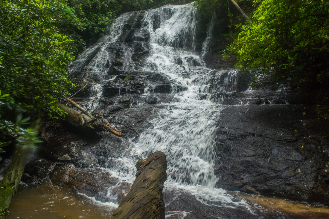
Once atop the hill, hike west toward the unnamed stream with Lohr's Falls. There are fallen trees and some overgrowth here too. The bushwhacking isn't very thick, but it's still a bit tiresome. You're likely to reach the Lohr's Falls stream at 0.5 miles from the Yellow Branch Falls Trail. From here, simply hike upstream along the route of least resistance (probably on the north, River Left side). Reach Lohr's Falls 0.55 miles from the trail. The coordinates for Lohr's Falls are N34° 47.841' W83° 08.154'.

Lohr's Falls needs a lot of water flow to look good due to its small watershed. The falls is a 35-foot stairstep cascade. It's not overly impressive, but it's scenic enough, so it's a good one for hardcore waterfallers. Lohr's Falls is named after Stu and Kathy Lohr, who in 1994, accidentally stumbled upon this waterfall due to a navigational error on their way to Yellow Branch Falls. Just above the main drop of Lohr's Falls is a scenic 15-foot corkscrew-type drop, which I chose not to hike to. If you choose to include Lohr's Falls on this hike, keep in mind that it would add 1.1 miles roundtrip, making the total hike 4.4 miles long. You should also know that this is not a very easy bushwhack, especially in the warmer months, thanks to the large amount of downed trees. 
Picture
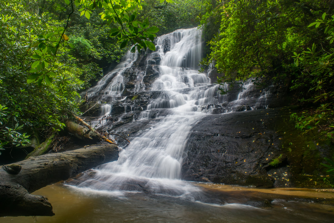
Lohr's Falls is a 35-foot stairstep cascade situated off-trail on an unnamed tributary of Yellow Branch above Yellow Branch Falls.

Mileage

0.0 - Yellow Branch Recreation Area
1.65 - Yellow Branch Falls 
​2.8 - Lohr's Falls Turn-Off 
3.35 - Lohr's Falls 
4.4 - Yellow Branch Recreation Area

Variations

Hike out and back just to Lohr's Falls - 2.1 Miles

Bonus Stops

Just up the road from Yellow Branch Recreation Area is Isaqueena Falls. This is a particularly spectacular waterfall in high flow, and it's relatively easy to reach along a well-defined, steep scramble path.

Pictures & Videos

0 Comments


Leave a Reply.

    About Me

    Mark Oleg Ozboyd
    I'm an avid outdoor explorer and a hobbyist landscape photographer. I'm 21 years old and have been hiking since 2011. Originally based out of Atlanta, Georgia, I started out by occasionally hiking short trails throughout well-known Georgia State Parks. During 2012 and 2013, I began to expand my trips into adjacent states, as well as into the wilder National Forest areas rather than just State Parks. Throughout the years that followed, as I slowly ran out of popular hiking trails in my area, I began to search for and hike in more seldom-visited areas. Today, you can find me out in the woods every weekend, whether it's on an official trail or bushwhacking through cross-country terrain without any paths. I now attend Washington & Lee University and am exploring Virginia and West Virginia. My other hobbies include chess, science, old music, and meteorology. I have 3 years of amateur weather forecasting experience, having studied a lot of meteorology basics over the years. I am also a student at European School of Music where I learned that music and nature have a lot in common. Listening to good music inspires me to capture nature's beauty on the camera in different aspects that also make me recall many beautiful music pieces that I've heard.​


    Dear readers: I have invested a tremendous amount of time and effort in this website and the Georgia Waterfalls Database the past five years. All of the work that has gone in keeping these websites updated with my latest trip reports has almost been like a full-time job. This has not allowed me to pick up a paid job to save up money for college, and therefore, I I've had to take out loans. If you find the information on this website interesting, helpful, or time-saving, you can say "thanks" and help me out by clicking the button above and making a contribution. I will be very grateful for any amount of support you give, as all of it will apply toward my college tuition. Thank you! 

    Enter your email address to subscribe for trail reports:

    Delivered by FeedBurner


    Picture
    Coming in 2022-2023?

    Other Hiking Websites

    DWHike's Adventures
    Florida's Natural Wonders
    Florida Trailblazer
    Meanderthals
    Mountain Images
    by Bernie Boyer

    North Carolina Waterfalls with
    ​Kevin Adams
    Take-a-Hike!
    Tennessee Landforms
    Waterfall Page
    Waterfall Adventurer
    Zach's Mild Adventures

    Miles Hiked

    Year 1: 540.0 Miles
    Year 2: 552.3 Miles
    ​Year 3: 518.4 Miles
    Year 4: 482.4 Miles
    Year 5: 259.9 Miles

    Archives

    March 2021
    February 2021
    January 2021
    November 2019
    October 2019
    September 2019
    August 2019
    July 2019
    June 2019
    February 2019
    January 2019
    December 2018
    November 2018
    October 2018
    August 2018
    July 2018
    June 2018
    May 2018
    April 2018
    March 2018
    February 2018
    January 2018
    December 2017
    November 2017
    October 2017
    September 2017
    August 2017
    July 2017
    June 2017
    May 2017
    April 2017
    March 2017
    February 2017
    January 2017
    December 2016
    November 2016
    October 2016
    September 2016
    August 2016
    June 2016
    May 2016
    April 2016
    March 2016
    January 2016
    December 2015
    November 2015
    October 2015
    September 2015
    August 2015
    July 2015
    June 2015
    May 2015
    April 2015
    March 2015
    February 2015
    January 2015
    December 2014
    November 2014
    October 2014
    September 2014
    August 2014
    July 2014
    June 2014
    May 2014
    April 2014
    March 2014
    February 2014

    Categories

    All
    Adel
    Adirondack Park
    Alabama
    Alfred A. Ring Park
    Allegheny Trail
    Amicalola Falls State Park
    Anniston Area
    Apalachicola Bluffs And Ravines Preserve
    Apalachicola National Forest
    Apalachicola/Port St. Joe Area
    Apopka
    Appalachian Trail
    Appling
    Art Loeb Trail
    Aska Trail System
    Bakersville
    Balm-Boyette Scrub Preserve
    Balsam Lake Recreation Area
    Bankhead National Forest
    Bartow County Parks
    Bartram Trail
    Basinger
    Beersheba Springs
    Benton
    Benton Mackaye Trail
    Berry College Trail System
    Best Hike
    Big South Fork National Recreation Area
    Black Bear Wilderness
    Black Rock Mountain State Park
    Blairsville
    Blakely
    Blood Mountain Wilderness
    Blowing Rock
    Blue Ridge
    Blue Ridge Parkway
    Boone
    Bradenton
    Bradenton Beach
    Brasstown Bald
    Brasstown Wilderness
    Brevard
    Bryson City
    Buchanan
    Bucks Pocket State Park
    Bulow Creek State Park
    Bulow Plantation Ruins State Park
    Caesars Head State Park
    Caladesi Island State Park
    Calhoun
    Camel's Hump State Park
    Cashiers
    Caspersen Beach Park
    Catfish Creek State Park
    Caves
    CC Putnam State Forest
    Cedar Point Environmental Park
    Chatsworth
    Chattahoochee National Forest
    Chattanooga
    Chattanooga Valley
    Chattooga National Wild And Scenic River
    Cheaha Wilderness
    Cherohala Skyway
    Cherokee
    Cherokee National Forest
    Chiefland Area
    Chillhowee Recreation Area
    Chipley
    Chunky Gal Trail
    Circle B Bar Reserve
    Citico Creek Wilderness
    Citrus Wildlife Management Area
    Clarkesville
    Clayton
    Cleevland
    Cleveland
    Cloudland Canyon State Park
    Cohutta Wilderness
    Collier-Seminole State Park
    Cordele
    Cornelia
    Covington
    Crestview Area
    Crew-land-and-water-trust
    Cullowhee
    Cumberland Trail
    Dahlonega
    Dalton
    Dawson Forest Wildlife Management Area
    Dawsonville
    Dayton
    De Soto National Memorial
    DeSoto State Park
    Dillard
    Double Springs
    Ducktown
    Duncan Ridge Trail
    Dunlap
    Eagle's Rest Park
    Eastpoint
    Econfina Creek Wildife Management Area
    Eglin Air Force Base
    Elizabethton
    Elkins
    Elk Knob Game Lands
    Elk Park
    Ellicott Rock Wilderness
    Ellijay
    Emerson Point Preserve
    Englewood Area
    Enota Retreat
    Erwin
    Falling Waters State Park
    Fayetteville
    Fires Creek Recreation Area
    Fire Tower
    Flint River
    Florence Area
    Florida
    Florida Caverns State Park
    Florida Trail
    Foothills Trail
    Fort Mountain State Park
    Fort Myers Area
    Fort Payne
    Fort Payne Area
    Fort Yargo State Park
    Franklin
    Franklin Delano Roosevelt State Park
    Franklin-Marion State Forest
    Frozen Head State Park
    Gainesville
    Gainesville Area
    Gatlinburg
    George Washington National Forest
    Georgia
    Georgia Veterans Memorial State Park
    Glasgow
    Gorges State Park
    Grandfather Mountain State Park
    Great Smoky Mountains National Park
    Greeneville
    Green River Game Lands
    Gruetli-Laager
    Grundy Forest State Natural Area
    GTM Reserve
    Guana River Wildlife Management Area
    Hayesville
    Helen
    Hiawassee
    High Falls State Park
    Highlands
    Highlands Scenic Highway
    Hillsborough River State Park
    Hinson Conservation & Recreation Area
    Historic Sites
    Honeymoon Island State Park
    Hot Springs
    Huntington
    Inverness Area
    Jackson
    Jasper
    Jefferson National Forest
    Joan M. Durante Park
    Jonathan Dickinson State Park
    Jones Gap State Park
    Joyce Kilmer Slickrock Wilderness
    Joyce Kilmer - Slickrock Wilderness
    Juniper Prairie Wilderness
    Kelly Park
    Keown Falls Recreation Area
    Kolomoki Mounds State Park
    LaFayette
    Lake City Area
    Lake George Wild Forest
    Lake June-in-Winter State Park
    Lakeland Area
    Lake Placid
    Lake Russell Wildlife Management Area
    Lake Wales Ridge State Forest
    Laurel Fork North Wilderness
    Leffis Key Preserve
    Leon Sinks Geological Area
    Lexington
    Lineville
    Linville
    Linville Gorge Wilderness
    Lithia Springs
    Little Frog Wilderness
    Little Manatee River State Park
    Little River Canyon National Preserve
    Longboat Key
    Long Trail
    Lookout Mountain
    Lookout Mountain Battlefield
    Lovingston
    Lula Lake Land Trust
    Lumpkin
    Maggie Valley
    Manatee Springs State Park
    Marianna Area
    Mark Trail Wilderness
    Marlinton
    Mccaysville
    McMinville
    Mentone
    Middlesex
    Mistletoe State Park
    Monongahela National Forest
    Montreat
    Mountain Bridge Wilderness Area
    Mountain City
    Mountains To Sea Trail
    Mountains-to-Sea Trail
    Mount Rogers National Recreation Area
    Myakka River State Park
    Myron B. Hodge City Park
    Nantahala National Forest
    Naples
    Naples Area
    Natural Bridge State Park
    Neal Preserve
    New Castle
    Newport
    New River Gorge National Park
    New York
    North Carolina
    Ocala Area
    Ocala National Forest
    Ocean-to-Lake Trail
    Oconee State Park
    Oconee Station Historic Site
    Okaloacoochee Slough State Forest
    Oldsmar
    Oneida
    Orlando Area
    Ormond Beach
    Oscar Scherer State Park
    Oxford
    Palatka
    Palmetto Trail
    Panama City Area
    Panthertown Valley
    Parrish
    Paynes Creek Historic State Park
    Peaks Of Otter Recreation Area
    Pigeon Crockford Mountain Wildlife Management Area
    Pigeon-Crockford Mountain Wildlife Management Area
    Pigeon-Crockford Wildlife Management Area
    Pine Mountain
    Pinhoti Trail
    Pinnacle Park
    Pisgah Civitan Park
    Pisgah National Forest
    Pittman Center
    Pond Mountain Wilderness
    Ponds/Lakes
    Prentice Cooper State Forest
    Providence Canyon State Park
    Pumpkintown
    Quick Point Nature Preserve
    Raven Cliffs Wilderness
    Reed Bingham State Park
    Reliance
    Rice Creek Conservation Area
    Riverview Pointe Preserve
    Robbinsville
    Robinson Preserve
    Rock Creek Gorge Scenic Area
    Rock Island State Park
    Rome
    Rosman
    Sale Creek
    Salem
    Salt Springs
    Saluda
    Santa Rosa Beach
    Sarasota
    Sarasota Area
    Savage Gulf State Natural Area
    Scenic Views
    Scottsboro Area
    Sebring Area
    Sewanee
    Sheltowee Trace Trail
    Shining Rock Wilderness
    Signal Mountain
    Sipsey Wilderness
    Sky Valley
    Smithgall Woods State Park
    Snowbird Backcountry Area
    Soddy Daisy
    Soddy-Daisy
    Sopchoppy
    South Carolina
    South Cumberland State Park
    Southeastern Cave Conservancy
    Southern Nantahala Wilderness
    Sparta
    Sprewell Bluff Park
    Spring City
    Spring Hill
    Springs
    Spruce Pine
    Standing Indian Backcountry Area
    St. Augustine
    St. George Island State Park
    St. Joseph Bay State Buffer Preserve
    St. Marks Area
    St. Marks National Wildlife Refuge
    Stone Mountain
    Stone Mountain Park
    Suches
    Sumatra
    Sumter National Forest
    Suwannee River
    Swallow Creek Wildlife Management Area
    Sweetwater Creek State Park
    Sylva
    Talladega National Forest
    Tallahassee Area
    Tallulah Falls
    Tallulah Gorge State Park
    Tampa Bay Area
    Tate City
    Tate's Hell State Forest
    Tea Creek Wildlife Management Area
    Tellico Plains
    Tennessee
    Thomaston
    Toccoa
    Topsail Hill State Park
    Torreya State Park
    Townsend
    Tracy City
    Tray Mountain Wilderness
    Trenton
    Triple Creek Preserve
    Troutdale
    Unaka Mountain Wilderness
    Upper Tampa Bay County Park
    Venice
    Vermont
    Virgin Falls State Natural Area
    Virginia
    Virginia Outdoors Foundation
    Vogel State Park
    Wakulla Springs State Park
    Waleska
    Walhalla
    Wartburg
    Water Features
    Waynesville
    Weedon Island Preserve
    Weeki Wachee Preserve
    Wekiwa Springs State Park
    West Palm Beach Area
    West Virginia
    Whitehall
    White Springs
    Winder
    Withlacoochee State Forest
    Young Harris

    RSS Feed

TRAIL REPORTS

Hikes in Alabama
​Hikes in Florida
Hikes in Georgia
Hikes in North Carolina
Hikes in South Carolina
Hikes in Tennessee
Hikes in Virginia

Hiking Resources

Alabama Resources
​
Florida Resources
Georgia Resources
North Carolina Resources
​South Carolina Resources
​
Tennessee Resources

Other

Contact
Map of Hikes
Alphabetical List of Hikes
Southeast Nature Society
© COPYRIGHT 2014-2018
​ALL RIGHTS RESERVED.
Important: I disclaim any responsibility for any damage or personal injury that may occur as a result of the activities and information found on this website. All outdoor activities, especially off-trail hiking, are done at your own risk. Never hike or head into that area that may be above your fitness or experience level.
  • Home
  • Trail Reports
    • Best Hikes
    • Hikes with Scenic Views
    • Hikes with Water Features
    • Alabama
    • Georgia
    • Florida
    • North Carolina
    • South Carolina
    • Tennessee
    • Vermont
    • Virginia
  • Map
  • Hike List
  • Testimonials
  • Resources
  • Contact Us
  • Southeast Nature Society
    • Our Team
  • Georgia Waterfalls Database