Twentymile is the southwesternmost major access point to Great Smoky Mountains National Park, and also one of the quietest. With nothing but a sleepy ranger station, small parking area, and trailhead, plus no significant destinations in close proximity, the Twentymile area remains little-visited compared to areas of the park like Cades Cove and Roaring Fork. Yet those who are willing to hike longer will find the Twentymile area quite interesting. The lengthy loop described here first follows the scenic cascades of Twentymile Creek before climbing to the Appalachian Trail and reaching the historic Shuckstack fire tower with its birds-eye view of Fontana Lake. The hike then heads deeper into the Smokies backcountry, traversing the Gregory Bald Trail - the eastern section of which near Doe Knob is one of the least-hiked trails in the park - before reaching the open grassy summit of Gregory Bald, featuring stunning 360-degree views. Even though both Shuckstack Tower and Gregory Bald can be reached via separate shorter hikes, it's hard to beat combining these two spectacular destinations into one large loop. This hike occurred on Saturday, October 6th, 2018. My plan was to initially hike the Twentymile Trail to the Appalachian Trail. After a side trip to Shuckstack, I would follow the AT north to Doe Knob. There, I'd pick up the Gregory Bald Trail and follow it all the way to Gregory Bald. On the other side of Gregory Bald, I would take the Wolf Ridge Trail and descend back to Twentymile. Although I completed this hike as a long day hike, you may find it more enjoyable as a two- or even three-day backpacking trip.
Summary
R/T Length of Trail: 19.4 Miles
Duration of Hike: 10:00 plus 1 hour and 45 minutes of stopping Type of Hike: Loop Total Elevation Gain: 4,966 feet Pros: Gorgeous panoramic views Cons: Parts of the hike can feel a bit long and monotonous, especially the descent along Wolf Ridge Trail Points of Interest: Shuckstack Tower Views - 8 stars; Gregory Bald Views - 9 stars Trail Blaze Colors: None, trails in GSMNP are not blazed. Best Seasons to Hike: Summer, Fall Fees: None Beginning Point: Twentymile Ranger Station Directions from Robbinsville, NC: From the intersection of US 129 and NC 143 East near downtown Robbinsville, follow US 129 North for 17.8 miles. Then, turn right onto NC 28 South and continue another 2.9 miles to the Twentymile entrance to Great Smoky Mountains National Park on the left. Drive inside the gate and follow the unpaved road for a quarter mile past the ranger station to the dead-end parking area. Map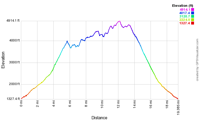
Click the link below to download a .GPX file with a track of this hike.
Details
Climbing the infamous 60-foot Shuckstack Fire Tower, gently swaying in the wind, had been on my list for years before the historic tower's construction deteriorates to the point where it is no longer safe to scale. However, I didn't want to just hike out and back to the tower and kept debating what route incorporating Shuckstack I would enjoy the most. That's when the half-insane idea of combining Shuckstack and Gregory Bald in one day hike popped into my mind. It would make for a perfect loop, traversing some of the least-visited segments of the park around Doe Knob, with fairly diverse scenery between the Twentymile stream valley and the two vista points. It had been years since I'd completed a mountain day hike this long, but as I now know, this is actually quite a reasonable hike as long as you're in strong fitness shape and have completed comparable elevation gain in a day before.
Start out the hike along the Twentymile Trail, which follows a double-track forest road behind the metal gate. A sign denotes that it is five miles to the Appalachian Trail. The pleasant Twentymile Trail starts out essentially level as it parallels Twentymile Creek, with occasional glimpses of the creek's shoals through the trees. At 0.6 miles, cross a broad wooden footbridge across scenic Moore Springs Branch and arrive at the start of the Twentymile Loop Trail and Wolf Ridge Trail. This is where the loop section of our hike begins too; you'll be descending from Gregory Bald via the Wolf Ridge Trail, but for now, if you choose to hike the loop counter-clockwise like I did, you'll want to stay right on the Twentymile Trail toward Shuckstack. One-tenth mile farther, a signed spur trail bears right and leads to Twentymile Cascades in a couple hundred feet. The cascades, while not a real waterfall, are scenic and worth the quick side trip to see. Back on the main trail, you'll find that the same broad old roadbed alongside the creek continues, now gaining elevation at a slightly more noticeable rate. The trail crosses Twentymile Creek thrice via broad wooden footbridges at 1.6, 1.8 miles, and 1.9 miles. In between the second and third bridge is Campsite 93, a nice site in close proximity to the creek. At 2.3 miles, cross the fourth bridge over Twentymile Creek - this crossing is particularly scenic with a nice set of cascades and slides. The fifth and final bridge crossing occurs at 2.5 miles, after which the trail veers away from the creek and ascends moderately up a draw. Reach an important trail junction in Proctor Field Gap at 3.3 miles. The Twentymile Loop Trail bears left and reaches Wolf Ridge Trail at Moore Springs Branch again in 2.9 miles - this is a wonderful, moderate loop for folks wanting a half-day outing with plenty of nice creek scenery and serene forest. Straight ahead is the Long Hungry Ridge Trail, which reaches the Gregory Bald Trail in 4.6 miles, fording Twentymile Creek twice along the way. Long Hungry Ridge is a lesser-used trail that serves as a quicker access to Gregory Bald and shortens this loop by several miles, but you would completely miss out on Shuckstack. Therefore, to hike the full loop, turn right to stay on the Twentymile Trail. 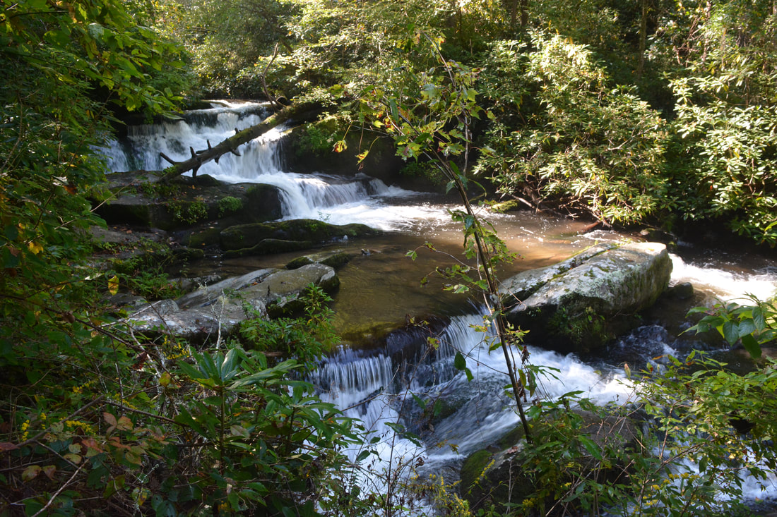
Twentymile Creek Cascades aren't big but quite scenic.
The hiking becomes decidedly more strenuous following Proctor Field Gap. The ascent is moderate to steep at times, along mostly dry, rocky trail without much to see along the way. The summit of Shuckstack peeks through the trees on your right (more noticeable in winter). Two fauna interactions provided me much-needed breathers along this leg of the ascent: first, a barred owl perched at a standstill in a tree - what a treat it was to see this specimen in broad daylight! And second, higher up the trail, a large rat snake had coiled up alongside the trail, providing me an opportunity to observe it and snap a few photos.
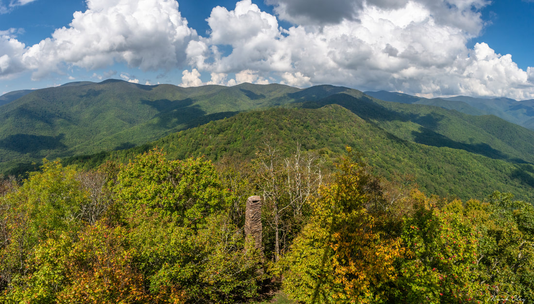
Arrive at the junction with the Appalachian Trail in Sassafras Gap at 5.3 miles. You've climbed over 2,300 feet to get to this point. The Appalachian Trail runs left and right, while the Lost Cove Trail plunges downhill straight ahead toward Fontana Lake. While the main loop will follow the northbound Appalachian Trail to the left, you'll want to turn right on the AT (southbound) first to visit the Shuckstack tower. The Appalachian Trail continues a gentle ascent out of the gap, as you must ascend another 350 feet to reach the tower. The main trail actually initially bypasses the summit, contouring along the slopes just below it. At a broad ridge-top opening at 5.6 miles, turn left onto the unmarked but well-trodden side trail to Shuckstack. After one final steep scramble up some rock outcrops, reach the Shuckstack summit at 5.7 miles. On the left is a concrete foundation and well-preserved rock chimney, remains from the tower-watcher's cabin. To the right, meanwhile, is the rickety fire tower itself, towering into the sky. The summit of Shuckstack is forested so you'll have to climb at least partway up the tower to get any views. The top of the Shuckstack fire tower is a wooden, glass-enclosed cab with stunning 360-degree views. To the southeast is the vast fingery expanse of Fontana Lake, along with Fontana Dam, the tallest dam east of the Rocky Mountains. Further south beyond the lake are the Yellow Mountains, with Cheoah Bald on the horizon. To the east, north, and west is the Smokies' vast expanse of lush green wilderness. Gregory Bald is the highest point to the north-northwest. Rocky Top and Thunderhead Mountain can be seen in the distance to the northeast. In my personal opinion, the view would be nicer if the cab was an open observation deck, but it's still incredible. You may also swing the glass windows open if you wish. 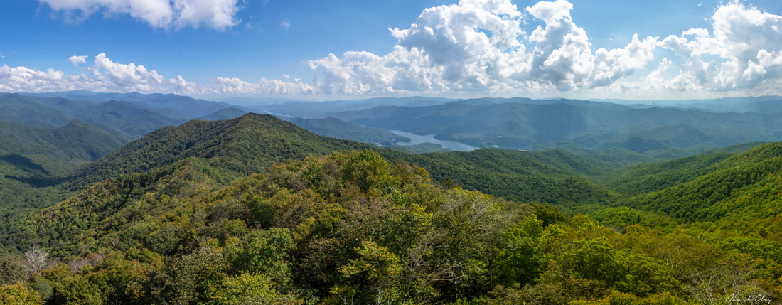
Shuckstack Tower provides fantastic panoramic views of the Smokies, Yellow Mountains, and Fontana Lake
After you've fully taken in Shuckstack Tower's view, return along the AT to Sassafras Gap, a pleasant downhill that is all but too short. The climbing resumes in earnest as you pick up the white-blazed Appalachian Trail northbound. Unlike the moderate but relentless ascent along the Twentymile Trail, this part of the hike features steeper grades combined with intermittent downhills, as the trail more or less ascends a ridge towards Doe Knob. After crossing several knobs, the trail steeply drops into Red Ridge Gap at 6.75 miles, crosses another knob, and reaches Birch Spring Gap at 7.1 miles. A side trail on the left leads westward 0.1 mile to Campsite 113, located by a spring at the head of an unnamed stream that is part of the Twentymile Creek watershed.
Past Birch Spring Gap, the Appalachian Trail makes a steep 400-foot ascent that tops out at 7.5 miles. After meandering along the ridge for a bit, where there must be nice seasonal views, the trail begins another steep ascent up Greer Knob at 7.9 miles; however, the trail avoids the summit and actually becomes easier as the trail turns westward to contour along the slopes. Reach another gap on the other side of Greer Knob at 8.7 miles - another ascent follows, but it is graded easy. Throughout this time, the hardwood forest remains largely similar, and there are likely lots of good views southwestward in winter. Finally, at 9.3 miles, the Appalachian Trail reaches a junction with the Gregory Bald Trail on the west side of 4520-foot Doe Knob. This loop continues with a left turn onto the Gregory Bald Trail, leaving the AT which continues in the direction of Spence Field and Thunderhead Mountain. From here on, the Gregory Bald closely follows or parallels the Tennessee/North Carolina state line. Compared to the superhighway that is the Appalachian Trail, traveled by thousands of folks every year, the Gregory Bald Trail will feel like a very little-traveled and forsaken trail. Its remote location makes the section between Doe Knob and Rich Gap in particular one of the least-hiked trails in the park, the faint footpath often hardly visible in the fairly open hardwood forest. Another characterizing element of the Gregory Bald Trail is the countless knobs it crosses, leading to constant ascents and descents, but nevertheless, it is actually my favorite part of the hike. The trail first drops into Buck Gap just 200 feet past the junction before making an easy climb to Brier Lick Knob at 9.55 miles, slightly skirting the top. A very steep descent brings the trail to Brier Lick Gap at 9.75 miles. After this, the slim footpath edges to the south side of the ridge and contours along a steep slope featuring scenic woods with a distinct higher-elevation feel. Stark patches of galax and mountain laurel are intermixed with the hardwood forest. 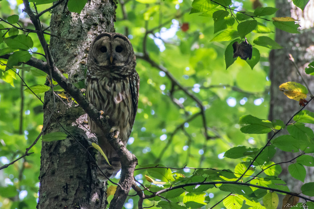
A barred owl provides a much-needed distraction while ascending the Twentymile Trail.
The trail crosses Cold Spring Gap at 10.2 miles, before making a 500-foot ascent that approaches the summit of a large but unnamed knob at 11.1 miles. Another descent brings the trail to the Long Hungry Ridge Trail junction at 11.25 miles - sounds familiar? This is the same trail that you saw at the Proctor Field Gap junction much earlier in the day! Just one-tenth of a mile farther, at 11.3 miles, reach Rich Gap. To the right is the Gregory Ridge Trail, which descends to Forge Creek Road into Cades Cove in 5.0 miles. The Gregory Ridge Trail is a much more popular access route to Gregory Bald, so the trail once again becomes heavily-used from here on. Continue straight along the Gregory Bald Trail as it begins yet another steep climb toward Gregory Bald itself. Your legs are likely to be getting worn out by now, but fortunately, the Gregory Bald climb is almost the last ascent of the hike - aside from a minor one to Parsons Bald a little later.
The climb to Gregory Bald consists of two sections with a brief level stretch around 11.7 miles. At 12.0 miles, the trail reaches the edge of the woods and arrives at a split as it starts moving into the open bald area. The left fork is the official trail to the summit, but the right fork is a well-used alternate path that provides beautiful easterly views and also leads to the top. Reach the summit of Gregory Bald at 12.15 miles. The grassy top provides stunning 360-degree views of both the Tennessee and North Carolina sides of the Smokies. To the north, the rolling meadows of Cades Cove are in plain sight, framed by Rich Mountain in the back with the lowlands of the Tennessee River valley extending to the horizon. To the south and east, the view is slightly more obstructed but still very beautiful. On this day, scattered thundershowers were crossing the Yellow Mountains and central Smokies, so I did not have great visibility in this direction. The summit of Gregory Bald is famed for its vast area of flame azalea bushes, which bloom a brilliant orange in June and attract hundreds of visitors. 4940-foot Gregory Bald is the highest point on this hike; what's more, nearly all of the hike onward is downhill, news that couldn't be more welcome at this point. You've still got over seven miles to go before you'll return to the Twentymile trailhead, but the hiking will be much quicker now. A moderate descent brings the trail to a three-way intersection at 12.6 miles. Here, the Gregory Bald Trail turns right and steeply descends 4.1 miles into Tennessee to one-way Parsons Branch Road. This used to be another popular access point for Gregory Bald, but Parsons Branch Road has been closed for quite some time as of this writing. Meanwhile, this hike bears left on the Wolf Ridge Trail, the route back to Twentymile. The fairly spacious Campsite 13 lies at the intersection and serves as a great basecamp for backpackers wishing to see the sunrise or sunset atop Gregory Bald. 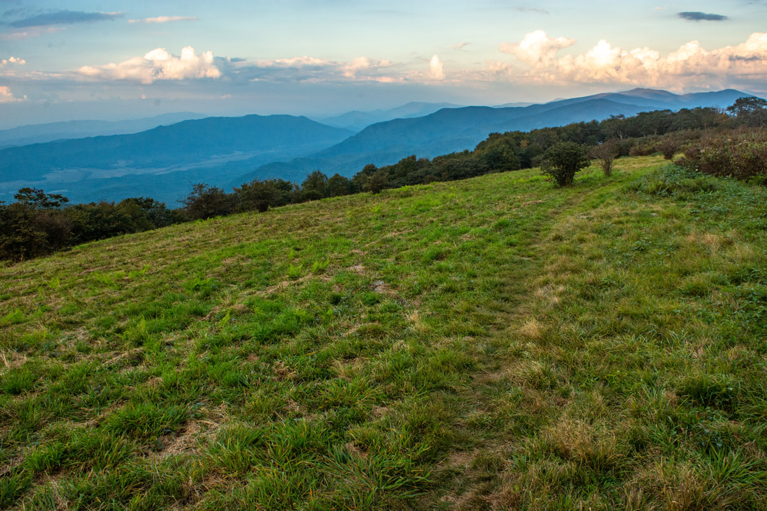
The meadows of Cades Cove are in plain sight from Gregory Bald's grassy summit.
Shortly after the junction, the Wolf Ridge Trail dips through Sheep Pen Gap and begins the final gentle climb to Parsons Bald. After a 150-foot ascent, the trail crosses the overgrown summit of Parsons Bald at 13.3 miles. Although this mountain is called a bald too, the summit open area is very narrow in comparison to Gregory Bald, and there are no views to be seen. After pushing through some bushes, the trail finally begins the lengthy descent into the Twentymile valley. This is where the trail officially leaves the state line, headed into North Carolina for good. There isn't much to say about the next 3.6 miles, especially since I hiked this section in darkness! The trail stays surprisingly obvious and well-defined though, and the descent - while monotonous at times - never gets steeper than moderate and has occasional switchbacks that should prevent it from burning your knees too much. A potentially confusing spot occurs at 14.5 miles, where the trail makes an acute right turn in a small opening. Having descended roughly 2,500 feet since the summit of Parsons Bald, the Wolf Ridge Trail arrives at a junction with the short side trail to Campsite 95 at 16.9 miles. As I was hurrying to wrap up the hike, I neglected to check out the campsite side trail, but I understand that it is a very nice site located right alongside the gurgling waters of Dalton Branch.
Turn left to stay on the Wolf Ridge Trail, which now follows a broader roadbed above the cascades of Dalton Branch. Some more downhill brings you to the junction with the Twentymile Loop Trail at 17.7 miles. Stay right on the double-track Fork Ridge Trail (in conjunction with the Twentymile Loop Trail, which also heads straight to Proctor Field Gap), and at 17.8 miles, reach two footlog crossings in quick succession - one of Dalton Branch and one of Moore Springs Branch. The trail crisscrosses Moore Springs Branch via footlogs four more times (with wade bypasses to be used by horses), and each of the elevated footlogs have wonderful views of this swift stream. It was a shame to be missing out on much of this scenery due to darkness, but it was my own fault that I started the hike so late with such a long drive from the Atlanta metro area into this corner of North Carolina. One thing I did notice about this section of the Wolf Ridge Trail in the darkness was that the footing was a bit uneven and rocky at times, despite the trail's width. At 18.8 miles, the Wolf Ridge Trail arrives at the Twentymile Trail, a sight for sore eyes, as you've finally closed this loop. Turn right and retrace the final 0.6 miles back to the parking area, reaching your vehicle at 19.4 miles. Bravo - you've just tackled both Shuckstack and Gregory Bald in one tremendous hike! Now, whether you end up doing this as a killer day hike or spreading it over a night or even two nights is entirely up to you. You're likely to have a fantastic time either way in one of the Smokies' lesser-visited and underappreciated corners. Mileage
0.0 - Twentymile Trailhead
0.6 - Start of loop 0.7 - Twentymile Creek Cascades 1.8 - Campsite 93 3.3 - Proctor Field Gap Jct (Twentymile Loop & Long Hungry Ridge Trl) 5.3 - Sassafras Gap Jct (Appalachian Trl & Lost Cove Trl) 5.7 - Shuckstack Fire Tower 6.1 - Sassafras Gap 7.1 - Birch Spring Gap (Campsite 113) 9.3 - Gregory Bald Trl Junction at Doe Knob 11.3 - Rich Gap Jct (Gregory Ridge Trl) 12.15 - Gregory Bald Summit 12.6 - Wolf Ridge Trail Junction and Campsite 13 13.3 - Parsons Bald 16.9 - Campsite 95 17.7 - Twentymile Loop Trl Junction near Moore Springs Branch 18.8 - End of loop 19.4 - Twentymile Trailhead Pictures & Videos
I somehow failed to take a video from the summit of Gregory Bald - my apologies. :(
0 Comments
Leave a Reply. |
About MeMark Oleg Ozboyd Dear readers: I have invested a tremendous amount of time and effort in this website and the Georgia Waterfalls Database the past five years. All of the work that has gone in keeping these websites updated with my latest trip reports has almost been like a full-time job. This has not allowed me to pick up a paid job to save up money for college, and therefore, I I've had to take out loans. If you find the information on this website interesting, helpful, or time-saving, you can say "thanks" and help me out by clicking the button above and making a contribution. I will be very grateful for any amount of support you give, as all of it will apply toward my college tuition. Thank you!

Coming in 2022-2023?
Other Hiking WebsitesMiles HikedYear 1: 540.0 Miles
Year 2: 552.3 Miles Year 3: 518.4 Miles Year 4: 482.4 Miles Year 5: 259.9 Miles Archives
March 2021
Categories
All
|
||
 RSS Feed