South Florida is best known for its sugar cane farms, swamps such as the Everglades, cities like Miami and Naples, and Lake Okeechobee. One of the more secret special places is a relatively little-known "hill" called Hobe Mountain - an ancient sand dune near Jupiter Island that rises to a height of 84 feet above sea level. In this mostly flat land, Hobe Mountain is a unique location, which has an observation tower that is most easily accessed using a short boardwalk in Jonathan Dickinson State Park. Jonathan Dickinson State Park itself is a mecca for outdoor recreation enthusiasts, as it has over two dozen miles of hiking trails, in addition to many other recreational opportunities. On this day, I first hiked the short trail to Hobe Mountain, before embarking on a much longer hike through the park. This hike occurred on Saturday, July 23rd, 2016. My plan was to hike the boardwalk out and back to Hobe Mountain and its observation tower.
2 Comments
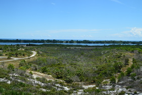
Catfish Creek State Park is in an area of Florida called the Lake Wales Ridge: a long elevated strip of land in central Florida with elevation peaking at 312 feet on Sugarloaf Mountain. Originally, the ridge was a series of "sand islands" over a million years ago, when most of the rest of Florida was actually underwater. Much of the Lake Wales Ridge has unaltered, conserved scrub habitat, which is essential for the areas dozens of endangered plants and animals, such as the sand skink, gopher tortoise, and scrub jay. On this hike, you'll scramble up to some of the region's highest hills, with their dazzling bright sand, as well as drop down into shady depressions where lakes abound. Additionally, you'll visit the site of an old sod farm and get to see some of the remaining structures - if they're still there by the time you're reading this. This hike occurred on Saturday, July 16th, 2016. My plan was to begin hiking the long loop counter-clockwise, before taking the medium loop connector across to the other side of the loop. From there, I would begin hiking the long loop in the clockwise direction, but not for long - I would then hike out and back the side trail to the sod farm ruins. After this, I would hike the long loop to the medium loop connector, and after hiking the connector for a second time, I would hike the remaining section of the long loop.
 Panthertown Valley is a mecca for outdoor recreation, with over a dozen waterfalls and many mountains that provide spectacular views. Some locations, such as Schoolhouse Falls and Little Green Mountain, are very popular. Other locations, such as Riding Ford Falls and Panthertail Mountain, are seldom visited or even heard of. On this hike, you will get to see as many as five waterfalls, with several others just a short ways off. Also, you'll visit two mountaintop vistas, with a third one nearby. Just make sure not to stray off too far on the unclear trail system on Panthertail Mountain, because you might have a long way back. This hike occurred on Saturday, May 28th, 2016. My plan was to begin this hike at Cold Mountain Gap, where I would take the Mac's Gap Trail to Greenland Creek. After hiking te short spur trail to Greenland Creek Falls, I would take the Greenland Creek Trail downstream along Greenland Creek, before turning onto an unofficial trail that led past Mac's Falls and Pothole Falls to Schoolhouse Falls. From Schoolhouse Falls, I would follow the Devil's Elbow Trail to its terminus at Shelton-Pisgah Trail, (with a short side trip to Riding Ford Falls along the way). Then, I would take the Shelton-Pisgah Trail across Shelton-Pisgah Mountain, before venturing onto a set of unofficial trails to Panthertail Mountain. From here, my plan was to return to Panthertown Valley by way of Little Green Creek, but things turned out otherwise, and I ended up following an unknown-to-me trail to Cold Mountain Gap Road.
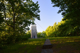
The Lake Russell trail system is often overlooked by hikers, who are interested in the "true" mountain hiking just a short drive to the north of Cornelia. The Lake Russell Recreation Area does not sit in the actual mountains, but these foothills provide quality hiking nonetheless. Several hiking trails can be found around Lake Russell and Nancytown Lake. On this hike, you will first see a couple of waterfalls on Nancytown Creek, before hiking along the shores of Nancytown Lake and then Russell Lake. The route becomes more difficult as the hike follows a seldom-used trail to the top of Chenocetah Mountain, where an old fire tower stands. Before your return to Nancytown Lake along a different trail, make sure to stop by the two clearings on Chenocetah Mountain that provide some views of Lake Russell and the distant Blue Ridge Mountains. This hike occurred on Saturday, May 7th, 2016. My plan was to hike several of the trails in the Lake Russell trail system. First, I would hike the Sourwood Trail. Then, I would take the Nancytown Lake Trail along the eastern shore of the lake, before connecting to the Lake Russell Loop and hiking the eastern and southern sides of the loop. From there, I would walk a short section of Lake Russell Road before taking the Campground Trail to the top of Chenocetah Mountain. I would return to Nancytown Lake using the Rhododendron Trail.
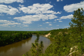
Located near the Apalachicola River, the Apalachicola Bluffs and Ravines Preserve protects one of the most unique habitats in Florida. The preserve has a number of steep ravines with streams flowing through them, and in fact, the preserve's hiking trail provides some of the biggest elevation changes to be found in the state. En route to the Apalachicola River, this hike passes through lush ravines as well as sandhill uplands with some longleaf pines. The highlight of the hike is at Alum Bluff. Positioned 135 feet above the Apalachicola River, this interesting geological formation provides a grand view of the river northward. The hike also makes a short loop through more ravines near the river and past additional sandy bluffs. This hike occurred on Sunday, April 24, 2016. My plan was to hike the Eden of Garden Trail out and back, At the far end of the trail, I would hike the short river loop counter-clockwise.

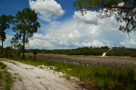
The coastal Florida Panhandle is well-known for its outstanding beaches. You have probably at least heard names such as Fort Walton Beach, Destin, and Panama City Beach. What most people don't know though is that not all of the beaches between Pensacola and Panama City are developed. A number of state parks, such as Topsail Hill State Park and St. Andrews State Park, are placed along the coast here to protect the fragile ecosystems that are found near the ocean. This part of Florida's coastline is home to fifteen coastal dune lakes - a very rare ecosystem that is found only in four other places: Oregon, Australia, Madagascar, and New Zealand. These lakes are one of the reasons that there is so much conserved land along the shoreline in Walton County. Out of the variety of state parks here, Topsail Hill State Park is the king of them all. This large park has several hiking trails that visit two dune lakes, a remote beach, and a landscape spotted with dunes of all shapes and sizes. This hike occurred on Tuesday, April 19, 2016. My plan was first to follow the paved Beach Tram Path to the Campbell Lake Bike Path, This is where I would take the south side of the Turpentine Trail past a view of Lake Campbell and then to the Deer Track Trail. I would follow the Deer Track Trail's south side to the Morris Lake Trail. After making a side trip to the beach, I would hike the Morris Lake Trail's loop counter-clockwise. Then, I would hike the Old Growth Trail, before hiking the Deer Track Trail's north side. I would finish the hike by following the north side of the Turpentine Trail.
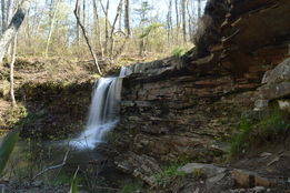
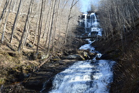
As one of Alabama's first state parks, DeSoto State Park was developed by the Civilian Conservation Corps during the 1930s, and much of their work can still be seen throughout the park today. Located on Lookout Mountain, the park is positioned on the west side of the West Fork of the Little River, conveniently close to the town of Fort Payne. A network of hiking trails visits as many as five waterfalls on tributaries of West Fork Little River. You will also see some views of the Little River gorge and some of the CCC's work on this moderate mountaintop hike. This hike occurred on Saturday, April 2nd, 2016. After completing a short hike to nearby De Soto Falls, I drove down to DeSoto State Park with a plan to make a loop out of several of the park's trail. First, I would take the Talmadge Butler Boardwalk to Azalea Cascade. Then, I would take the Azalea Cascade Trail to the Laurel Falls Trail. I would follow the Laurel Falls Trail to the Lost Falls Trailhead, making sure to make the side trips to Laurel Falls and Lost Falls. After the Lost Falls Trailhead, I would continue on a mountain bike trail that would take me past the CCC Museum and to the CCC Quarry. From the CCC Quarry, I would follow the CCC Quarry Trail to its terminus near the DeSoto State Park Visitor Center. After this, I would cross the park's Picnic and Play Area and follow an access trail to the DeSoto Scout Trail. I would follow the DST north for a little bit to the CCC Trail Shelter and views of the Little River, before turning south and finishing the hike at the park's lodge, passing Indian Falls and Lodge Falls in the meantime. A bit of roadwalk would be necessary to return back to the parking area.
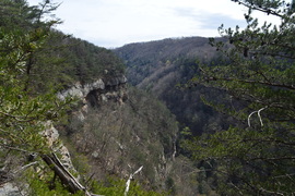
You have probably heard about Cloudland Canyon. Cloudland Canyon State Park's Sitton Gulch and Daniel Creek's waterfalls are known very well throughout the hiking community. The park's West Rim Trail is also known quite well. However, many hikers are not aware of another hiking trail in the park - and one that is much more secluded: the Bear Creek Backcountry Trail. The Bear Creek Trail passes through the Bear Creek gorge and then cruises over hills in the eastern section of the park, before reaching a fantastic vista of Cloudland Canyon. Unfortunately, as of March 21, 2016, the Bear Creek Backcountry Trail is closed east of Bear Creek indefinitely. This hike occurred on Saturday, March 19th, 2016. My plan was to check out the "tourist overlook" of Cloudland Canyon near the trailhead. From there, I would hike the Overlook Trail to the Bear Creek Backcountry Trail. Then, I would hike the entire Bear Creek Backcountry Trail - my plan was to hike the loop section counter-clockwise and then return the same way. On my way back, I planned to hike the park's Backcountry Loop clockwise.
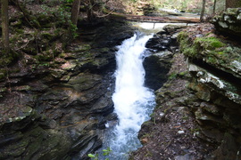
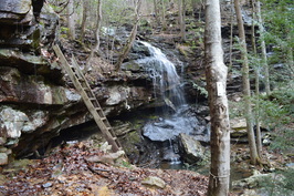
South Cumberland State Park is a state park with several tracts scattered throughout the south Cumberland Plateau in Grundy County, Franklin County, and Marion County. Two of these tracts - Grundy Forest State Natural Area and Foster Falls TVA Small Wild Area - serve as the starting and ending point for a dozen-mile long trail that is known as the Fiery Gizzard Trail. The Fiery Gizzard Trail has gained the reputation of being one of the most difficult trails in Tennessee, as it traverses several rocky gorges with rugged terrain. Backpacker Magazine has ranked the Fiery Gizzard Trail in its top 25 hiking trails throughout the US due to the beauty of the gorges encountered on this trail. On this hike, you're going to follow a route that will take you past several waterfalls on Little Fiery Gizzard Creek and Fiery Gizzard Creek before embarking on a very rugged scramble through the gorge. Then, you will ascend out of the gorge to a couple of panoramic vistas of the Fiery Gizzard gorge, before returning to the Grundy Forest Day Loop and seeing more waterfalls on Big Fiery Gizzard Creek. This hike occurred on Saturday, March 12th, 2016. My plan was to first hike the eastern section of Grundy Forest Day Loop. Then, I planned to take the Fiery Gizzard Trail south through the Fiery Gizzard Creek gorge to Raven Point. After visiting Raven Point, I would take the Dog Hole Trail back to the Fiery Gizzard Trail near Grundy Forest Day Loop. I would finish the hike by taking the western half of the Grundy Forest Day Loop.
729-foot Amicalola Falls is famous for being the highest waterfall in Georgia. Nestled in Amicalola Falls State Park, the falls attracts a crowd of tourists all throughout the year. A network of hiking trails and pathways is positioned around the falls and both to the west and east of it. For those seeking a more intimidating hike that relatively has some solitude, the park has two trails that head out into nearby Chattahoochee National Forest. The Hike Inn Trail leads to a lodge that is accessible only by foot five miles from the park, while the AT Approach Trail acts as the access trail to Springer Mountain - the southern terminus of the Appalachian Trail. You'll be treated to continuous winter views and several year-round viewpoints on both trails. This hike occurred on Saturday, March 4, 2016. My plan was to take the AT Approach Trail from the Visitor Center past Amicalola Falls and to the Hike Inn parking area and trailhead. From there, I would take the Hike Inn Trail to the Len Foote Hike Inn and then to the AT Approach Trail near Amicalola Mountain. Then, I would take the AT Approach Trail to Springer Mountain. I would return to the Hike Inn Trailhead using solely the AT Approach Trail. From the Hike In Trailhead, I would take East Ridge Trail to the Visitor Center.
The Unicoi Mountains straddle the Tennessee/North Carolina border in the Cherohala Skyway area. Bob Bald is one of the higher mountains in the range. At an elevation of 5294 feet, Bob Bald provides extensive views of the Citico Creek Wilderness and Joyce Kilmer-Slickrock Wilderness. There are several different ways to reach Bob Bald, but the easiest one is from Beech Gap on the Cherohala Skyway. You will first follow an abandoned forest road along the State Line Ridge, before taking off onto a singletrack trail that leads straight to Bob Bald. This hike occurred on Saturday, February 27, 2016. My plan was to hike closed Forest Road 217H from Beech Gap to the Bob Bald Connector Trail. From there, I would take the Bob Bald Connector Trail to the summit of Bob Bald. After visiting Bob Bald, I would return the same way.
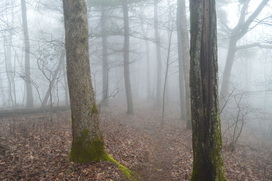
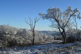
Vogel State Park is nestled in a small north Georgia valley in the middle of Chattahoochee National Forest near Blood Mountain. The park is home to several hiking trails, including the Coosa Backcountry Trail, a well-known hiking trail that traverses two mountains in its dozen-mile course. On this hike, you will climb to a small vista of the valley in which Vogel State Park lies, before approaching Slaughter Bald and bagging Coosa Bald. This hike is especially good in winter, as much of the hike traverses ridges and slopes with great views when the trees are bare - as long as it is not foggy. This foggy hike occurred on Saturday, February 20, 2016. My plan was to hike the northern and eastern section of the Bear Hair Gap Loop and most of the Coosa Backcountry Trail.
Jones Gap State Park: Pinnacle Pass Trail and Rim of the Gap Trail, Cleveland, South Carolina5/2/2016 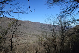
When someone mentions Jones Gap, you may think they're referring to a low point on some sort of ridge... just like you would imagine with any other Gap. Jones Gap is actually the name of a deep depression, the Saluda River valley, that is located in the extreme northern tier of Greenville County, South Carolina. The Mountain Bridge Wilderness provides many hiking opportunities throughout the Jones Gap area. On this particular hike, you will ascend out of Jones Gap past seasonal views for a loop that circles along the south rim of the gap. This hike occurred on Saturday, February 13, 2016. My plan was to hike a short stretch of the Jones Gap Trail, and then to hike the Pinnacle Pass Loop by hiking the Pinnacle Pass Trail and the eastern half of the Rim of the Gap Trail.
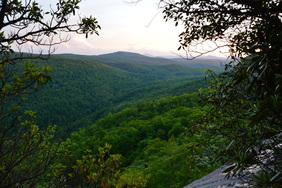
 If there ever was a hike that you must absolutely not miss, no matter where you have hiked or are planning to hike, then this is it. As my personal favorite hike on the Cumberland Trail (at least to this date), this is one segment of the famous long-distance trail that has just about everything that you can find on the Cumberland Plateau, from tall bluff lines that stretch on for miles, to spectacular vistas of one of the area's most picturesque gorges, Chickamauga Gulch, to remote waterfalls set in some of the best settings I've yet to see in this area. This is truly one spectacular hike by all means. This hike occurred on Saturday, January 16th, 2016. My plan was to hike the Cumberland Trail from the trailhead on Montlake Road to Panther Branch Overlook. However, due to time-consuming photography of the countless points of interest on this hike, as well as to the extremely rugged and slow nature of the latter part of the hike, I was only able to reach Stevenson Branch Falls. That was okay with me, however, as I have hiked the excellent section of the Cumberland Trail north of Stevenson Branch Falls, and the section to the south, that I hiked on this day, proved to be even more spectacular.
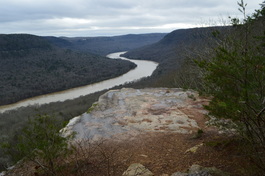 The Tennessee River is Tennessee's grand river. Near the city of Chattanooga, the river carves a passage through a deep gorge before becoming Nickajack Lake. On this hike atop a finger of the Cumberland Plateau that juts out into the Tennessee River Gorge, you will see several vistas of the river, a bizarre geological formation called the Natural Bridge, and a number of wet-weather waterfalls - they really are invisible, unless you happen to hike the trail in the middle or after a notable flooding event. Expect quite a workout curving throughout countless hollows before arriving at Ransom Hollow Overlook, one of the best vistas on the southern Cumberland Plateau. This hike occurred on Saturday, December 26th, 2015. My plan was to hike the Pot Point Loop clockwise from the Snoopers Rock Trailhead.
|
About MeMark Oleg Ozboyd Dear readers: I have invested a tremendous amount of time and effort in this website and the Georgia Waterfalls Database the past five years. All of the work that has gone in keeping these websites updated with my latest trip reports has almost been like a full-time job. This has not allowed me to pick up a paid job to save up money for college, and therefore, I I've had to take out loans. If you find the information on this website interesting, helpful, or time-saving, you can say "thanks" and help me out by clicking the button above and making a contribution. I will be very grateful for any amount of support you give, as all of it will apply toward my college tuition. Thank you!

Coming in 2022-2023?
Other Hiking WebsitesMiles HikedYear 1: 540.0 Miles
Year 2: 552.3 Miles Year 3: 518.4 Miles Year 4: 482.4 Miles Year 5: 259.9 Miles Archives
March 2021
Categories
All
|
 RSS Feed