HIKING THE APPALACHIANS AND BEYOND
  • Home
  • Trail Reports
    • Best Hikes
    • Hikes with Scenic Views
    • Hikes with Water Features
    • Alabama
    • Georgia
    • Florida
    • North Carolina
    • South Carolina
    • Tennessee
    • Vermont
    • Virginia
  • Map
  • Hike List
  • Testimonials
  • Resources
  • Contact Us
  • Southeast Nature Society
    • Our Team
  • Georgia Waterfalls Database

Chattahoochee National Forest: Talley Mill Creek Falls, Clayton, Georgia

3/29/2017

0 Comments

 
Picture
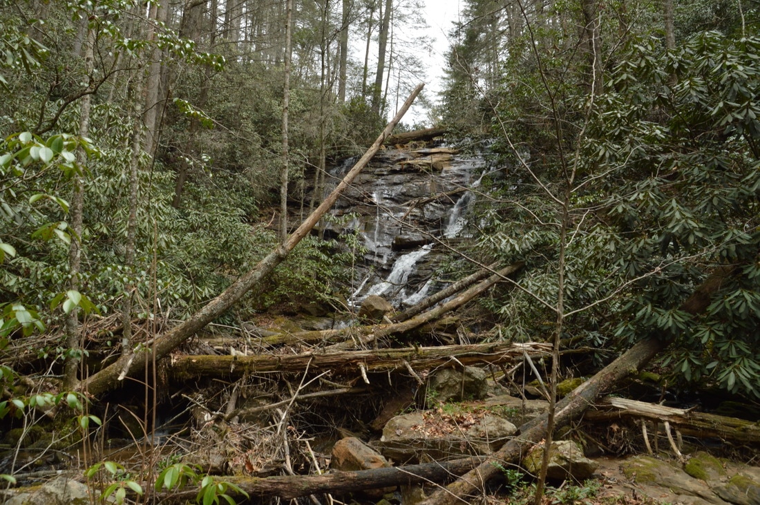
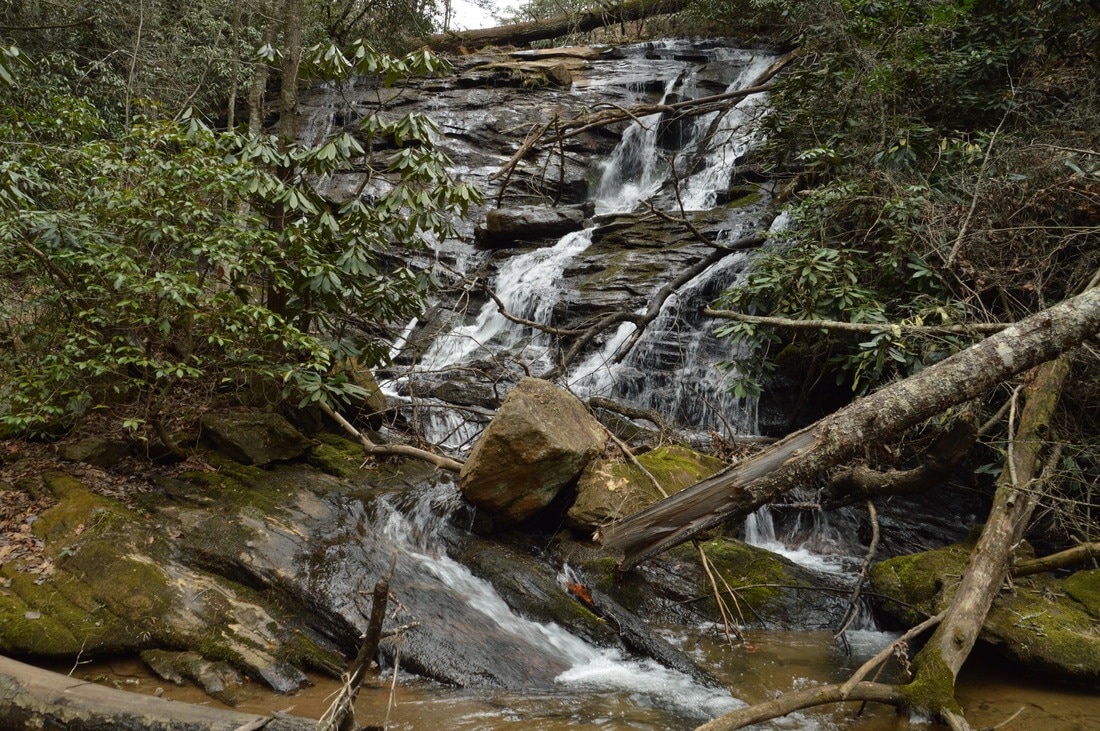
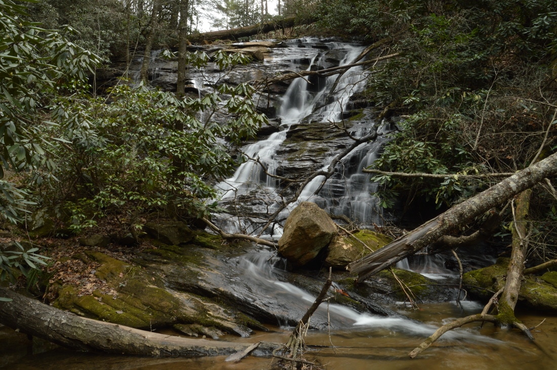
A major tributary of Big Creek, Talley Mill Creek originates just across the state line near Highlands and flows into Georgia through mostly private land. However, in the final course of its run, south of Highway 28, the creek enters National Forest land and forms a beautiful waterfall that cascades 45 feet down a steep rock ledge. The falls is surprisingly little-visited and not well-known in the hiking community, despite its proximity to the road and ease of access. In fact, an old logging road leads almost all of the way to the waterfall, and a faint path created by occasional previous hikers serves as the final leg of the hike. This hike occurred on Saturday, March 11th, 2017. My plan was to hike out and back to Talley Mill Creek Falls from Highway 28, following the route of least resistance (which turned out to be very easy to find). 

Summary

R/T Length of Trail: 0.5 Miles
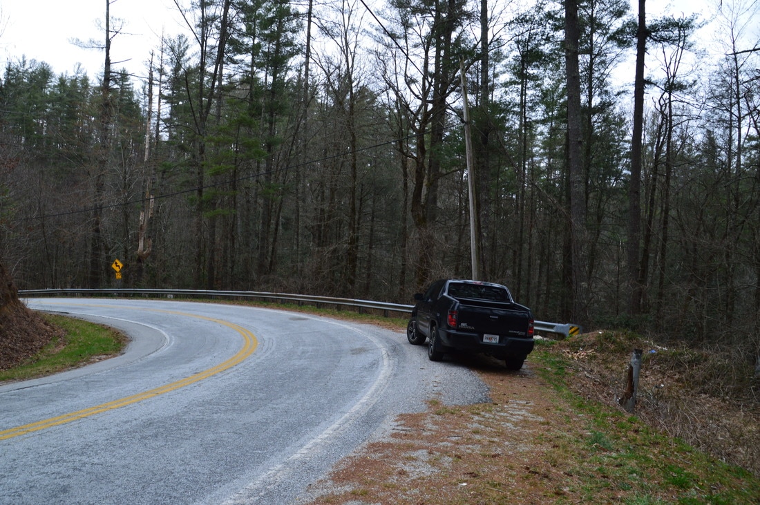
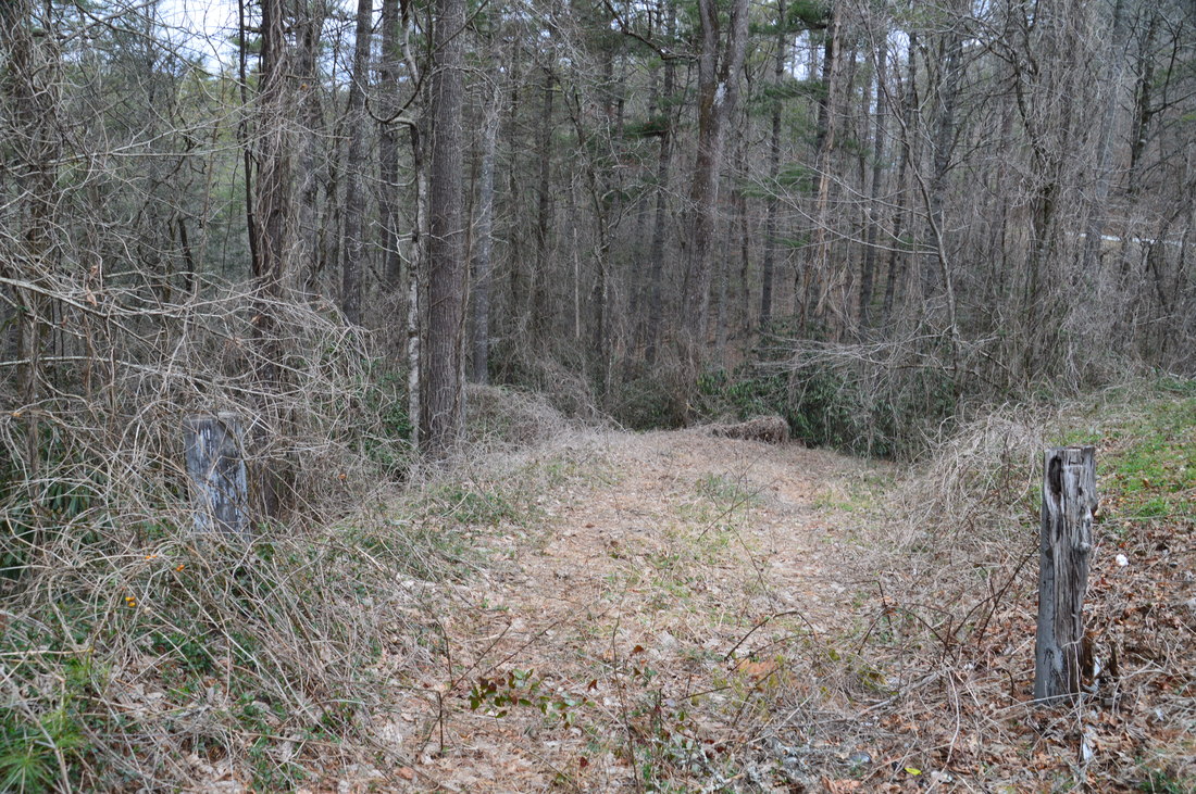
Duration of Hike: 0:40 
Type of Hike: Out and Back 
Difficulty Rating: 1 out of 10 
Total Elevation Gain: 106 Feet 
Pros: None 
Cons: There is a locals' trash dump at trailhead as well as other trashy places throughout the hike
Points of Interest: Sliding Waterfall on Talley Mill Creek - 2 stars (with adequate water); Talley Mill Creek Falls - 4 stars
Trail Blaze Colors: None 
Best Seasons to Hike: Winter, Spring 
Fees: None 
Beginning Point: Outside bend on Highway 28 
Directions from Clayton, GA: From the intersection of Rickman Drive and US 23/441 in downtown Clayton, follow Rickman Drive East. In 0.5 miles, turn diagonally right onto Warwoman Road, and continue for 13.4 miles. At the T-intersection with GA 28, turn acutely left onto GA 28 and continue for 4.9 miles to an outside bend in the road, where the trailhead is. The spot is easy to miss, but it can be identified by the end of a guardrail and two wooden posts that mark the entrance to an old forest road. There is space for two or maybe three cars in front of the trailhead. The trailhead is located 0.7 miles north of the bridge across Big Creek. 

Map

Picture
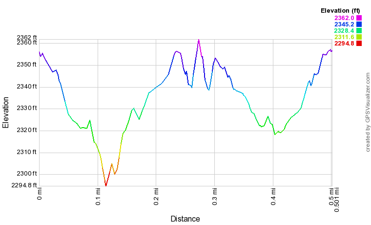
Click here to download a track of this hike. 

Details

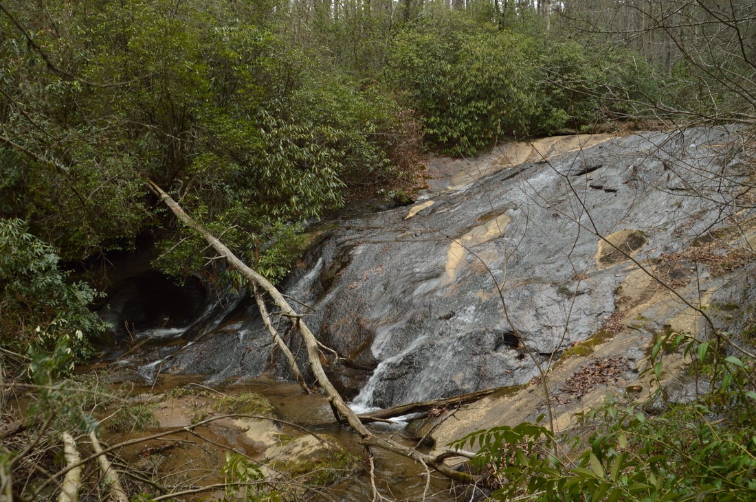
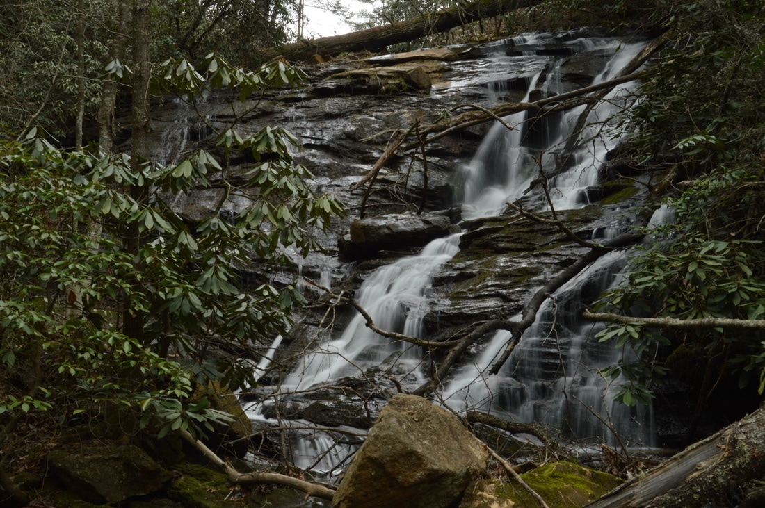
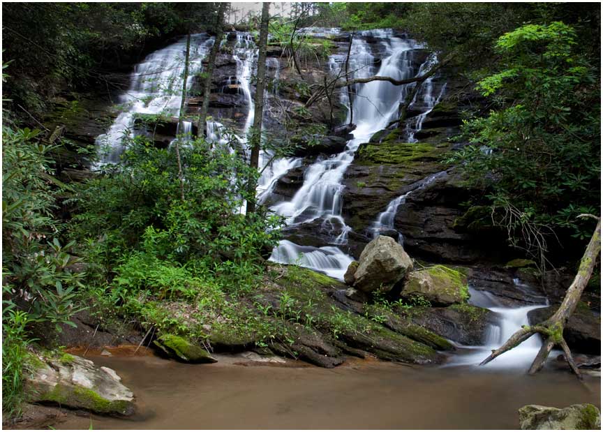
Ever since I found out about a large waterfall on Talley Mill Creek from a couple of friends, I have wanted to visit it, and I found the perfect opportunity to do so before a much longer hike to Three Forks on the same day. What I didn't realize is just how much water is needed to make Talley Mill Creek Falls look good. Folks, this is always a nice waterfall at normal summer flow (or during winter drought flow like on this day), but a visit during normal winter/spring flow or after a heavy rain is necessary to truly appreciate the beauty of Talley Mill Creek Falls. Still, it is always worth a stop to look at. 

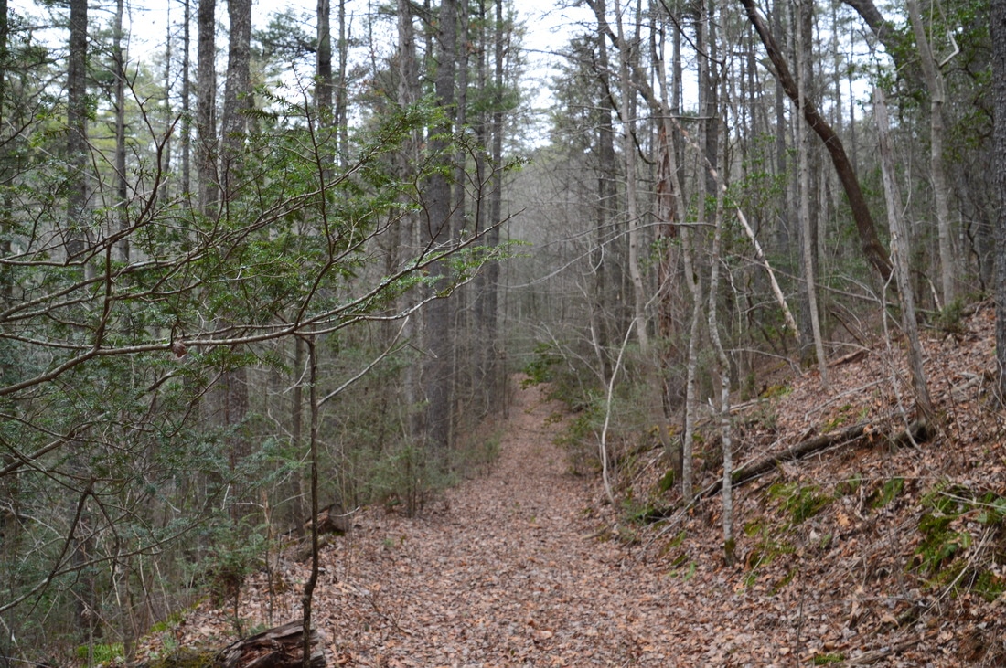
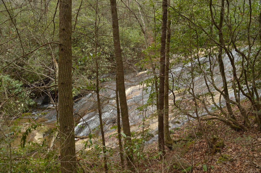
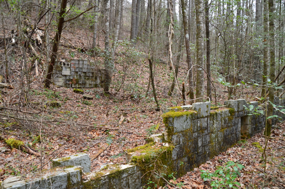
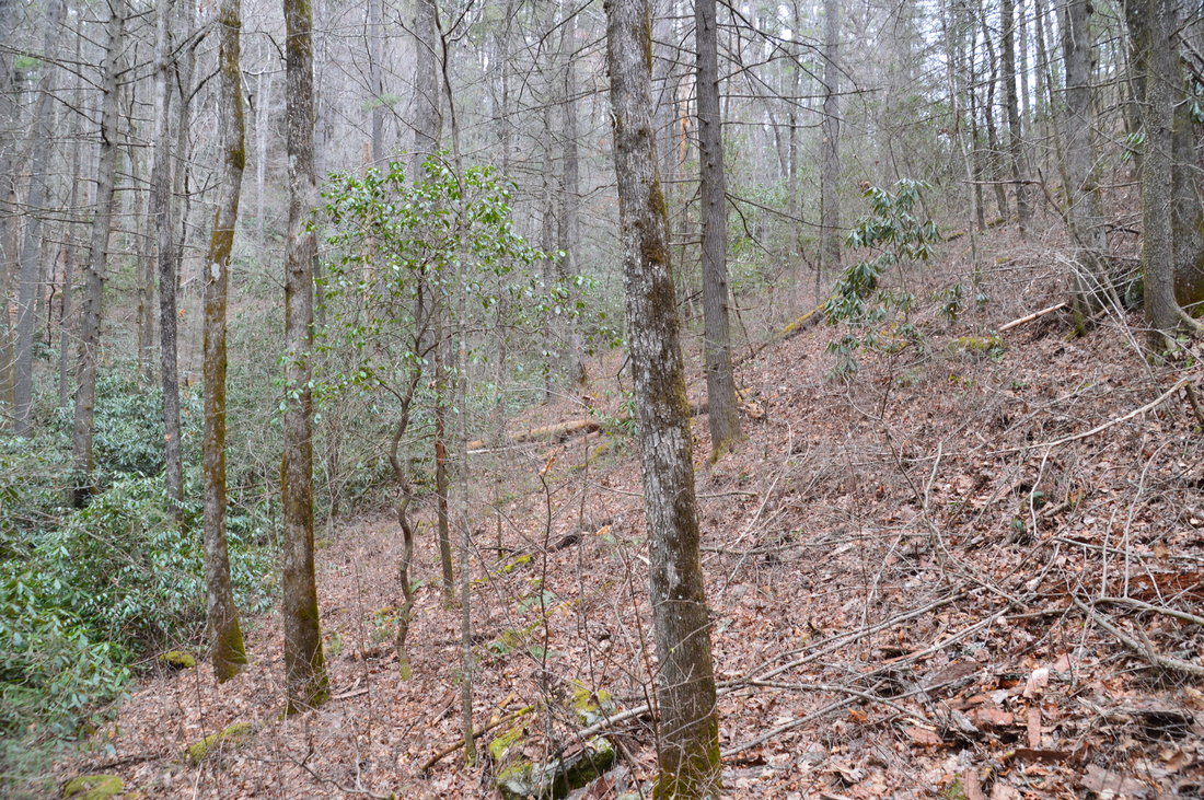
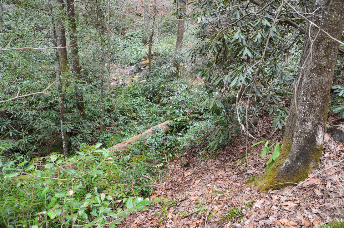
The hike begins at an old logging road that leaves Highway 28 at an outside bend. The logging road is marked by a pair of wooden posts (one on each side). Unfortunately, there is a large trash dump at the trailhead and on the slope just below it to the left of the road. The logging road is easily followed, but the beginning could be a bit overgrown in summer. After a gentle downhill, you can see a sliding waterfall on Talley Mill Creek down to the left at 0.1 miles. An indistinct 100-foot side trail leaves left down to the creek to the sliding waterfall. The view from the side of the creek is impeded by vegetation, so for the best view, you must scramble up a large log that stretches across the creek (you don't have to walk very far along it, though!). At today's low flow, the waterfall featured a wide sloping wet rock with several ribbons of water flowing across. During higher flow, I suspect that this could be a more photogenic waterfall. One element of interest is a sort of tiny rock shelter on the far side of the slide and creek (it kindof looks like it may have originally been a pothole?). 

Return to the old logging road at about 0.15 miles and continue following it north-northwestward. At 0.2 miles, the logging road appears to end in a turnaround near the creek. There are some ruins of stone walls to the right, and a bit farther ahead, an abandoned structure that resembles the remains of a mobile home. My best guess is that this area used to be private and the Forest Service bought it, as it is clearly National Forest land now, suitable for public use. Regardless, pass to the left of the abandoned building and pick up a phantom path that heads north and upstream above the creek into steepening terrain. The woods are open, so even if you cannot make out the path, just follow the route of least resistance. At around 0.25 miles, the slope becomes steep ahead, impeding any further progress. Talley Mill Creek Falls is audible but is not yet seen well. To reach the falls, turn left onto a downhill path that shortly ends up at creek level. The short path requires a brief walk through a semi-thicket of rhododendrons, but the biggest obstacle is a huge tree that is fallen across the path on the steepest part of the slope. On your way back up, scrambling over the log is going to be quite a challenge, and it may possibly be better to crawl under the log, although that option is perhaps even more unattractive, even if it is easier. 

Once you reach the creek, turn right and walk, rock hop, and wade upstream to the base of Talley Mill Creek Falls, reaching it at 0.27 miles. Talley Mill Creek Falls is about 45 feet high. The creek spills down a tall cliff with many small rock outcrops. At low water, most of the water spills down the right-hand side of the cliff and into a shallow pool near the base. During high water, the waterfall becomes much more photogenic (and potentially deserves a higher beauty rating), as water spills down the cliff in many ribbons all over the rock outcrops. Thus, at high water, the waterfall becomes much wider, as the whole wide cliff becomes involved. I have included Jack Anthony's picture of Talley Mill Creek Falls at high water for reference in the gallery at the bottom of this page, as I myself have only seen the falls at low water. 

Please note: the west side of Talley Mill Creek in the vicinity of the waterfall is private land. While taking your pictures of the falls and while viewing it, it is acceptable to stand in the middle of the creek, but please do not cross over to the west (left-hand) bank of the creek, as that will be considered as trespassing. 

From Talley Mill Creek Falls, simply retrace your steps back to the trailhead, concluding the hike at 0.5 miles. 

Mileage

0.0 - Talley Mill Creek Trailhead
0.12 - Sliding Waterfall on Talley Mill Creek
0.2 - Ruins and logging road end 
0.27 - Talley Mill Creek Falls 
0.5 - Talley Mill Creek Trailhead

Variations

None

Bonus Stops

For a longer hike after this short leg-stretcher, consider hiking to Three Forks via the Big Creek Trail from Highway 28, passing many spectacular waterfalls. In fact, I did that hike on this day after Talley Mill Creek Falls. Many other  hiking options are available just across the state line to the north near Highlands, including Sunset Rock and Secret Falls. 

Pictures

Videos

0 Comments


Leave a Reply.

    About Me

    Mark Oleg Ozboyd
    I'm an avid outdoor explorer and a hobbyist landscape photographer. I'm 21 years old and have been hiking since 2011. Originally based out of Atlanta, Georgia, I started out by occasionally hiking short trails throughout well-known Georgia State Parks. During 2012 and 2013, I began to expand my trips into adjacent states, as well as into the wilder National Forest areas rather than just State Parks. Throughout the years that followed, as I slowly ran out of popular hiking trails in my area, I began to search for and hike in more seldom-visited areas. Today, you can find me out in the woods every weekend, whether it's on an official trail or bushwhacking through cross-country terrain without any paths. I now attend Washington & Lee University and am exploring Virginia and West Virginia. My other hobbies include chess, science, old music, and meteorology. I have 3 years of amateur weather forecasting experience, having studied a lot of meteorology basics over the years. I am also a student at European School of Music where I learned that music and nature have a lot in common. Listening to good music inspires me to capture nature's beauty on the camera in different aspects that also make me recall many beautiful music pieces that I've heard.​


    Dear readers: I have invested a tremendous amount of time and effort in this website and the Georgia Waterfalls Database the past five years. All of the work that has gone in keeping these websites updated with my latest trip reports has almost been like a full-time job. This has not allowed me to pick up a paid job to save up money for college, and therefore, I I've had to take out loans. If you find the information on this website interesting, helpful, or time-saving, you can say "thanks" and help me out by clicking the button above and making a contribution. I will be very grateful for any amount of support you give, as all of it will apply toward my college tuition. Thank you! 

    Enter your email address to subscribe for trail reports:

    Delivered by FeedBurner


    Picture
    Coming in 2022-2023?

    Other Hiking Websites

    DWHike's Adventures
    Florida's Natural Wonders
    Florida Trailblazer
    Meanderthals
    Mountain Images
    by Bernie Boyer

    North Carolina Waterfalls with
    ​Kevin Adams
    Take-a-Hike!
    Tennessee Landforms
    Waterfall Page
    Waterfall Adventurer
    Zach's Mild Adventures

    Miles Hiked

    Year 1: 540.0 Miles
    Year 2: 552.3 Miles
    ​Year 3: 518.4 Miles
    Year 4: 482.4 Miles
    Year 5: 259.9 Miles

    Archives

    March 2021
    February 2021
    January 2021
    November 2019
    October 2019
    September 2019
    August 2019
    July 2019
    June 2019
    February 2019
    January 2019
    December 2018
    November 2018
    October 2018
    August 2018
    July 2018
    June 2018
    May 2018
    April 2018
    March 2018
    February 2018
    January 2018
    December 2017
    November 2017
    October 2017
    September 2017
    August 2017
    July 2017
    June 2017
    May 2017
    April 2017
    March 2017
    February 2017
    January 2017
    December 2016
    November 2016
    October 2016
    September 2016
    August 2016
    June 2016
    May 2016
    April 2016
    March 2016
    January 2016
    December 2015
    November 2015
    October 2015
    September 2015
    August 2015
    July 2015
    June 2015
    May 2015
    April 2015
    March 2015
    February 2015
    January 2015
    December 2014
    November 2014
    October 2014
    September 2014
    August 2014
    July 2014
    June 2014
    May 2014
    April 2014
    March 2014
    February 2014

    Categories

    All
    Adel
    Adirondack Park
    Alabama
    Alfred A. Ring Park
    Allegheny Trail
    Amicalola Falls State Park
    Anniston Area
    Apalachicola Bluffs And Ravines Preserve
    Apalachicola National Forest
    Apalachicola/Port St. Joe Area
    Apopka
    Appalachian Trail
    Appling
    Art Loeb Trail
    Aska Trail System
    Bakersville
    Balm-Boyette Scrub Preserve
    Balsam Lake Recreation Area
    Bankhead National Forest
    Bartow County Parks
    Bartram Trail
    Basinger
    Beersheba Springs
    Benton
    Benton Mackaye Trail
    Berry College Trail System
    Best Hike
    Big South Fork National Recreation Area
    Black Bear Wilderness
    Black Rock Mountain State Park
    Blairsville
    Blakely
    Blood Mountain Wilderness
    Blowing Rock
    Blue Ridge
    Blue Ridge Parkway
    Boone
    Bradenton
    Bradenton Beach
    Brasstown Bald
    Brasstown Wilderness
    Brevard
    Bryson City
    Buchanan
    Bucks Pocket State Park
    Bulow Creek State Park
    Bulow Plantation Ruins State Park
    Caesars Head State Park
    Caladesi Island State Park
    Calhoun
    Camel's Hump State Park
    Cashiers
    Caspersen Beach Park
    Catfish Creek State Park
    Caves
    CC Putnam State Forest
    Cedar Point Environmental Park
    Chatsworth
    Chattahoochee National Forest
    Chattanooga
    Chattanooga Valley
    Chattooga National Wild And Scenic River
    Cheaha Wilderness
    Cherohala Skyway
    Cherokee
    Cherokee National Forest
    Chiefland Area
    Chillhowee Recreation Area
    Chipley
    Chunky Gal Trail
    Circle B Bar Reserve
    Citico Creek Wilderness
    Citrus Wildlife Management Area
    Clarkesville
    Clayton
    Cleevland
    Cleveland
    Cloudland Canyon State Park
    Cohutta Wilderness
    Collier-Seminole State Park
    Cordele
    Cornelia
    Covington
    Crestview Area
    Crew-land-and-water-trust
    Cullowhee
    Cumberland Trail
    Dahlonega
    Dalton
    Dawson Forest Wildlife Management Area
    Dawsonville
    Dayton
    De Soto National Memorial
    DeSoto State Park
    Dillard
    Double Springs
    Ducktown
    Duncan Ridge Trail
    Dunlap
    Eagle's Rest Park
    Eastpoint
    Econfina Creek Wildife Management Area
    Eglin Air Force Base
    Elizabethton
    Elkins
    Elk Knob Game Lands
    Elk Park
    Ellicott Rock Wilderness
    Ellijay
    Emerson Point Preserve
    Englewood Area
    Enota Retreat
    Erwin
    Falling Waters State Park
    Fayetteville
    Fires Creek Recreation Area
    Fire Tower
    Flint River
    Florence Area
    Florida
    Florida Caverns State Park
    Florida Trail
    Foothills Trail
    Fort Mountain State Park
    Fort Myers Area
    Fort Payne
    Fort Payne Area
    Fort Yargo State Park
    Franklin
    Franklin Delano Roosevelt State Park
    Franklin-Marion State Forest
    Frozen Head State Park
    Gainesville
    Gainesville Area
    Gatlinburg
    George Washington National Forest
    Georgia
    Georgia Veterans Memorial State Park
    Glasgow
    Gorges State Park
    Grandfather Mountain State Park
    Great Smoky Mountains National Park
    Greeneville
    Green River Game Lands
    Gruetli-Laager
    Grundy Forest State Natural Area
    GTM Reserve
    Guana River Wildlife Management Area
    Hayesville
    Helen
    Hiawassee
    High Falls State Park
    Highlands
    Highlands Scenic Highway
    Hillsborough River State Park
    Hinson Conservation & Recreation Area
    Historic Sites
    Honeymoon Island State Park
    Hot Springs
    Huntington
    Inverness Area
    Jackson
    Jasper
    Jefferson National Forest
    Joan M. Durante Park
    Jonathan Dickinson State Park
    Jones Gap State Park
    Joyce Kilmer Slickrock Wilderness
    Joyce Kilmer - Slickrock Wilderness
    Juniper Prairie Wilderness
    Kelly Park
    Keown Falls Recreation Area
    Kolomoki Mounds State Park
    LaFayette
    Lake City Area
    Lake George Wild Forest
    Lake June-in-Winter State Park
    Lakeland Area
    Lake Placid
    Lake Russell Wildlife Management Area
    Lake Wales Ridge State Forest
    Laurel Fork North Wilderness
    Leffis Key Preserve
    Leon Sinks Geological Area
    Lexington
    Lineville
    Linville
    Linville Gorge Wilderness
    Lithia Springs
    Little Frog Wilderness
    Little Manatee River State Park
    Little River Canyon National Preserve
    Longboat Key
    Long Trail
    Lookout Mountain
    Lookout Mountain Battlefield
    Lovingston
    Lula Lake Land Trust
    Lumpkin
    Maggie Valley
    Manatee Springs State Park
    Marianna Area
    Mark Trail Wilderness
    Marlinton
    Mccaysville
    McMinville
    Mentone
    Middlesex
    Mistletoe State Park
    Monongahela National Forest
    Montreat
    Mountain Bridge Wilderness Area
    Mountain City
    Mountains To Sea Trail
    Mountains-to-Sea Trail
    Mount Rogers National Recreation Area
    Myakka River State Park
    Myron B. Hodge City Park
    Nantahala National Forest
    Naples
    Naples Area
    Natural Bridge State Park
    Neal Preserve
    New Castle
    Newport
    New River Gorge National Park
    New York
    North Carolina
    Ocala Area
    Ocala National Forest
    Ocean-to-Lake Trail
    Oconee State Park
    Oconee Station Historic Site
    Okaloacoochee Slough State Forest
    Oldsmar
    Oneida
    Orlando Area
    Ormond Beach
    Oscar Scherer State Park
    Oxford
    Palatka
    Palmetto Trail
    Panama City Area
    Panthertown Valley
    Parrish
    Paynes Creek Historic State Park
    Peaks Of Otter Recreation Area
    Pigeon Crockford Mountain Wildlife Management Area
    Pigeon-Crockford Mountain Wildlife Management Area
    Pigeon-Crockford Wildlife Management Area
    Pine Mountain
    Pinhoti Trail
    Pinnacle Park
    Pisgah Civitan Park
    Pisgah National Forest
    Pittman Center
    Pond Mountain Wilderness
    Ponds/Lakes
    Prentice Cooper State Forest
    Providence Canyon State Park
    Pumpkintown
    Quick Point Nature Preserve
    Raven Cliffs Wilderness
    Reed Bingham State Park
    Reliance
    Rice Creek Conservation Area
    Riverview Pointe Preserve
    Robbinsville
    Robinson Preserve
    Rock Creek Gorge Scenic Area
    Rock Island State Park
    Rome
    Rosman
    Sale Creek
    Salem
    Salt Springs
    Saluda
    Santa Rosa Beach
    Sarasota
    Sarasota Area
    Savage Gulf State Natural Area
    Scenic Views
    Scottsboro Area
    Sebring Area
    Sewanee
    Sheltowee Trace Trail
    Shining Rock Wilderness
    Signal Mountain
    Sipsey Wilderness
    Sky Valley
    Smithgall Woods State Park
    Snowbird Backcountry Area
    Soddy Daisy
    Soddy-Daisy
    Sopchoppy
    South Carolina
    South Cumberland State Park
    Southeastern Cave Conservancy
    Southern Nantahala Wilderness
    Sparta
    Sprewell Bluff Park
    Spring City
    Spring Hill
    Springs
    Spruce Pine
    Standing Indian Backcountry Area
    St. Augustine
    St. George Island State Park
    St. Joseph Bay State Buffer Preserve
    St. Marks Area
    St. Marks National Wildlife Refuge
    Stone Mountain
    Stone Mountain Park
    Suches
    Sumatra
    Sumter National Forest
    Suwannee River
    Swallow Creek Wildlife Management Area
    Sweetwater Creek State Park
    Sylva
    Talladega National Forest
    Tallahassee Area
    Tallulah Falls
    Tallulah Gorge State Park
    Tampa Bay Area
    Tate City
    Tate's Hell State Forest
    Tea Creek Wildlife Management Area
    Tellico Plains
    Tennessee
    Thomaston
    Toccoa
    Topsail Hill State Park
    Torreya State Park
    Townsend
    Tracy City
    Tray Mountain Wilderness
    Trenton
    Triple Creek Preserve
    Troutdale
    Unaka Mountain Wilderness
    Upper Tampa Bay County Park
    Venice
    Vermont
    Virgin Falls State Natural Area
    Virginia
    Virginia Outdoors Foundation
    Vogel State Park
    Wakulla Springs State Park
    Waleska
    Walhalla
    Wartburg
    Water Features
    Waynesville
    Weedon Island Preserve
    Weeki Wachee Preserve
    Wekiwa Springs State Park
    West Palm Beach Area
    West Virginia
    Whitehall
    White Springs
    Winder
    Withlacoochee State Forest
    Young Harris

    RSS Feed

TRAIL REPORTS

Hikes in Alabama
​Hikes in Florida
Hikes in Georgia
Hikes in North Carolina
Hikes in South Carolina
Hikes in Tennessee
Hikes in Virginia

Hiking Resources

Alabama Resources
​
Florida Resources
Georgia Resources
North Carolina Resources
​South Carolina Resources
​
Tennessee Resources

Other

Contact
Map of Hikes
Alphabetical List of Hikes
Southeast Nature Society
© COPYRIGHT 2014-2018
​ALL RIGHTS RESERVED.
Important: I disclaim any responsibility for any damage or personal injury that may occur as a result of the activities and information found on this website. All outdoor activities, especially off-trail hiking, are done at your own risk. Never hike or head into that area that may be above your fitness or experience level.
  • Home
  • Trail Reports
    • Best Hikes
    • Hikes with Scenic Views
    • Hikes with Water Features
    • Alabama
    • Georgia
    • Florida
    • North Carolina
    • South Carolina
    • Tennessee
    • Vermont
    • Virginia
  • Map
  • Hike List
  • Testimonials
  • Resources
  • Contact Us
  • Southeast Nature Society
    • Our Team
  • Georgia Waterfalls Database