Plumorchard Creek is one of a handful of mountain streams that drain the east side of the Tennessee Valley Divide and flow into the Tallulah River. Most of these streams quickly leave the mountaintops and are already in the valleys by the time they grow large. However, Plumorchard Creek is an exception. This stream tumbles 65 feet over a single-drop waterfall that flows down a steep cliff only a mile west of the Tallulah River. This hike occurred on Saturday, March 4th, 2017. My plan was to make an exploratory bushwhack from Plum Orchard Road to a location on Plumorchard Creek that I was highly confident in being home to an undocumented tall waterfall. As it turned out, the waterfall was there, and the hike was only a partial bushwhack (the first part followed gated forest roads).
Summary
R/T Length of Trail: 1.2 Miles
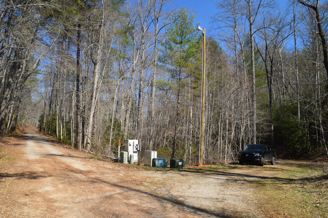
Duration of Hike: 2:35 (It took me a lot of time to scout out the best route, so it may take you less time since the route is established in this post, but this is still a time-consuming bushwhack despite the short distance) Type of Hike: Out and Back Difficulty Rating: 4 out of 10 Total Elevation Gain: 300 Feet Pros: Solitude and pristine setting at Angelica Falls Cons: Steep bushwhack and creekwalk in the hike's final segment Points of Interest: Angelica Falls - 10 stars Trail Blaze Colors: None Best Seasons to Hike: Spring (or Winter as long as you not mind the cold walk through water) Fees: None Beginning Point: Gated spur road off Plum Orchard Road Directions from Clayton, GA: From the intersection of US 23/441 and US 76 West in downtown Clayton, follow US 76 West (Savannah Street) for 8.0 miles, and then, turn right onto Persimmon Road. In 1.9 miles, turn left onto Plum Orchard Road. 2.7 miles from Persimmon Road, Plum Orchard Road becomes unpaved but it is in good condition and passable by most passenger vehicles. 3.5 miles from Plum Orchard Road, reach the trailhead area, which is characterized by a gated forest road leaving to the right. An assortment of electrical boxes are located at this spot. Park here but please do not block the gate, as the gated forest road is the main entryway to an area of private property along Plumorchard Creek above Angelica Falls. There is space for several cars, on both sides of Plum Orchard Road, without blocking the gate. Map
Click here for more information and to download this trail map to view in Garmin Basecamp.
Note: In the bushwhack section of the hike to Angelica Falls, I found a better and shorter route on my way back up than when I was going down. On the track above, the better route is further west while the one I originally took is further east. I describe the better route in this trail report but I also provide some details further down regarding why it is better. Details
During the first week of March, while browsing through satellite imagery across Rabun County, Georgia, I suddenly noticed an impressive waterfall - clearly outlined on satellite - in an unfamiliar to me part of Rabun County. A quick Google Search turned up exactly zero references to this waterfall, which appeared to be in Rabun County, and after spending a whole hour searching online and asking friends if they knew about this waterfall or had visited it, I concluded that the waterfall has not been "visited" by the hiking community (locals likely know about it, of course), and ultimately, it became that this spectacular waterfall on Plumorchard Creek is undocumented. I decided to visit it and was surprised to find the bushwhack shorter and easier than it had looked. After some contemplation, and after further increasing my confidence in the fact that the waterfall is unnamed and undocumented, I christened the 65-foot waterfall Angelica Falls, in honor of my mother. My opinion is that it is a very fitting tribute to the person who is behind instilling the love for waterfalls and nature as a whole in me.
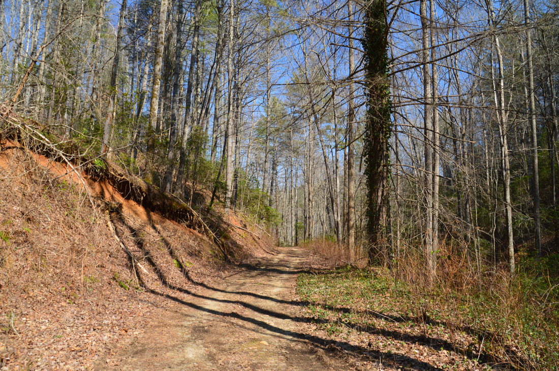
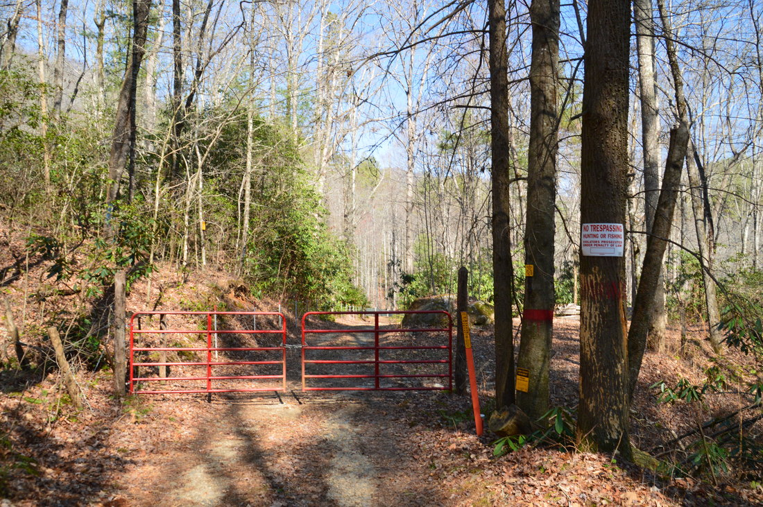
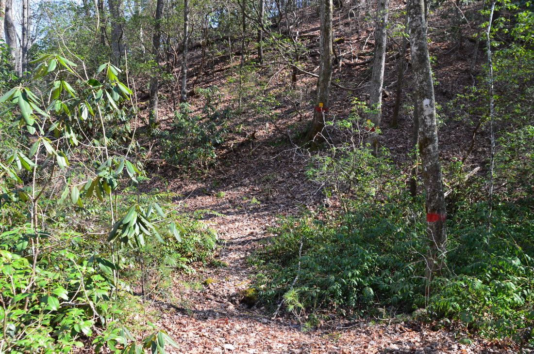
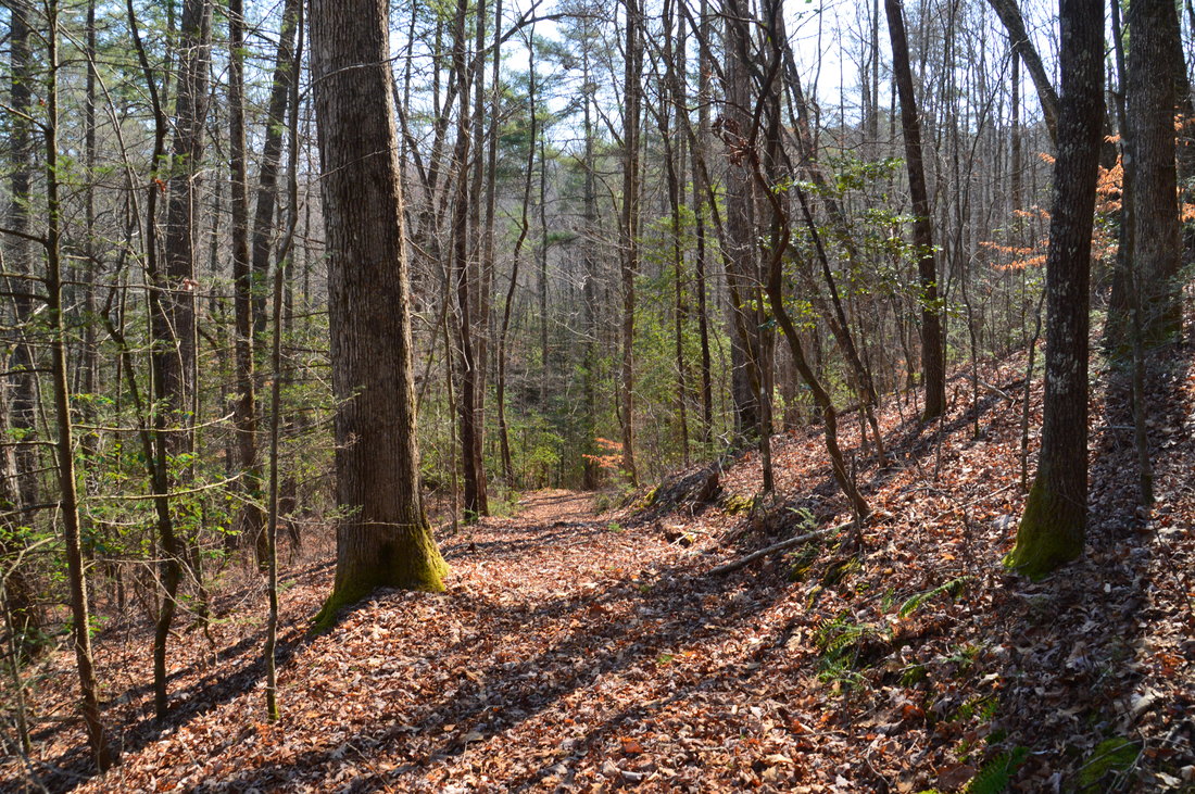
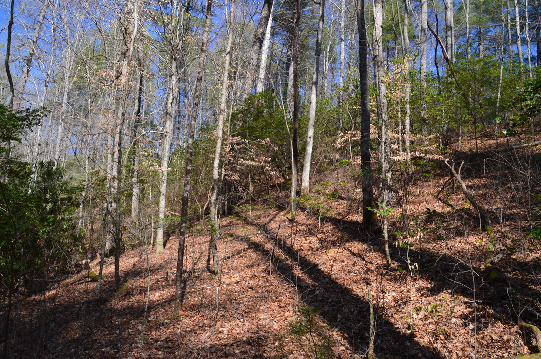
The hike to Angelica Falls is not difficult, but it is not on trails and requires a certain amount of navigational skills/experience, in addition to a map and compass (or GPS). One of the keys to the hike is to begin at the best starting point, which is described in the directions, but I will repeat it here. The trailhead is at a point where a gated road branches off to the right from Plum Orchard Road, and at the junction, there is a set of electrical boxes. The gated road is actually access to an area of private property near Plumorchard Creek, but it is perfectly fine to use the road to access Angelica Falls, because part of the road is on Forest Service property, and none of my hike nor my directions to the falls involved any trespassing. From the trailhead, walk around the gate at the beginning of the gated road and follow the wide road - which exhibits sign of usage - on a gentle downhill grade. 0.2 miles from the trailhead, reach a second gate and a profusion of signs related to private property. Do not follow the road beyond the gate under any circumstance; everything further down is private land. Instead, at the signs and surveyor's marker at the private property boundary, turn right onto a steep path past some sawed logs. Following the boundary, you'll pass through a small ravine and join an older forest road on the other side. Begin following the forest road eastward as it curves around a small lead from Russell Mountain. 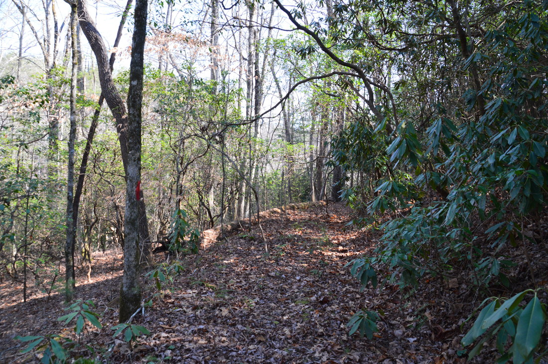
The first half of the hike to Angelica Falls is easy and follows forest roads.
As you follow the forest road, you'll curve away from the property boundary, but private fields will be visible several times in the valley below. The valley around Plumorchard Creek here is quite broad, and it is hard to imagine that the creek is about to go over a 65-foot drop and into a mile-long narrow gorge. At 0.25 miles, a steep path leaves left to the fields, and at 0.3 miles, an obvious forest road leaves acutely left to the fields as well. Continue straight on a not-as-well-defined forest road. The road suddenly disappears in what looks like it might be an overgrown turnaround at 0.35 miles. From here, the rest of the route to Angelica Falls is bushwhack, but the good news is that you are more than halfway there! To hike the best route to the falls, turn left into the relatively open woods and bushwhack northeast at a compass bearing of about 30° diagonally up a low ridge. There are some mountain laurel trees, but progress is relatively easy. At 0.4 miles, reach the crest of the low ridge. At the crest, turn left and work your way along the ridge to its end at the edge of the Plumorchard Creek gorge at 0.45 miles. At this point, I could hear Angelica Falls far below, and after beating around a bit, I found a point from which I could see the waterfall as well.
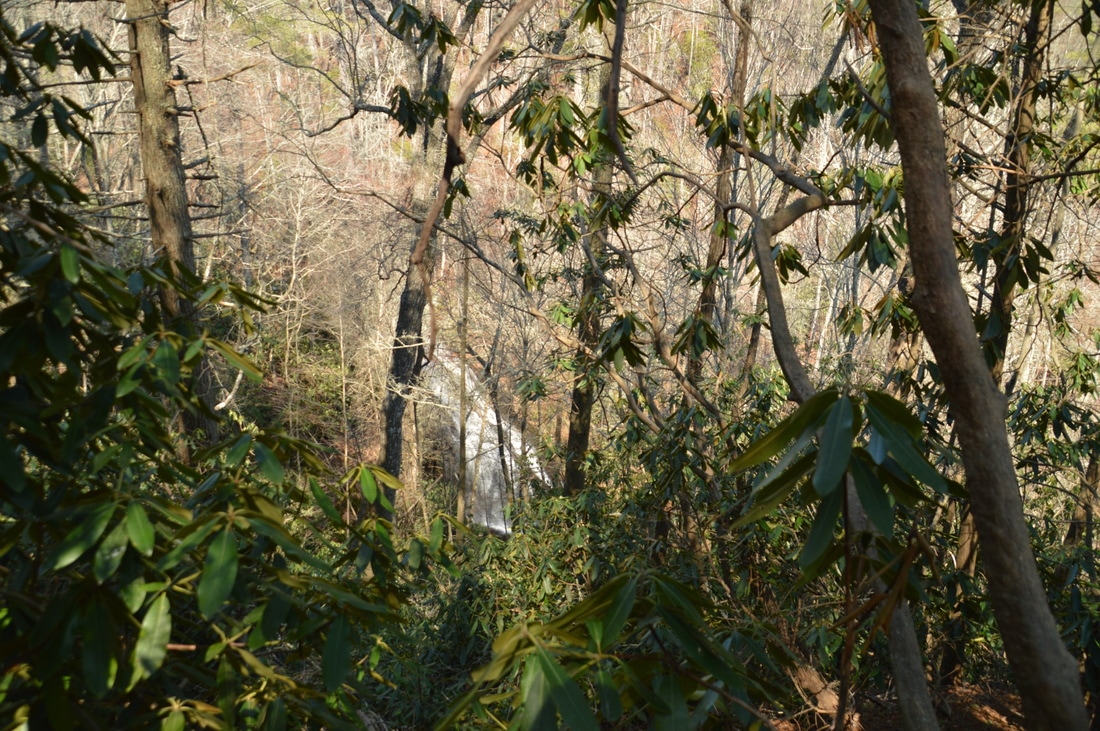
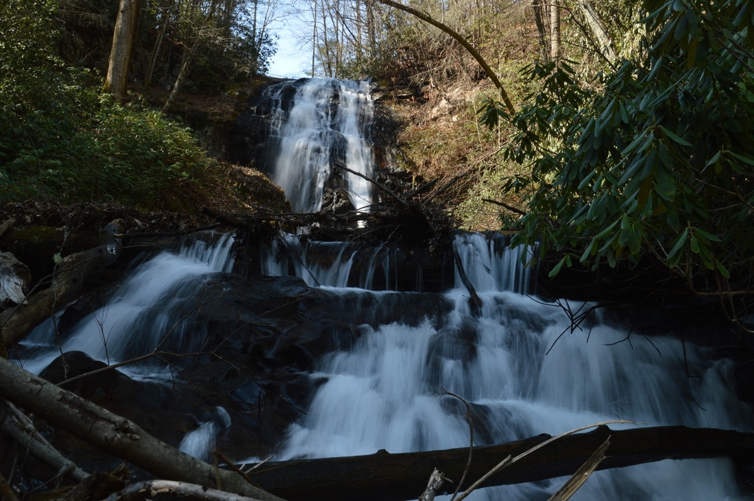
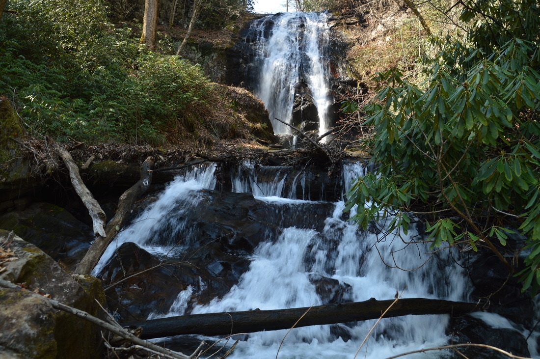
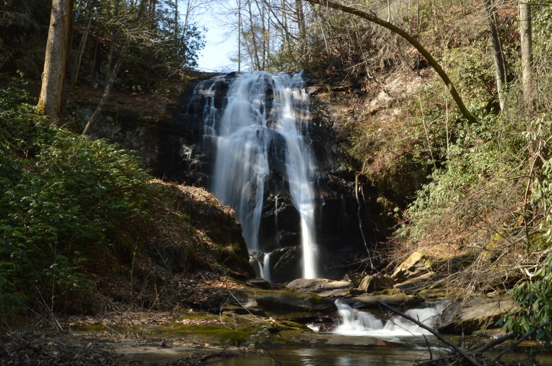
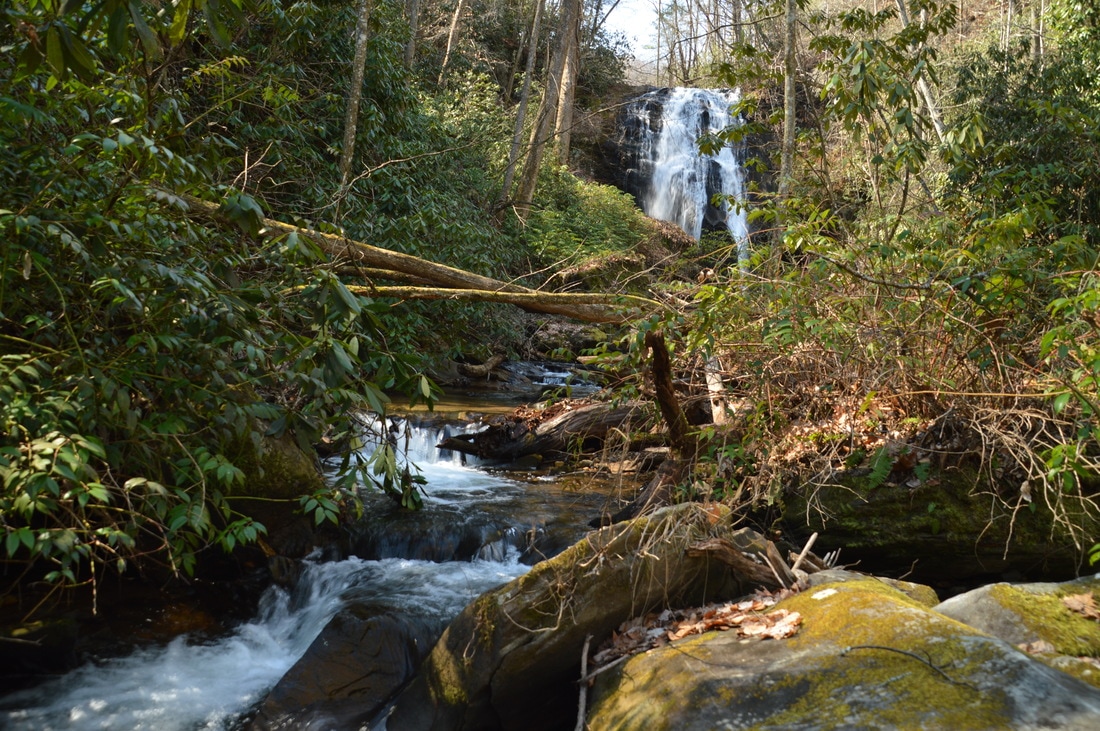
At the edge of the ridge is where my route in became different from my route back out. The route I recommend (which I utilized on my way out) is to descend the spine of the steep lead that heads northeast at a bearing of about 40° . While the lead is certainly steep, the understory is fairly open, allowing for relatively easy progress, and there are plenty of handholds that aid with the descent. The other option is to descend down the also steep and very open ridge-slope eastward into a ravine with a small feeder stream, and from there, to follow the feeder stream downstream to Plumorchard Creek, with a short but tough bushwhack through a rhododendron tangle along the way. In my opinion, the shorter route along the spine of the lead is easier, and assuming you took that route, you will come out at Plumorchard Creek in one tenth of a mile at 0.55 miles. During this time, you will descend about 200 feet. Once you reach Plumorchard Creek, there really is no sensible route other than to walk in the creek the rest of the way (about 250 feet) to the falls, as the sides of the creek are severely overgrown with rhododendron. Fortunately, walking in the creek is normally not difficult, although during high water it will be harder, and it may not be possible to do at all during cold weather. Begin walking upstream in the creek, which was no higher than knee level in the deepest places on this day (although it will be higher during a winter without drought). After ducking under a log, Angelica Falls comes into view through the bushes and trees, and even from the first glance, it becomes obvious that this waterfall is a classic Southern Appalachian beauty. Two-thirds of the way to the waterfall, there is an obstacle that could require a difficult bushwhack to get around during high water: a cascade that is several feet high. The best way to get up the cascade is on the left side, scrambling up a large log and onto boulders near the top of the cascade. After the cascade, several dozen more paces bring you to a second cascade and a large flat boulder. Angelica Falls is just ahead, and the view of it from here is perfect. For those who wish to get to the very base of the waterfall, getting around the second cascade is possible on the left side of the creek, but it would take significantly more time and effort, and in my opinion, the view from here is already very good. 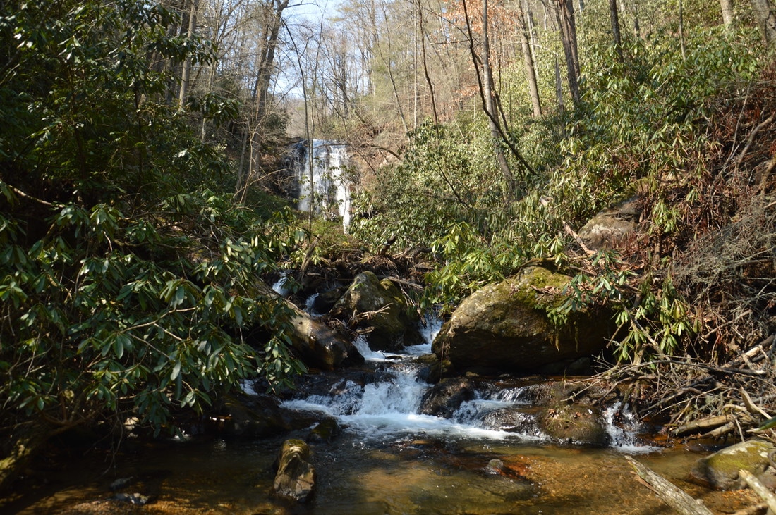
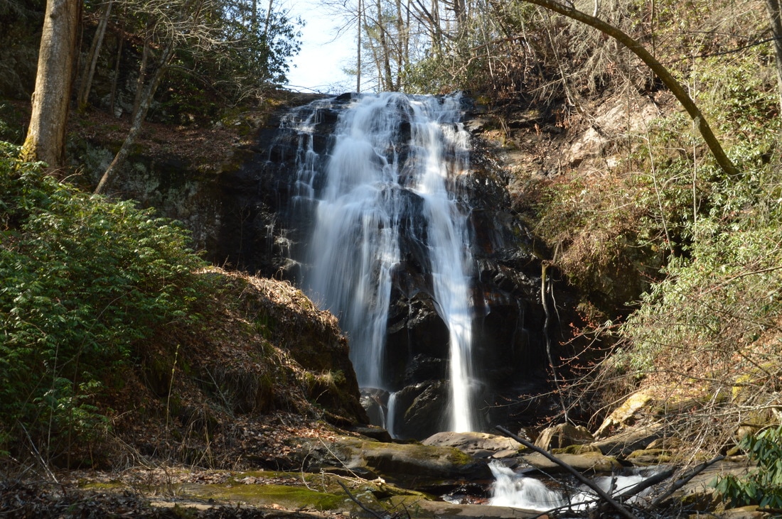
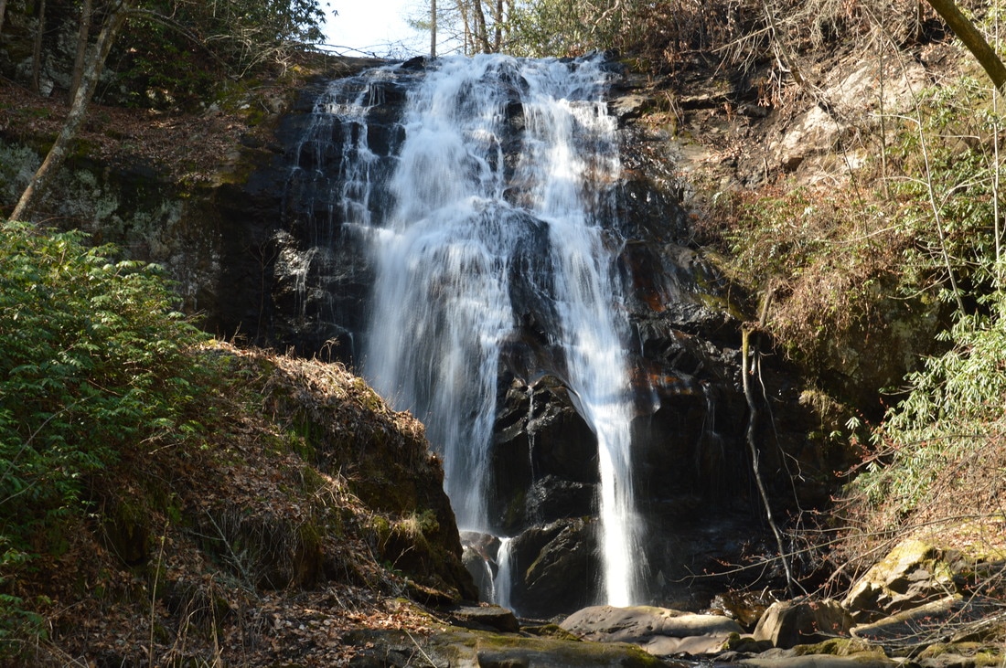
A quick and distant look at Angelica Falls reveals that this waterfall is undoubtedly a classic Southern Appalachian beauty.
Angelica Falls is 65 feet high, and all of it is in one drop down a nearly vertical cliff. During low water, the waterfall is still powerful, and two ribbons of water flow are exhibited (during high water, they likely converge into one). I could not see it well, but it seemed like there is a small rock shelter behind the waterfall near its base. It is interesting to note that closer to the base, the right side of the waterfall becomes more slanted than the left side, and an outcrop in the cliff separate the two sides at the bottom. Angelica Falls has become one of my favorite waterfalls in Georgia, and it is incredible that such a beauty has stayed "under the wraps" for so long. If you visit this beautiful waterfall on Plumorchard Creek yourself, please refer to it as Angelica Falls, as I am highly confident that the name I gave to it - Angelica Falls - is the first name to be assigned to the falls across the internet. In other words, some locals may have given their own names to it before, but there is no evidence of any prior names across the web.
After spending ample time for appreciating the beauty of Angelica Falls, simply retrace your steps back to the trailhead, concluding the hike at 1.2 miles. Mileage
0.0 - Plum Orchard Road Trailhead
0.2 - Private property boundary; turn right 0.35 - End of forest road 0.4 - Crest of ridge 0.45 - Edge of gorge 0.55 - Plumorchard Creek 0.6 - Angelica Falls 1.2 - Plum Orchard Road Trailhead Variations
None
Bonus Stops
Several short waterfall hikes are available nearby. Two of them are to Timpson Creek Falls and to two waterfalls on Moccasin Creek. In fact, I did both of these hikes in addition to Angelica Falls on the same day.
PicturesVideos
10 Comments
Charles
10/27/2017 07:48:09 pm
The last 1/3 of this hike is very difficult due to storm damage in Oct.
Alex
9/19/2018 10:49:29 am
Hi, is the damage bad enough that would you say the hike is not worth it? Many bushwacks I've attempted in the area since hurricane irma have been disappointing, since the storms have changed the entire landscape of the falls since Mark's trail reports were written.
C Amrine
6/2/2018 08:13:31 am
I have lived here since the mid 80s, got married and raised our children here. Most of the falls here are already named by long time residents going back many generations. Some may not be documented. You said you "christined" the falls Angelica Falls and to please start calling it by that name. Did you go through legal avenues to name this falls? Are you a local?
Kendall
12/22/2021 03:26:57 pm
There was a local uproar about this when it happened. He trespassed more than he stated. Obviously this wasn't an undiscovered waterfall and this Atlanta a**hole tried to legally name it. I would not suggest going on this "hike" as either way in you are trespassing and since this occurrence owners have set up cameras and will press charges.
Bill in Roswell
6/30/2018 06:47:22 pm
C Amrine, Mark gave the falls a name for reference purposes. There are local names to many geographic features - which is how most places got their names and why there seems to be a Rocky Mountain and Fall Creek Falls in every county in north Georgia. Unless someone turns in a place name to the USGS Board of Geographic Names to make the name official, local place names will not appear on maps. How is someone to know what the local name is when it's not on a map? Like many places known only to locals, most don't want the name on a map because then it will draw crowds. Thus the dilemma - locals call a place by one name, but outsiders call it by another. There is no harm done either way when a place doesn't have an "official" name, other than confusion for emergency workers (like during the Rock Mtn fire). If you want the falls in question to have the official local name, then go through the process to get it named on the National Map. You can post a name request here: https://geonames.usgs.gov/domestic/index.html
Mike M
10/8/2020 10:25:18 pm
I was there on 10/1 and couldn't find the steep path just before the private property gate. It was a total bushwhack up and over the hill. Was worth it in the end, but this is not easy to get to.
George
5/8/2022 08:48:29 am
RESPECT!! For local culture, local private land, local traditions!
James Sharp
6/13/2022 09:39:07 am
So...is one able to hike to this waterfall without risking a trip to jail or not?
Joseph A
6/20/2022 12:48:38 pm
I put the gps tracks on a map overlaid with public and private property lines and it seems that for almost the entirety of the hike, you're in the national forest. Theres one small section where he says to turn right that straddles the boundary and looks to go slightly into private land around where he hikes following the old forest road , but everything beyond that, including the falls themselves, all seem to be on public lands. Of course, don't take my word as absolute. Just do with that info what you will.
Kim R
1/12/2023 08:55:38 am
Joseph A., I just did the same thing to make sure for myself before I go. You are right. This entire hike is on public property. The small tract belonging to an individual is well outside the boundaries. Leave a Reply. |
About MeMark Oleg Ozboyd Dear readers: I have invested a tremendous amount of time and effort in this website and the Georgia Waterfalls Database the past five years. All of the work that has gone in keeping these websites updated with my latest trip reports has almost been like a full-time job. This has not allowed me to pick up a paid job to save up money for college, and therefore, I I've had to take out loans. If you find the information on this website interesting, helpful, or time-saving, you can say "thanks" and help me out by clicking the button above and making a contribution. I will be very grateful for any amount of support you give, as all of it will apply toward my college tuition. Thank you!

Coming in 2022-2023?
Other Hiking WebsitesMiles HikedYear 1: 540.0 Miles
Year 2: 552.3 Miles Year 3: 518.4 Miles Year 4: 482.4 Miles Year 5: 259.9 Miles Archives
March 2021
Categories
All
|


 RSS Feed