HIKING THE APPALACHIANS AND BEYOND
  • Home
  • Trail Reports
    • Best Hikes
    • Hikes with Scenic Views
    • Hikes with Water Features
    • Alabama
    • Georgia
    • Florida
    • North Carolina
    • South Carolina
    • Tennessee
    • Vermont
    • Virginia
  • Map
  • Hike List
  • Testimonials
  • Resources
  • Contact Us
  • Southeast Nature Society
    • Our Team
  • Georgia Waterfalls Database

Bartram Trail: Warwoman Dell to Pinnacle Knob, Clayton, Georgia

7/22/2014

9 Comments

 
Picture
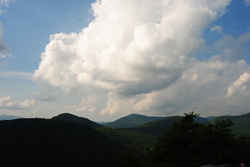
The Bartram Trail was created to extend from Northeast Georgia to Southwest North Carolina in the footsteps of the traveler William Bartram. His book, "The Travels of William Bartram", describes both his travels across the Southeast and the flora and fauna that he discovered in this area. In 1775, he visited a lush watery valley in Northeast Georgia now known as Warwoman Dell, from where he sent specimens of the flora and fauna to London. He was one of the first main explorers of the area. The section of the Bartram Trail described in this post is a section that is surprisingly short for as much as 3 attractions. This hike occurred on Saturday, July 12, 2014. The plan was to follow the Bartram Trail from Warwoman Dell by Becky Branch Falls and Martin Creek Falls to the Pinnacle Knob Trail.. From there, I would take the Pinnacle Knob Trail to the summit of Pinnacle Knob to be treated to what was in my opinion the best view I have seen yet in Georgia. 

R/T Length of Trail: 8 Miles
Duration of Hike: 4 Hours, 50 Minutes

Difficulty Rating: 7 out of 10
Pros: Two waterfalls; panoramic view; all stream crossings bridged; gradual ascent in many areas
Cons: Steep in the end
Best Season(s) to Hike: Winter; Early Spring
Trail Blaze Color(s): Bartram Trail - Yellow; Pinnacle Knob Trail - Green
Beginning Point: Warwoman Dell Receation Area Parking Area
Directions: From Clayton, GA: Drive east on Warwoman Road for 2.8 miles until you see the Warwoman Dell Recreation Area entrance on your right. Turn right onto the gravel road and park in either of the parking areas (one in the beginning and one near the end). 
Per my first visit to the Bartram Trail, I wasn't left with an exciting appearance considering the mistakes I did there. However, I knew that this time, it would be different. The section of the Bartram Trail near Warwoman Dell, while seldom traveled, has numerous rewarding features, and I am actually  surprised that I saw only one couple of hikers this day. 


There's a couple parking areas in Warwoman Dell; one near the beginning of the short gravel road and one at the picnic area. I parked in the latter, although the first one is right at the start of the trail. There is a trailside kiosk at the first parking lot with some information about the area. The Bartram Trail is marked by yellow blazes as it enters the woods on the north side of the road. There were a few switchbacks as it ascended to Warwoman Road.The trail crossed the road at 0.2 miles and started ascending more steeply towards Becky Branch and Becky Branch Falls. Along the way, I passed an old... pump station (?) on the left. That was my best bet as to what it was. At 0.5 miles, the trail leveled out and crossed Becky Branch at Becky Branch Falls. On this day, Becky Branch Falls was not very impressive with only fair amounts of water. After the falls, the trail started descending along the hillside towards Martin Creek. Around the 1-mile mark, the trail crossed an old forest road and continued downhill via switchbacks into a small stream valley. My map didn't have it. There was a small footbridge over it, and the trail continued descending. After leaving the small creek, the trail turned northward shortly and now started descending into the bigger Martin Creek valley. Yellow blazes were frequent, so losing the trail was unlikely in this area. The trail reached Martin Creek in an area of rapids, although the creek became quiet shortly. The Bartram Trail was flat following the creekside here. There were a couple tributary crossings too. The trail reached a camping area where you need to go straight, and then it crossed Martin Creek on a footbridge at 1.8 miles. The trail followed the east side of Martin Creek for 0.2 miles  passing a couple of rock outcrops. After that, it crossed Martin Creek on another footbridge (hint, hint - no wet feet!) and reached an observation deck for Martin Creek Falls at 2 miles. I liked Martin Creek Falls more than Becky Branch Falls. There was considerably more water flowing over the falls. 


At the observation deck, turn left onto an extension of the footbridge and then descend down the other bank of Martin Creek. Shortly, reach a camping area. I didn't waste time proving it, but I think that fi you walk a bit through the camping area, you can come out onto the Bartram Trail where you were earlier downstream. If it works, it saves time if you don't want to see Martin Creek Falls. After the camping area, the trail turned sharply right and started ascending. After the initial climb, the trail briefly followed Martin Creek and passed above the falls. It wasn't long, though, before it gradually turned away from the creek. The next 1.5 miles were gradual ascent towards Pinnacle Knob, with a few small creek crossings and a footbridge. There was some rosebay rhododendron still in bloom as well. At 3.5 miles from the start, the Bartram Trail reached an unnamed gap which was home to the junction with the Pinnacle Knob Trail. Turn left here onto the green-blazed Pinnacle Knob Trail. The trail briefly went down into a stream bed before ascending to another gap at the foot of Pinnacle Knob. From here, it's 0.4 miles of steep ascent with no switchbacks to the top of Pinnacle Knob.  It's not very hard, because it's short, but it can certainly take your breath. You will first ascend one knob, and then 0.1 miles to the final summit of Pinnacle Knob. And..what a view! The trail comes out on the north side of Pinnacle Knob on a big rock face. From here, US 441 and Clayton are to the left (west) followed by the mountains along the NC/GA border. In front of you (to your north) is the path of the Bartram Trail over numerous mountains. And in the distance, you can see the peak of Rabun Bald. The panorama of short-range views AND long-range views made this overlook more special than others; perhaps the best view I've seen in Georgia yet. 


I returned the same way from the overlook. Some descriptions did list a way to descend the west side of Pinnacle Knob to somewhere near Courthouse Gap and return that way, but I didn't want to try it but on this day. Most of the way back was easy, besides the mile-long climb from Martin Creek to Becky Branch. It wasn't very hard though. In summary, this hike is quite manageable for most people. There are lots of rewards, particularly the incredible overlook at the end. If you are in the area, I highly recommend doing this trail!! Below are some pictures and three videos. Hope this description helps! 
9 Comments
Jim Holcombe
5/30/2017 01:41:17 pm

My experience Friday May 26th was a little different. The total length was 8.32 miles without Martin Creek Falls. From the Bartram Trail to Pinnacle Knob was 0.91 miles with many switchbacks that then approached the peak from the SW.

Reply
Mark Oleg
5/30/2017 08:31:14 pm

Hello Jim,
I am aware that the Pinnacle Knob Trail has been rerouted since 2014 and is a lot easier. I will be publishing another trail report for Pinnacle Knob from Courthouse Gap soon.
Mark

Reply
brad
11/1/2017 04:07:55 pm

Thanks for this post. I hiked this trail with the dog on 10/30/17. pinnacle knob was well worth the effort and we had the trail to ourselves so it was a great day out.

Reply
Carlos Diaz link
2/7/2018 12:00:49 pm

Question. how i get to Martin Creek falls from this trail? I want to do warwoman to Pinnacle Knob bu i want to see the waterfall too.. Thanks

Reply
Jim Holcombe
2/7/2018 02:12:05 pm

The falls are just off the trail at the two mile mark from Warwoman Dell. You get to a large open camping area and the falls are on a looping trail just to the north.

Reply
Carlos
2/8/2018 09:02:43 pm

Awesome!!!! Thanks

Edirne ECA servisi link
8/3/2022 05:39:41 pm

Edirne ECA servisi en uygun fiyat ve en hızlı servis garantisi ile sizlerle. https://www.edirneklimaservisi.com/edirne-eca-servisi/

Reply
Mark Dunn
9/13/2024 10:01:55 am

We hiked this section back in March 2020 and this past Wednesday, September 11, 2024. Had the trail to ourselves and despite elevation gains, it is a very moderate hike.

Using a Garmin GPS, the mileage both trips recorded 9 miles (out and back) Alltrails and other sites have it at 8.1, but this is incorrect. It is 3.6 to Pinnacle Knob intersection. From there it is .9 to the knob.

Reply
Mark Dunn
9/13/2024 08:26:38 pm

Forgot to mention in previous post (9/11/2024): Beware of yellow jacket nest on the trail at around mile 2.7, as you head towards Pinnacle Knob trail.

There is a small tree or limb across the trail. The nest is in a hole just to the right. They take no prisoners!!

Reply


Leave a Reply.

    About Me

    Mark Oleg Ozboyd
    I'm an avid outdoor explorer and a hobbyist landscape photographer. I'm 21 years old and have been hiking since 2011. Originally based out of Atlanta, Georgia, I started out by occasionally hiking short trails throughout well-known Georgia State Parks. During 2012 and 2013, I began to expand my trips into adjacent states, as well as into the wilder National Forest areas rather than just State Parks. Throughout the years that followed, as I slowly ran out of popular hiking trails in my area, I began to search for and hike in more seldom-visited areas. Today, you can find me out in the woods every weekend, whether it's on an official trail or bushwhacking through cross-country terrain without any paths. I now attend Washington & Lee University and am exploring Virginia and West Virginia. My other hobbies include chess, science, old music, and meteorology. I have 3 years of amateur weather forecasting experience, having studied a lot of meteorology basics over the years. I am also a student at European School of Music where I learned that music and nature have a lot in common. Listening to good music inspires me to capture nature's beauty on the camera in different aspects that also make me recall many beautiful music pieces that I've heard.​


    Dear readers: I have invested a tremendous amount of time and effort in this website and the Georgia Waterfalls Database the past five years. All of the work that has gone in keeping these websites updated with my latest trip reports has almost been like a full-time job. This has not allowed me to pick up a paid job to save up money for college, and therefore, I I've had to take out loans. If you find the information on this website interesting, helpful, or time-saving, you can say "thanks" and help me out by clicking the button above and making a contribution. I will be very grateful for any amount of support you give, as all of it will apply toward my college tuition. Thank you! 

    Enter your email address to subscribe for trail reports:

    Delivered by FeedBurner


    Picture
    Coming in 2022-2023?

    Other Hiking Websites

    DWHike's Adventures
    Florida's Natural Wonders
    Florida Trailblazer
    Meanderthals
    Mountain Images
    by Bernie Boyer

    North Carolina Waterfalls with
    ​Kevin Adams
    Take-a-Hike!
    Tennessee Landforms
    Waterfall Page
    Waterfall Adventurer
    Zach's Mild Adventures

    Miles Hiked

    Year 1: 540.0 Miles
    Year 2: 552.3 Miles
    ​Year 3: 518.4 Miles
    Year 4: 482.4 Miles
    Year 5: 259.9 Miles

    Archives

    March 2021
    February 2021
    January 2021
    November 2019
    October 2019
    September 2019
    August 2019
    July 2019
    June 2019
    February 2019
    January 2019
    December 2018
    November 2018
    October 2018
    August 2018
    July 2018
    June 2018
    May 2018
    April 2018
    March 2018
    February 2018
    January 2018
    December 2017
    November 2017
    October 2017
    September 2017
    August 2017
    July 2017
    June 2017
    May 2017
    April 2017
    March 2017
    February 2017
    January 2017
    December 2016
    November 2016
    October 2016
    September 2016
    August 2016
    June 2016
    May 2016
    April 2016
    March 2016
    January 2016
    December 2015
    November 2015
    October 2015
    September 2015
    August 2015
    July 2015
    June 2015
    May 2015
    April 2015
    March 2015
    February 2015
    January 2015
    December 2014
    November 2014
    October 2014
    September 2014
    August 2014
    July 2014
    June 2014
    May 2014
    April 2014
    March 2014
    February 2014

    Categories

    All
    Adel
    Adirondack Park
    Alabama
    Alfred A. Ring Park
    Allegheny Trail
    Amicalola Falls State Park
    Anniston Area
    Apalachicola Bluffs And Ravines Preserve
    Apalachicola National Forest
    Apalachicola/Port St. Joe Area
    Apopka
    Appalachian Trail
    Appling
    Art Loeb Trail
    Aska Trail System
    Bakersville
    Balm-Boyette Scrub Preserve
    Balsam Lake Recreation Area
    Bankhead National Forest
    Bartow County Parks
    Bartram Trail
    Basinger
    Beersheba Springs
    Benton
    Benton Mackaye Trail
    Berry College Trail System
    Best Hike
    Big South Fork National Recreation Area
    Black Bear Wilderness
    Black Rock Mountain State Park
    Blairsville
    Blakely
    Blood Mountain Wilderness
    Blowing Rock
    Blue Ridge
    Blue Ridge Parkway
    Boone
    Bradenton
    Bradenton Beach
    Brasstown Bald
    Brasstown Wilderness
    Brevard
    Bryson City
    Buchanan
    Bucks Pocket State Park
    Bulow Creek State Park
    Bulow Plantation Ruins State Park
    Caesars Head State Park
    Caladesi Island State Park
    Calhoun
    Camel's Hump State Park
    Cashiers
    Caspersen Beach Park
    Catfish Creek State Park
    Caves
    CC Putnam State Forest
    Cedar Point Environmental Park
    Chatsworth
    Chattahoochee National Forest
    Chattanooga
    Chattanooga Valley
    Chattooga National Wild And Scenic River
    Cheaha Wilderness
    Cherohala Skyway
    Cherokee
    Cherokee National Forest
    Chiefland Area
    Chillhowee Recreation Area
    Chipley
    Chunky Gal Trail
    Circle B Bar Reserve
    Citico Creek Wilderness
    Citrus Wildlife Management Area
    Clarkesville
    Clayton
    Cleevland
    Cleveland
    Cloudland Canyon State Park
    Cohutta Wilderness
    Collier-Seminole State Park
    Cordele
    Cornelia
    Covington
    Crestview Area
    Crew-land-and-water-trust
    Cullowhee
    Cumberland Trail
    Dahlonega
    Dalton
    Dawson Forest Wildlife Management Area
    Dawsonville
    Dayton
    De Soto National Memorial
    DeSoto State Park
    Dillard
    Double Springs
    Ducktown
    Duncan Ridge Trail
    Dunlap
    Eagle's Rest Park
    Eastpoint
    Econfina Creek Wildife Management Area
    Eglin Air Force Base
    Elizabethton
    Elkins
    Elk Knob Game Lands
    Elk Park
    Ellicott Rock Wilderness
    Ellijay
    Emerson Point Preserve
    Englewood Area
    Enota Retreat
    Erwin
    Falling Waters State Park
    Fayetteville
    Fires Creek Recreation Area
    Fire Tower
    Flint River
    Florence Area
    Florida
    Florida Caverns State Park
    Florida Trail
    Foothills Trail
    Fort Mountain State Park
    Fort Myers Area
    Fort Payne
    Fort Payne Area
    Fort Yargo State Park
    Franklin
    Franklin Delano Roosevelt State Park
    Franklin-Marion State Forest
    Frozen Head State Park
    Gainesville
    Gainesville Area
    Gatlinburg
    George Washington National Forest
    Georgia
    Georgia Veterans Memorial State Park
    Glasgow
    Gorges State Park
    Grandfather Mountain State Park
    Great Smoky Mountains National Park
    Greeneville
    Green River Game Lands
    Gruetli-Laager
    Grundy Forest State Natural Area
    GTM Reserve
    Guana River Wildlife Management Area
    Hayesville
    Helen
    Hiawassee
    High Falls State Park
    Highlands
    Highlands Scenic Highway
    Hillsborough River State Park
    Hinson Conservation & Recreation Area
    Historic Sites
    Honeymoon Island State Park
    Hot Springs
    Huntington
    Inverness Area
    Jackson
    Jasper
    Jefferson National Forest
    Joan M. Durante Park
    Jonathan Dickinson State Park
    Jones Gap State Park
    Joyce Kilmer Slickrock Wilderness
    Joyce Kilmer - Slickrock Wilderness
    Juniper Prairie Wilderness
    Kelly Park
    Keown Falls Recreation Area
    Kolomoki Mounds State Park
    LaFayette
    Lake City Area
    Lake George Wild Forest
    Lake June-in-Winter State Park
    Lakeland Area
    Lake Placid
    Lake Russell Wildlife Management Area
    Lake Wales Ridge State Forest
    Laurel Fork North Wilderness
    Leffis Key Preserve
    Leon Sinks Geological Area
    Lexington
    Lineville
    Linville
    Linville Gorge Wilderness
    Lithia Springs
    Little Frog Wilderness
    Little Manatee River State Park
    Little River Canyon National Preserve
    Longboat Key
    Long Trail
    Lookout Mountain
    Lookout Mountain Battlefield
    Lovingston
    Lula Lake Land Trust
    Lumpkin
    Maggie Valley
    Manatee Springs State Park
    Marianna Area
    Mark Trail Wilderness
    Marlinton
    Mccaysville
    McMinville
    Mentone
    Middlesex
    Mistletoe State Park
    Monongahela National Forest
    Montreat
    Mountain Bridge Wilderness Area
    Mountain City
    Mountains To Sea Trail
    Mountains-to-Sea Trail
    Mount Rogers National Recreation Area
    Myakka River State Park
    Myron B. Hodge City Park
    Nantahala National Forest
    Naples
    Naples Area
    Natural Bridge State Park
    Neal Preserve
    New Castle
    Newport
    New River Gorge National Park
    New York
    North Carolina
    Ocala Area
    Ocala National Forest
    Ocean-to-Lake Trail
    Oconee State Park
    Oconee Station Historic Site
    Okaloacoochee Slough State Forest
    Oldsmar
    Oneida
    Orlando Area
    Ormond Beach
    Oscar Scherer State Park
    Oxford
    Palatka
    Palmetto Trail
    Panama City Area
    Panthertown Valley
    Parrish
    Paynes Creek Historic State Park
    Peaks Of Otter Recreation Area
    Pigeon Crockford Mountain Wildlife Management Area
    Pigeon-Crockford Mountain Wildlife Management Area
    Pigeon-Crockford Wildlife Management Area
    Pine Mountain
    Pinhoti Trail
    Pinnacle Park
    Pisgah Civitan Park
    Pisgah National Forest
    Pittman Center
    Pond Mountain Wilderness
    Ponds/Lakes
    Prentice Cooper State Forest
    Providence Canyon State Park
    Pumpkintown
    Quick Point Nature Preserve
    Raven Cliffs Wilderness
    Reed Bingham State Park
    Reliance
    Rice Creek Conservation Area
    Riverview Pointe Preserve
    Robbinsville
    Robinson Preserve
    Rock Creek Gorge Scenic Area
    Rock Island State Park
    Rome
    Rosman
    Sale Creek
    Salem
    Salt Springs
    Saluda
    Santa Rosa Beach
    Sarasota
    Sarasota Area
    Savage Gulf State Natural Area
    Scenic Views
    Scottsboro Area
    Sebring Area
    Sewanee
    Sheltowee Trace Trail
    Shining Rock Wilderness
    Signal Mountain
    Sipsey Wilderness
    Sky Valley
    Smithgall Woods State Park
    Snowbird Backcountry Area
    Soddy Daisy
    Soddy-Daisy
    Sopchoppy
    South Carolina
    South Cumberland State Park
    Southeastern Cave Conservancy
    Southern Nantahala Wilderness
    Sparta
    Sprewell Bluff Park
    Spring City
    Spring Hill
    Springs
    Spruce Pine
    Standing Indian Backcountry Area
    St. Augustine
    St. George Island State Park
    St. Joseph Bay State Buffer Preserve
    St. Marks Area
    St. Marks National Wildlife Refuge
    Stone Mountain
    Stone Mountain Park
    Suches
    Sumatra
    Sumter National Forest
    Suwannee River
    Swallow Creek Wildlife Management Area
    Sweetwater Creek State Park
    Sylva
    Talladega National Forest
    Tallahassee Area
    Tallulah Falls
    Tallulah Gorge State Park
    Tampa Bay Area
    Tate City
    Tate's Hell State Forest
    Tea Creek Wildlife Management Area
    Tellico Plains
    Tennessee
    Thomaston
    Toccoa
    Topsail Hill State Park
    Torreya State Park
    Townsend
    Tracy City
    Tray Mountain Wilderness
    Trenton
    Triple Creek Preserve
    Troutdale
    Unaka Mountain Wilderness
    Upper Tampa Bay County Park
    Venice
    Vermont
    Virgin Falls State Natural Area
    Virginia
    Virginia Outdoors Foundation
    Vogel State Park
    Wakulla Springs State Park
    Waleska
    Walhalla
    Wartburg
    Water Features
    Waynesville
    Weedon Island Preserve
    Weeki Wachee Preserve
    Wekiwa Springs State Park
    West Palm Beach Area
    West Virginia
    Whitehall
    White Springs
    Winder
    Withlacoochee State Forest
    Young Harris

    RSS Feed

TRAIL REPORTS

Hikes in Alabama
​Hikes in Florida
Hikes in Georgia
Hikes in North Carolina
Hikes in South Carolina
Hikes in Tennessee
Hikes in Virginia

Hiking Resources

Alabama Resources
​
Florida Resources
Georgia Resources
North Carolina Resources
​South Carolina Resources
​
Tennessee Resources

Other

Contact
Map of Hikes
Alphabetical List of Hikes
Southeast Nature Society
© COPYRIGHT 2014-2024
​ALL RIGHTS RESERVED.
Important: I disclaim any responsibility for any damage or personal injury that may occur as a result of the activities and information found on this website. All outdoor activities, especially off-trail hiking, are done at your own risk. Never hike or head into that area that may be above your fitness or experience level.
  • Home
  • Trail Reports
    • Best Hikes
    • Hikes with Scenic Views
    • Hikes with Water Features
    • Alabama
    • Georgia
    • Florida
    • North Carolina
    • South Carolina
    • Tennessee
    • Vermont
    • Virginia
  • Map
  • Hike List
  • Testimonials
  • Resources
  • Contact Us
  • Southeast Nature Society
    • Our Team
  • Georgia Waterfalls Database