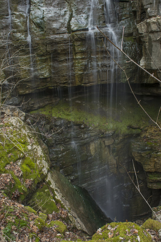
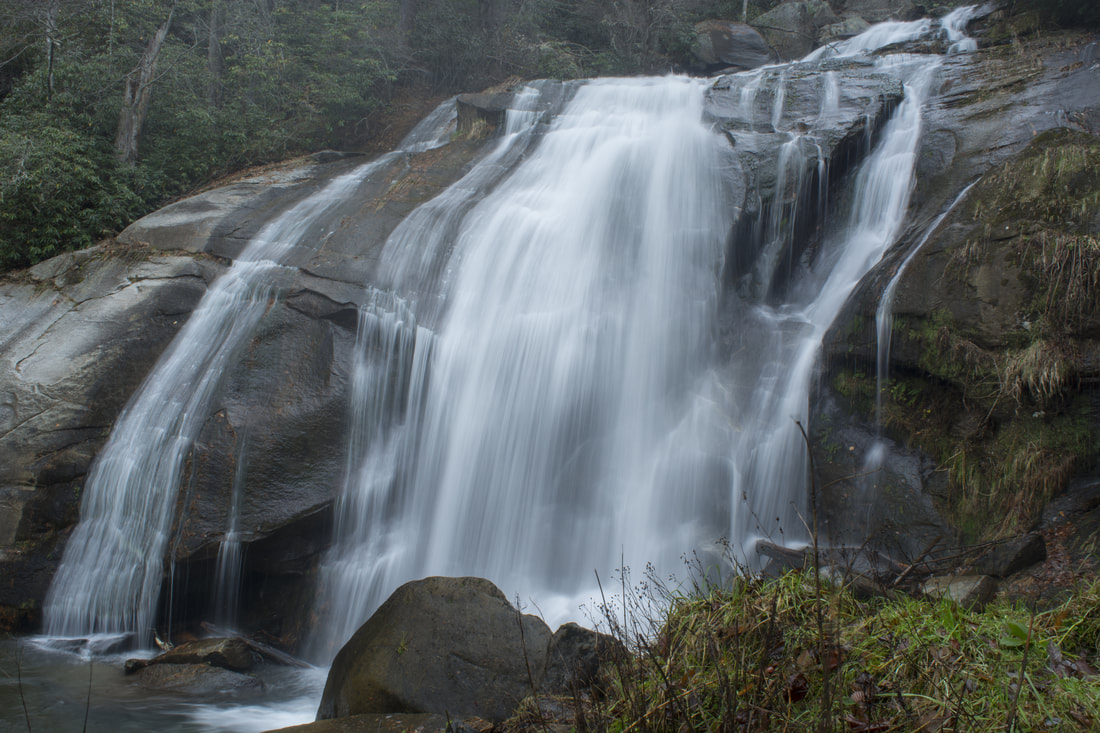
Chamberlain Trail is one of only two trails that ascends the east side of Pigeon Mountain from base to top. This lesser-known trail climbs at an easy to moderate pace through Atwood Gulf before meeting up with the Atwood Trail atop the mountain. While there aren't any notable attractions along the trail itself, a fantastic natural sight lies off-trail in Atwood Gulf: Nash Pit Falls. Have you ever heard the words pit and waterfall in one sentence? At Nash Pit Falls, a small stream flows out of a cave and instantly drops over 70 feet into the Nash Pit, a small but deep hole in the ground. In addition to the stunning Nash Pit Falls, this hike also visits a pair of McLemore Cove vistas on High Point - the highest point on Pigeon Mountain. This hike occurred on Saturday, January 13th, 2018. My plan was to hike the Chamberlain Trail from Chamberlain Road to Atwood Trail, making the bushwhack to Nash Pit Falls along the way. Next, I would follow the Atwood Trail to the Pocket/Bluff Trail. I would then follow the Pocket Trail and Bluff Trail in conjunction to the views on High Point. I would retrace my steps the same way.
2 Comments
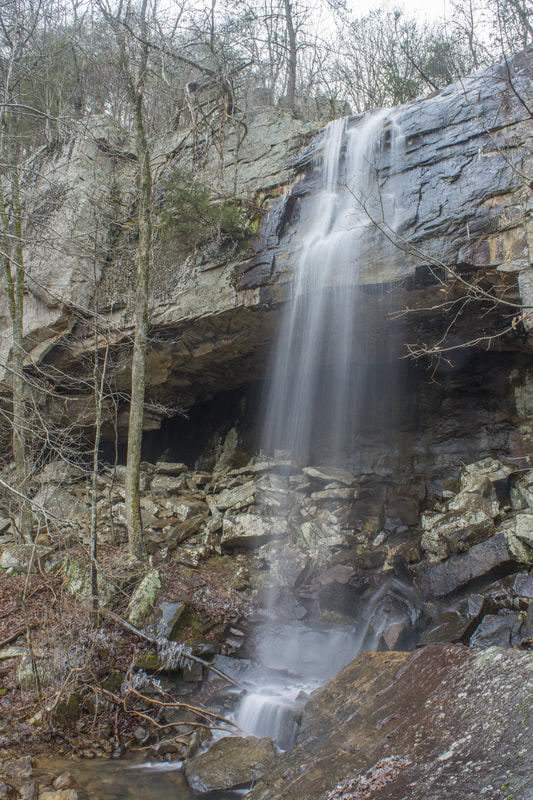
The Lost Wall is a bluff line that follows the east side of Pigeon Mountain for several miles. It's popular with rock climbers, and a trail follows the cliffs, passing many climbing access points. Only 0.15 miles from the trail's beginning at Rocky Lane, Dickson Creek comes over the Lost Wall and forms a 70-foot waterfall. During wet periods, free-falling Dickson Falls is one of the best waterfalls in the northwest corner of Georgia. The best part about it is how easily one can get to it! This hidden jewel is great for the whole family. This hike occurred on Saturday, January 13th, 2018. My plan was to hike the unofficial Lost Wall Trail out and back to Dickson Falls.
Apalachicola National Forest: Leon Sinks Geological Area Trail System, Tallahassee, Florida1/9/2018 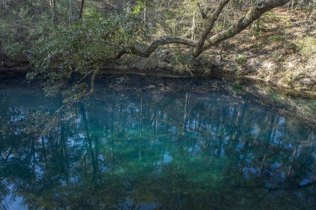
The Leon Sinks Geological Area is in the northeast corner of Apalachicola National Forest near Tallahassee. This fascinating area is home to over a dozen sinkholes, many of which have water in them. Particularly Hammock Sink is one of the most beautiful and photogenic natural sights in the region. The trail system at Leon Sinks also visits a disappearing stream with a natural bridge as well as a series of cypress swamps. Numerous points of interest are spaced throughout the 4.5-mile loop to keep your attention focused the entire hike. This hike occurred on Saturday, January 6th, 2018. My plan was to hike a counter-clockwise loop with the Sinkhole Trail and Gum Swamp Trail.
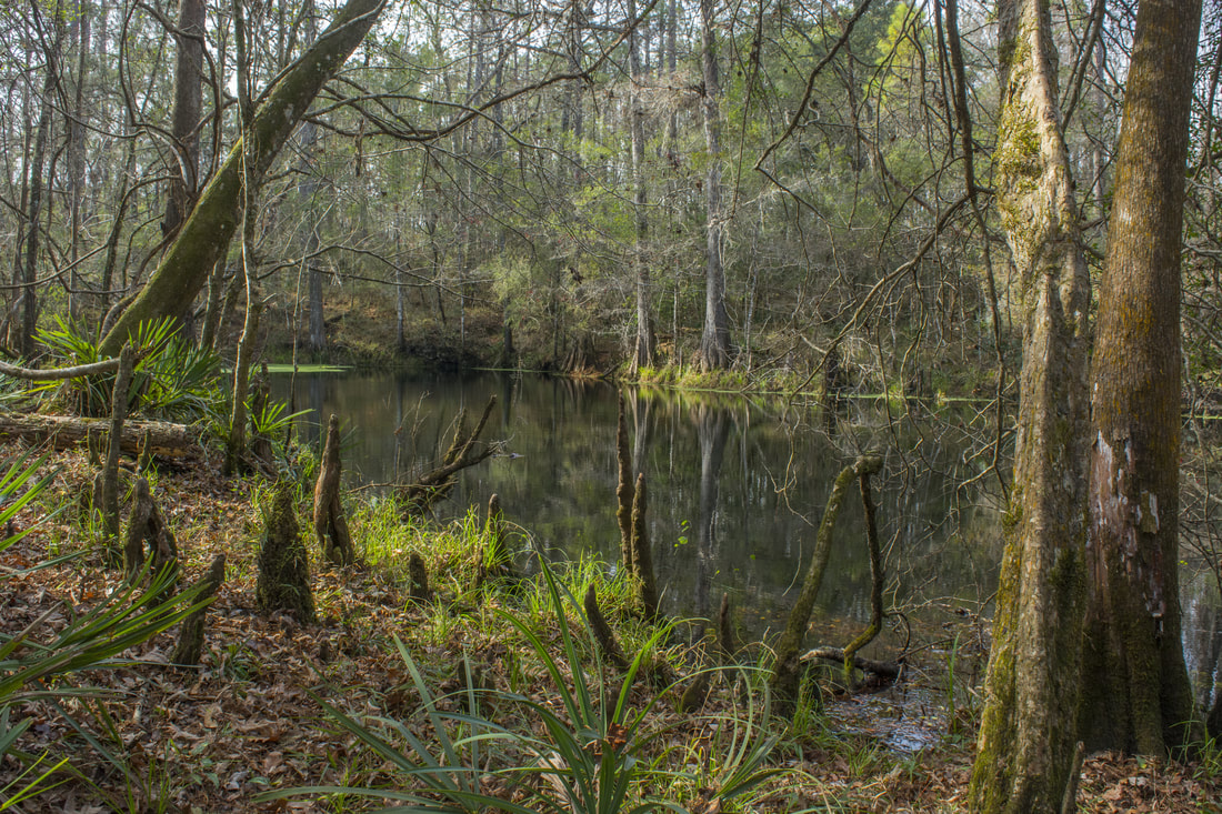
Most hikers of the Tallahassee area have heard of or even been to Leon Sinks. How many have heard of Wakulla River Sinks though? Along with adjacent Apalachicola National Forest, the River Sinks Tract - a lesser-known parcel of Wakulla Springs State Park - holds nearly two dozen water-filled sinkholes. The sinks serve as a portal to the mysterious underground water-filled cave system that eventually connects to the Wakulla River to the southeast. An official trail called the Wakulla River Sinks Trail passes by several small sinks, including the photogenic Clearcut Sink. If one extends their hike along the unofficial pathway that splits off and leads to a series of bigger sinks, including Promise Sink and Upper River Sink, they are bound to be astounded! This hike occurred on Saturday, January 6th, 2018. My plan was to hike the official Wakulla River Sinks Trail clockwise. Along the way, I would make out-and-back side trips to Clearcut Sink and along an unofficial trail to a series of sinks to the south.
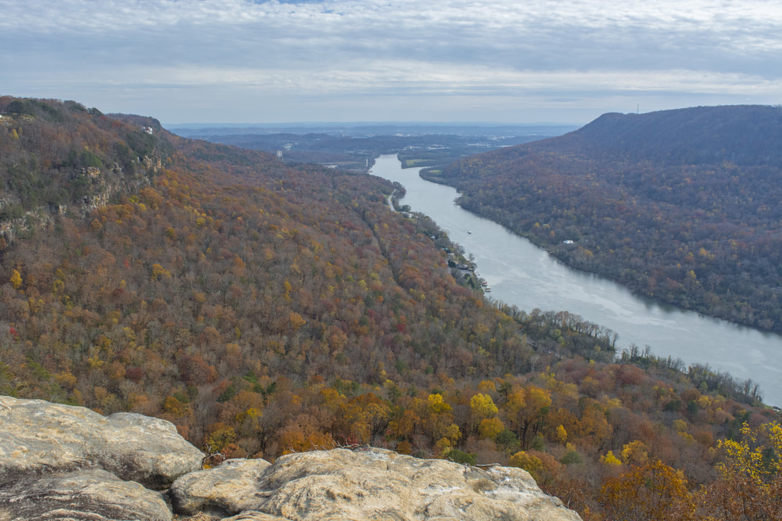
The Cumberland Trail, a work in progress that will be a 300-mile trail when completed, has its southern terminus at Signal Point in the Chattanooga metro area. One of the Cumberland Trail's most spectacular sections is its very first one as it traces the rim of the Tennessee River Gorge, visiting outstanding views at Signal Point and Edwards Point as well as a unique geological formation known as Mushroom Rock at the edge of the Suck Creek Gorge. Beside the Cumberland Trail, several lesser-used trails give hikers the option to turn a hike to Edwards Point into a full-day loop with additional sights. Most notable is a spectacular half-mile section of the Orange Trail as it follows a remote and rugged bluff line in the Middle Creek Gorge. This hike occurred on Saturday, November 25th, 2017. My plan was to hike a loop from Signal Point that would follow the Cumberland Trail past Edwards Point all the way to Mushroom Rock, from where I would follow the Mushroom Rock Trail, Blue Trail, Orange Trail, and Bee Branch Trail back to Signal Mountain. After coming out at Ohio Avenue, I would conclude the hike with a short roadwalk through the town of Signal Mountain to Signal Point.
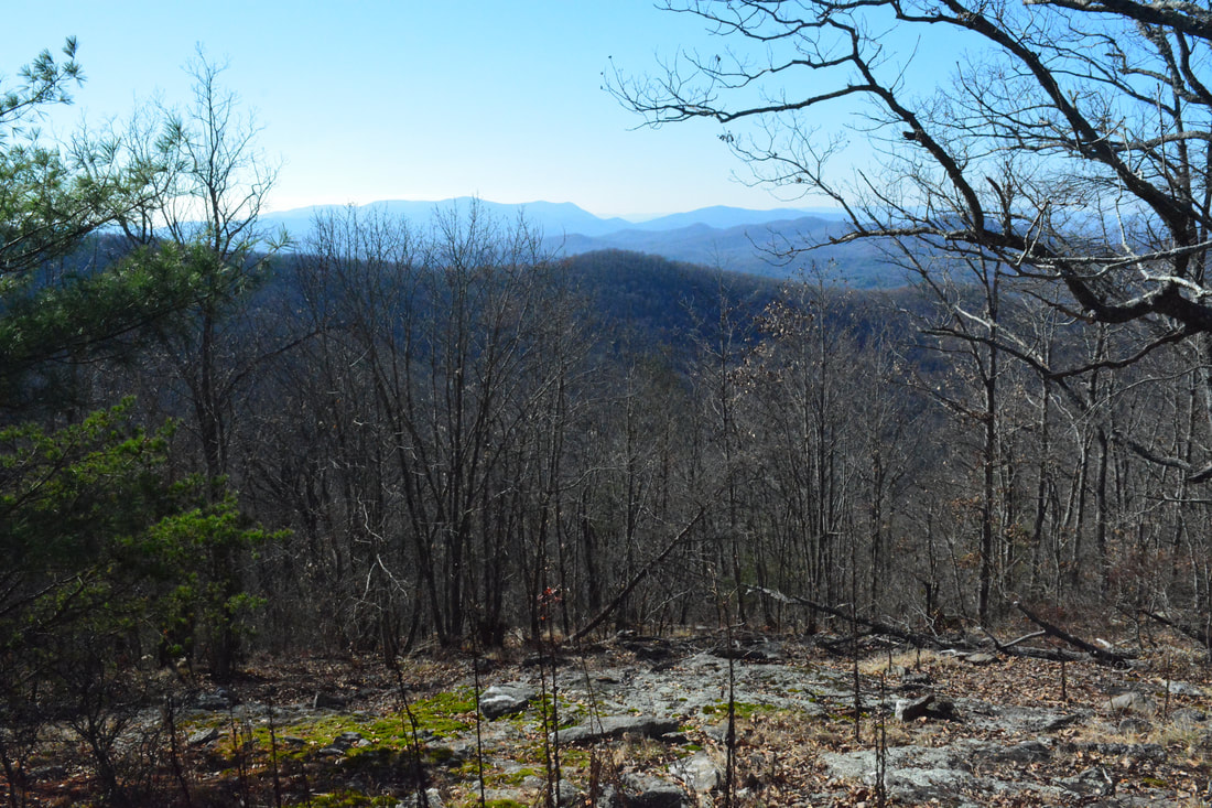
There's something about the Duncan Ridge Trail that sets it apart from most other trails in Georgia: its sheer difficulty. This unique trail constantly follows Duncan Ridge with its sharp knobs and deep gaps that present constant obstacles along the trail. The rollercoaster fashion of the Duncan Ridge Trail will give you a tough workout, and that's exactly why most people hike it - for there are no spectacular waterfalls anywhere on the trail. The trail is best hiked in the winter when bare trees allow continuous views in both directions from the ridge. Even though there is only one year-round view - on Rhodes Mountain - of any significance along the west part of the trail, seasoned hikers will still find it an enjoyable peaceful hike. This hike occurred on Thursday, November 23rd, 2017. My plan was to hike out and back along the Duncan Ridge Trail from Mulky Gap to the Benton Mackaye Trail Junction just past the view from Rhodes Mountain.
Chattahoochee National Forest: Haven Falls (His'n Her Falls) on Panther Creek, Clarkesville, Georgia12/13/2017 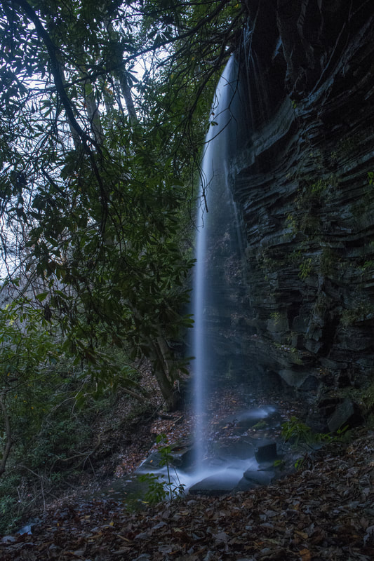
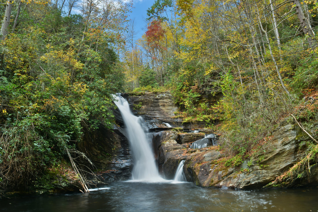
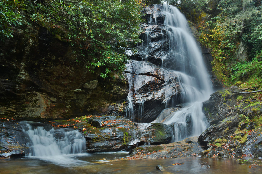
Most Georgia hikers are well-acquainted with Panther Creek due to an incredibly popular waterfall called Panther Creek Falls on this waterway, located several miles down the Panther Creek Trail off Old US 441. But did you know that Panther Creek is home to another significant waterfall that most folks have no clue about? The 50-foot Haven Falls is positioned much higher up Panther Creek, close to its headwaters where the flow is the best during winter or in wet periods. Nevertheless, this little-visited waterfall is a true beauty as it free falls over a long overhanging cliff and then cascades down a ledge and out of sight. Remarkably, the hike to Haven Falls is less than a mile long and is very easy along a well-defined route (an old forest road with a side path at the end) from Bear Gap Road. This hike occurred on Saturday, November 18th, 2017. My plan was to hike out and back to Haven Falls from Bear Gap Road.
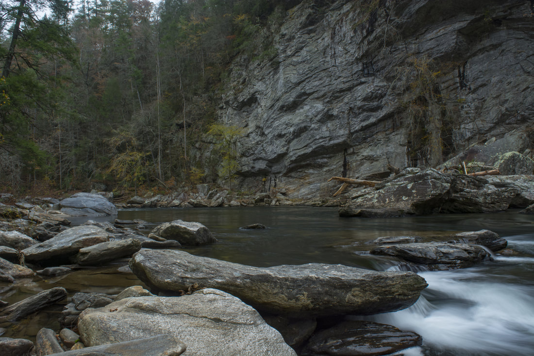
Raven Rock Cliff is a spectacular rock formation that towers over 100 feet above the Wild & Scenic Chattooga River. The well-maintained Raven Rock Trail makes a moderate descent into the Chattooga River Gorge from the end of FS 511B, terminating right across from Raven Rock Cliff - one of the most beautiful spots along Section Four of the Chattooga River. An easy rock scramble upstream will bring you to Raven Chute, a Class IV rapid stretching across the river. In the warm season when the water is high enough, it is fun to watch kayakers negotiate the rapid. This hike occurred on Saturday, November 18th, 2017. My plan was to hike out and back along Raven Rock Trail to the Raven Rock Cliff.
Highway 106 crosses Middle Creek just over a mile north of the Georgia State Line on its way to Highlands, but few people would guess that one of the area's most amazing waterfalls lies a half-mile downstream. First, Middle Creek goes over the 40-foot Upper Middle Creek Falls for a warm-up before plunging into a steep gorge as it drops off the escarpment. That's where Middle Creek Falls lies - a jaw-dropping high-volume waterfall that crashes 75 feet down a steeply slanted rock face with more falling water above and below. During wet periods, you're going to get drenched by the waterfall's spray without even getting close! Whereas the upper falls is very easy to reach, a confusing and faint path must be successfully navigated to reach Middle Creek Falls. This hike occurred on Saturday, November 18th, 2017. My plan was to hike out and back to Upper Middle Creek Falls and Middle Creek Falls.
Pinhoti Trail: Keown Falls Trail, Johns Mountain Trail, and Pilchers Pond, Calhoun, Georgia11/17/2017 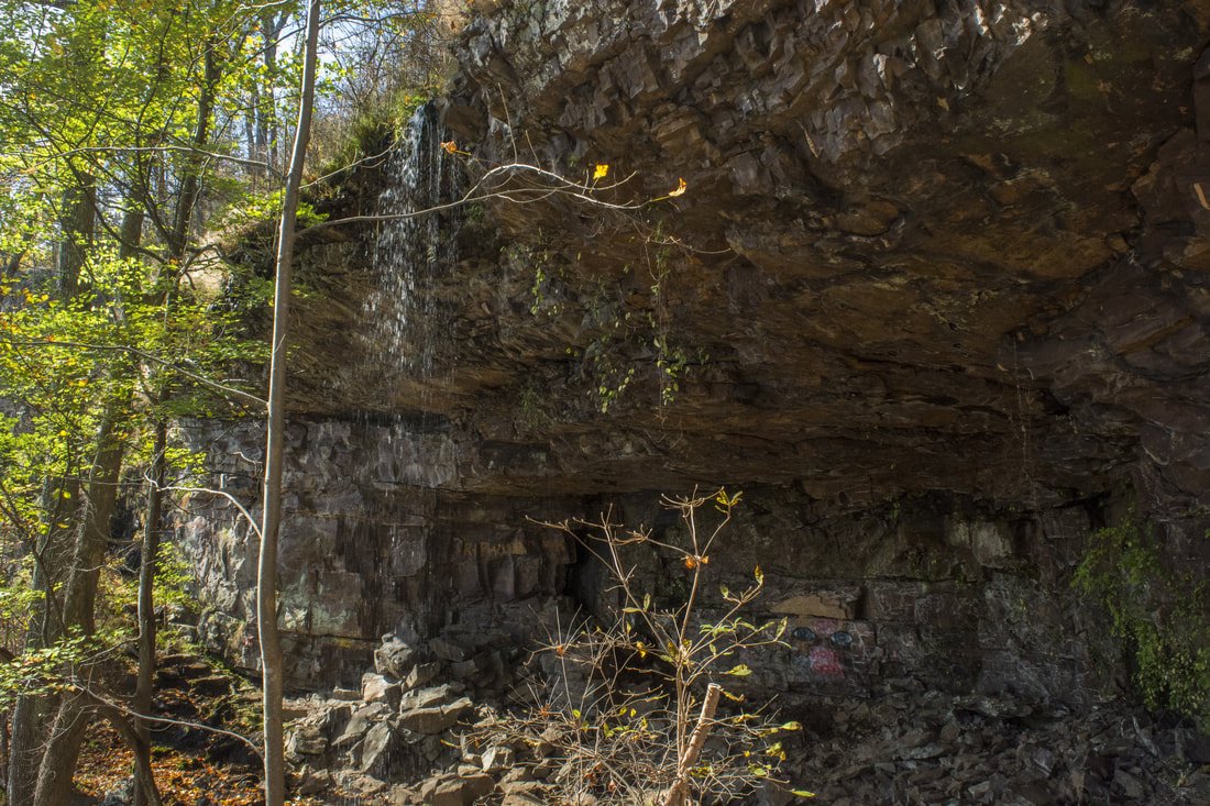
The Valley and Ridge area of Northwest Georgia is not known for waterfalls, unlike almost every other mountainous section of the state. Most of the available hikes in this area simply follow low ridges like Horn Mountain, Johns Mountain, and Taylor Ridge that separate similar valleys. The Keown Falls Scenic Area is unique to the region, as it is home to the area's two only publicly-accessible waterfalls: South Keown Falls and Keown Falls. Both waterfalls are accessed easily by the Keown Falls Trail, but it's worth extending the hike along the Johns Mountain Trail, which has great winter views from Johns Mountain. There are some other opportunities to extend the hike, such as following the Pinhoti Trail along Johns Mountain Road and past Pilchers Pond - although hikers may not find that part of the trail particularly exciting. This hike occurred on Saturday, November 11th, 2017. My plan was to hike a loop with the Keown Falls Trail, Johns Mountain Trail, FS 208, and the Pinhoti Trail past Pilchers Pond, starting at the end of FS 702. Unfortunately, the quality of this longer loop hike was degraded by a rather ugly logged area on the north side of Johns Mountain Road.
Preachers Rock is a well-known destination along the Appalachian Trail on Big Cedar Mountain that features a great view of the Blood Mountain Wilderness. A couple of other trails in the area can be utilized to create a loop hike from either Chestatee Overlook (on Highway 60) or Dockery Lake, visiting one other vista as well as up to three waterfalls. The unofficial Steeltrap Knob Trail provides a useful connection between Chestatee Overlook and Woody Gap, at the same visiting a spectacular view of the Georgia Piedmont from little-known cliffs on the side of Steeltrap Knob. Meanwhile, the Dockery Lake Trail travels through the Pigeon Roost Creek Valley between Dockery Lake and the Appalachian Trail. While no waterfalls are right on the trail, visiting Martha's Falls, Twin Falls, and Dockery Lake Falls will require only short off-trail diversions. This hike occurred on Sunday, October 29th, 2017. My plan was to hike a loop from Chestatee Overlook, starting with the Steeltrap Knob Trail and stopping by the Steeltrap Knob Vista along the way. I would then take the Appalachian Trail over Big Cedar Mountain and to the Dockery Lake Trail, stopping by several views from Big Cedar Mountain along the way, including Preachers Rock. Next, I would take the Dockery Lake Trail to Dockery Lake, visiting Twin Falls, Martha's Falls, and Dockery Lake Falls along the way. I would conclude the hike with a walk up Dockery Lake Road back to Highway 60 and Chestatee Overlook.
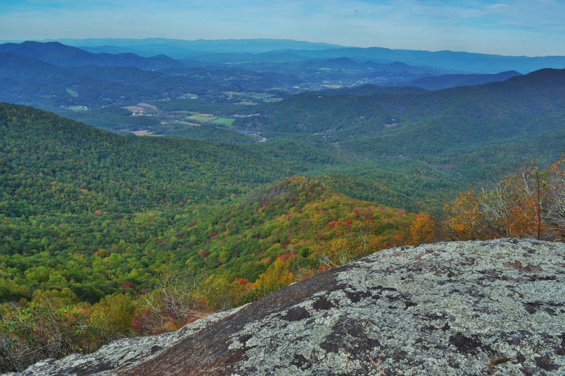
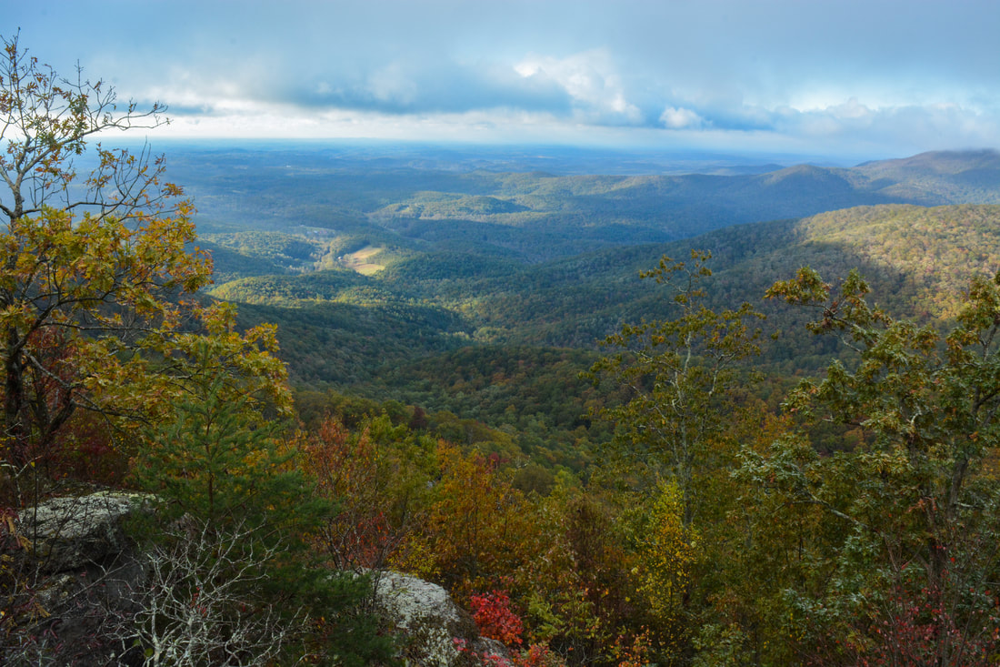
The Arkaquah Trail has always been one of Georgia's most famous trails thanks to its difficulty and its approach to the tallest peak in the state. Of the three different trails that summit Brasstown Bald, the Arkaquah Trail is undoubtedly the most scenic. In fact, whereas the crowded summit of Brasstown Bald with its large observation tower may not be alluring to wilderness hikers, three other vistas can be found near the Arkaquah Trail. The view from Chimneytop Mountain in particular is arguably one of the state's most jaw-dropping views with its 180-degree panorama! Even more remarkable is that this view remains largely unknown to the hiking community despite its proximity to the Arkaquah Trail. With the two other beautiful overlooks plus the Brasstown Bald summit accessible via the trail, the Arkaquah Trail is one of the most scenic hikes in North Georgia. This hike occurred on Saturday, October 21st, 2017. My plan was to hike out and back along the Arkaquah Trail to the summit of Brasstown Bald, making side trips to the three views along the way.
Southwest North Carolina's Wolf Creek sure is a potent stream with the six major waterfalls it is home to. The tallest and best-known waterfall on the creek is Wolf Creek Falls aka Paradise Falls below Wolf Creek Lake. But higher up on Wolf Creek is a set of four breathtaking pristine waterfalls clustered close together near Balsam Lake. The series of falls culminates with Lauren Falls, a spectacular near free-fall with a deep pool surrounded by beautiful water-sculpted rock outcrops. The hike to these waterfalls, especially Patricia Falls and Lauren Falls, is quite difficult as it involves a lot of off-trail scrambling, but less experienced hikers have the choice to hike just to the first waterfall, Balsam Falls, which is considerably easier to reach with only minimal scrambling. Along the way, visitors will be treated to many gorgeous views of Balsam Lake along the Mallonee Trail. This hike occurred on Saturday, October 14th, 2017. My plan was to hike to the Mallonee Trail along Balsam Lake from Balsam Lake Recreation Area to Balsam Lake Dam, from where I would follow faint paths to Balsam Falls, Lower Balsam Falls, Patricia Falls, and Lauren Falls. I would return the same way.
The Little Canada area of Southwest North Carolina is home to a vast array of majestic waterfalls, and Sols Creek is one of the area's signature creeks. Few North Carolina waterfalls are as jaw-dropping as Sols Creek Falls near the creek's lower end, but unfortunately, that falls is on private property. In contrast, Upper Sols Creek Falls is on National Forest land and is nearly as impressive as its taller brother. Tumbling 65 feet down a huge cliff, Upper Sols Creek Falls is a spectacular waterfall and falls into a fairly easy-to-reach category. The unofficial trail to the falls has a few creek crossings but is mostly in good shape and can be walked by hikers of nearly all levels. In fact, the most difficult part of the hike may be finding the obscure trailhead and pullout parking. This hike occurred on Saturday, October 14th, 2017. My plan was to hike out and back to Upper Sols Creek Falls from NC Route 281.
While the views atop Big Cedar Mountain along the Appalachian Trail are well-known, its lower brother Little Cedar Mountain on the other side of the quaint community of Suches is far more obscure. Despite this, a good trail leads to Little Cedar Mountain, where a set of cliffs provides a great view into the Canada Creek valley. The picturesque view is only the beginning though - a connecting trail leads deep into the Canada Creek valley, where a set of four breathtaking waterfalls await. Ranging from only 15 to over 50 feet high, all four waterfalls are fairly easy to reach thanks to an intricate network of unofficial trails along forest roads and fainter paths up and down the Canada Creek watershed. This hike occurred on Saturday, October 7th, 2017. My plan was to hike from Highway 60 to the vista atop Little Cedar Mountain. From there, I would scout out one route down into the Canada Creek valley and another on my way back (as I learned, only one route had a trail). Once in the valley, I would follow trails to Canada Creek Falls, Ontario Falls, and Alberta Falls, and if time permitted, Yukon Falls too.
|
About MeMark Oleg Ozboyd Dear readers: I have invested a tremendous amount of time and effort in this website and the Georgia Waterfalls Database the past five years. All of the work that has gone in keeping these websites updated with my latest trip reports has almost been like a full-time job. This has not allowed me to pick up a paid job to save up money for college, and therefore, I I've had to take out loans. If you find the information on this website interesting, helpful, or time-saving, you can say "thanks" and help me out by clicking the button above and making a contribution. I will be very grateful for any amount of support you give, as all of it will apply toward my college tuition. Thank you!

Coming in 2022-2023?
Other Hiking WebsitesMiles HikedYear 1: 540.0 Miles
Year 2: 552.3 Miles Year 3: 518.4 Miles Year 4: 482.4 Miles Year 5: 259.9 Miles Archives
March 2021
Categories
All
|
 RSS Feed