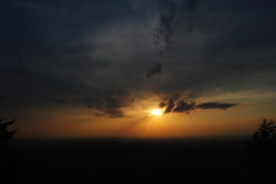
 There's wilderness even in Alabama. In an area of low-elevation ridges and long valleys lies the Cheaha Widerness of the Talladega National Forest. While this is only a mini version of the mountains further north, the Talladega National Forest has numerous hiking trails, with many leading to grand views. While this wilderness is not as "wild" and rugged as the ones in Georgia and North Carolina, it still isn't an easy hike. This hike occurred on Saturday, May 17th, 2014. My plan was to drive up the Talladega Skyway to the Cheaha Wilderness Trailhead. I would hike the Cave Creek Trail to the Pinhoti Connector, follow the Pinhoti Connector to the Pinhoti Trail, and follow the Pinhoti Trail back to the parking lot. Along the way, I would stop at McDill Overlook for what was clearly the most beautiful view I have seen in Alabama, if not one of the most beautiful views I have seen in Alabama and Georgia combined. R/T Length of Trail: 7.5 Miles Duration of Hike: 4 Hours, 15 Minutes Type of Hike: Balloon-on-String Loop Difficulty Rating: 5 out of 10; Easy to moderate, but one relatively steep and prolonged climb; numerous downed trees on Cave Creek Trail, perfect trail condition on Pinhoti Trail Beginning Point: Cheaha Wilderness Trailhead on Alabama State Route 281 Directions: From Anniston, AL: Take I-20 East to Exit 191. Take Exit 191 towards US 431, and turn right onto US 431. Follow US 4313.6 miles to County Road 131, and turn right onto it. Follow County Road 131 for 0.6 miles until AL State Route 281 (Talladega Skyway). Turn left and follow it for 12 miles until the parking lot and the trailhead on the left. An original plan to hike at Siler Bald in Southwest North Carolina had to be rapidly changed, when I saw a large area of heavy rain on radar in the morning before my hike. I don't like hiking in the Piedmont, and south of I-20 for that matter.There's almost no mountains, and the trails are boring. However, I didn't know that a small section of the Talladega National Forest in Central Alabama, registered as the Cheaha Wilderness, was otherwise. The views from the area were incredibly rewarding, and almost at the level of many of my hikes in Georgia and North Carolina. I think I'll be back to this area soon. Anyway, let me get to the description. When I arrived at the parking lot of AL State Route 281, there were a few cars, but the lot itself was on the small to moderate side. There is a large sign warning about not keeping valuables unattended. At the far end of the parking lot, there's a large archway, with a decorated rock path as the start to the trail. The entrance was pretty grand, but it did not really lessen the amount of fallen trees on this trail, did it? At the place where the dirt trail started, there was a trailhead kiosk. There was a nice trail map and some basic information about the area. There were some notices about bears, although I doubt that they can be found here. Moving my eyes from the kiosk to the trail, started my hike. Almost right away, there was a trail junction, and the start of the loop. Since this trail isn't too hard, it doesn't matter which way to hike it, but I decided to hike it clockwise. So for the description of this hike, bear left at the intersection, following the sign "Cave Creek Trail ^". To the right went the Pinhoti Connector Trail, which was the way of return. The Cave Creek Trail started off by crossing a muddy trickle, and passed through a power line clearing at 0.2 miles. This clearing gave a decent view of the surrounding area. The next mile or so of the Pinhoti Trail was pretty easy. The trail was flat, with the occasional downhill, and several downed trees. The trail crossed a small stream at 0.5 miles, and went through a rocky area at 0.8 miles. The trail crossed another stream at 1 mile, the forest thickened, and there were more rocks around too. At 1.4 miles, the trail entered the Cheaha Wilderness. I was greeted with a bunch of downed trees. In the process of getting over one of the trees, I slipped and fell off the trail into the brush. No damage done! At about 1.6 miles, the first overlook of the day appeared to the left. The trail sharply switchbacked to the right, while the rock outcrop was to the left. The views were pretty good, and the town of Lineville could be seen from here. After this, the trail accomplished a gradual ascent. As it passed through a gap, there was a campsite to the left, while the trail beared right. I was now headed for Cave Creek. The trail reached and crossed Cave Creek at 2.1 miles. No wet feet, as there were numerous rocks. I found it interesting to zoom into a small cascade on the stream, although there were no significant waterfalls here. After this, the trail gradually ascended again, eventually getting above 2000 feet and reaching a considerably rockier area. At 3 miles, there was a trail junction. Forward, the Cave Creek Trail continued towards the Nubbin Creek Trail and Odum Scout Trail, while to the right, the Pinhoti Connector Trail went towards Pinhoti Trail. For the goal of this hike, I turned sharply right. The trail reached the top of Talladega Mountain in 0.1 miles, and became less defined in the midst of a boulder field. On the other side of the ridge, the trail became well-defined again, and reached the Pinhoti Trail 0.2 miles from the previous junction, and 3.2 miles into the hike. Turn right here on the Pinhoti. If going left, you will reach the Chinnabee Silent Trail in about 2 miles, and eventually Adams Gap on AL State Route 281. By turning right, you will reach Cheaha State Park in 4 miles. Once I turned right, there was lots of blazes. Both old, dark blue, and new, light blue blazes were abundant. The trail was super slow as it traversed a large boulder field. Don't hurry; watch your step. Sporadic views did come up towards the west. About a mile from the Connector, and 4.2 miles into the hike,the trail reached the Cheaha Wilderness boundary, and re-entered the State Park property. With the boundary, the rocks almost disappeared. The trail soon turned west, crossed a dry stream bed, and beared southwest. The change of direction was temporary though. A gradual ascent followed, along with a downed tree, before the trail finished climbing, and reached a trail junction at 4.7 miles. Here, the Pinhoti continued forward, but a 0.2 mile spur turned left towards McDill Overlook. The spur trail started off with a gradual descent. There were remnants of a plane crash on the right, next to a campsite. Then, the trail ascended a bit, passed by a set of campsites, and opened up onto a large rock outcrop. Views were incredible, and truly the best I've seen in Alabama and this hike. I could see Talladega Mountain where I was earlier, as well as the continuation of the Talladega National Forest extending further south. The mountains were all green, very green. This was certainly a place to linger. Eventually, I left the overlook, and climbed back up to the Pinhoti. After the junction, the Pinhoti suddently descended steeply, only to climb back as steeply and amidst rocks to McDill Point. Here, there was another rock outcrop with a nice view of the valleys, although not as grand as McDill Overlook. At 5.6 miles there was another overlook with views of Cheaha Mountain, and then, the trail briefly descended. However, the climb to Hernandez Peak started at 5.9 miles. It was the longest and steepest climb on the hike, although never too steep. As the trail topped the peak, it traversed a long and flat ridgeline. It was covered in grass and ferns. On one of the small rocks along the trail, there was a small memorial regarding the Cheaha Wilderness. At 6.4 miles, the trail sharply turned left and jumped down a steep and rocky descent, followed by a more gradual descent into a muddy drainage. At 6.6 miles, the trail briefly joined an old, deteriorating road, although leaving the road by bearing left shortly. After another short ascent, there was a large memorial describing the linkage of the Pinhoti with the Benton Mackaye and Appalachian Trails, which was finished in 2008. Next to the memorial, there were two spiderworts, which I successfully photographed. Also, there was a campsite, and a nice vista, with views of the alley below (similar to the overlook at McDill Point). This was where I saw one of the best mountain sunsets in recent months. Nice ending to the hike. The trail started another descent, and crossed the old road at 6.9 miles. Soon, the trail went through a powerline clearing (that I crossed in the very beginning), and reached a trail junction at 7.2 miles. The Pinhoti continued forward toward Cheaha State Park, but I turned right onto the Pinhoti Connector. The Pinhoti Connector was somewhat faint, as it steeply descended back down to the Cave Creek Trail at 7.4 miles. I turned left, and finished the loop at 7.5 miles. In summary, this is a very enjoyable hike, and a gem for Alabama hikers. The views are superb, and there's no hard sections/ I rarely do two "Best Hikes" in a row, but nevertheless, I am calling this a "Best Hike". See my pictures and videos below.
8 Comments
Jeff Pedron
6/11/2014 02:07:42 am
My wife and I did this hike in January as we were traveling home to Memphis from Atlanta. Agreed, excellent hike with great amenities in close proximity to Cheaha State Park. We did it as an "afterthought" with limited time but would have enjoyed an overnighter just to enjoy the outdoors...instead opted for one of the outstanding rustic cabins overlooking the valley on Mt. Cheaha.
Chris Brown
1/26/2015 01:29:41 am
Our troop (Troop 354, Shelby District, GAC) just completed this trail this weekend. A lot of blowdown from the tornadoes a few years ago, but still a beautiful trail with many, many good views. McDill Point is a great place to camp and the sunsets there are amazing.
Peter O'Hare
10/6/2015 11:29:47 pm
Chris,
Holli McCullough
3/13/2016 11:07:04 am
My husband and I have done this hike twice... I agree McDill Point is wonderful!
Linda Vanderberg
2/24/2018 04:04:06 pm
Hey! Just thanking you for this awesome report. Four of us started out unprepared for a 2 mile in and 2 mile out. There wasn’t enough information that we could find and we lost our way?? We had enough cell phone service to check out a map online but not much help!! Somehow your blog popped up (God Intervention) and it was what trail we found ourselves on.. so we followed everything you did and finally got back to parking lot in 6 hours, hot, hungry and thirsty but praising you❤️!!
Brent Snider
2/16/2019 06:22:18 pm
Wife and I hiked this today. It was our first over 3 mile hike. Mark your description of hike was spot on. To us this hike was about 2.5 miles too long for us!!!!!! Lol! We are going to do some getting Into shape before we return so it will be more enjoyable. We do give the trail and your description a 5 star tho. Although it was dense fog the entire day.
Miles Bajko
3/5/2019 07:38:20 pm
My buddy and I decided to hike the trail out to McDill Overlook on a sunday in Feb 2018 and were going to hike the cave creek trail on the way back. The first section out to the Overlook was awesome but then this dense fog and rain moved in on us. We continued on, the trails were marked we didn't think much of it. Somewhere about halfway down on the cave creek trail, we ended up taking a wrong turn but didn't know it. We got down to a creek and replenished our water with a filter and carried on. With about 2 hours til dark, we thought for sure we were not on the right trail. Without much cell service, we were finally able to see ourselves on the map and we were way off track. We had three options, go to the nearest road and hike on the road back to the parking lot, go back the way we came (which wasn't well marked) or B line it for the parking lot which was about 5 miles as the crow flies away. We decided to B line it..... we got our heading and trekked on. About 9pm we finally hit the guard rail Leave a Reply. |
About MeMark Oleg Ozboyd Dear readers: I have invested a tremendous amount of time and effort in this website and the Georgia Waterfalls Database the past five years. All of the work that has gone in keeping these websites updated with my latest trip reports has almost been like a full-time job. This has not allowed me to pick up a paid job to save up money for college, and therefore, I I've had to take out loans. If you find the information on this website interesting, helpful, or time-saving, you can say "thanks" and help me out by clicking the button above and making a contribution. I will be very grateful for any amount of support you give, as all of it will apply toward my college tuition. Thank you!

Coming in 2022-2023?
Other Hiking WebsitesMiles HikedYear 1: 540.0 Miles
Year 2: 552.3 Miles Year 3: 518.4 Miles Year 4: 482.4 Miles Year 5: 259.9 Miles Archives
March 2021
Categories
All
|
 RSS Feed