HIKING THE APPALACHIANS AND BEYOND
  • Home
  • Trail Reports
    • Best Hikes
    • Hikes with Scenic Views
    • Hikes with Water Features
    • Alabama
    • Georgia
    • Florida
    • North Carolina
    • South Carolina
    • Tennessee
    • Vermont
    • Virginia
  • Map
  • Hike List
  • Testimonials
  • Resources
  • Contact Us
  • Southeast Nature Society
    • Our Team
  • Georgia Waterfalls Database

Cheaha Wilderness: Chinnabee Silent Trail, Oxford, Alabama

8/1/2014

1 Comment

 
Picture
Cheaha Wilderness is the first of two wilderness areas in Alabama's Talladega National Forest. The wilderness is named after Alabama's highest peak, Cheaha Mountain. The wilderness is located in the southern half of Talladega National Forest, and is shaped as a thin rectangle east of Highway 281. A large trail systems lies across the wilderness and surrounding areas, making it easy to travel through different portions of the wilderness. One of the trails in particular, Chinnabee Silent Trail, starts at Lake Chinnabee in the western end of Talladega National Forest, and meanders a half dozen miles through the area, with the last 2 in the Cheaha Wilderness, before terminating at the Pinhoti Trail. This hike occurred on Saturday, July 26th, 2014. My plan was to hike the entire Chinnabee Silent Trail from west to east, and return the same way. 

The terrain across the Talladega National Forest in Alabama consists of hills and low elevation ridges. It's good to take a break from the higher mountains and hard trails, but... I didn't expect a trail where I had to put a 7/10 difficulty. I haven't done that much hiking in Alabama, but I would say that this trail is much harder than for Alabama standards. The first 4 miles are enjoyable though, but if you are doing this hike solely for pleasure and not for challenge, then you probably wouldn't want to proceed onto the last 2 miles. I'll explain why later. 


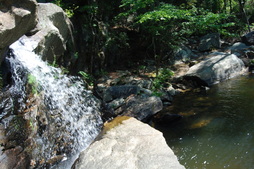
When you arrive at the Lake Chinnabee Recreation Area, make sure to pay your $3 fee. The sign "DID YOU FORGET TO PAY" at the start of the trail was somewhat amusing. The recreation area is named after Lake Chinnabee, a small lake (about 10 acres) on Chinnabee Creek. The parking area is pretty big and was almost full when I arrived. However, most of the people just go swimming; I saw only two groups of hikers the entire hike. The trail starts at the restrooms at the end of the parking area and passes through the abandoned campground. At the end of the campground, the asphalt turns into a rooty path along Chinnabee Creek, and you'll see a trailside kiosk and a sign with mileage information.  The trail starts off flat, but shortly comes to a junction with the Skyway Loop Trail at 0.2 miles.I am not sure why it has the part "Loop" in it,but it is an out and back trail that leads to Adams Gap on the Pinhoti Trail. The only reason I see for the name is that it may be named so because there is a 15 mile loop option combining the Chinnabee/Skyway/Pinhoti Trails. I decided to save the loop or the Skyway Trail for another day. To continue following the Chnnabee, take the left fork. Unlike the Skyway Trail which stays at creek level, the Chinnabee ascends somewhat steeply above the creek. The ascent is not long though; the trail comes to a clearing in the trees and ascends to near the canyon rim. From here, there are great views of a bend in Chinnabee Creek known as "Devil's Den". Devil's Den is a short but rugged canyon that the trail was about to enter. After snapping a few photos, I was off. The trail is somewhat rocky as it rounds the bend, and then crosses a footbridge that clings to the rocky cliffs. At 0.5 miles, the trail reaches the heart of Devil's Den. It descends through a jumble of rocks, and then further down a rickety rock staircase. After this, there were a couple side trails that led down to the creek and its rapids. I didn't bother taking them because the overlook areas was stocked with local folks swimming. 


After this, the trail ascends again to another footbridge and passes some rock outcrops and overhangs, before finally descending out of Devil's Den and to creek level. This section of the trail is very rocky as it follows the creek, and is also abundant with campsites. There was a small creek crossing of a tributary, although a wooden plank aided. At 0.8 miles, the trail left Chnnabee Creek for good, and began a gradual ascent out of the valley and onto the surrounding hills. At 1 mile, the trees thinned and some views opened up on the right. You can see some low ridgelines in the near range, but on the horizon, you can see a taller ridgeline. While it seems like it will take over a day to get there, that ridgeline is actually the hike's final destination, believe it or not. Following the overlook, the gradual ascent continued, coming to a close at 1.5 miles. After this, the trail crossed a stream bed and climbed to the summit of a hill. The growth here was a lot of shrubs and low lying vegetation, which made the path narrow and somewhat overgrown. On the other side of the hill, a brief descent was followed by an ascent to another hill. On the descent from this hill, the trail crossed a very old and overgrown road at 2.5 miles. Somehow, Google Maps still lists this as a drivable road... After this, the trail crossed another stream bed, and gently ascended to another hill. It reached the summit at 3 miles, and I was greeted by the Cheaha Falls shelter. It is a sturdy structure for overnight hikes and/or Pinhoti Trail thru-hikers. There were some informational maps nailed to the side of the shelter as well. The best views from the hike were also from this shelter. It was not a well-defined overlook, but the threes were far apart here, and the main vegetation was shrubs and other low-lying vegetation. Thus, there were nice views of the Talladega Mountain ridge now closer, the destination of the hike. The sounds of Cheaha Falls were heard below. 


From the shelter, there are a couple paths. Take the one that descends directly from the shelter, and watch for faded white blazes. The descent here was somewhat steeper than from the previous hills, although still gentle. The Chinnabee Silent Trail descended more steeply with a few switchbacks as it approached Cheaha Creek, and it reached the creek at 3.2 miles. The trail crosses the creek by a long, narrow rock slab. No wet feet needed. However, there is no way to tell that there is a waterfall nearby. There's no sign ether. I never figured out how to get to the pool below the falls, but to get to the side of the falls, follow the creek downstream. Unless there is very high water, it's easy to stay dry; there's plenty of large boulders. it's about 100 feet downstream to where you see the large pool ahead. Once you reach the last rocks, the waterfall is on the left. It's not high, but it was pretty, especially with the angle. I estimated a 20-30 foot drop. The pool was certainly inviting for swimming, but no one was here besides a pair of hikers. All the swimmers were at the beginning of the hike. The main break of the hike was here. In about 20 minutes, I decided to continue with the hike. 


On the other side of Cheaha Creek, the trail ascends gradually to another hill, and then descends to cross a tributary of Cheaha Creek without problems. At 3.5 miles, the trail reaches an FS Road that is a connector between Lake Chinnabee Road and HWY 281. After this, the trail meanders between hills and across another small stream to reach HWY 281 at 3.9 miles. There's a great view of Cheaha Mountain looking up the road. After the road, the trail descends to yet another small creek and reaches the Turnipseed Campground Road at 4 miles. The shape of the road was dilapidated, but there were a few campers there. After this road, the trail descends past a trailside kiosk with information about the  Cheaha Wilderness. Shortly afterwards at 4.1 miles, the trail reached the Cheaha Wilderness boundary. After this, the trail changed drastically; if you've come here just for enjoyment, then it's best to turn around at HWY 281 or the Wilderness boundary as latest. On the other hand, if you are here primarily for challenge, then the last 2 miles might be for you. The trail crosses a larger creek right after the Wilderness boundary. In normal water levels, it is rock hoppable. After this, the next mile is slow but steady ascent, and around 4.5 miles, boulder fields started to make an appearance. At 5 miles, you will hear a creek to your left, but you will never cross it; instead the trail turns sharply right. 


Just like a winter may have a textbook change from a warm December to a normal January to a cold February, the ascent in the last mile kept getting steeper but very rationally. I bet you could approximate the amount of feet you climb every 0.1 mile by a linear equation. Anyway, starting from the 5-mile mark, the trail started ascending more steeply through constant boulder fields. At 5.5 miles, the trail crossed a drainage, and then the ascent got really steep. There were several places where the trail went straight up with few switchbacks. The steepest was right at the end, where the trail passed some rock walls and over numerous rocks. Finally, at 4.9 miles, the trail suddenly began to level out, and reached the Pinhoti Trail at 4 miles. There is a large sign and a campsite at the junction, but no good views. Just sporadic views through trees. If you continue forward, you'll be on the  Odum Scout Trail, which will bring you to the High Falls Trailhead in 4.5 miles. If you turn left onto the Pinhoti, you'll be travelling north towards Cheaha Mountain, while if you turn right, you will be travelling south towards Adams Gap. Turning right would also be the next step, if you were doing a loop with the Skyway Trail, but for this hike, this was the turnaround point. The ascent in the end was certainly manageable, but it was steep! It took me 10 minutes to get down a section it took me 30 minutes to get up. 


In summary, this s a very enjoyable (for the most part) top-class Alabama hike. there's everything from views... to rolling hills... to some views... and even a steep section thrown in for good measure. Just know that f you continue past mile 4, it's mainly for challenge, because there's no big attractions over there. And if you are swimming in the area... go on a hike too! Just the out and back to Cheaha Falls is rewarding in its own, and only 6 miles. Put your backpack on and get to work! 
R/T Length of Trail:  12 Miles
Duration of Hike: 6 Hours, 20 Minutes
Difficulty Rating: 7 out of 10
Pros: Water features; some views; swimming holes; more  than half of the trail is relatively easy and enjoyable; overnight shelter
Cons: $3 fee; heavy crowds in the beginning; rocky and eroded trail in the first part near Chinnabee Creek; very steep and rocky approaching Pinhoti Trail
Best Season(s) to Hike: Winter
Trail Blaze Color(s): Chinnabee Silent Trail - White (none in Cheaha Wilderness)
Beginning Point: Main parking area in Lake Chinnabee Recreation Area
Directions: From Oxford, AL: Follow AL State Route 21 south to McIntosh Road. turn left and follow McIntosh Road for 3.2 miles. Then, turn right onto Kentuck Road. Follow Kentuck Road for 7.5 miles (it will become unpaved shortly). At the T intersection, turn right onto Cheaha Road, and follow it for 1.1 miles. At the sign for Lake Chinnabee Recreation Area, turn left onto Lake Chinnabee Road. Follow this road for 1.4 miles until you see the lake ahead, and the large parking area on the left. Don't forget to pay! 
1 Comment
instagram takipçi satın al link
8/2/2022 12:24:53 am

Düşen, azalan takipçi sayılarından bıktınız mı? Eğer cevabınız evet ise Instagram düşmeyen takipçi satın al seçeneği ve çeşitleri sizleri adresimizde bekliyor.

Reply


Leave a Reply.

    About Me

    Mark Oleg Ozboyd
    I'm an avid outdoor explorer and a hobbyist landscape photographer. I'm 21 years old and have been hiking since 2011. Originally based out of Atlanta, Georgia, I started out by occasionally hiking short trails throughout well-known Georgia State Parks. During 2012 and 2013, I began to expand my trips into adjacent states, as well as into the wilder National Forest areas rather than just State Parks. Throughout the years that followed, as I slowly ran out of popular hiking trails in my area, I began to search for and hike in more seldom-visited areas. Today, you can find me out in the woods every weekend, whether it's on an official trail or bushwhacking through cross-country terrain without any paths. I now attend Washington & Lee University and am exploring Virginia and West Virginia. My other hobbies include chess, science, old music, and meteorology. I have 3 years of amateur weather forecasting experience, having studied a lot of meteorology basics over the years. I am also a student at European School of Music where I learned that music and nature have a lot in common. Listening to good music inspires me to capture nature's beauty on the camera in different aspects that also make me recall many beautiful music pieces that I've heard.​


    Dear readers: I have invested a tremendous amount of time and effort in this website and the Georgia Waterfalls Database the past five years. All of the work that has gone in keeping these websites updated with my latest trip reports has almost been like a full-time job. This has not allowed me to pick up a paid job to save up money for college, and therefore, I I've had to take out loans. If you find the information on this website interesting, helpful, or time-saving, you can say "thanks" and help me out by clicking the button above and making a contribution. I will be very grateful for any amount of support you give, as all of it will apply toward my college tuition. Thank you! 

    Enter your email address to subscribe for trail reports:

    Delivered by FeedBurner


    Picture
    Coming in 2022-2023?

    Other Hiking Websites

    DWHike's Adventures
    Florida's Natural Wonders
    Florida Trailblazer
    Meanderthals
    Mountain Images
    by Bernie Boyer

    North Carolina Waterfalls with
    ​Kevin Adams
    Take-a-Hike!
    Tennessee Landforms
    Waterfall Page
    Waterfall Adventurer
    Zach's Mild Adventures

    Miles Hiked

    Year 1: 540.0 Miles
    Year 2: 552.3 Miles
    ​Year 3: 518.4 Miles
    Year 4: 482.4 Miles
    Year 5: 259.9 Miles

    Archives

    March 2021
    February 2021
    January 2021
    November 2019
    October 2019
    September 2019
    August 2019
    July 2019
    June 2019
    February 2019
    January 2019
    December 2018
    November 2018
    October 2018
    August 2018
    July 2018
    June 2018
    May 2018
    April 2018
    March 2018
    February 2018
    January 2018
    December 2017
    November 2017
    October 2017
    September 2017
    August 2017
    July 2017
    June 2017
    May 2017
    April 2017
    March 2017
    February 2017
    January 2017
    December 2016
    November 2016
    October 2016
    September 2016
    August 2016
    June 2016
    May 2016
    April 2016
    March 2016
    January 2016
    December 2015
    November 2015
    October 2015
    September 2015
    August 2015
    July 2015
    June 2015
    May 2015
    April 2015
    March 2015
    February 2015
    January 2015
    December 2014
    November 2014
    October 2014
    September 2014
    August 2014
    July 2014
    June 2014
    May 2014
    April 2014
    March 2014
    February 2014

    Categories

    All
    Adel
    Adirondack Park
    Alabama
    Alfred A. Ring Park
    Allegheny Trail
    Amicalola Falls State Park
    Anniston Area
    Apalachicola Bluffs And Ravines Preserve
    Apalachicola National Forest
    Apalachicola/Port St. Joe Area
    Apopka
    Appalachian Trail
    Appling
    Art Loeb Trail
    Aska Trail System
    Bakersville
    Balm-Boyette Scrub Preserve
    Balsam Lake Recreation Area
    Bankhead National Forest
    Bartow County Parks
    Bartram Trail
    Basinger
    Beersheba Springs
    Benton
    Benton Mackaye Trail
    Berry College Trail System
    Best Hike
    Big South Fork National Recreation Area
    Black Bear Wilderness
    Black Rock Mountain State Park
    Blairsville
    Blakely
    Blood Mountain Wilderness
    Blowing Rock
    Blue Ridge
    Blue Ridge Parkway
    Boone
    Bradenton
    Bradenton Beach
    Brasstown Bald
    Brasstown Wilderness
    Brevard
    Bryson City
    Buchanan
    Bucks Pocket State Park
    Bulow Creek State Park
    Bulow Plantation Ruins State Park
    Caesars Head State Park
    Caladesi Island State Park
    Calhoun
    Camel's Hump State Park
    Cashiers
    Caspersen Beach Park
    Catfish Creek State Park
    Caves
    CC Putnam State Forest
    Cedar Point Environmental Park
    Chatsworth
    Chattahoochee National Forest
    Chattanooga
    Chattanooga Valley
    Chattooga National Wild And Scenic River
    Cheaha Wilderness
    Cherohala Skyway
    Cherokee
    Cherokee National Forest
    Chiefland Area
    Chillhowee Recreation Area
    Chipley
    Chunky Gal Trail
    Circle B Bar Reserve
    Citico Creek Wilderness
    Citrus Wildlife Management Area
    Clarkesville
    Clayton
    Cleevland
    Cleveland
    Cloudland Canyon State Park
    Cohutta Wilderness
    Collier-Seminole State Park
    Cordele
    Cornelia
    Covington
    Crestview Area
    Crew-land-and-water-trust
    Cullowhee
    Cumberland Trail
    Dahlonega
    Dalton
    Dawson Forest Wildlife Management Area
    Dawsonville
    Dayton
    De Soto National Memorial
    DeSoto State Park
    Dillard
    Double Springs
    Ducktown
    Duncan Ridge Trail
    Dunlap
    Eagle's Rest Park
    Eastpoint
    Econfina Creek Wildife Management Area
    Eglin Air Force Base
    Elizabethton
    Elkins
    Elk Knob Game Lands
    Elk Park
    Ellicott Rock Wilderness
    Ellijay
    Emerson Point Preserve
    Englewood Area
    Enota Retreat
    Erwin
    Falling Waters State Park
    Fayetteville
    Fires Creek Recreation Area
    Fire Tower
    Flint River
    Florence Area
    Florida
    Florida Caverns State Park
    Florida Trail
    Foothills Trail
    Fort Mountain State Park
    Fort Myers Area
    Fort Payne
    Fort Payne Area
    Fort Yargo State Park
    Franklin
    Franklin Delano Roosevelt State Park
    Franklin-Marion State Forest
    Frozen Head State Park
    Gainesville
    Gainesville Area
    Gatlinburg
    George Washington National Forest
    Georgia
    Georgia Veterans Memorial State Park
    Glasgow
    Gorges State Park
    Grandfather Mountain State Park
    Great Smoky Mountains National Park
    Greeneville
    Green River Game Lands
    Gruetli-Laager
    Grundy Forest State Natural Area
    GTM Reserve
    Guana River Wildlife Management Area
    Hayesville
    Helen
    Hiawassee
    High Falls State Park
    Highlands
    Highlands Scenic Highway
    Hillsborough River State Park
    Hinson Conservation & Recreation Area
    Historic Sites
    Honeymoon Island State Park
    Hot Springs
    Huntington
    Inverness Area
    Jackson
    Jasper
    Jefferson National Forest
    Joan M. Durante Park
    Jonathan Dickinson State Park
    Jones Gap State Park
    Joyce Kilmer Slickrock Wilderness
    Joyce Kilmer - Slickrock Wilderness
    Juniper Prairie Wilderness
    Kelly Park
    Keown Falls Recreation Area
    Kolomoki Mounds State Park
    LaFayette
    Lake City Area
    Lake George Wild Forest
    Lake June-in-Winter State Park
    Lakeland Area
    Lake Placid
    Lake Russell Wildlife Management Area
    Lake Wales Ridge State Forest
    Laurel Fork North Wilderness
    Leffis Key Preserve
    Leon Sinks Geological Area
    Lexington
    Lineville
    Linville
    Linville Gorge Wilderness
    Lithia Springs
    Little Frog Wilderness
    Little Manatee River State Park
    Little River Canyon National Preserve
    Longboat Key
    Long Trail
    Lookout Mountain
    Lookout Mountain Battlefield
    Lovingston
    Lula Lake Land Trust
    Lumpkin
    Maggie Valley
    Manatee Springs State Park
    Marianna Area
    Mark Trail Wilderness
    Marlinton
    Mccaysville
    McMinville
    Mentone
    Middlesex
    Mistletoe State Park
    Monongahela National Forest
    Montreat
    Mountain Bridge Wilderness Area
    Mountain City
    Mountains To Sea Trail
    Mountains-to-Sea Trail
    Mount Rogers National Recreation Area
    Myakka River State Park
    Myron B. Hodge City Park
    Nantahala National Forest
    Naples
    Naples Area
    Natural Bridge State Park
    Neal Preserve
    New Castle
    Newport
    New River Gorge National Park
    New York
    North Carolina
    Ocala Area
    Ocala National Forest
    Ocean-to-Lake Trail
    Oconee State Park
    Oconee Station Historic Site
    Okaloacoochee Slough State Forest
    Oldsmar
    Oneida
    Orlando Area
    Ormond Beach
    Oscar Scherer State Park
    Oxford
    Palatka
    Palmetto Trail
    Panama City Area
    Panthertown Valley
    Parrish
    Paynes Creek Historic State Park
    Peaks Of Otter Recreation Area
    Pigeon Crockford Mountain Wildlife Management Area
    Pigeon-Crockford Mountain Wildlife Management Area
    Pigeon-Crockford Wildlife Management Area
    Pine Mountain
    Pinhoti Trail
    Pinnacle Park
    Pisgah Civitan Park
    Pisgah National Forest
    Pittman Center
    Pond Mountain Wilderness
    Ponds/Lakes
    Prentice Cooper State Forest
    Providence Canyon State Park
    Pumpkintown
    Quick Point Nature Preserve
    Raven Cliffs Wilderness
    Reed Bingham State Park
    Reliance
    Rice Creek Conservation Area
    Riverview Pointe Preserve
    Robbinsville
    Robinson Preserve
    Rock Creek Gorge Scenic Area
    Rock Island State Park
    Rome
    Rosman
    Sale Creek
    Salem
    Salt Springs
    Saluda
    Santa Rosa Beach
    Sarasota
    Sarasota Area
    Savage Gulf State Natural Area
    Scenic Views
    Scottsboro Area
    Sebring Area
    Sewanee
    Sheltowee Trace Trail
    Shining Rock Wilderness
    Signal Mountain
    Sipsey Wilderness
    Sky Valley
    Smithgall Woods State Park
    Snowbird Backcountry Area
    Soddy Daisy
    Soddy-Daisy
    Sopchoppy
    South Carolina
    South Cumberland State Park
    Southeastern Cave Conservancy
    Southern Nantahala Wilderness
    Sparta
    Sprewell Bluff Park
    Spring City
    Spring Hill
    Springs
    Spruce Pine
    Standing Indian Backcountry Area
    St. Augustine
    St. George Island State Park
    St. Joseph Bay State Buffer Preserve
    St. Marks Area
    St. Marks National Wildlife Refuge
    Stone Mountain
    Stone Mountain Park
    Suches
    Sumatra
    Sumter National Forest
    Suwannee River
    Swallow Creek Wildlife Management Area
    Sweetwater Creek State Park
    Sylva
    Talladega National Forest
    Tallahassee Area
    Tallulah Falls
    Tallulah Gorge State Park
    Tampa Bay Area
    Tate City
    Tate's Hell State Forest
    Tea Creek Wildlife Management Area
    Tellico Plains
    Tennessee
    Thomaston
    Toccoa
    Topsail Hill State Park
    Torreya State Park
    Townsend
    Tracy City
    Tray Mountain Wilderness
    Trenton
    Triple Creek Preserve
    Troutdale
    Unaka Mountain Wilderness
    Upper Tampa Bay County Park
    Venice
    Vermont
    Virgin Falls State Natural Area
    Virginia
    Virginia Outdoors Foundation
    Vogel State Park
    Wakulla Springs State Park
    Waleska
    Walhalla
    Wartburg
    Water Features
    Waynesville
    Weedon Island Preserve
    Weeki Wachee Preserve
    Wekiwa Springs State Park
    West Palm Beach Area
    West Virginia
    Whitehall
    White Springs
    Winder
    Withlacoochee State Forest
    Young Harris

    RSS Feed

TRAIL REPORTS

Hikes in Alabama
​Hikes in Florida
Hikes in Georgia
Hikes in North Carolina
Hikes in South Carolina
Hikes in Tennessee
Hikes in Virginia

Hiking Resources

Alabama Resources
​
Florida Resources
Georgia Resources
North Carolina Resources
​South Carolina Resources
​
Tennessee Resources

Other

Contact
Map of Hikes
Alphabetical List of Hikes
Southeast Nature Society
© COPYRIGHT 2014-2018
​ALL RIGHTS RESERVED.
Important: I disclaim any responsibility for any damage or personal injury that may occur as a result of the activities and information found on this website. All outdoor activities, especially off-trail hiking, are done at your own risk. Never hike or head into that area that may be above your fitness or experience level.
  • Home
  • Trail Reports
    • Best Hikes
    • Hikes with Scenic Views
    • Hikes with Water Features
    • Alabama
    • Georgia
    • Florida
    • North Carolina
    • South Carolina
    • Tennessee
    • Vermont
    • Virginia
  • Map
  • Hike List
  • Testimonials
  • Resources
  • Contact Us
  • Southeast Nature Society
    • Our Team
  • Georgia Waterfalls Database