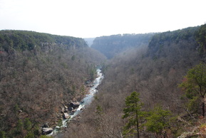
 There are just a few places in Eastern Alabama worthy of hiking at, and Little River Canyon is definitely one of them. The canyon is over a dozen miles long, and it is bordered by the Sand Mountain Ridge to its west, and the Lookout Mountain Ridge to its east. There are lots of interesting rock formations around the canyon, and in the canyon, while Little River rushes through with whitewater. Little River Falls is the biggest waterfall on Little River, although there are small slides in its course too. This hike occurred on Saturday, March 22nd, 2014. My plans were to hike the Little River Falls Trail to Martha's Falls out and back, then drive down Little River Canyon Parkway (AL Route 176), stop by each of the overlooks, hike the Beaver Pond Loop Trail, and finally, hike the Eberhart Trail from Eberhart Point to the bottom of the canyon and Little River. 1st Trail: Little River Falls Trail to Martha's Falls R/T Length of Trail: 1.5 Miles Duration of Hike: 1 Hour Type of Hike: Out and back Difficulty Rating: 2 out of 10; Pros: Easy trail in the Little River gorge Cons: A scramble at the end of the trail to Martha's Falls may present some slight difficulties - care needs to be exercised at this point; the trail is not very well-marked Points of Interest: Little River Falls (at trailhead) - 9 stars; Martha's Falls - 2 stars Trail Blaze Color(s): None Best Season(s) to Hike: Spring Fees: None Beginning Point: Little River Falls parking lot on AL Route 35 Directions: From Rome, GA: Take GA Route 20 West. Once you cross the Alabama/Georgia state line, the road changes to AL Route 9. Around 5 miles from the Alabama/Georgia state line, you will reach a junction with AL Route 35. Take a right onto AL Route 35 North, pass through the community of Gaylesville, and around 14 miles from the junction with AL Route 9, you will reach the Little River Falls Parking Lot and Trailhead. It will be on your left, just before the bridge over Little River. Summary Details I usually don't go hiking in Alabama. There are not a lot of mountains or scenic places. However, when I recently ran upon Little River Canyon, I decided to give it a try. I hoped it wouldn't be the same as what happened on my recent trip to Cherokee Rock Village near Leesburg, AL. I had payed $3 at Cherokee Rock Village for nothing, and there were no good trails, and even getting up to a good view was hard. There were a couple other places in Alabama I have been to over the past three years, including Desoto State Park near Valley Head, Cheaha State Park, near Heflin, Monte Sano State Park near Huntsville, and the Walls of Jericho, near Skyline. I was satisfied with my experiences in most of these places. That said, Little River Canyon quickly got added to the places in Alabama I liked - even more by the views then by the trails. Since Little River Canyon National Preserve is huge, and the trails are overlooks are far apart from each other, I was brought to the fact that I had to drive from trail to trail, and from overlook to overlook - something I usually do not prefer to do, but did not mind this time. Also, I had a hiking buddy with me this time, which does not happen too often. The first trail was from the Little River Falls parking lot. The trail led to Martha's Falls, more like a short wide slide, and lasted 3/4 mile. However, before starting the trail, I went down the Little River Falls boardwalk to take a look at Little River Falls. It was a wide waterfall, but it was not very high. It was still nice to look at. I did not want to lose any time, so I went to the trail right away. There was a sign "Martha's Falls ^ ". The trail started off very pleasant, going above the river bank along some rock outcrops. It kept going slightly up and down, but nothing hard at all. Around 1/4 of a mile from the start, you will come to a small rock outcrop overlooking some rapids on the river. There are several man-made trails that branch off left and right, but it is pretty easy to figure out where the main trail goes, as it looks more maintained. There are remnants of some very old green and yellow blazes on trees, but it would be extremely hard to notice them at all. You will cross a small stream at one point, but it is not a problem at all - just step over it. At around 1/2 mile, you will reach a small sign on a tree that has a hiker symbol and an arrow that said keep going straight. To the left went a small connector trail to the Martha's Falls parking lot, which was just south of the Little River Falls parking lot on AL Route 35. Shortly after this connector, there was another stream, a bigger one this time. However, if you are careful, it is nothing to even think about. I just stepped over using the rocks. From here, it is a short couple hundred feet down the slope to the riverbank. There is nothing extremely hard in this descent. However, it is steep. There are lots of rocks and some trees to get your holding on. There was some pressure on my ankles on this descent. Once I reached the bottom, I immediately saw what they called Martha's Falls. It was not really a waterfall, but rather a series of rapids. I stayed for a little while there, contemplating the surroundings. If not for the crowds on this trail, it seemed to have a nice wilderness setting. The climb back up was faster than I thought it would be. It felt easier too. However, some minor scrambling was needed. The rest of the trail went by fast too, and before I knew it, I was back at the Little River Falls trailhead. It was time for the next hike. Summary 2nd Trail: Beaver Pond Loop Trail R/T Length of Trail: 2 Miles Duration of Hike: 1.25 Hours Type of Hike: Lasso Difficulty Rating: 1 out of 10 Pros: Very easy stroll in the woods that is good for children or elderly people Cons: None Points of Interest: The beaver pond Trail Blaze Color(s): None Best Season(s) to Hike: Year-round Fees: None Beginning Point: Lynn Overlook on Little River Canyon Parkway (AL Route 176) Directions: From the first trailhead, take a left onto AL Route 35. Pass over the bridge, and take a left onto AL Route 176. Drive 1 mile to the Lynn Overlook entrance. Details My plan was to stop at each of the overlooks on Little River Canyon Parkway. Well the second one was called "Lynn Overlook", and the parking lot was in a large glade. The views were not as spectacular as farther down the canyon, but it was still nice. The power lines pass through here as well, crossing the canyon onto the opposite rim. You can start the Beaver Pond Trail from this overlook. Go under the power lines, cross AL Route 176, and you will see a small dirt and gravel pullout just to the left of the power lines. You will see an information kiosk. This is the start of the Beaver Pond Trail. The map of the trail is on the kiosk. About 1/4 mile from the trailhead, the loop section of the trail started. It did not matter much whether I went left over the creek or forward, but forward was a little quicker to the Beaver Pond. This trail was pretty much flat. It crossed the creek eventually over a footbridge, and entered a thick pine forest. In this pine forest, there was another junction. It was now 1/2 mile since the trailhead. To the right went a spur trail to the Beaver Pond, 0.1 mile long. To the left the loop continued, and it said 1 mile to the trailhead. That would be the return route. First, I quickly checked out the Beaver Pond. It was a marsh more than anything, but there were some signs that beavers might have created it. I don't know if there is a lot of beavers in this area, but it is possible. You will also notice a private residence to your south (left from the Beaver Pond). Back on the main trail, keep going counter-clockwise along the loop. Soon, I exited the pine forest, crossed another creek, and kept hiking on the flat terrain. So far, this trail was pretty boring. A short descent, and another footbridge over the same creek. Another 1/4 mile, and I crossed the 4th and last footbridge, ending the loop part of the hike. From here, I hiked the remaining 1/4 mile to the trailhead. I wasn't' really impressed with this trail. It was just a flat, easy trail through a southern forest. I had one more trail to hike, and it was supposed to be the hardest, according to the descriptions. However, before I reached it, I stopped at several overlooks of the canyon, which were more impressive then the first one. Summary 3rd Trail: Eberhart Trail R/T Length of Trail: 1.5 Miles Duration of Hike: 1.25 Hours Type of Hike: Out and back Difficulty Rating: 4 out of 10 Pros: The descent from Eberhart Point follows an old road that provides a relatively easy route into the canyon without a large degree of rockiness Cons: The trail, while short, is very steep Points of Interest: Eberhart Point Overlook (at trailhead); the Little River in the canyon Trail Blaze Color(s): None Best Season(s) to Hike: Winter Fees: None Beginning Point: Eberhart Point trailhead on Little River Canyon Parkway (AL Route 176) Directions: From the previous trailhead at Lynn Overlook, take South AL Route 176. Drive 10.5 miles following AL Route 176 to a large sign "Eberhart Point". This is the trailhead. Details So far I hiked around the top of the canyon's rims, and stopped at each overlook. However, I had not hiked to the bottom yet. That was my goal for this final trail. The trail is called the Eberhart Trail, and leads to Eberhart Point Overlook, before going down into Little River Canyon. The trail is paved as it leads to two overlooks of the canyon from Eberhart Point. Don't expect that luxury too long. The paved path ends at the second overlook. From here, there is a short shortcut trail that goes through the woods onto the main trail. The main trail is actually an old road. There used to be a building and a skylift at the bottom of the Eberhart Trail, and this road led there. The road was pretty steep and eroded, but it had some erosion control wooden planks. They did not seem to help much though. While the trail was steep, it was barely rocky, mainly just dirt, which helped a lot. After a couple switchbacks, I reached the bottom of the canyon. The trail passed through a small flat area, and it reached Little River. The river was beautiful here. The way it flowed between the steep canyon walls reminded me of a decent canyon in the West US. The ones in Georgia looked different. I do not know how, they just looked different. Maybe I am just tired of visiting old canyons over and over again. Duh. That did not matter much, at least the scenery was beautiful. This hike officially deserved a good position for Alabama. Now, it was time to get back up those nearly 400 feet in just 3/4 mile. It was pretty steep. Huff, puff. I hike harder trails than this, but it was a pretty hard ratio for this area anyway. But, I made it up faster then I thought I would. Overall, I would say this is the best place in Alabama I hiked at so far. Even in Alabama there are beautiful spots, unique to the southern Appalachians. If you live in Huntsville, Gadsden, Birmingham, Rome, or nearby areas, I would highly recommend you visit this park. There are not a lot of places you can find in this area that are similar to this. Below are my pictures from this hike. Variations Besides skipping one of the trails described here, there are no variations. Bonus Stops The Canyon Mouth Trail is a 2-mile hike along the Little River at the lower end of the canyon, showcasing some of the beauty found in the canyon. Pictures
4 Comments
11/30/2015 06:10:41 am
Great Information, Thanks For Sharing It, I also Was planning to visiting Alabama Attractions with my family, I think it was an awesome place for vacations with family.
lisa slusher
7/14/2016 08:32:55 pm
Thank you for this detailed description of your hike! Have a group going there this weekend. Thanks for all the info! 8/2/2022 12:28:41 am
Instagram düşmeyen takipçi satın almak güvenilir adresler üzerinde tercih edildiği takdirde istenilen sonucu oluşturuyor. Sizlerde istediğiniz sonuçlara hızlı bir şekilde adresimiz ile ulaşım sağlayabilirsiniz.
That said, Little River Canyon quickly got added to the places in Alabama I liked - even more by the views then by the trails. Since Little River Canyon National Preserve is huge, and the trails are overlooks are far apart from each other, Thank you for sharing your great post! Leave a Reply. |
About MeMark Oleg Ozboyd Dear readers: I have invested a tremendous amount of time and effort in this website and the Georgia Waterfalls Database the past five years. All of the work that has gone in keeping these websites updated with my latest trip reports has almost been like a full-time job. This has not allowed me to pick up a paid job to save up money for college, and therefore, I I've had to take out loans. If you find the information on this website interesting, helpful, or time-saving, you can say "thanks" and help me out by clicking the button above and making a contribution. I will be very grateful for any amount of support you give, as all of it will apply toward my college tuition. Thank you!

Coming in 2022-2023?
Other Hiking WebsitesMiles HikedYear 1: 540.0 Miles
Year 2: 552.3 Miles Year 3: 518.4 Miles Year 4: 482.4 Miles Year 5: 259.9 Miles Archives
March 2021
Categories
All
|
 RSS Feed