HIKING THE APPALACHIANS AND BEYOND
  • Home
  • Trail Reports
    • Best Hikes
    • Hikes with Scenic Views
    • Hikes with Water Features
    • Alabama
    • Georgia
    • Florida
    • North Carolina
    • South Carolina
    • Tennessee
    • Vermont
    • Virginia
  • Map
  • Hike List
  • Testimonials
  • Resources
  • Contact Us
  • Southeast Nature Society
    • Our Team
  • Georgia Waterfalls Database

Sprewell Bluff Park: Upper Flint River Trail, Thomaston, Georgia

5/15/2017

0 Comments

 
Picture
Undammed for nearly two hundred miles until Lake Blackshear near Cordele, the Flint River is one of central and south Georgia's most beautiful large rivers, flowing through several swamps from its headwaters in metro Atlanta. One of the highlights of the river is Sprewell Bluff, a 150-foot bluff towering above the Flint near Thomaston. Other hills and bluffs form a surprisingly narrow and deep gorge on the Flint River in the next few miles upstream. In the 1960s, the splendor of the Flint River in the vicinity of Sprewell Bluff and Thomaston was threatened by the Army Corps of Engineers' proposal of building a dam at Sprewell Bluff, but thankfully, the dam construction proposal was vetoed  in 1974 by President Jimmy Carter. The area around Sprewell Bluff became a Georgia State Park in the early 1990s, and today, it is managed by Upson County. Today, a well-developed trail system, gorgeous roadside overlook, campground, and trading post are to be found in Sprewell Bluff Park. This hike occurred on Friday, April 14th, 2017. My plan was to hike the entire Upper Flint River Trail out and back from Sprewell Bluff Road, although I had to shorten my hike due to a late start. 

Summary

R/T Length of Trail: 1.7 Miles
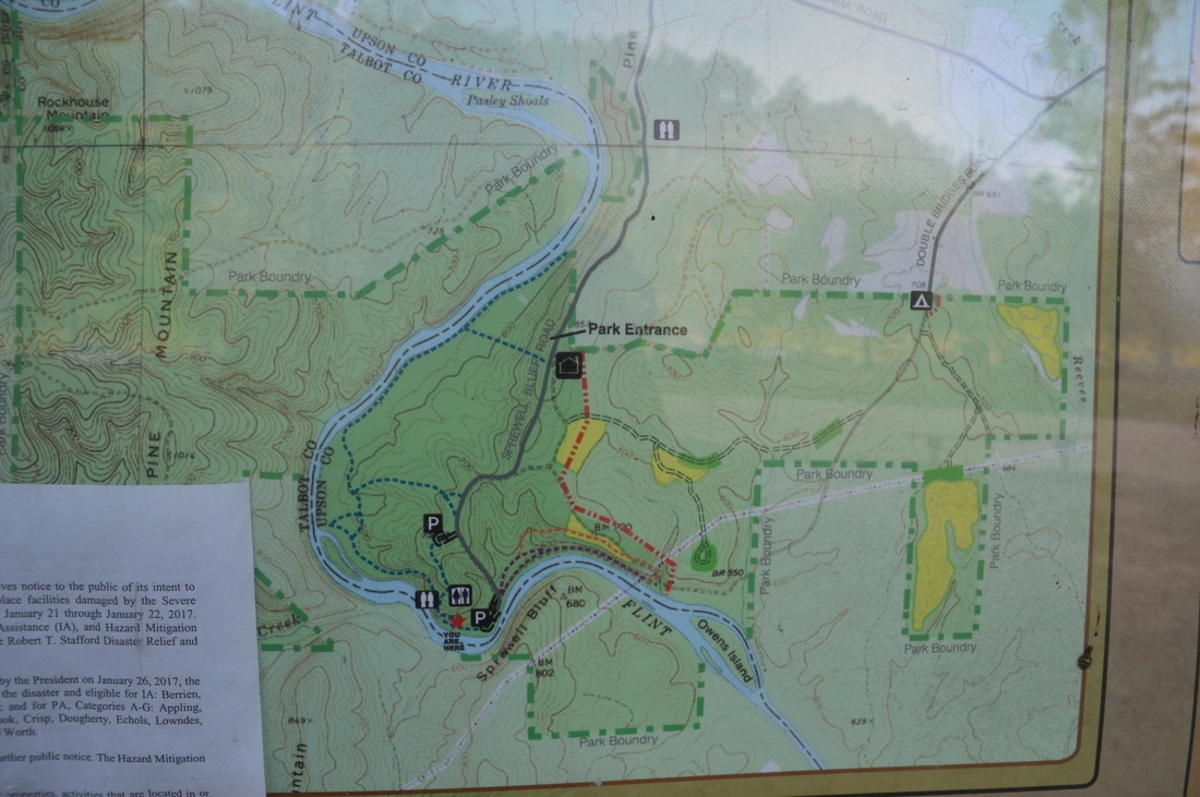
Duration of Hike: 1:05 
Type of Hike: Out and Back 
Difficulty Rating: 1 out of 10 
Total Elevation Gain: 270 Feet
Pros: Well-groomed trail that is suitable for families
Cons: None
Points of Interest: Sprewell Bluff and other bluffs along the Flint River; Flint River Double Overlook; Flint River Island
Trail Blaze Colors: Upper Flint River Trail - Blue
Best Seasons to Hike: Year-round 
Fees: The entry fee for Sprewell Bluff Park is $5 per car. 
Beginning Point: Flint River Trailhead
Directions from Thomaston, GA: From the intersection of GA 74 (Main Street) and US 19 (Church Street) in downtown Thomaston, follow GA 74 West for 5.7 miles, and then, turn left onto (South) Old Alabama Road. Continue on Old Alabama Road for 6.6 miles to its terminus at the Flint River Trailhead in Sprewell Bluff Park. You will enter the park about 4.6 miles from GA 74. At the park entrance, there is a trading post to the left and an incredibly beautiful overlook of the Flint River Gorge to the right. 

Map

Picture
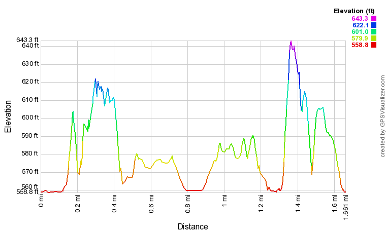
Click here to download a track of this hike. 

Details

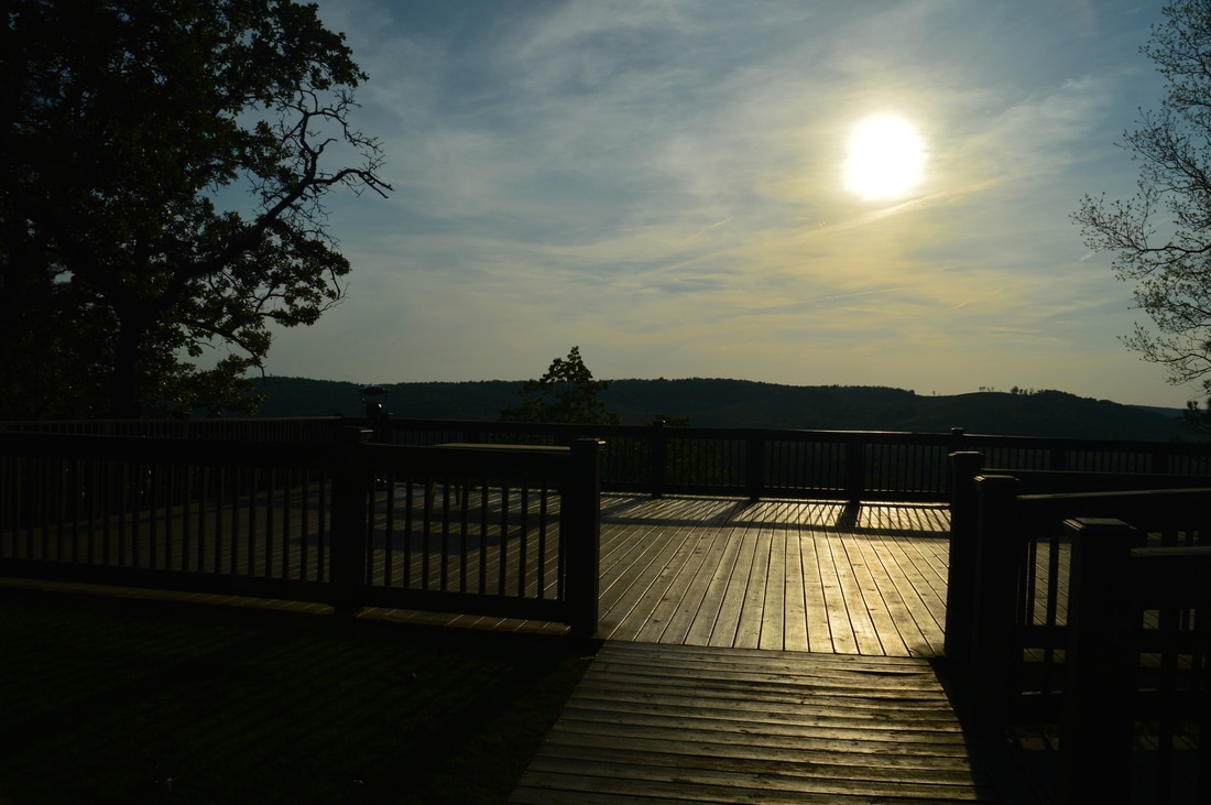
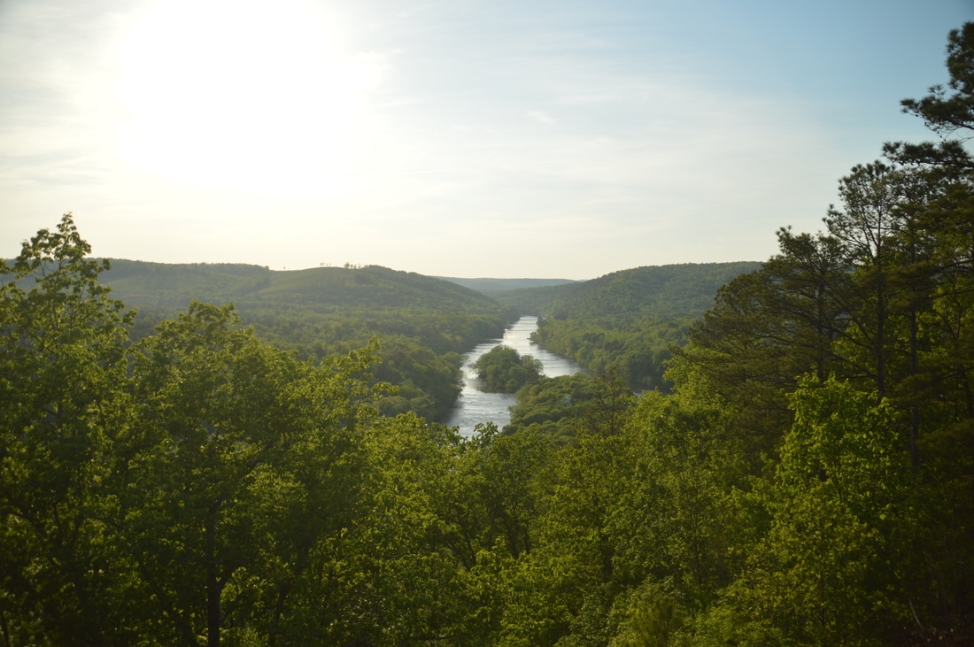
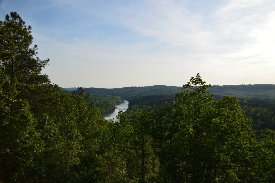
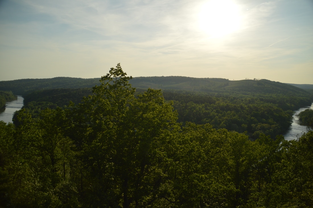
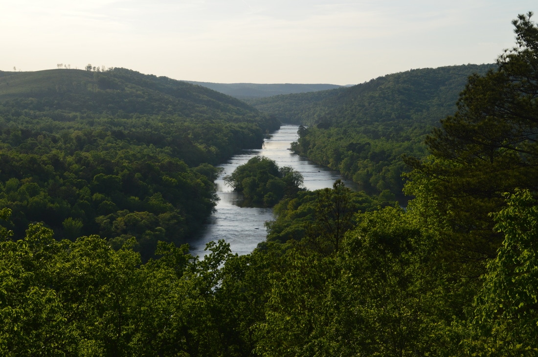
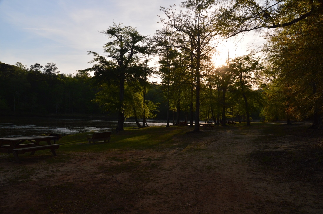
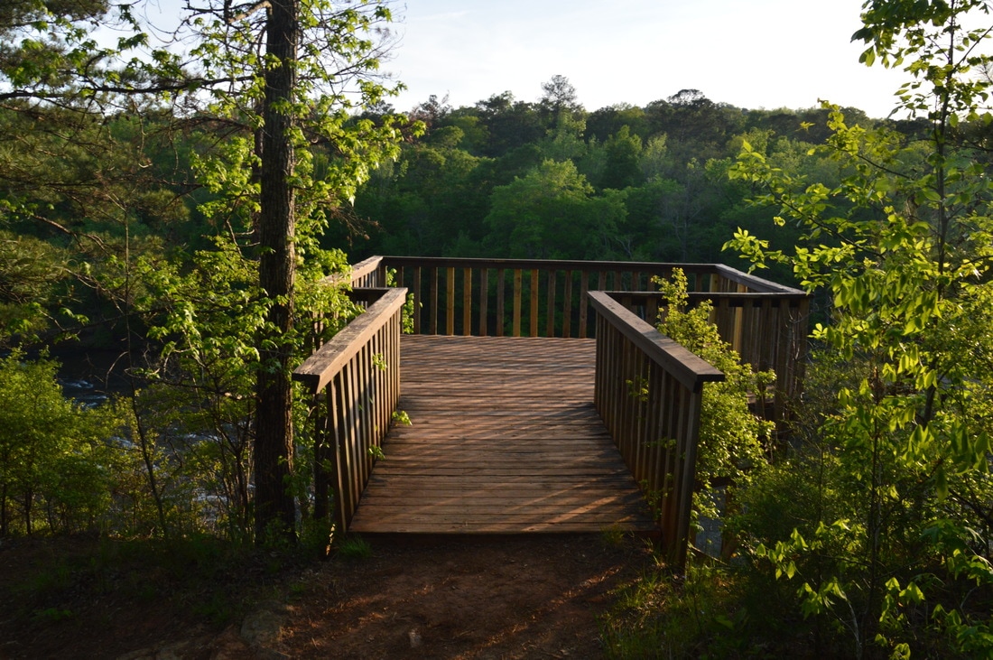
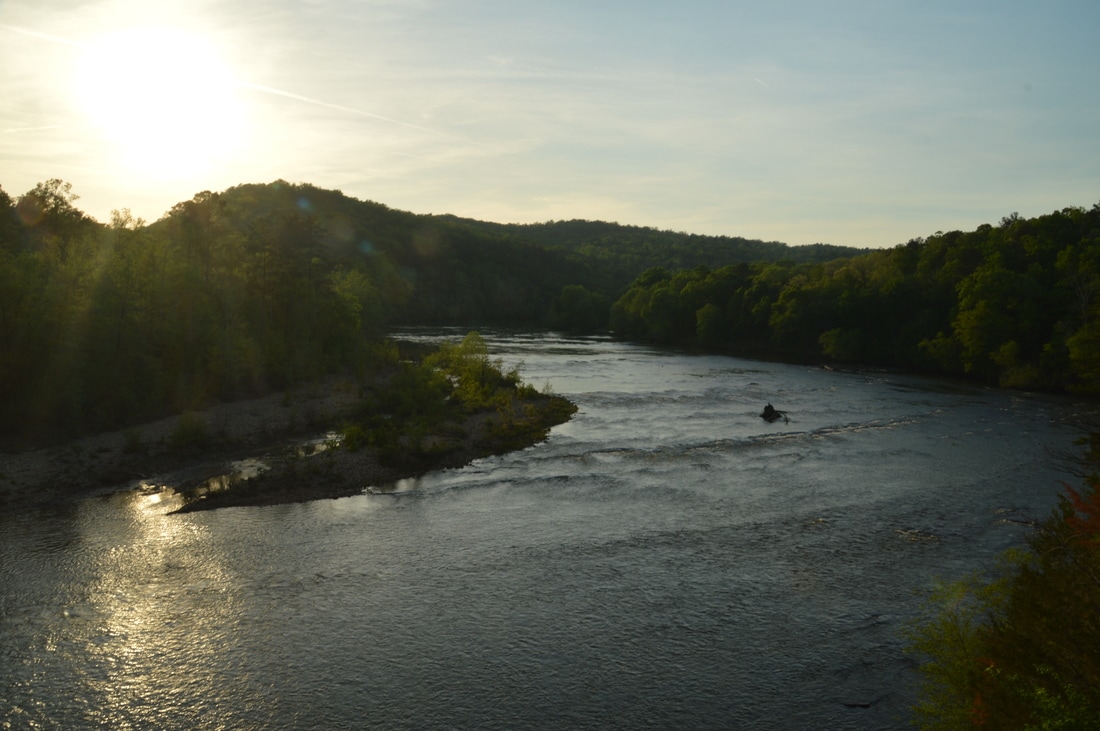
Sprewell Bluff Park is one of central Georgia's best hiking destinations, due to the beauty of the Flint River gorge. Besides the hike, the roadside overlook at the park entrance is noteworthy, as it provides one of the best views that I have seen south of Atlanta. The panorama of the Flint River snaking through the hills is hardly different from a mountain gorge view. A broad observation deck lets visitors enjoy this easy-to-access view. 

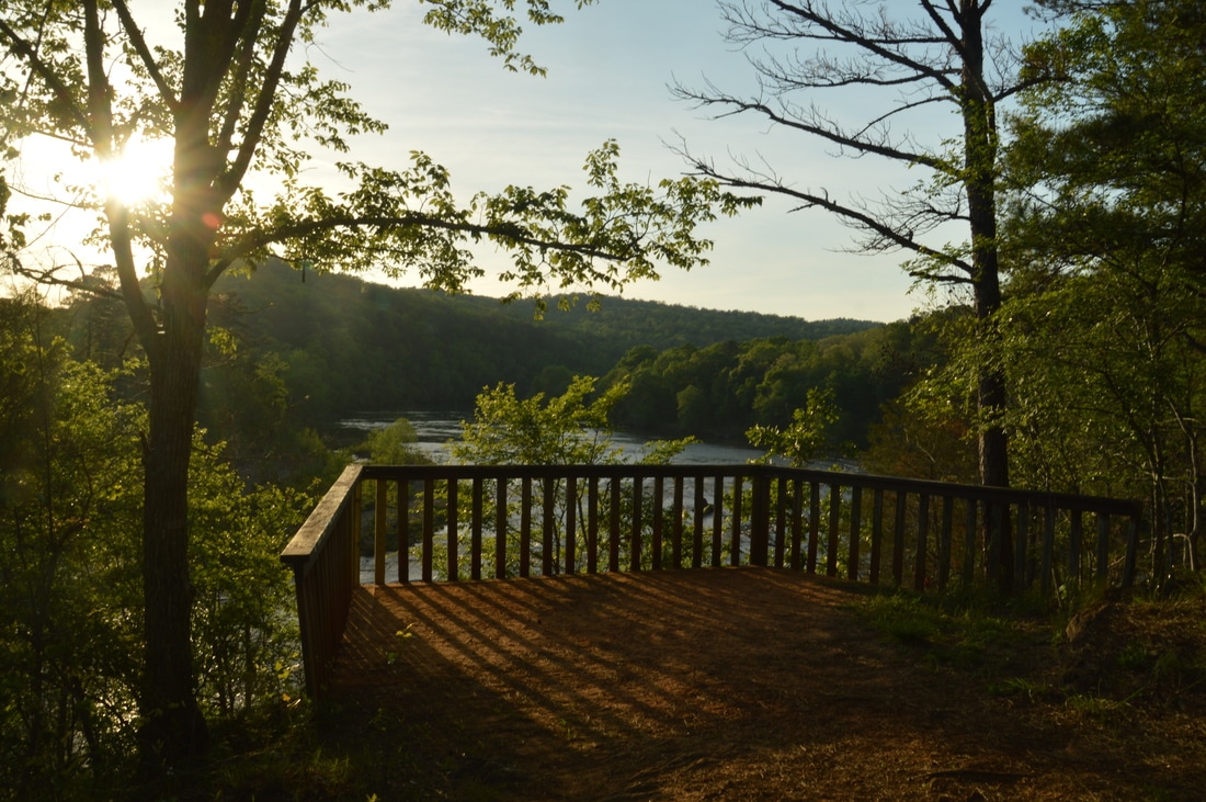
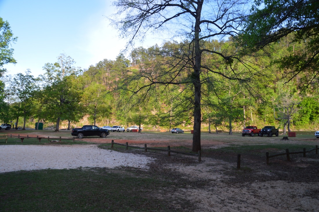
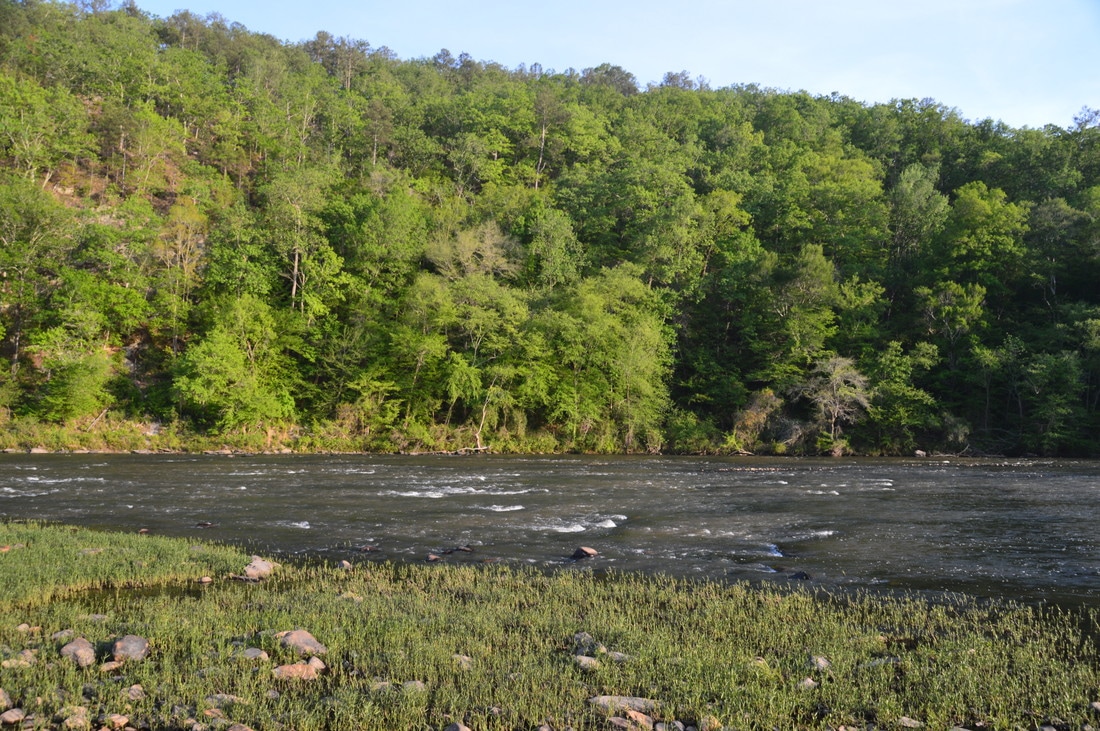
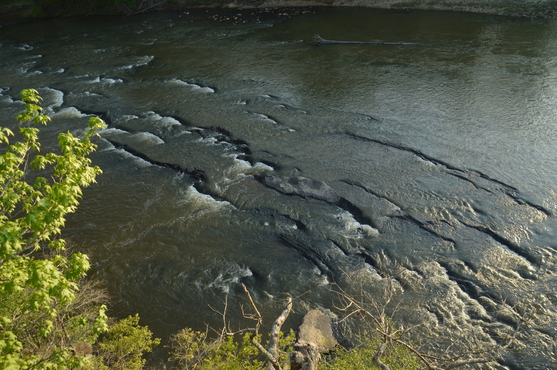
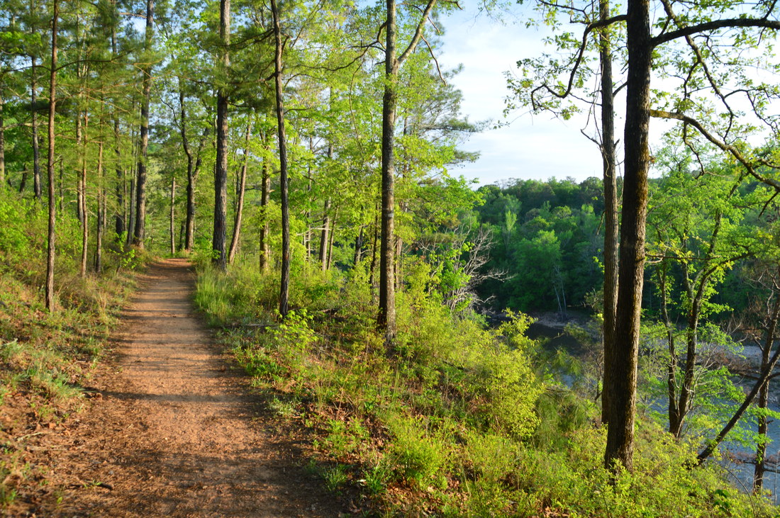
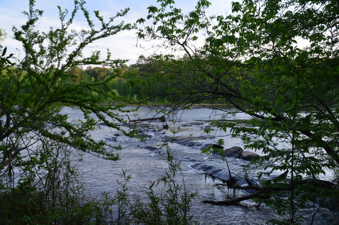
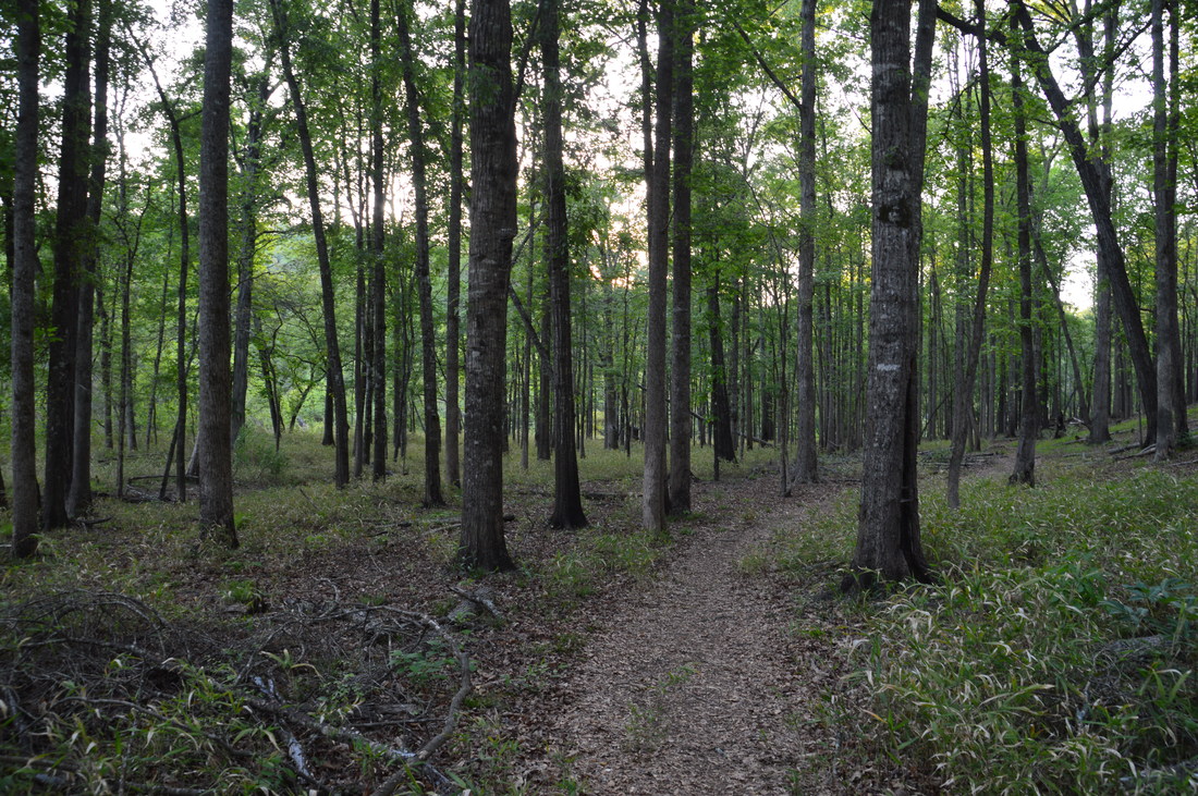
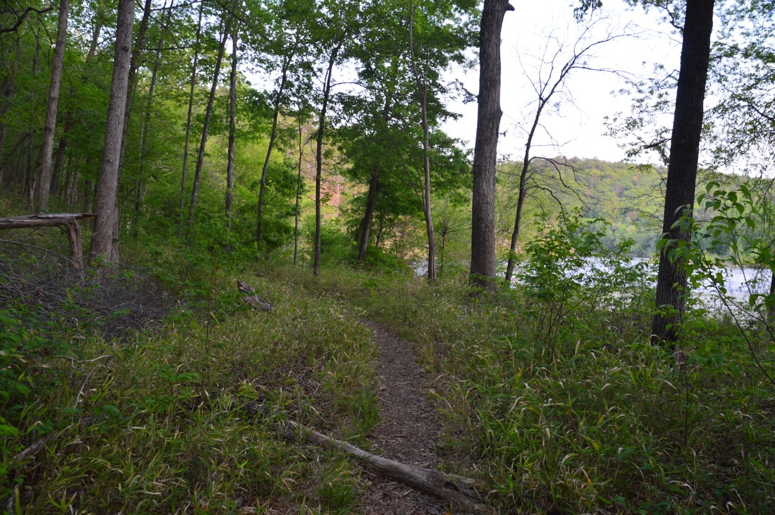
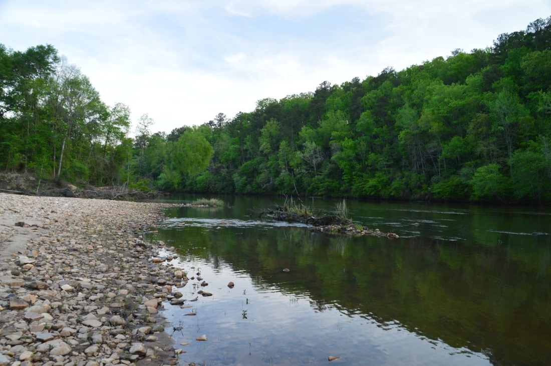
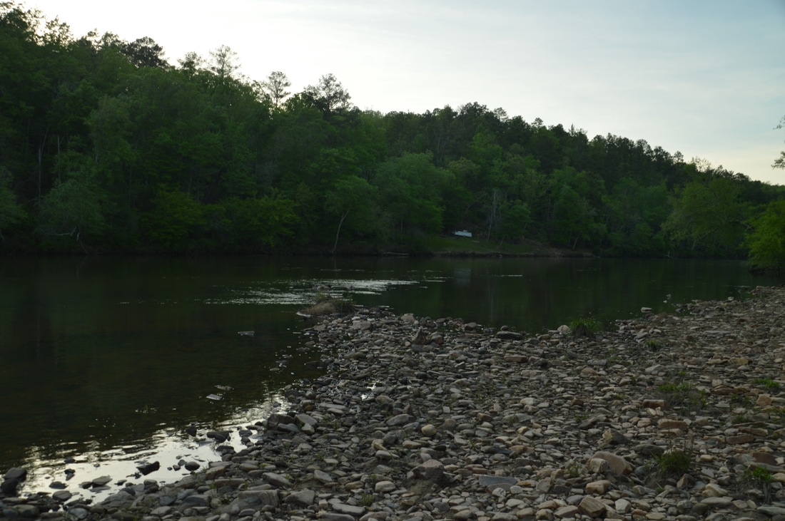
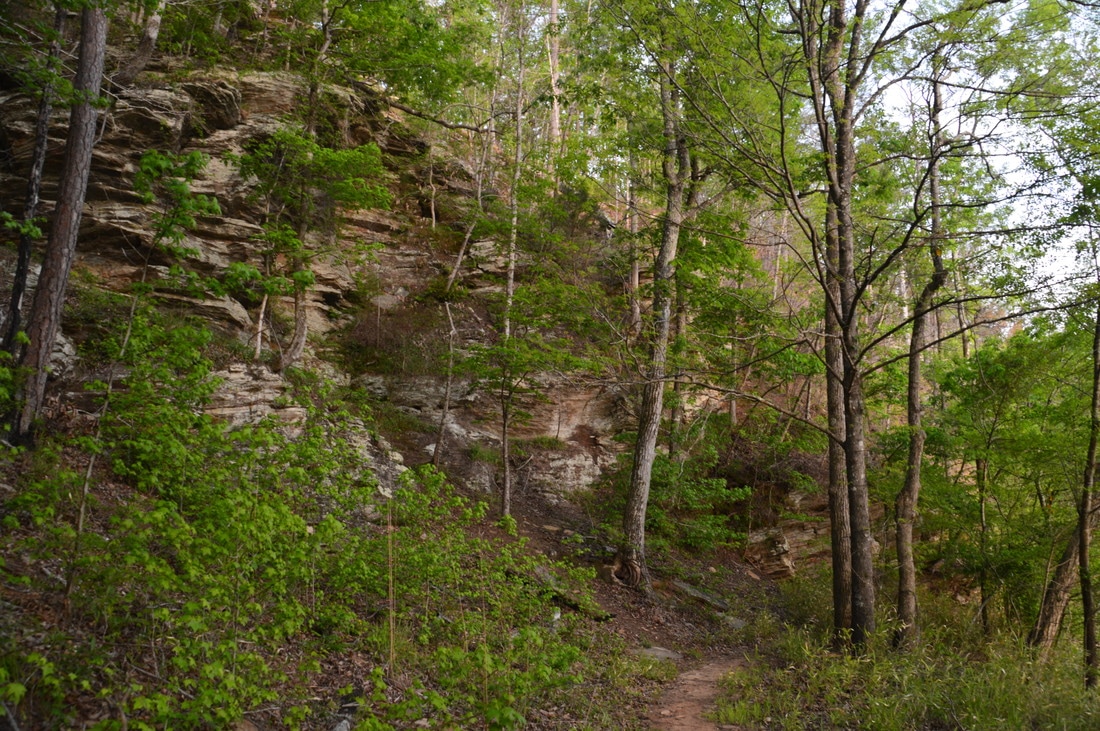
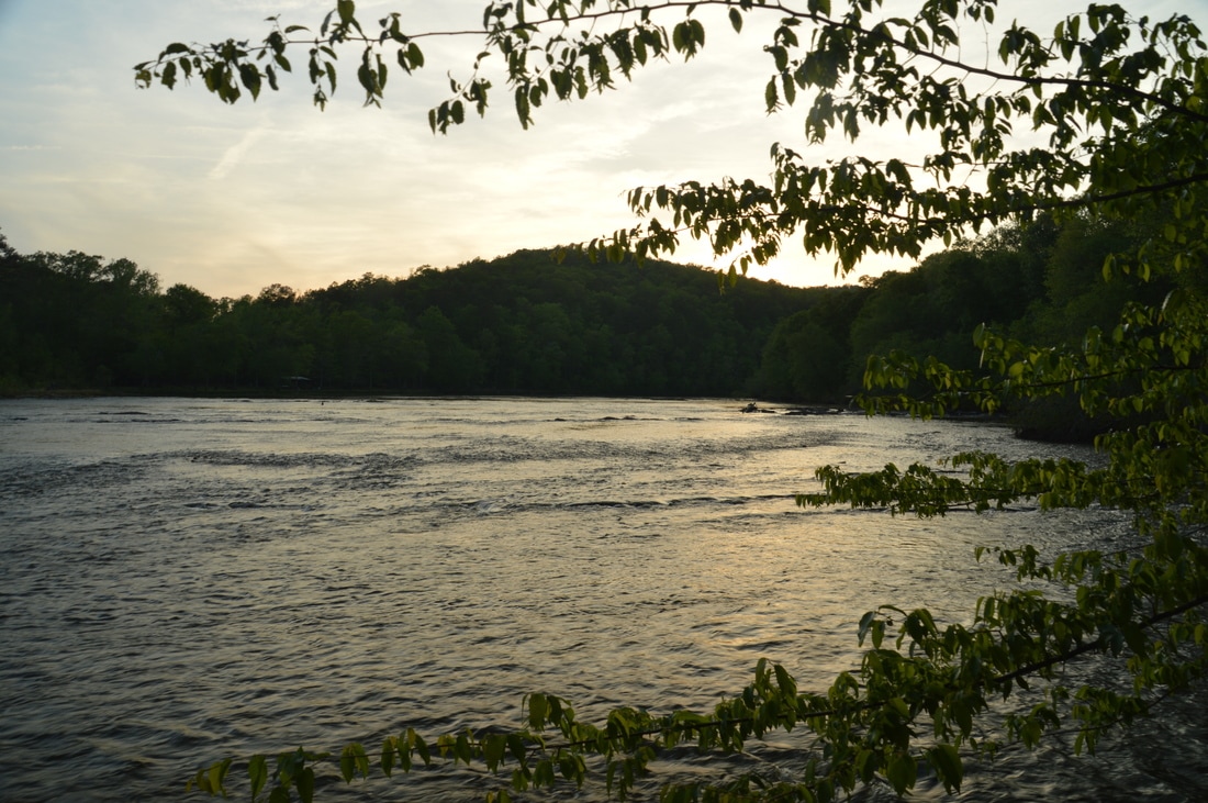
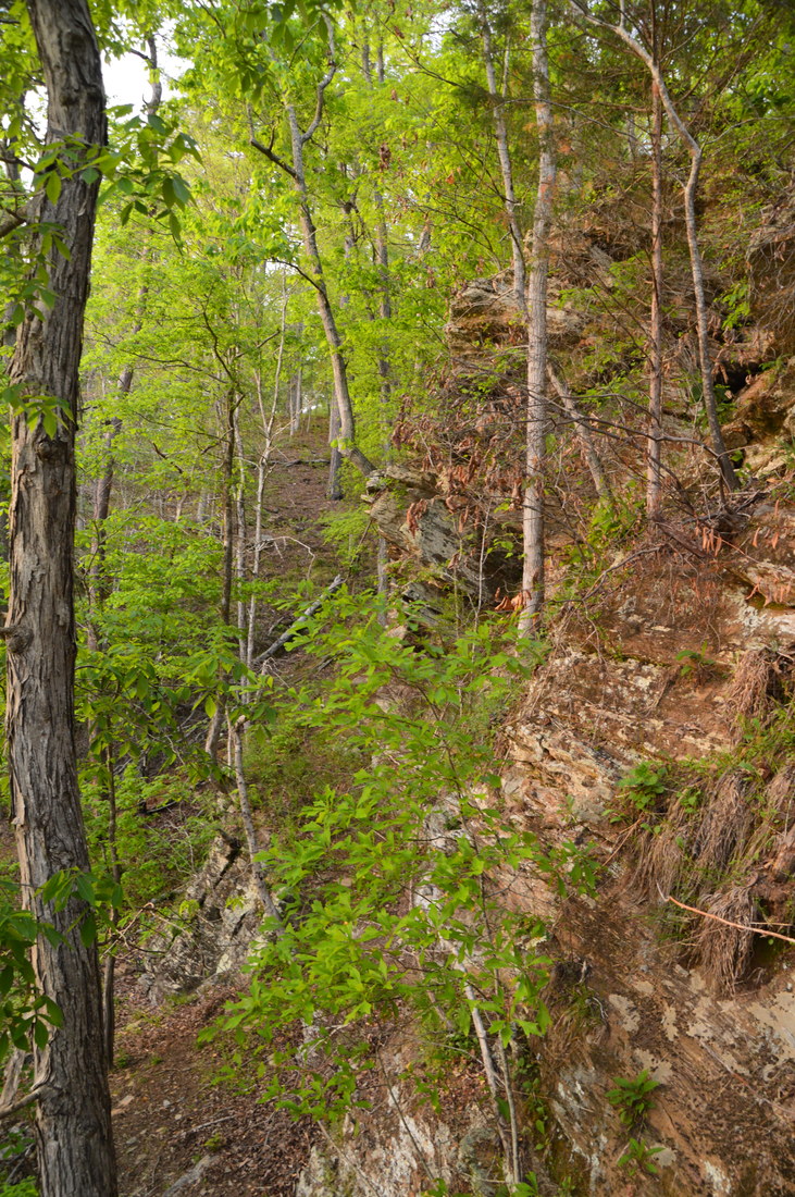
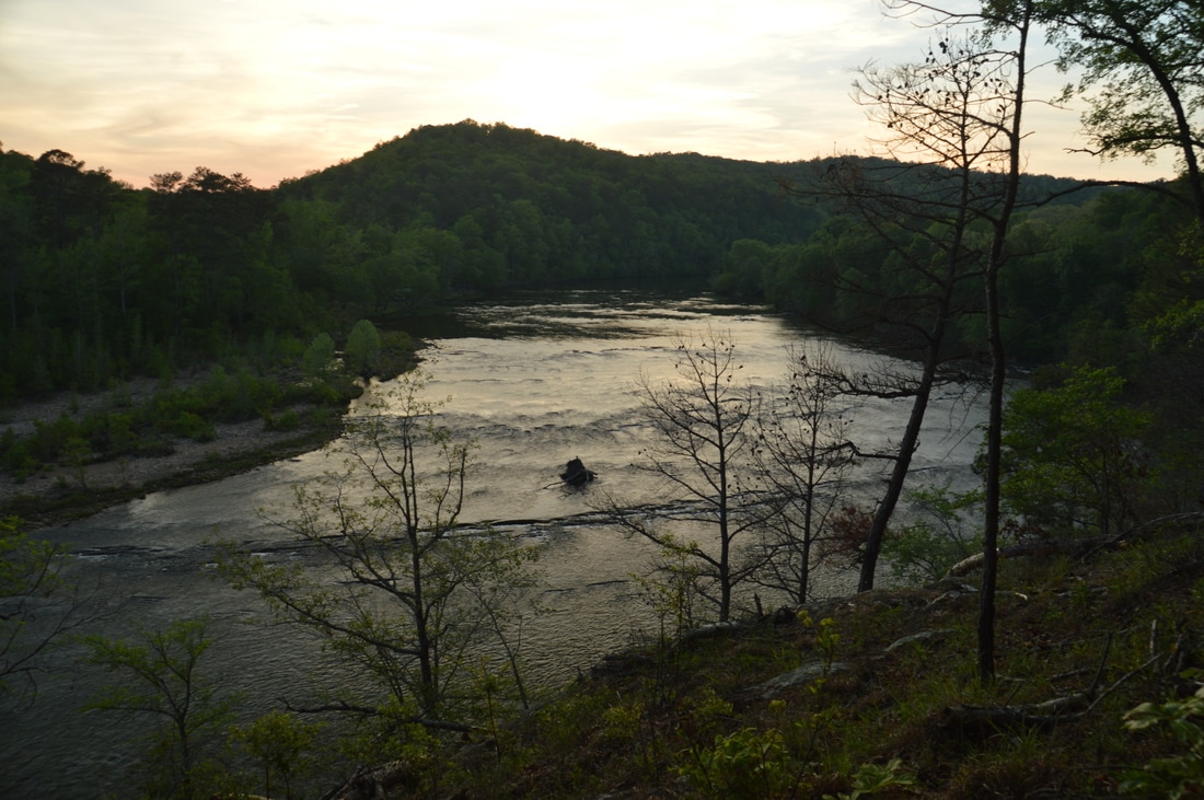
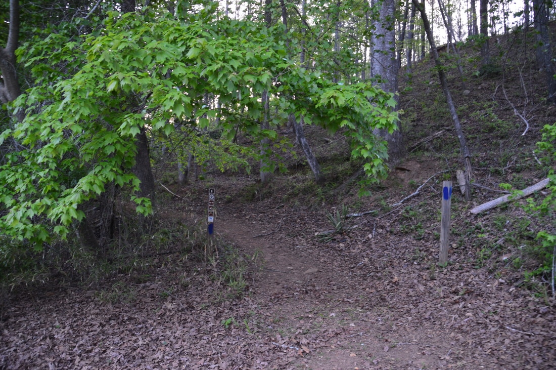
The hike itself begins at the Flint River trailhead at the end of Sprewell Bluff Road. Directly across the river from the parking area, Sprewell Bluff is quite a sight as it towers dramatically above the river. Two trails leave the large trailhead parking area: the Longleaf Pine Trail heads east/northeast and downstream, and the Upper Flint River Trail heads west and upstream. A satisfactory day hike can be made out of the full length of both trails. For the shorter hike that is described here, pick up the the Upper Flint River Trail at the trailhead kiosk near the far end of the parking area. The wide trail initially stays close to the river, passing through the picnic area. When the picnic area ends at 0.1 miles, there is a sign that warns about river hazards. The distinct trail bears right, gently ascending away from the river to bypass a line of sheer bluffs. Near the top, an alternate trail from the parking area ties in from the right. This trail can be utilized on the way back for a slight variation in the hiking route. Meanwhile, bear left and at 0.2 miles reach a pair of observation areas overlooking the Flint River from the top of the bluffs. 

The first observation area is complete with a deck that provides a commanding view of the wide Flint River upstream, along with a small island in the middle. Directly below the deck is a broad set of shoals that stretches across the entire river. The second observation area (that is only a few feet farther) is equipped with just a fence, but this upstream view is more tree-framed and possibly more photogenic (see header photo). Beyond the overlooks, the trail continues ascending through open woods. At 0.25 miles, there is an unsigned junction with a blue-blazed access trail that leaves to the right, leading to a secondary ridgetop trailhead on Sprewell Bluff Road. Make sure to continue straight on the Upper Flint River Trail, which was not blazed for some reason when I did this hike. There are several more bluff-top river views through the sparse trees. Shortly afterwards, the trail descends moderately back down to the river, reaching it at 0.45 miles. A scramble path leads left to the base of the bluff line, but for now, bear right to continue on the trail past another area of shoals and into lush bottomland. 
Picture
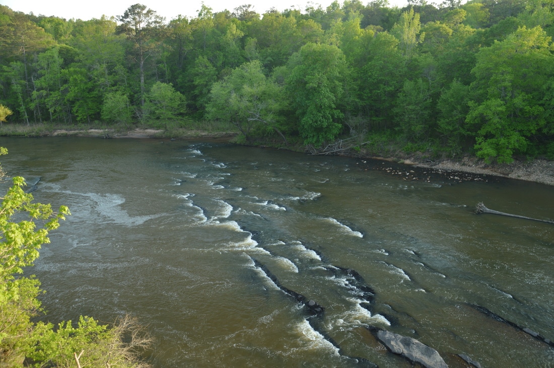
The Flint River near Sprewell Bluff features several sets of shoals such as this one.
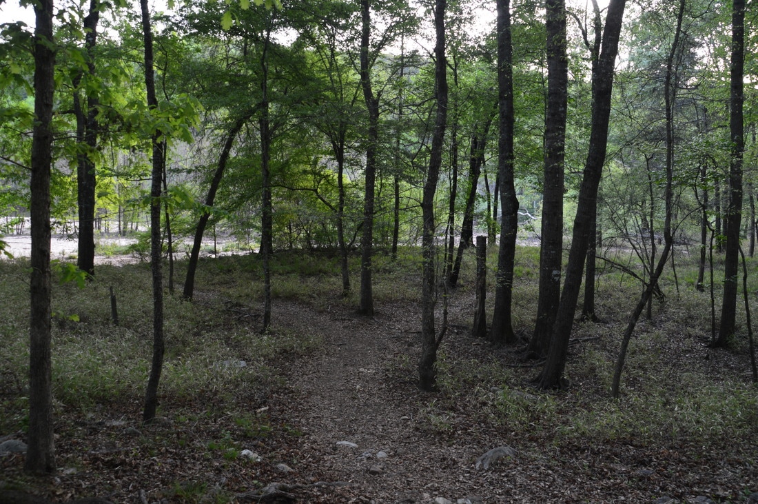
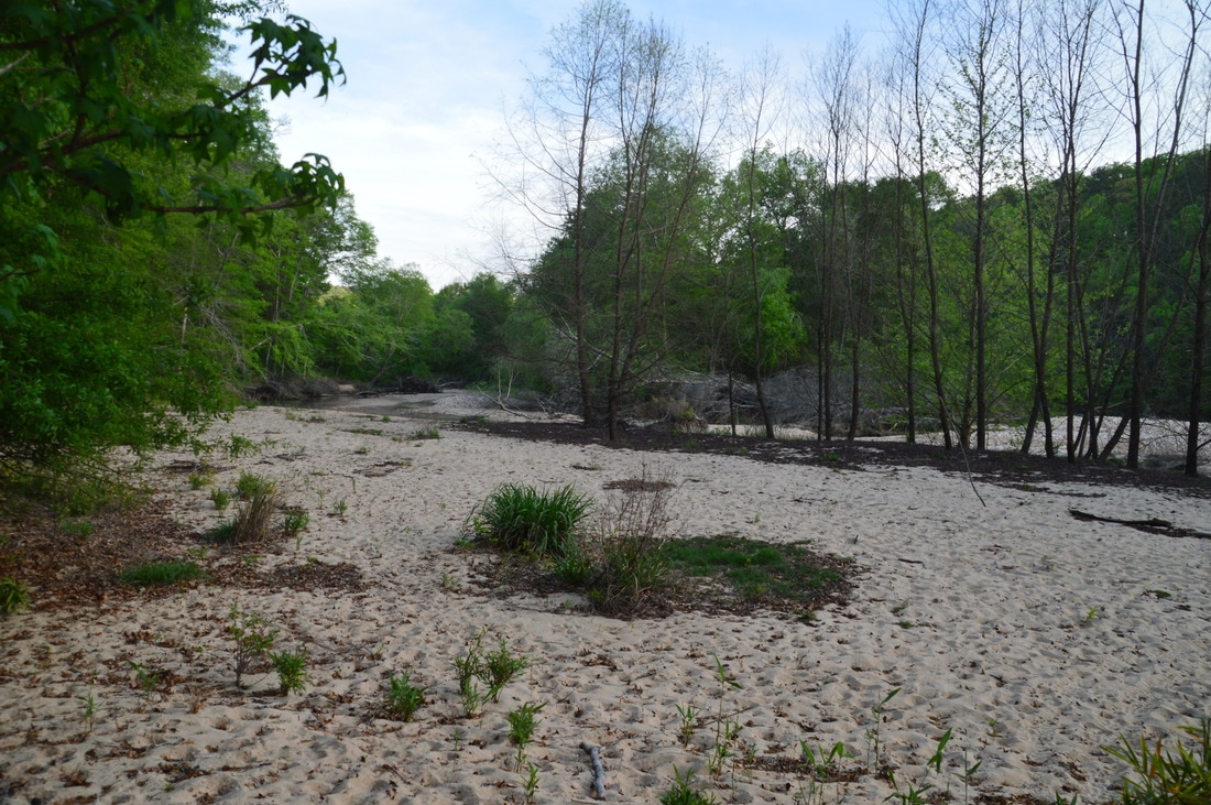
At 0.7 miles, there is a disorienting intersection that is marked by a kiosk, which on this day had no information on it. ​The trail that bears right at the kiosk is the continuation of the Upper Flint River Trail, while the trail that bears left is a spur trail to a large island and beach-like area on the Flint River. Originally, my plan had been to hike to the entire Upper Flint River Trail, but due to time constraints, I had to limit myself with turning around at the island. Thus, if you do not wish to extend the hike, then take the spur trail left, reaching its end near the river at 0.85 miles. Next to the Flint River is a broad sandy area in the picturesque floodplain. From the end of the trail, it is possible to rock hop or wade in low water levels across the small right channel of the Flint River and walk down a rocky "beach" to the edge of the river's placid waters. In high water levels, the rocky beach is likely going to be submerged. This is a beautiful and fairly remote location. Remoteness is difficult to find on central Georgia's hiking trails, which is one of the reasons why I consider this short section of the Flint River particularly special.

From the island, retrace your steps all the way back to the point where the trail reaches the river near a line of bluffs. This time, instead of climbing away from the river right away, continue straight on a narrow path that leads to the base of the impressive bluffs. Several twisting paths provide routes to the top amidst the bluffs, but please do not use any of the paths to prevent erosion. Returning to the trail, continue following it back toward the trailhead, passing the double observation deck. At the intersection near the end, you can bear left on the hillside trail that stays above the picnic area. Passing a pair of carsonite trail markers, you will reach the trailhead and conclude the hike at 1.8 miles. 

Mileage

0.0 - Sprewell Bluff Trailhead
0.2 - Flint River Observation Areas 
0.45 - Bluffs
0.85 - Sandy beach and island on Flint River

Variations

Hike the full Upper Flint River Trail - 4.6 Miles 
Hike both the full Upper Flint River Trail and the Longleaf Pine Trail - 6.2 Miles

Bonus Stops

Around 30 minutes from Sprewell Bluff is Franklin Delano Roosevelt State Park, Georgia's largest state park. There is an abundance of hiking trails in the park, including the Wolfden Loop that passes numerous small waterfalls and the Dowdell Knob Loop that visits an overlook at the park's highest point. 

Pictures

Videos

0 Comments


Leave a Reply.

    About Me

    Mark Oleg Ozboyd
    I'm an avid outdoor explorer and a hobbyist landscape photographer. I'm 21 years old and have been hiking since 2011. Originally based out of Atlanta, Georgia, I started out by occasionally hiking short trails throughout well-known Georgia State Parks. During 2012 and 2013, I began to expand my trips into adjacent states, as well as into the wilder National Forest areas rather than just State Parks. Throughout the years that followed, as I slowly ran out of popular hiking trails in my area, I began to search for and hike in more seldom-visited areas. Today, you can find me out in the woods every weekend, whether it's on an official trail or bushwhacking through cross-country terrain without any paths. I now attend Washington & Lee University and am exploring Virginia and West Virginia. My other hobbies include chess, science, old music, and meteorology. I have 3 years of amateur weather forecasting experience, having studied a lot of meteorology basics over the years. I am also a student at European School of Music where I learned that music and nature have a lot in common. Listening to good music inspires me to capture nature's beauty on the camera in different aspects that also make me recall many beautiful music pieces that I've heard.​


    Dear readers: I have invested a tremendous amount of time and effort in this website and the Georgia Waterfalls Database the past five years. All of the work that has gone in keeping these websites updated with my latest trip reports has almost been like a full-time job. This has not allowed me to pick up a paid job to save up money for college, and therefore, I I've had to take out loans. If you find the information on this website interesting, helpful, or time-saving, you can say "thanks" and help me out by clicking the button above and making a contribution. I will be very grateful for any amount of support you give, as all of it will apply toward my college tuition. Thank you! 

    Enter your email address to subscribe for trail reports:

    Delivered by FeedBurner


    Picture
    Coming in 2022-2023?

    Other Hiking Websites

    DWHike's Adventures
    Florida's Natural Wonders
    Florida Trailblazer
    Meanderthals
    Mountain Images
    by Bernie Boyer

    North Carolina Waterfalls with
    ​Kevin Adams
    Take-a-Hike!
    Tennessee Landforms
    Waterfall Page
    Waterfall Adventurer
    Zach's Mild Adventures

    Miles Hiked

    Year 1: 540.0 Miles
    Year 2: 552.3 Miles
    ​Year 3: 518.4 Miles
    Year 4: 482.4 Miles
    Year 5: 259.9 Miles

    Archives

    March 2021
    February 2021
    January 2021
    November 2019
    October 2019
    September 2019
    August 2019
    July 2019
    June 2019
    February 2019
    January 2019
    December 2018
    November 2018
    October 2018
    August 2018
    July 2018
    June 2018
    May 2018
    April 2018
    March 2018
    February 2018
    January 2018
    December 2017
    November 2017
    October 2017
    September 2017
    August 2017
    July 2017
    June 2017
    May 2017
    April 2017
    March 2017
    February 2017
    January 2017
    December 2016
    November 2016
    October 2016
    September 2016
    August 2016
    June 2016
    May 2016
    April 2016
    March 2016
    January 2016
    December 2015
    November 2015
    October 2015
    September 2015
    August 2015
    July 2015
    June 2015
    May 2015
    April 2015
    March 2015
    February 2015
    January 2015
    December 2014
    November 2014
    October 2014
    September 2014
    August 2014
    July 2014
    June 2014
    May 2014
    April 2014
    March 2014
    February 2014

    Categories

    All
    Adel
    Adirondack Park
    Alabama
    Alfred A. Ring Park
    Allegheny Trail
    Amicalola Falls State Park
    Anniston Area
    Apalachicola Bluffs And Ravines Preserve
    Apalachicola National Forest
    Apalachicola/Port St. Joe Area
    Apopka
    Appalachian Trail
    Appling
    Art Loeb Trail
    Aska Trail System
    Bakersville
    Balm-Boyette Scrub Preserve
    Balsam Lake Recreation Area
    Bankhead National Forest
    Bartow County Parks
    Bartram Trail
    Basinger
    Beersheba Springs
    Benton
    Benton Mackaye Trail
    Berry College Trail System
    Best Hike
    Big South Fork National Recreation Area
    Black Bear Wilderness
    Black Rock Mountain State Park
    Blairsville
    Blakely
    Blood Mountain Wilderness
    Blowing Rock
    Blue Ridge
    Blue Ridge Parkway
    Boone
    Bradenton
    Bradenton Beach
    Brasstown Bald
    Brasstown Wilderness
    Brevard
    Bryson City
    Buchanan
    Bucks Pocket State Park
    Bulow Creek State Park
    Bulow Plantation Ruins State Park
    Caesars Head State Park
    Caladesi Island State Park
    Calhoun
    Camel's Hump State Park
    Cashiers
    Caspersen Beach Park
    Catfish Creek State Park
    Caves
    CC Putnam State Forest
    Cedar Point Environmental Park
    Chatsworth
    Chattahoochee National Forest
    Chattanooga
    Chattanooga Valley
    Chattooga National Wild And Scenic River
    Cheaha Wilderness
    Cherohala Skyway
    Cherokee
    Cherokee National Forest
    Chiefland Area
    Chillhowee Recreation Area
    Chipley
    Chunky Gal Trail
    Circle B Bar Reserve
    Citico Creek Wilderness
    Citrus Wildlife Management Area
    Clarkesville
    Clayton
    Cleevland
    Cleveland
    Cloudland Canyon State Park
    Cohutta Wilderness
    Collier-Seminole State Park
    Cordele
    Cornelia
    Covington
    Crestview Area
    Crew-land-and-water-trust
    Cullowhee
    Cumberland Trail
    Dahlonega
    Dalton
    Dawson Forest Wildlife Management Area
    Dawsonville
    Dayton
    De Soto National Memorial
    DeSoto State Park
    Dillard
    Double Springs
    Ducktown
    Duncan Ridge Trail
    Dunlap
    Eagle's Rest Park
    Eastpoint
    Econfina Creek Wildife Management Area
    Eglin Air Force Base
    Elizabethton
    Elkins
    Elk Knob Game Lands
    Elk Park
    Ellicott Rock Wilderness
    Ellijay
    Emerson Point Preserve
    Englewood Area
    Enota Retreat
    Erwin
    Falling Waters State Park
    Fayetteville
    Fires Creek Recreation Area
    Fire Tower
    Flint River
    Florence Area
    Florida
    Florida Caverns State Park
    Florida Trail
    Foothills Trail
    Fort Mountain State Park
    Fort Myers Area
    Fort Payne
    Fort Payne Area
    Fort Yargo State Park
    Franklin
    Franklin Delano Roosevelt State Park
    Franklin-Marion State Forest
    Frozen Head State Park
    Gainesville
    Gainesville Area
    Gatlinburg
    George Washington National Forest
    Georgia
    Georgia Veterans Memorial State Park
    Glasgow
    Gorges State Park
    Grandfather Mountain State Park
    Great Smoky Mountains National Park
    Greeneville
    Green River Game Lands
    Gruetli-Laager
    Grundy Forest State Natural Area
    GTM Reserve
    Guana River Wildlife Management Area
    Hayesville
    Helen
    Hiawassee
    High Falls State Park
    Highlands
    Highlands Scenic Highway
    Hillsborough River State Park
    Hinson Conservation & Recreation Area
    Historic Sites
    Honeymoon Island State Park
    Hot Springs
    Huntington
    Inverness Area
    Jackson
    Jasper
    Jefferson National Forest
    Joan M. Durante Park
    Jonathan Dickinson State Park
    Jones Gap State Park
    Joyce Kilmer Slickrock Wilderness
    Joyce Kilmer - Slickrock Wilderness
    Juniper Prairie Wilderness
    Kelly Park
    Keown Falls Recreation Area
    Kolomoki Mounds State Park
    LaFayette
    Lake City Area
    Lake George Wild Forest
    Lake June-in-Winter State Park
    Lakeland Area
    Lake Placid
    Lake Russell Wildlife Management Area
    Lake Wales Ridge State Forest
    Laurel Fork North Wilderness
    Leffis Key Preserve
    Leon Sinks Geological Area
    Lexington
    Lineville
    Linville
    Linville Gorge Wilderness
    Lithia Springs
    Little Frog Wilderness
    Little Manatee River State Park
    Little River Canyon National Preserve
    Longboat Key
    Long Trail
    Lookout Mountain
    Lookout Mountain Battlefield
    Lovingston
    Lula Lake Land Trust
    Lumpkin
    Maggie Valley
    Manatee Springs State Park
    Marianna Area
    Mark Trail Wilderness
    Marlinton
    Mccaysville
    McMinville
    Mentone
    Middlesex
    Mistletoe State Park
    Monongahela National Forest
    Montreat
    Mountain Bridge Wilderness Area
    Mountain City
    Mountains To Sea Trail
    Mountains-to-Sea Trail
    Mount Rogers National Recreation Area
    Myakka River State Park
    Myron B. Hodge City Park
    Nantahala National Forest
    Naples
    Naples Area
    Natural Bridge State Park
    Neal Preserve
    New Castle
    Newport
    New River Gorge National Park
    New York
    North Carolina
    Ocala Area
    Ocala National Forest
    Ocean-to-Lake Trail
    Oconee State Park
    Oconee Station Historic Site
    Okaloacoochee Slough State Forest
    Oldsmar
    Oneida
    Orlando Area
    Ormond Beach
    Oscar Scherer State Park
    Oxford
    Palatka
    Palmetto Trail
    Panama City Area
    Panthertown Valley
    Parrish
    Paynes Creek Historic State Park
    Peaks Of Otter Recreation Area
    Pigeon Crockford Mountain Wildlife Management Area
    Pigeon-Crockford Mountain Wildlife Management Area
    Pigeon-Crockford Wildlife Management Area
    Pine Mountain
    Pinhoti Trail
    Pinnacle Park
    Pisgah Civitan Park
    Pisgah National Forest
    Pittman Center
    Pond Mountain Wilderness
    Ponds/Lakes
    Prentice Cooper State Forest
    Providence Canyon State Park
    Pumpkintown
    Quick Point Nature Preserve
    Raven Cliffs Wilderness
    Reed Bingham State Park
    Reliance
    Rice Creek Conservation Area
    Riverview Pointe Preserve
    Robbinsville
    Robinson Preserve
    Rock Creek Gorge Scenic Area
    Rock Island State Park
    Rome
    Rosman
    Sale Creek
    Salem
    Salt Springs
    Saluda
    Santa Rosa Beach
    Sarasota
    Sarasota Area
    Savage Gulf State Natural Area
    Scenic Views
    Scottsboro Area
    Sebring Area
    Sewanee
    Sheltowee Trace Trail
    Shining Rock Wilderness
    Signal Mountain
    Sipsey Wilderness
    Sky Valley
    Smithgall Woods State Park
    Snowbird Backcountry Area
    Soddy Daisy
    Soddy-Daisy
    Sopchoppy
    South Carolina
    South Cumberland State Park
    Southeastern Cave Conservancy
    Southern Nantahala Wilderness
    Sparta
    Sprewell Bluff Park
    Spring City
    Spring Hill
    Springs
    Spruce Pine
    Standing Indian Backcountry Area
    St. Augustine
    St. George Island State Park
    St. Joseph Bay State Buffer Preserve
    St. Marks Area
    St. Marks National Wildlife Refuge
    Stone Mountain
    Stone Mountain Park
    Suches
    Sumatra
    Sumter National Forest
    Suwannee River
    Swallow Creek Wildlife Management Area
    Sweetwater Creek State Park
    Sylva
    Talladega National Forest
    Tallahassee Area
    Tallulah Falls
    Tallulah Gorge State Park
    Tampa Bay Area
    Tate City
    Tate's Hell State Forest
    Tea Creek Wildlife Management Area
    Tellico Plains
    Tennessee
    Thomaston
    Toccoa
    Topsail Hill State Park
    Torreya State Park
    Townsend
    Tracy City
    Tray Mountain Wilderness
    Trenton
    Triple Creek Preserve
    Troutdale
    Unaka Mountain Wilderness
    Upper Tampa Bay County Park
    Venice
    Vermont
    Virgin Falls State Natural Area
    Virginia
    Virginia Outdoors Foundation
    Vogel State Park
    Wakulla Springs State Park
    Waleska
    Walhalla
    Wartburg
    Water Features
    Waynesville
    Weedon Island Preserve
    Weeki Wachee Preserve
    Wekiwa Springs State Park
    West Palm Beach Area
    West Virginia
    Whitehall
    White Springs
    Winder
    Withlacoochee State Forest
    Young Harris

    RSS Feed

TRAIL REPORTS

Hikes in Alabama
​Hikes in Florida
Hikes in Georgia
Hikes in North Carolina
Hikes in South Carolina
Hikes in Tennessee
Hikes in Virginia

Hiking Resources

Alabama Resources
​
Florida Resources
Georgia Resources
North Carolina Resources
​South Carolina Resources
​
Tennessee Resources

Other

Contact
Map of Hikes
Alphabetical List of Hikes
Southeast Nature Society
© COPYRIGHT 2014-2018
​ALL RIGHTS RESERVED.
Important: I disclaim any responsibility for any damage or personal injury that may occur as a result of the activities and information found on this website. All outdoor activities, especially off-trail hiking, are done at your own risk. Never hike or head into that area that may be above your fitness or experience level.
  • Home
  • Trail Reports
    • Best Hikes
    • Hikes with Scenic Views
    • Hikes with Water Features
    • Alabama
    • Georgia
    • Florida
    • North Carolina
    • South Carolina
    • Tennessee
    • Vermont
    • Virginia
  • Map
  • Hike List
  • Testimonials
  • Resources
  • Contact Us
  • Southeast Nature Society
    • Our Team
  • Georgia Waterfalls Database