HIKING THE APPALACHIANS AND BEYOND
  • Home
  • Trail Reports
    • Best Hikes
    • Hikes with Scenic Views
    • Hikes with Water Features
    • Alabama
    • Georgia
    • Florida
    • North Carolina
    • South Carolina
    • Tennessee
    • Vermont
    • Virginia
  • Map
  • Hike List
  • Testimonials
  • Resources
  • Contact Us
  • Southeast Nature Society
    • Our Team
  • Georgia Waterfalls Database

Chattahoochee National Forest: Rogers Branch Falls, Helen, Georgia

7/20/2017

2 Comments

 
Picture
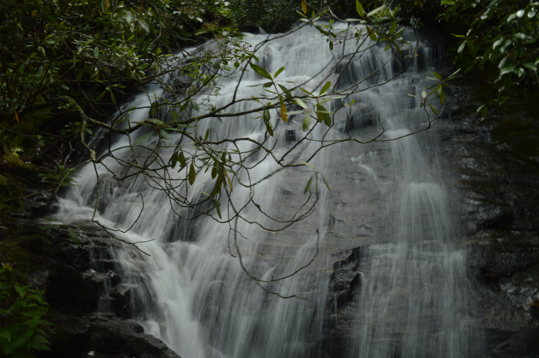
High Shoals Creek is home to two of Georgia's most popular waterfalls: High Shoals Falls and Blue Hole Falls. Very few people who hike to those waterfalls know that the same watershed is home to a remote waterfall no less impressive. Rogers Branch Falls is a tiered 80-foot waterfall on a tributary of High Shoals Creek, with additional small waterfalls above and below the main drop. Even though local residents are aware of the waterfall as evidenced by the well-used path to it, it is not publicized well at all and clearly off the radar for most hikers and waterfall hunters. The routes to the base of Rogers Branch Falls are not quite for everyone due to their steepness, but those who reach the viewing area at the base will be rewarded by a breathtaking sight. This hike occurred on Saturday, July 1st, 2017. My plan was to hike out and back to the base of Rogers Branch Falls from a popular camping area off Indian Grave Gap Road. 

Summary

R/T Length of Trail: 0.3 Miles 
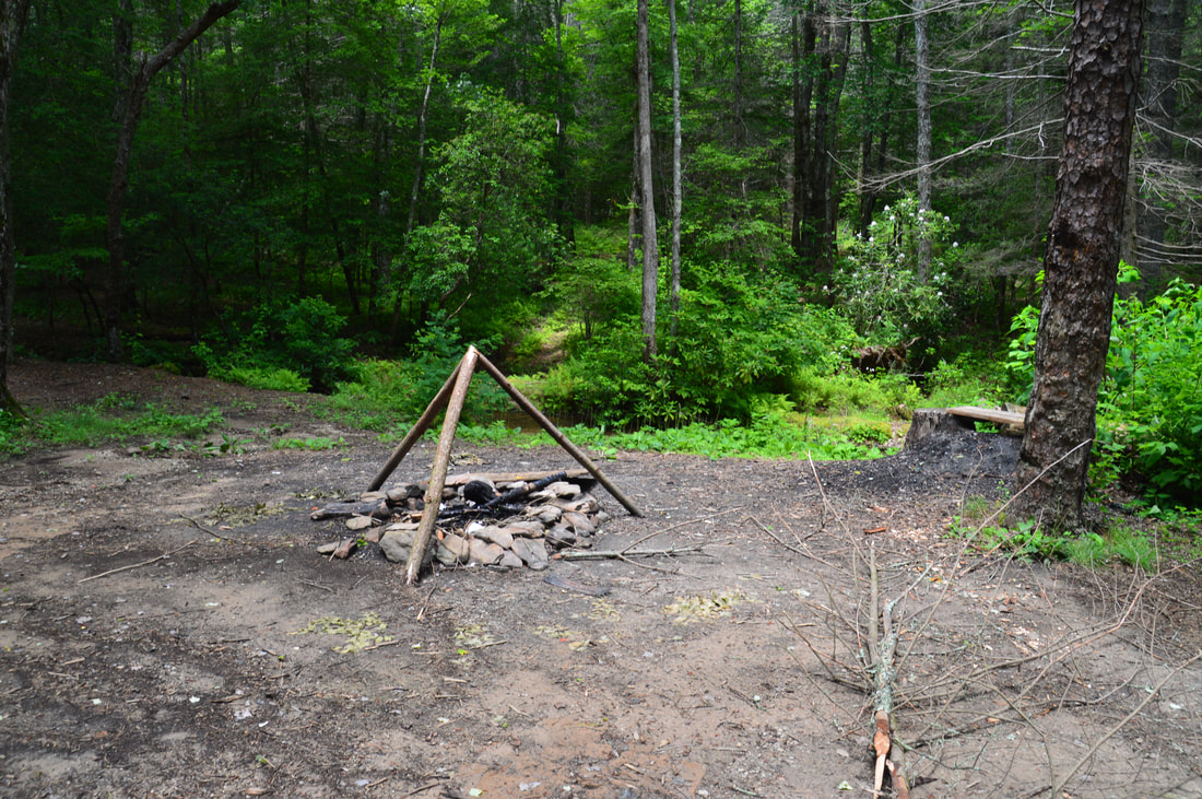
Duration of Hike: 1:30 (time for photography is included) 
Type of Hike: Out and Back 
Difficulty Rating: 4 out of 10 
Total Elevation Gain: 177 Feet
Pros: Nearly-guaranteed solitude at the base of Rogers Branch Falls 
Cons: Some lack of parking space near the campsite at the beginning of the hike to the falls; Rogers Branch is a small stream so the waterfall may not look great during drier periods; the trail to the base of the falls is very steep
Points of Interest: Rogers Branch Falls - 8 stars (considerably lower during dry periods) 
Trail Blaze Colors: None, not an official trail 
Best Seasons to Hike: Winter; Spring 
Fees: None 
Beginning Point: Campsite near Tray Mountain Road 
Directions from Helen, GA: From the intersection of GA 75 and GA 356 north of downtown Helen, follow GA 75 North for 10.2 miles. Then, turn very acutely right onto Indian Grave Gap Road. Continue on the unpaved road that turns into Forest Service Road 283 for a total of 2.2 miles to a slightly overgrown but obvious drivable side road on the left. Turn onto this side road and follow it for 0.1 miles to a fork just above the road's end at a campsite. The two forks of the road reconnect at the campsite, but the best parking spots are around the fork. if absolutely all of the pullouts are utilized, I would say that a half-dozen cars can fit in. Parking in the campsite itself is not recommended, because it appears to be a popular site. Note: Along the way on Indian Grave Gap Road, you will pass through a vehicle ford of the Hiwassee River. This is a wide and fairly shallow ford, but depending on the water level, some passenger vehicles may not be able to make it. If you have concerns about your vehicle passing through, you will have to take the alternate more time-consuming route along Tray Mountain Road (FS Road 79), which begins much further south off Highway 75. 

Map

Picture
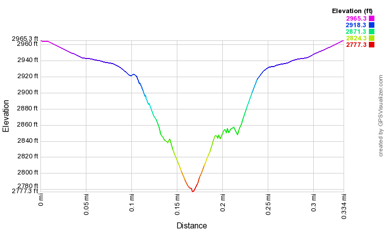
Click here to download a track of this hike. 

Details

Rogers Branch Falls is a waterfall at the south end of Swallow Creek Wildlife Management Area that I first identified on Google Earth satellite imagery. Due to how impressive it looked on satellite, I made plans to check out the site, and before my hike, I received confirmation of the waterfall's existence from a few friends. When I got to the base of Rogers Branch Falls, I was amazed that such a tall and photogenic waterfall could be largely unknown. Even though there clearly are signs of numerous visits to the falls, I did not find any online references to the falls prior to my discovery of it on satellite and my friends' visits to it. 

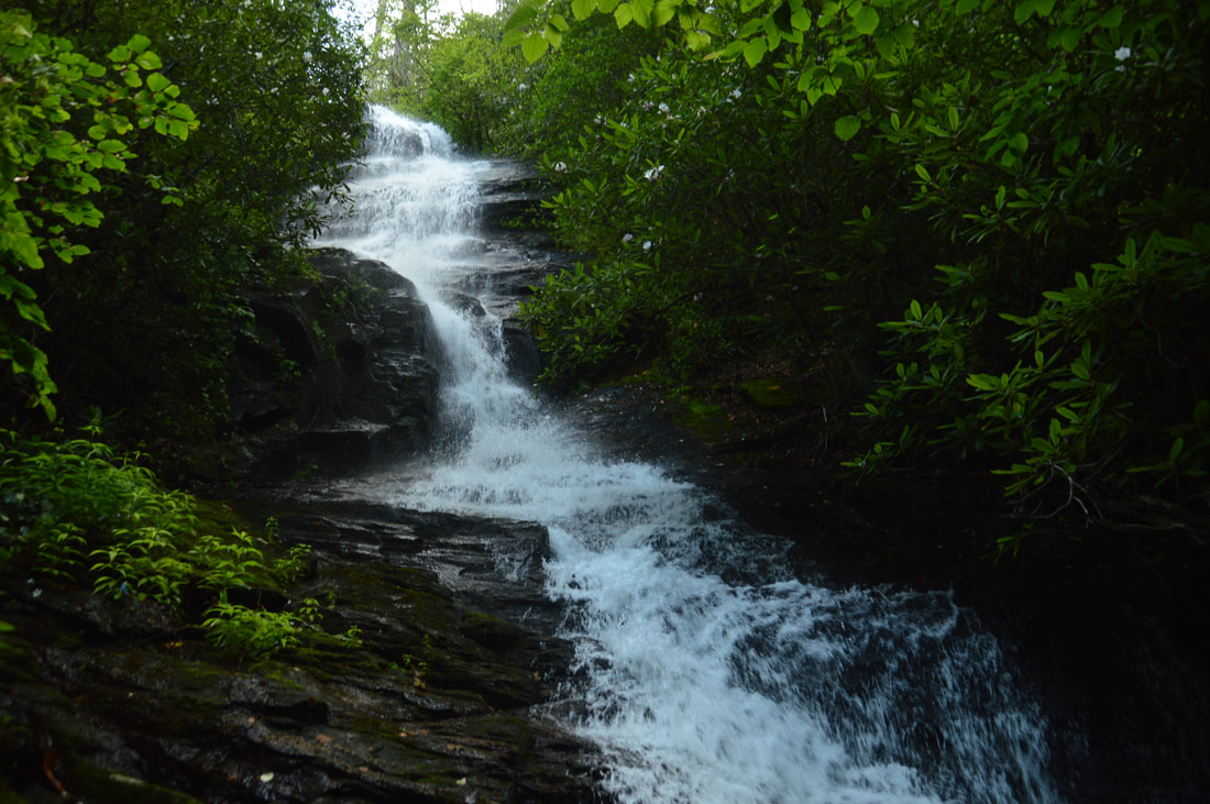
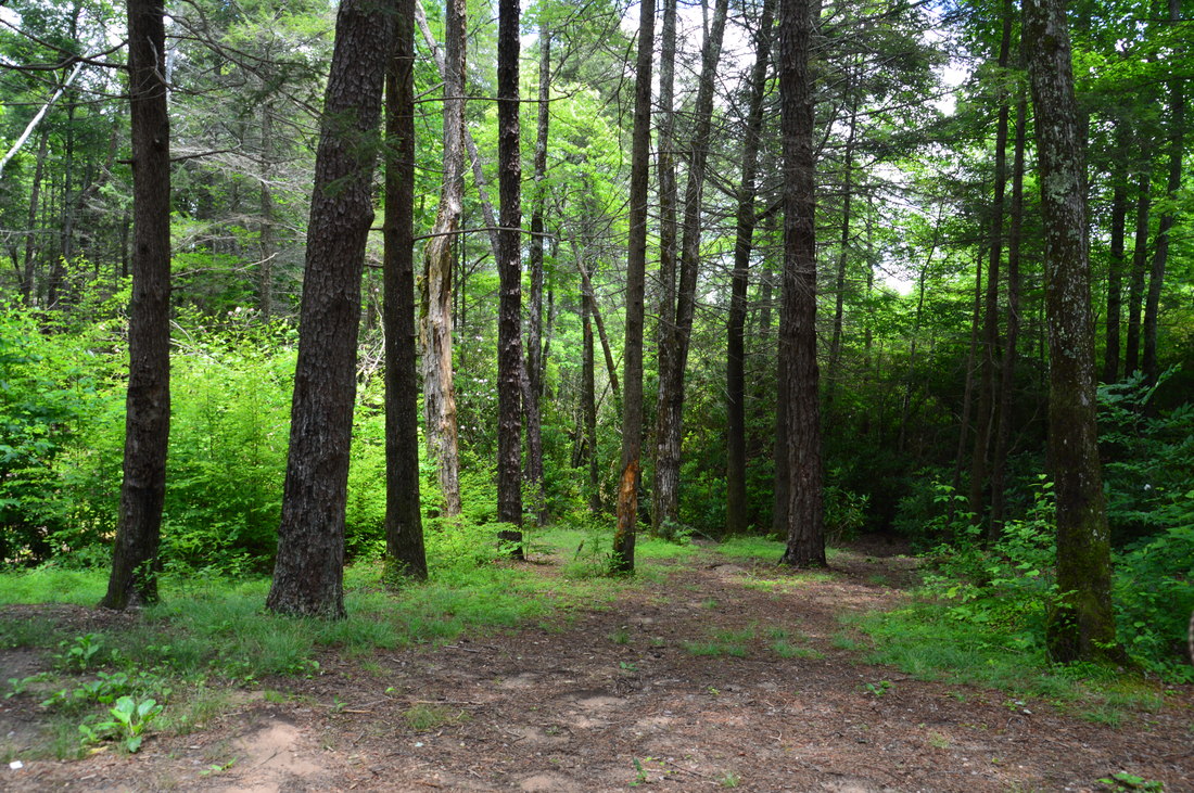
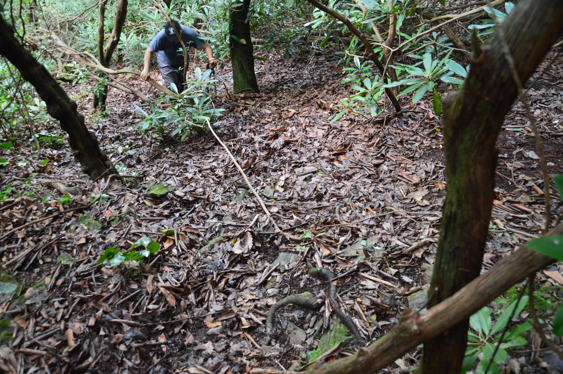
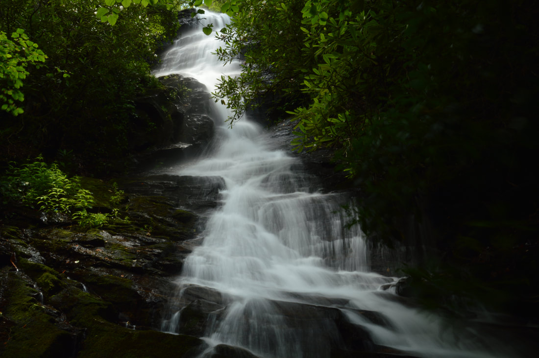
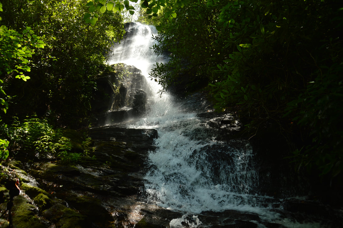
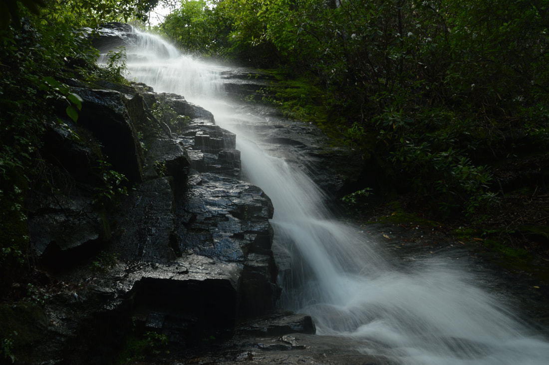
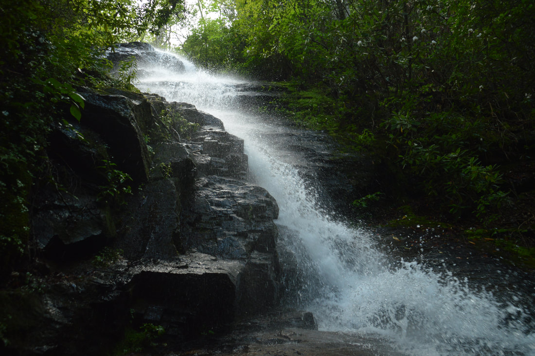
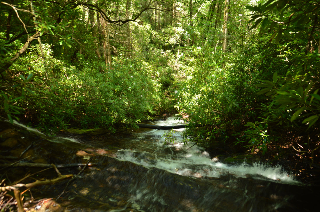
Begin the hike to Rogers Branch Falls at the far end of the large campsite near the parking area. A path to the falls heads down to Rogers Branch, hopping across the main stream and a small drainage channel. The path continues downstream along the left-hand side of Rogers Branch. About 400 feet from the parking, the path reaches the top of the 20-foot upper cascade above Rogers Branch Falls. The path continues to the base of the falls along the same side of the creek, descending right alongside the falls, but the path is extremely steep, difficult, and potentially life-threatening. I do not recommend using this path at all, because there are a couple of spots where it is easy to slip right out into the middle of the waterfall and a fall there is likely to be fatal. A much safer alternative that is not immediately obvious is to cross Rogers Branch above the upper cascade and follow a less steep path on the right side of the creek. Normally, the crossing will be safe and usually dry, but if the water is up, do not attempt it as 120 feet of falling water lie only a few yards downstream. When I went to the falls, I climbed down the insane trail on the left side and returned back up along the path on the right side, and I can tell you that the path on the right side is much easier and safer without a shade of doubt. The map above shows the path on the right side only. 

Thus, cross the creek, and begin hiking down alongside it along the route of least resistance - that should be easy to see. The path shortly passes the base of the upper cascade. It is beautiful - but make sure to stay away from the creekbed and the slippery rocks surrounding it when viewing the cascade, as the top of the main falls is only a few feet downstream. The path continues past a small rock outcrop, bears right slightly away from the falls, and descends down a steep but open slope. This slope isn't as steep as the other side of the creek, but you still have to be careful going down, and for some folks, a rope can be useful on the way back (although my friends and I made it without a rope just fine and many other people will too). The path eventually veers left, narrows, and ends at the base of Rogers Branch Falls at 0.15 miles. 

When there is enough water in this small stream, Rogers Branch Falls is a breathtaking sight! The 80-foot waterfall begins with a series of cascades and free-falls down the steepest part of the cliff. In particular, the last and largest free-fall part is stunning as the creek sends off spray in different directions that shimmers profusely under sunlight. The lower half of the waterfall consists of a very photogenic stairstep cascade that runs all the way down to the viewing area and continues even more steeply farther down for another 20+ feet. If the upper and lower cascades are included, that makes the full height of Rogers Branch Falls a whopping 120+ feet! As with many other waterfalls, pictures of Rogers Branch Falls taken on cloudy days will have the highest quality, but there's a bit of a catch. If you can get to the waterfall at the just-right time of day - mid-afternoon on the summer day that I visited - the sun is going to give off sun rays that hit the upper part of the waterfall and the spray produced by it, creating a gorgeous unique scene. My pictures didn't do justice to the beauty of the sun rays. 

From the base of the falls, return back to the parking area along the same way, concluding the hike at just 0.3 miles. Even though this hike is extremely short, it still isn't a hike for beginners. The path climbs up nearly 200 feet in 0.15 miles (with the bulk of the climb being even shorter) on the way back to the parking! Keep that in mind when you set out to see this spectacular waterfall. 

Mileage

0.0 - Rogers Branch Parking 
0.15 - Rogers Branch Falls 
0.3 - Rogers Branch Parking

Variations

None

Bonus Stops

The trailhead for Blue Hole Falls and High Shoals Falls is also on Indian Grave Gap Road, just north of the Rogers Branch Falls parking. The hike to those waterfalls would make for a nice combination with Rogers Branch. 

Pictures

Videos

2 Comments
Alex
9/19/2018 10:57:27 am

As of August 2018, these falls are unrecognizable from these pictures. Very difficult bushwhack down to the base and you have to climb onto what seems to be a landslide blowdown, likely occuring in the fall of 2017. You can barely see any of the falls through the fallen shrubs and trees. Thank you for the detailed trail report! I just wanted to update.

Reply
Zhili Zhan
6/13/2020 10:35:14 pm

Yes. Alex. we went there today. I can confirm what you found out in 2018. We managed to get out of the Rhodo tangle to the base of the falls. But lots of deadfalls are in the middle of the creek and the falls are totally unrecognizable from the pictures and videos Mark posted.

Reply


Leave a Reply.

    About Me

    Mark Oleg Ozboyd
    I'm an avid outdoor explorer and a hobbyist landscape photographer. I'm 21 years old and have been hiking since 2011. Originally based out of Atlanta, Georgia, I started out by occasionally hiking short trails throughout well-known Georgia State Parks. During 2012 and 2013, I began to expand my trips into adjacent states, as well as into the wilder National Forest areas rather than just State Parks. Throughout the years that followed, as I slowly ran out of popular hiking trails in my area, I began to search for and hike in more seldom-visited areas. Today, you can find me out in the woods every weekend, whether it's on an official trail or bushwhacking through cross-country terrain without any paths. I now attend Washington & Lee University and am exploring Virginia and West Virginia. My other hobbies include chess, science, old music, and meteorology. I have 3 years of amateur weather forecasting experience, having studied a lot of meteorology basics over the years. I am also a student at European School of Music where I learned that music and nature have a lot in common. Listening to good music inspires me to capture nature's beauty on the camera in different aspects that also make me recall many beautiful music pieces that I've heard.​


    Dear readers: I have invested a tremendous amount of time and effort in this website and the Georgia Waterfalls Database the past five years. All of the work that has gone in keeping these websites updated with my latest trip reports has almost been like a full-time job. This has not allowed me to pick up a paid job to save up money for college, and therefore, I I've had to take out loans. If you find the information on this website interesting, helpful, or time-saving, you can say "thanks" and help me out by clicking the button above and making a contribution. I will be very grateful for any amount of support you give, as all of it will apply toward my college tuition. Thank you! 

    Enter your email address to subscribe for trail reports:

    Delivered by FeedBurner


    Picture
    Coming in 2022-2023?

    Other Hiking Websites

    DWHike's Adventures
    Florida's Natural Wonders
    Florida Trailblazer
    Meanderthals
    Mountain Images
    by Bernie Boyer

    North Carolina Waterfalls with
    ​Kevin Adams
    Take-a-Hike!
    Tennessee Landforms
    Waterfall Page
    Waterfall Adventurer
    Zach's Mild Adventures

    Miles Hiked

    Year 1: 540.0 Miles
    Year 2: 552.3 Miles
    ​Year 3: 518.4 Miles
    Year 4: 482.4 Miles
    Year 5: 259.9 Miles

    Archives

    March 2021
    February 2021
    January 2021
    November 2019
    October 2019
    September 2019
    August 2019
    July 2019
    June 2019
    February 2019
    January 2019
    December 2018
    November 2018
    October 2018
    August 2018
    July 2018
    June 2018
    May 2018
    April 2018
    March 2018
    February 2018
    January 2018
    December 2017
    November 2017
    October 2017
    September 2017
    August 2017
    July 2017
    June 2017
    May 2017
    April 2017
    March 2017
    February 2017
    January 2017
    December 2016
    November 2016
    October 2016
    September 2016
    August 2016
    June 2016
    May 2016
    April 2016
    March 2016
    January 2016
    December 2015
    November 2015
    October 2015
    September 2015
    August 2015
    July 2015
    June 2015
    May 2015
    April 2015
    March 2015
    February 2015
    January 2015
    December 2014
    November 2014
    October 2014
    September 2014
    August 2014
    July 2014
    June 2014
    May 2014
    April 2014
    March 2014
    February 2014

    Categories

    All
    Adel
    Adirondack Park
    Alabama
    Alfred A. Ring Park
    Allegheny Trail
    Amicalola Falls State Park
    Anniston Area
    Apalachicola Bluffs And Ravines Preserve
    Apalachicola National Forest
    Apalachicola/Port St. Joe Area
    Apopka
    Appalachian Trail
    Appling
    Art Loeb Trail
    Aska Trail System
    Bakersville
    Balm-Boyette Scrub Preserve
    Balsam Lake Recreation Area
    Bankhead National Forest
    Bartow County Parks
    Bartram Trail
    Basinger
    Beersheba Springs
    Benton
    Benton Mackaye Trail
    Berry College Trail System
    Best Hike
    Big South Fork National Recreation Area
    Black Bear Wilderness
    Black Rock Mountain State Park
    Blairsville
    Blakely
    Blood Mountain Wilderness
    Blowing Rock
    Blue Ridge
    Blue Ridge Parkway
    Boone
    Bradenton
    Bradenton Beach
    Brasstown Bald
    Brasstown Wilderness
    Brevard
    Bryson City
    Buchanan
    Bucks Pocket State Park
    Bulow Creek State Park
    Bulow Plantation Ruins State Park
    Caesars Head State Park
    Caladesi Island State Park
    Calhoun
    Camel's Hump State Park
    Cashiers
    Caspersen Beach Park
    Catfish Creek State Park
    Caves
    CC Putnam State Forest
    Cedar Point Environmental Park
    Chatsworth
    Chattahoochee National Forest
    Chattanooga
    Chattanooga Valley
    Chattooga National Wild And Scenic River
    Cheaha Wilderness
    Cherohala Skyway
    Cherokee
    Cherokee National Forest
    Chiefland Area
    Chillhowee Recreation Area
    Chipley
    Chunky Gal Trail
    Circle B Bar Reserve
    Citico Creek Wilderness
    Citrus Wildlife Management Area
    Clarkesville
    Clayton
    Cleevland
    Cleveland
    Cloudland Canyon State Park
    Cohutta Wilderness
    Collier-Seminole State Park
    Cordele
    Cornelia
    Covington
    Crestview Area
    Crew-land-and-water-trust
    Cullowhee
    Cumberland Trail
    Dahlonega
    Dalton
    Dawson Forest Wildlife Management Area
    Dawsonville
    Dayton
    De Soto National Memorial
    DeSoto State Park
    Dillard
    Double Springs
    Ducktown
    Duncan Ridge Trail
    Dunlap
    Eagle's Rest Park
    Eastpoint
    Econfina Creek Wildife Management Area
    Eglin Air Force Base
    Elizabethton
    Elkins
    Elk Knob Game Lands
    Elk Park
    Ellicott Rock Wilderness
    Ellijay
    Emerson Point Preserve
    Englewood Area
    Enota Retreat
    Erwin
    Falling Waters State Park
    Fayetteville
    Fires Creek Recreation Area
    Fire Tower
    Flint River
    Florence Area
    Florida
    Florida Caverns State Park
    Florida Trail
    Foothills Trail
    Fort Mountain State Park
    Fort Myers Area
    Fort Payne
    Fort Payne Area
    Fort Yargo State Park
    Franklin
    Franklin Delano Roosevelt State Park
    Franklin-Marion State Forest
    Frozen Head State Park
    Gainesville
    Gainesville Area
    Gatlinburg
    George Washington National Forest
    Georgia
    Georgia Veterans Memorial State Park
    Glasgow
    Gorges State Park
    Grandfather Mountain State Park
    Great Smoky Mountains National Park
    Greeneville
    Green River Game Lands
    Gruetli-Laager
    Grundy Forest State Natural Area
    GTM Reserve
    Guana River Wildlife Management Area
    Hayesville
    Helen
    Hiawassee
    High Falls State Park
    Highlands
    Highlands Scenic Highway
    Hillsborough River State Park
    Hinson Conservation & Recreation Area
    Historic Sites
    Honeymoon Island State Park
    Hot Springs
    Huntington
    Inverness Area
    Jackson
    Jasper
    Jefferson National Forest
    Joan M. Durante Park
    Jonathan Dickinson State Park
    Jones Gap State Park
    Joyce Kilmer Slickrock Wilderness
    Joyce Kilmer - Slickrock Wilderness
    Juniper Prairie Wilderness
    Kelly Park
    Keown Falls Recreation Area
    Kolomoki Mounds State Park
    LaFayette
    Lake City Area
    Lake George Wild Forest
    Lake June-in-Winter State Park
    Lakeland Area
    Lake Placid
    Lake Russell Wildlife Management Area
    Lake Wales Ridge State Forest
    Laurel Fork North Wilderness
    Leffis Key Preserve
    Leon Sinks Geological Area
    Lexington
    Lineville
    Linville
    Linville Gorge Wilderness
    Lithia Springs
    Little Frog Wilderness
    Little Manatee River State Park
    Little River Canyon National Preserve
    Longboat Key
    Long Trail
    Lookout Mountain
    Lookout Mountain Battlefield
    Lovingston
    Lula Lake Land Trust
    Lumpkin
    Maggie Valley
    Manatee Springs State Park
    Marianna Area
    Mark Trail Wilderness
    Marlinton
    Mccaysville
    McMinville
    Mentone
    Middlesex
    Mistletoe State Park
    Monongahela National Forest
    Montreat
    Mountain Bridge Wilderness Area
    Mountain City
    Mountains To Sea Trail
    Mountains-to-Sea Trail
    Mount Rogers National Recreation Area
    Myakka River State Park
    Myron B. Hodge City Park
    Nantahala National Forest
    Naples
    Naples Area
    Natural Bridge State Park
    Neal Preserve
    New Castle
    Newport
    New River Gorge National Park
    New York
    North Carolina
    Ocala Area
    Ocala National Forest
    Ocean-to-Lake Trail
    Oconee State Park
    Oconee Station Historic Site
    Okaloacoochee Slough State Forest
    Oldsmar
    Oneida
    Orlando Area
    Ormond Beach
    Oscar Scherer State Park
    Oxford
    Palatka
    Palmetto Trail
    Panama City Area
    Panthertown Valley
    Parrish
    Paynes Creek Historic State Park
    Peaks Of Otter Recreation Area
    Pigeon Crockford Mountain Wildlife Management Area
    Pigeon-Crockford Mountain Wildlife Management Area
    Pigeon-Crockford Wildlife Management Area
    Pine Mountain
    Pinhoti Trail
    Pinnacle Park
    Pisgah Civitan Park
    Pisgah National Forest
    Pittman Center
    Pond Mountain Wilderness
    Ponds/Lakes
    Prentice Cooper State Forest
    Providence Canyon State Park
    Pumpkintown
    Quick Point Nature Preserve
    Raven Cliffs Wilderness
    Reed Bingham State Park
    Reliance
    Rice Creek Conservation Area
    Riverview Pointe Preserve
    Robbinsville
    Robinson Preserve
    Rock Creek Gorge Scenic Area
    Rock Island State Park
    Rome
    Rosman
    Sale Creek
    Salem
    Salt Springs
    Saluda
    Santa Rosa Beach
    Sarasota
    Sarasota Area
    Savage Gulf State Natural Area
    Scenic Views
    Scottsboro Area
    Sebring Area
    Sewanee
    Sheltowee Trace Trail
    Shining Rock Wilderness
    Signal Mountain
    Sipsey Wilderness
    Sky Valley
    Smithgall Woods State Park
    Snowbird Backcountry Area
    Soddy Daisy
    Soddy-Daisy
    Sopchoppy
    South Carolina
    South Cumberland State Park
    Southeastern Cave Conservancy
    Southern Nantahala Wilderness
    Sparta
    Sprewell Bluff Park
    Spring City
    Spring Hill
    Springs
    Spruce Pine
    Standing Indian Backcountry Area
    St. Augustine
    St. George Island State Park
    St. Joseph Bay State Buffer Preserve
    St. Marks Area
    St. Marks National Wildlife Refuge
    Stone Mountain
    Stone Mountain Park
    Suches
    Sumatra
    Sumter National Forest
    Suwannee River
    Swallow Creek Wildlife Management Area
    Sweetwater Creek State Park
    Sylva
    Talladega National Forest
    Tallahassee Area
    Tallulah Falls
    Tallulah Gorge State Park
    Tampa Bay Area
    Tate City
    Tate's Hell State Forest
    Tea Creek Wildlife Management Area
    Tellico Plains
    Tennessee
    Thomaston
    Toccoa
    Topsail Hill State Park
    Torreya State Park
    Townsend
    Tracy City
    Tray Mountain Wilderness
    Trenton
    Triple Creek Preserve
    Troutdale
    Unaka Mountain Wilderness
    Upper Tampa Bay County Park
    Venice
    Vermont
    Virgin Falls State Natural Area
    Virginia
    Virginia Outdoors Foundation
    Vogel State Park
    Wakulla Springs State Park
    Waleska
    Walhalla
    Wartburg
    Water Features
    Waynesville
    Weedon Island Preserve
    Weeki Wachee Preserve
    Wekiwa Springs State Park
    West Palm Beach Area
    West Virginia
    Whitehall
    White Springs
    Winder
    Withlacoochee State Forest
    Young Harris

    RSS Feed

TRAIL REPORTS

Hikes in Alabama
​Hikes in Florida
Hikes in Georgia
Hikes in North Carolina
Hikes in South Carolina
Hikes in Tennessee
Hikes in Virginia

Hiking Resources

Alabama Resources
​
Florida Resources
Georgia Resources
North Carolina Resources
​South Carolina Resources
​
Tennessee Resources

Other

Contact
Map of Hikes
Alphabetical List of Hikes
Southeast Nature Society
© COPYRIGHT 2014-2018
​ALL RIGHTS RESERVED.
Important: I disclaim any responsibility for any damage or personal injury that may occur as a result of the activities and information found on this website. All outdoor activities, especially off-trail hiking, are done at your own risk. Never hike or head into that area that may be above your fitness or experience level.
  • Home
  • Trail Reports
    • Best Hikes
    • Hikes with Scenic Views
    • Hikes with Water Features
    • Alabama
    • Georgia
    • Florida
    • North Carolina
    • South Carolina
    • Tennessee
    • Vermont
    • Virginia
  • Map
  • Hike List
  • Testimonials
  • Resources
  • Contact Us
  • Southeast Nature Society
    • Our Team
  • Georgia Waterfalls Database