Great Smoky Mountains National Park: Gregory Bald via Gregory Ridge Trail, Townsend, Tennessee6/10/2014 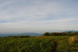 The Great Smoky Mountains National Park in East Tennessee/West North Carolina is an incredible diversity of wildlife, not to speak of the incredible hiking opportunities. I've been to the Smokies a handful of times, and one of my favorite experiences was Chimney Tops on Newfound Gap Road. However, this is only the second time I've been to the Smokies before I started the blog where I am writing at. Gregory Bald is most famous for the flame azalea that blooms in early to mid June on its summit. In addition, Gregory Bald has a 2 acre grassy area at the top (hence the name "bald"), and the views are pretty much 360 degrees. My main problem on this hike was summer haze limiting the views somewhat, but it was still beautiful. This hike occurred on Saturday, June 7th, 2014. My plan was to hike the Gregory Ridge Trail from the end of Forge Creek Road to Rich Gap. Rich Gap is where the Appalachian Trail used to pass through before it was rerouted. From Rich Gap, my plan was to turn right onto the Gregory Bald Trail and follow it to the summit of Gregory Bald. I would return the same way to the trailhead. R/T Length of Hike: 11 Miles Duration of Hike: 6 Hours Type of Hike: Out and back Hike Rating: 7 out of 10; Some rocky areas although mainly dirt path, footbridges and one rock hop, long, tiring ascent Beginning Point: End of Forge Creek Road a couple miles south of Cades Cove Directions: From Townsend, TN: Follow TN State Route 73 south for 2.3 miles until the Townsend Wye after you enter Great Smoky Mountains National Park. At the Townsend Wye, turn right onto Laurel Creek Road. Follow Laurel Creek for 7.5 miles until you reach the start of the one way Cades Cove Loop Road. Follow the Loop Road for 5.5 miles until the Cades Cove Visitor Center, and then keep forward, bearing right onto the gravel Forge Creek Road. Follow the road for 2.2 miles until it terminates at the cul-de-sac and trailhead for Gregory Ridge Trail. You can park in the few sparking spaces or along the cul-de-sac. Be aware that the parking lot fills up quickly during peak azalea bloom. It was time for a new trip to the Smokies! May/June are the times when many of the spring wildflower blooms pick up, so I quickly found a trail that would work for me: Gregory Ridge Trail to Gregory Bald. There's two ways to access Gregory Bald. The first way is the one listed above via Gregory Ridge. There is a shorter way (about 9 miles roundtrip) if you park somewhere down Parson Branch Road, but I had no intention in parking there since it is one way and would lead me out way down to US 129 southeast of Maryville. I have to warn you, if you do this trail, get out before dark! Every single road in Cades Cove has a gate that "closes at will". When I finished the hike around 10:30 PM in the evening (about an hour after dark), I was lucky to find the gate to Forge Creek open, but the gate to the end of Cades Cove Loop Road was locked. There's a payphone at the Cades Cove Ranger Station that you can use, and I was lucky that the ranger didn't leave the station yet. Honestly, I do not know what I would have done, if the gate to Forge Creek Road was closed. Walked 5 miles to the ranger station, and then back another 5 miles to my car? That makes for a nice desert, having already 11 miles on my legs. Anyway, enough with the worries. Just make sure you get out before dark, or you may be in trouble. I am pretty sure they just forgot to close the Forge Creek Road gate. The trailhead at the end of Forge Creek Road is at a cul-de-sac, which has space for maybe a dozen cars. However, I think you can park along the road as well. The trail starts at the far end of the cul-de-sac and immediately starts climbing. However, at 0.1 miles, it levels out and even starts descending. I think this was the only measurably long descent on the entire trail (obviously without counting the way back). At 0.3 miles, the trail reached Forge Creek, and crossed a footbridge. After this, the trail continued through a flat area, although it started ascending after 0.6 miles. The ascent was pretty gradual though. There were numerous small stream crossings. The steepest part of this section of the trail was somewhere near 1.3 miles I think. There was a very brief downhill at one point, but generally, it was either flat or uphill. This part of the trail also featured a large old-growth forest. At 1.7 miles, the trail crossed another footbridge over Forge Creek. At 1.8 miles, the trail crossed Forge Creek yet again, but without a footbridge. The rock hop turned out successful though, and you can probably cross the creek always, except in very high water levels. Right after this, a short but steep ascent brought me to Campsite #12 at 1.9 miles. then, the trail started a long ascent out of the Forge Creek Valley. Keep in mind that there won't be anymore measurable water along the trail. The trail ascends steadily, but not very steeply. There was one more crossing of a small brook, and the ascent continued. At 2.2 miles, the trail reached a clearing with large boulders. Here there was a nice view to the west. This was also where the trail reached Gregory Ridge. From now on, the trail would follow Gregory Ridge all the way to the Gregory Bald Trail. Generally, there isn't much to describe for the next couple of miles of the trail, other than it is ascending, ascending, and ascending. Somewhere around the 3 mile mark, I saw two wild turkeys cross the trail, although by the time I reached them, they were too far away for me to take a picture. There was another wild turkey closer to the 4 mile mark, but again, to far off the trail to be pictured. The ascent wasn't really tiring, because it wasn't steep, but it was beginning to take a toll after 4 miles. The steepest part seemed to be around 4.5 miles, before the trail leveled out at 4.8 miles, and reached Rich Gap at 4.9 miles. Rich Gap is a big trail junction. The Gregory Ridge Trail ends here. To the left, the Gregory Bald Trail reaches the Long Hungry Ridge trail in 0.1 miles, and the Appalachian Trail in 2 miles. To the right, the Gregory Bald Trail ascends to Gregory Bald in 0.6 miles, reaches the Wolf Ridge Trail in another 0.6 miles, and ends at Parson Branch Road in 4.1 miles from the Wolf Ridge Trail junction. Meanwhile, an unmaintained trail goes forward to a spring, which may potentially have some water. My goal of this hike was to get to Gregory Bald, so I turned right. onto the Gregory Bald Trail. At first the ascent was steep, but after 0.2 miles from the junction, it leveled off, and there was even a brief descent. At 0.4 miles, the ascent started again, and it was final. At 0.5 miles, the trail exited the forest onto the large summit of Gregory Bald. It was like entering the top of the world. The trail passed through an incredible growth of flame azalea bushes. Far from all were blooming, but there enough for pictures. the trail kept gradually ascending, and the surrounding mountains came in view. 0.6 miles from the junction, the trail reached the the rounded summit of Gregory Bald. It was incredible. Views were in all directions, and the camera was snapping photos at will. There was also a National Geographic Survey marker here. A little down the trail, there was a sign with information about balds. If you come onto the bald like I did, then here's what you see. In front of you (to your west) is the Calderwood Lake area. To your left (south) is the NC side of the Smokies, Shuckstack Mountain, and Fontana Lake. Behind you (to your east) is the main ridge of the Smokies that follows the TN/NC state line. And to your right (north) is Cades Cove and the Townsend area. The bald is definitely a place to linger... On my way back down the Gregory Bald Trail, there was a lot of racket just to the left. I think it was a wild hog that got REALLY scared by my presence, but it could have been a bear too. I never saw the source of the racket. Later, further down the Gregory Ridge Trail, I saw 3 wild hogs. It was a mother and two juveniles. Unfortunately, it was already twilight and they were too far away for me to picture them. The rest of the hike was pretty uneventful. Overall, this is a long and somewhat hard hike. Never too steep, but tiring. However, the reward at the end overthrows everything. Below are my pictures and a video!
2 Comments
Nice write-up, Mark. I did Gregory Ridge a couple of years ago in October, and Gregory Bald last year in June. Despite the longer mileage, I prefer the former just because of trailhead access. Parson's Branch Road isn't very non-SUV friendly. Thanks for taking the time to write this up. Thank you! I am pretty good at handling any types of roads, but the main reason why I started from this trailhead (even though it's a longer trail) is because if I parked on Parson Branch Road, I would have to drive out onto the Dragon US 129 area, which means I would then have to drive 50 miles back to Gatlinburg. Leave a Reply. |
About MeMark Oleg Ozboyd Dear readers: I have invested a tremendous amount of time and effort in this website and the Georgia Waterfalls Database the past five years. All of the work that has gone in keeping these websites updated with my latest trip reports has almost been like a full-time job. This has not allowed me to pick up a paid job to save up money for college, and therefore, I I've had to take out loans. If you find the information on this website interesting, helpful, or time-saving, you can say "thanks" and help me out by clicking the button above and making a contribution. I will be very grateful for any amount of support you give, as all of it will apply toward my college tuition. Thank you!

Coming in 2022-2023?
Other Hiking WebsitesMiles HikedYear 1: 540.0 Miles
Year 2: 552.3 Miles Year 3: 518.4 Miles Year 4: 482.4 Miles Year 5: 259.9 Miles Archives
March 2021
Categories
All
|
 RSS Feed