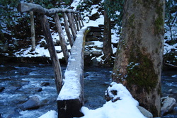
 On the southern side of the Great Smoky Mountains National Park, flows the Oconaluftee River. In the foothills of the Smokies, lies Smokemont Campground. There are many hiking opportunities in the campground area, and they become useful, when Newfound Gap Road closes during snow, leaving the Campground as the only option for hiking. The Smokemont Loop Trail, a combination of the Bradley Fork Trail, Smokemont Trail, and Benton Mackaye Trail. The trail follows Bradley Fork, which flows into the Oconaluftee, before climbing a high rudge, named Richland Mountain. I hiked this trail on Saturday, February 15th, 2014, after a moderate snowstorm. My plan was to start at the old church and hike the Smokemont Loop clockwise. SummaryR/T Length of Trail: 7 Miles Duration of Hike: 3:30 Type of Hike: Loop Difficulty Rating: 3 out of 10 Pros: Mostly wide, easy-to-follow trails Cons: Some horse traffic on Bradley Fork Trail Points of Interest: Smokemont Baptist Church Trail Blaze Color(s): None Best Season(s) to Hike: Winter Fees: None Beginning Point: Smokemont Campground Directions: From Cherokee, NC: Drive 6.7 miles north on US Route 441 through Cherokee and portions of the Great Smoky Mountains National Park, as well as past the Oconaluftee Visitor Center, until you see the sign showing right turn for Smokemont. Take a right at the sign, cross the bridge, and park in either of the two designated areas at the T-shaped intersection. DetailsIt is a long drive from the Atlanta metro to the Great Smoky Mountains National Park, and yet I do it pretty often. It was a beautiful sunny morning as I set out for the park, hearing about a few inches of snow on the ground from last night's snowstorm, with higher amounts in the closed sections of the park. I drove through the historic Indian town of Cherokee and arrived at the Smokemont Campground after a 3 and a half hours of driving. There are two parking lots for the trail, but I was alone on the trail. There was some light snow on the ground too. At the trailhead, there is a trail junction. If you go straight up the hill, you will reach the Smokemont Baptist Church If you take a right, the trail will take you to the Tow String and Horse Stables. The left trail is the start of the Smokemont Loop Trail, and there is a sign "Bradley Fork 1.0". I took that trail. It starts as a very gradual ascending trend, but flattens out quickly. During the first mile, there will still be some ups and downs, but overall, it is pretty flat. In 1 mile from the beginning, you reach an intersection. If you take a right, this will take you back to the Tow String in a matter of 2.2 miles. I did not have that trail in mind, so I just kept left on the main trail, and in a minute, you will come to another intersection. Here, if you take a left, you will come to the Campground in 0.2 miles. If you just want a leg-stretcher, this part of the trail makes an easy loop, being only 1.7 miles in round trip length (an additional 0.5 miles on the road). However, for the purpose of this trail description, as well as my plan for a longer hike, I took a right, at the sign where it says "Chasteen Creek 1.0 miles". This part of the trail is very easy. It is flat, and follows Bradley Fork. The creek is beautiful, and this part of the trail I enjoyed very much, with the creek being surrounded by a coating of fresh snow. In about a mile, I reached another intersection. Luckily, all of these were marked. If you take a right on this intersection, you would go onto the Chasteen Creek Trail, which goes along with the Benton Mackaye Trail, up to the top of Hughes Ridge. This is a hike I definitely plan to do another day, but for now, my plans were to continue following the Bradley Fork Trail and Smokemont Loop Trail along Bradley Fork. In another 0.5 miles of following the creek, I reached the final intersection of the trail, where also the longest section would start. Forward, the Bradley Fork Trail continued towards the Cabin Flats Trail, following Bradley Fork, while to the left, went the Smokemont Loop Trail. From this point, there was 3.9 miles to the campground. The trail immediately crossed Bradley Fork on a long narrow footbridge. It was a little bit icy, so I had to be very careful crossing it. I took a few pictures of the creek, and then, after crossing a smaller stream on another footbridge, the long climb started. Approximately the next 2 miles would be a climb up Richland Mountain. At first it was easy, as it was curving around the mountainside, not producing any big problems. It was just moderate. However, eventually it rounded the mountainside, and reached a short ridge-line section. From this point, it became much steeper. The trail, without any switchbacks, kept following the side of the mountain and climbing steeper and steeper, with barely any places to catch breath. There were a couple decent overlooks, although nothing extraordinarily beautiful. Finally, after one last steep ascent, I reached the highest point of the trail. Although it was not the summit, it was pretty close. From here, it was all downhill. The trail winded down the other side of the mountain, and the slope was pretty steep, and I was kind of being carried down the snow covered trail. There was one creek, which was easily crossed, and before I knew it, I was at the bottom. However, I was not at the campground yet, and if you do not have a compass, this intersection might be a little tricky. The only sign there was, was the one that went back the way I came, and ti said "Smokemont Loop Trail". If I would have taken a right onto the service road here, it would have likely been a dead-end in the wrong way. However, knowing the campground was to my south, I took a left, which was the correct decision. In another 0.2 miles, I exited the trail, and reached the campground. From here, it was another 0.5 miles on the road to the parking lot. Overall, I enjoyed this trail a lot, both the beautiful water scenes, and the twisting trail along the slope of Richland Mountain. Maybe one day, I would do this again. VariationsOut and back on Bradley Fork Trail from the trailhead to the Smokemont Loop junction - 4.4 miles roundtrip Bonus StopsFollowing the main hike, check out the historic Mingus Mill, near the Oconaluftee Visitor Center. It is marked by a roadsign. It is worth a stop. Pictures
1 Comment
|
About MeMark Oleg Ozboyd Dear readers: I have invested a tremendous amount of time and effort in this website and the Georgia Waterfalls Database the past five years. All of the work that has gone in keeping these websites updated with my latest trip reports has almost been like a full-time job. This has not allowed me to pick up a paid job to save up money for college, and therefore, I I've had to take out loans. If you find the information on this website interesting, helpful, or time-saving, you can say "thanks" and help me out by clicking the button above and making a contribution. I will be very grateful for any amount of support you give, as all of it will apply toward my college tuition. Thank you!

Coming in 2022-2023?
Other Hiking WebsitesMiles HikedYear 1: 540.0 Miles
Year 2: 552.3 Miles Year 3: 518.4 Miles Year 4: 482.4 Miles Year 5: 259.9 Miles Archives
March 2021
Categories
All
|
 RSS Feed