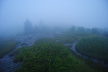
 The North Carolina High Country is a beautiful area. It is part of the Pisgah National Forest, and part of it is also classified as the Shining Rock Wilderness. The NC High Country is where the mountain tops are bald, black balsam trees/forests are abundant, and steep, rushing streams descend into the valleys below to form some of the bigger rivers in the area. The drainages on the south side eventually end up in the Mills River, whereas the drainages on the north side end up in the Pigeon River. Yellowstone Prong is one of the major tributaries of the Mills River on the south side. Just below the bald summit of Black Balsam Mountain, Yellowstone Prong begins its journey southward towards the Mills River, and on the way, it passes through an outlier: a somewhat swampy, lush mountain meadow known as Graveyard Fields. This hike occurred on Saturday, July 19th, 2014, My original plan was to start at the Graveyard Fields Overlook on the Blue Ridge Parkway, hike down into Graveyard Fields via the Graveyard Fields Loop on the west side, and then take the spur trail to Upper Falls out and back. From there, I would take the Graveyard Ridge Connector to the Graveyard Ridge Trail, and the Graveyard Ridge Trail west to the Mountains-to-Sea Trail. Next, I would take the M-t-S to Black Balsam Road, and then the Art Loeb Trail over the bald summits of Black Balsam Mountain and Tennent Mountain to Ivestor Gap. From here, I would return by taking the Graveyard Ridge Trail southward back to the M-t-S. However, to add variety, I would turn left onto the M-t-S at the junction, and then return via the M-t-S Connector to Graveyard Fields Loop. Finally, I would return via the paved path out of Graveyard Fields to the parking area at the overlook. Sounds good enough, eh? Well, what actually happened was a little different. I got to a false gap what I thought was Ivestor Gap, and when I couldn't find Graveyard Ridge Trail, I took the old logging road that went to the left and connected with Ivestor Gap Trail. I followed Ivestor Gap Trail to Black Balsam Road, and finished the hike with 3 miles of roadwalk. This description will follow the actual route of my hike. R/T Length of Trail: 12 Miles Duration of Hike: 7 Hours, 20 Minutes Difficulty Rating: 9 out of 10 Pros: Waterfall, well-marked trail junctions (for the most part), incredible views in clear weather Cons: Crowds in Graveyard Fields (possibly Black Balsam Mountain too in good weather), somewhat overgrown M-t-S Trail, very muddy after rain, very slow on Art Loeb Trail with rocks and roots everywhere in a "trail trench", roadwalk in the end with how I ended up doing this hike Best Season(s) to Hike: Fall, Winter (Blue Ridge Parkway is closed in winter but you can still access the area via a multi-day backpacking trip) Trail Blaze Color(s): Upper Falls Trail - Orange; Graveyard Ridge Connector - Yellow; Graveyard Ridge Trail - Orange; Mountains-to-Sea (M-t-S) Trail - White Circles; Art Loeb Trail - White; Ivestor Gap Trail - None and none needed. *Note: Besides the M-t-S and Art Loeb, I never saw trail blazes on any of the other trails, although maps and signs had noted that blazes should have been found somewhere. Beginning Point: Graveyard Fields Overlook on the Blue Ridge Parkway, Milepost 419 Directions: From Brevard, NC: Follow US-276 for 15.5 miles to the Blue Ridge Parkway. Take the ramp to the right onto the Blue Ridge Parkway, and then turn left onto the Blue Ridge Parkway. Follow Blue Ridge Parkway for 7.2 miles and stop at Graveyard Fields Overlook on your right just before Milepost 419. If you pass Milepost 419, you have gone too far. I try to visit the NC High Country a few times a year now. The bald mountaintops are fantastic, and the surrounding streams have good water features too. I spent several weeks planning out this mega loop, but it still didn't end up as I planned it to. I started the hike at the Graveyard Fields Overlook, which was very foggy. It seemed like I was in the clouds (and I probably was, as the cloud deck was thick and low after all the rain the day before and this morning). The Graveyard Fields Overlook recently reopened after a multi-month construction. The construction's goal was to add restrooms and additional parking spaces. Taking a look at the origin of the name "Graveyard Fields", it comes from the fact that there are graves across different portions of the Yellowstone Prong watershed. No... just kidding. ;) The name comes from when there was a fire in the 1920's that left tree trunks standing like gravestones in the fields. The fire was followed by a series of floods which washed the trunks away, and left everything in a slow recovery process. It's going to take a while for the area to fully recover after all the floods and fire. From the parking area, it may get a bit confusing as to what trail to take. You need to take the trail that is on the far end of the parking area, farther from the restrooms. If you see a set of steps going down, then you found the right trail. This is the Upper Falls Trail. After the initial set of steps, the trail becomes a dirt path and turns west. The day I went, the various vegetation was weighing on the path (laden with water) and the trail was a stream. There were several switchbacks as the trail descended down the mountainside towards Yellowstone Prong. There were also a couple small stream crossings that had some wooden planks. As the Upper Falls Trail approached Yellowstone Prong, there was a short boardwalk. Right before Yellowstone Prong, there was one more switchback, and then, the fundamental bridge over Yellowstone Prong appeared. It looked like it accommodated bikes too, although obviously, the trail is for hikers only. From the bridge, Yellowstone Prong's waters were furious. Looking west up the prong, some areas appeared to have minor flooding from the rain.It was still drizzling with more fog gradually spreading into the meadows. Shortly after the bridge, there's a T-shape trail junction. Upper Falls Trail turned left, while Lower Falls Trail turned right. The Lower Falls Trail would be the route later, but for now, I took the trail to see Upper Falls. So far, I had hiked 0.8 miles. The Upper Falls Trail starts out mostly level in the meadows. There will be a couple unofficial paths that will come in from the left and right. After 0.4 miles, there was a creek crossing. Under normal water levels, it is supposed to be easily rock-hoppable, but not on this day. With the intention of keeping my feet dry (pointless with the trails being streams), I threw in a couple new rocks, which made the crossing crossable. I think this was one of the major tributaries of Yellowstone Prong. After the crossing, the trail gradually started ascending, and it kept getting rockier. The last 0.1 mile was somewhat steep compared to what was on the trail earlier, and very rocky too. To get to the falls, you have to cross a large amount of rocks at the end of the trail to a large boulder at Yellowstone prong. Here, the lower part of Upper Falls was rushing down the steep slope. It was AMAZING after all the rain. I know the upper part of Upper Falls can be accessed too. To do that, you have to cross Yellowstone Prong, and climb up the rocks to the left of the lower part of Upper Falls. Around the bend, you can find the upper part of Upper Falls. However, I didn't attempt it today; both due to the rocks looking very slippery near the falls, and with no clear way of crossing Yellowstone Prong without getting wet. It might have been even unsafe to attempt with the speed of the water. The Upper Falls Trail's spur section was 0.8 miles long,making it 1.6 miles since the start of the hike. Counting the return back to the Lower Falls Trail junction, it became 2.4 miles. It was a short 0.2 miles on the Lower Falls trail over a coupe of bridges to another junction. Here, the Lower Falls Trail turned right to continue n its course to Lower Falls. I planned on hitting Lower Falls on my way back on the loop (before I knew how my plan would change), so I took a left here onto the Graveyard Ridge Connector. The Graveyard Ridge Connector is pretty steep, ascending 300 feet in just 0.4 miles with few switchbacks. It doesn't sound like much, but it's more than it sounds, although still not extremely bad. Once you top out on the connector, there's a junction with Graveyard Ridge Trail. Both turning left and right will lead to the Mountains-to-Sea Trail, but in order to keep the shape of my loop, I turned left. The Graveyard Ridge Trail is a mainly flat trail slightly ascending. There were more views of the now completely fog-covered Graveyard Fields, as well as a few stream crossings. This section of the Graveyard Ridge Trail was 0.8 miles long, until where it reached. the 4-way junction with the Mountains-to-Sea Trail. The sign said that I had hiked 2.2 miles from the parking lot so far, but add that to Upper Falls spur out and back, and it becomes 3.8 miles. If turning right, it is 2.2 miles to the parking area too, but via Lower Falls. Forward, the Graveyard Ridge Trail continued 2 miles to Ivestor Gap, my planned return route. And my current turn was left, where the M-t-S turned to reach Black Balsam Road in 1.5 miles. The M-t-S started off a bit overgrown and steeply ascendng with switchbacks. There was around a dozen of switchbacks as the trail ascended nearly 600 feet in 0.8 miles. I was told the trail could be quite overgrown, but mainly everywhere, the trail was clear enough to not get lost. At 0.8 miles, the trail reached a small flat spot below the summit of Black Balsam Knob. There was a rock slab with nice views in clear weather probably... but on this day, I could view the fog! After this overlook, the trail descended by more switchbacks down rock faces marked by white circular blazes t meet the headwaters of the Yellowstone Prong. There was probably around a dozen footbridges over the different branches of Yellowstone Prong. The most impressive branch had a nice waterfall too that was very steep. However, it does not have a name to my knowledge. After this, the trail gradually ascended and entered a black balsam forest. At 1.5 miles from the previous junction (and 5.3 miles since the start of the hike), the trail reached the Art Loeb Trail. The M-t-s trail turned left together with Art Loeb South, and I could see the parking pullout on Black Balsam Road. However, I turned right onto Art Loeb North. The most exciting part of the hike was supposed to start... oh, really? It was already around sunset and very foggy. The trail continued through the black balsam forest and started up Black Balsam Knob. On the slope of Black Balsam Knob, there was a majestic lone black balsam tree, which I named in my head "The Guardian of the Mountain". The trail was not very step as it ascended the summit of Black Balsam Knob. The summit is very big. It doesn't even resemble a summit. And there were outstanding views... of more fog! On a clear day, the views are certainly outstanding, as the summit is almost completely bald, with rocks, grass, and shrubs. There was a supposed to be a plaque about Art Loeb somewhere here, but I missed it. However, after this, the trail started down a narrow trench which was again full of water. The bushes around were up to my head's height. It was really slow and annoying. Then, the trail reached a gap between Black Balsam Knob and Tennent Mountain. It started the ascent up Tennent Mountain. The ascent was short, but a bit steeper than the previous one. There was another plaque at the summit (that I saw this time). It was almost dark, and again, the views were of nothing but fog. I definitely have to come back here on a better day. However, the summit of Tennent Mountain was narrow and sharp, unlike Black Balsam Knob. The trail immediately plunged down the other side. The plunge was again slow and trenched, with bushes all around. It was really annoying, because I constantly had to jump from side to side to not fall in the narrow pathway, and jump over roots or fallen branches all the time. Finally, the trail reached a sign that said "Ivestor Gap ^". I had no way of telling, though, if this was a sign to the gap or to the trail, because the sign was placed at some gap too. I figured this was Ivestor Gap, and in the dark, I searched for 20 minutes all around for the Graveyard Ridge Trail, which should bring me back, but I didn't find it. All i found was the Art Loeb ascending. When I got home, I found out that this was a false gap, and the trail had to ascend one more knob before reaching Ivestor Gap. However, I came up with an alternative option (still not knowing I was not as Ivestor Gap). I turned left onto what I thought was the Ivestor Gap Trail. Luckily, the old rad quickly led me out onto the Ivestor Gap Trail, and I kept left onto it. My new plan was to follow the trail to Black Balsam Road, and finish with roadwalk. At the false gap, I had hiked 7.3 miles since the start of the hike. Ivestor Gap Trail is a very rocky, old logging road. On this day, it was completely full of water, with tons of big puddles and streams everywhere. there were a few stream crossings too, which are passable in normal conditions. I shortly passed the Fork Mountain Trail that went right. It leads to Birdstand Mountain, and later, ends at Highway 215. It was about 2.2 miles on this old road to its end at Black Balsam Road. At Black Balsam Road, there was an old gate, and also the Art Loeb Spur Trail that went left. I am not sure where it comes out on the Art Loeb near Black Balsam Knob, because I didn't see it, but it does somewhere. At this gate, I also some people just getting ready for their hike (and it was 11 pm). Someone likes night hiking here, eh? It's now 9.5 miles from the start of the hike. Turn left onto Black Balsam Road here. The first 0.8 miles are very gradual ascent, but after that, it's all downhill to the parking area. About 3.5 miles of roadwalk. When you reach the Blue Ridge Parkway, turn left. It's all downhill. Know that when you reach John Rock Overlook on your right, you are almost finished. This hike didn't turn out as I expected it to. I don't like so much roadwalk on a hike. However, I still enjoyed the part that was without roadwalk, and I recommend doing it. Not all hikers can do the whole hike though. It's best done in two sections; a hike in Graveyard Fields, and then driving over to the second part: a hike to Black Balsam Knob and Tennent Mountain. Below are my pictures and videos. I definitely want to get back and do it in good weather. Even with the roadwalk and fog, I classify this is a "Best Hike". In good weather, it is more than a Best Hike. The views are outstanding, and the water features are very nice too.
1 Comment
8/4/2022 06:27:30 am
Edirne baymak servisi için hemen websitemize göz at! https://www.edirneklimaservisi.com/edirne-baymak-servisi/ Leave a Reply. |
About MeMark Oleg Ozboyd Dear readers: I have invested a tremendous amount of time and effort in this website and the Georgia Waterfalls Database the past five years. All of the work that has gone in keeping these websites updated with my latest trip reports has almost been like a full-time job. This has not allowed me to pick up a paid job to save up money for college, and therefore, I I've had to take out loans. If you find the information on this website interesting, helpful, or time-saving, you can say "thanks" and help me out by clicking the button above and making a contribution. I will be very grateful for any amount of support you give, as all of it will apply toward my college tuition. Thank you!

Coming in 2022-2023?
Other Hiking WebsitesMiles HikedYear 1: 540.0 Miles
Year 2: 552.3 Miles Year 3: 518.4 Miles Year 4: 482.4 Miles Year 5: 259.9 Miles Archives
March 2021
Categories
All
|
 RSS Feed